-
Posts
18,393 -
Joined
Content Type
Profiles
Blogs
Forums
American Weather
Media Demo
Store
Gallery
Everything posted by Chicago WX
-
Nov 28-30th Post Turkey Day Winter Storm
Chicago WX replied to Chicago Storm's topic in Lakes/Ohio Valley
Man, I hope you're right. What's crazy is you've got a good chance pull a 20" month (at least)...in November. Awesome start to the season. -

Nov 28-30th Post Turkey Day Winter Storm
Chicago WX replied to Chicago Storm's topic in Lakes/Ohio Valley
Nice work. Caveat on the COOP "accuracy" for sure. Some sketchy measurements in past years. Regardless, this is definitely a November for the books around here, assuming this storm acts as expected. With that said, gonna narrow my range a bit and go 6-8" final call for here. General consensus QPF numbers in the 0.60-0.80" range, ratios pretty close to 10:1, etc etc. Going to be a fun day to work tomorrow. -

Nov 28-30th Post Turkey Day Winter Storm
Chicago WX replied to Chicago Storm's topic in Lakes/Ohio Valley
4-8/6-10" looks like a decent range for here. Pretty good agreement amongst the ensembles of a range of 0.60-0.80" total QPF. Not really worried about p-type, and if it changes to snizzle, it should be after 95% of the storm has done its damage. Regardless, need 4.6" to hit double digits for November, which is pretty freaking fantastic. -

11/8-11/10 First Snow and Lake Effect Event
Chicago WX replied to Geoboy645's topic in Lakes/Ohio Valley
4.7" the final here. Total since yesterday was 5.4" with the Sunday morning snowfall (melted in the afternoon). Last gasp snow was really ripping, tacking on an additional inch in 30 minutes. Pretty pleased considering it's November 10, but to just miss a foot+ by 13 miles or so, eh... EDIT: report of 9.0" in Iroquois county to the south. -

11/8-11/10 First Snow and Lake Effect Event
Chicago WX replied to Geoboy645's topic in Lakes/Ohio Valley
Jackpot. Congrats. Snowing hard here right now with this last gasp. -

11/8-11/10 First Snow and Lake Effect Event
Chicago WX replied to Geoboy645's topic in Lakes/Ohio Valley
Totally different set up, but the results kinda reminds me of this one, Feb 24, 2016. RC has fond memories. https://www.weather.gov/lot/2016feb24_snow -

11/8-11/10 First Snow and Lake Effect Event
Chicago WX replied to Geoboy645's topic in Lakes/Ohio Valley
Measured 3.5" at 4:00 am. Still snowing, but fairly light. Just to put the put the Momence total in context, they're 13 miles to the east of IKK. Will be some varying storm totals from west to east in the county, to say the least. -

11/8-11/10 First Snow and Lake Effect Event
Chicago WX replied to Geoboy645's topic in Lakes/Ohio Valley
Wow, awesome. This one just missed MBY. I mean I'll take what I got, but a foot... -

11/8-11/10 First Snow and Lake Effect Event
Chicago WX replied to Geoboy645's topic in Lakes/Ohio Valley
3.5" here at 4:00 am. Looking at radar since this started, the eastern half of the county (east of IKK) will do best. But yeah, only a handful of "pure" LES events that dropped 3"+ here, that I can recall. Last one was in the winter of 2013-14 (Jan 21-22). -
Pea sized hail here right now. Just pouring down. Yard is covered. Temp down 20 degrees in minutes. Storm earlier today around 1:30 was probably the coolest looking clouds I’ve seen. Sky looked like mud with the dust, and it was dark as night. Should’ve snapped a pic, but I guess I was too much in awe.
-

Winter 2024-25 Medium/Long Range Discussion
Chicago WX replied to michsnowfreak's topic in Lakes/Ohio Valley
This sorta kinda worked out. Systems themselves weren't noteworthy, but the EPS flagged them pretty well. 6" total IMBY. Wished they would've been better. Looks like the last of the 3 will be the biggest dog of them all, as MO, southern 1/2 or 1/3 of IL/IN/OH look to grab a pretty good snowstorm this week. Funny how the "southern" storms tend to work out well this winter... -
1.5" from the WAA here. And looks like that will be final.
-
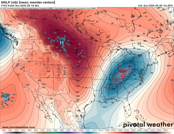
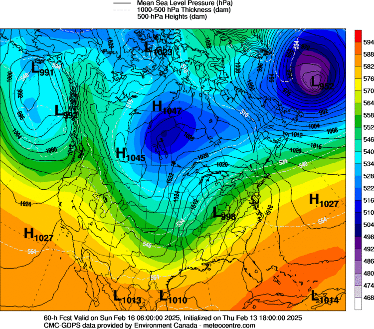
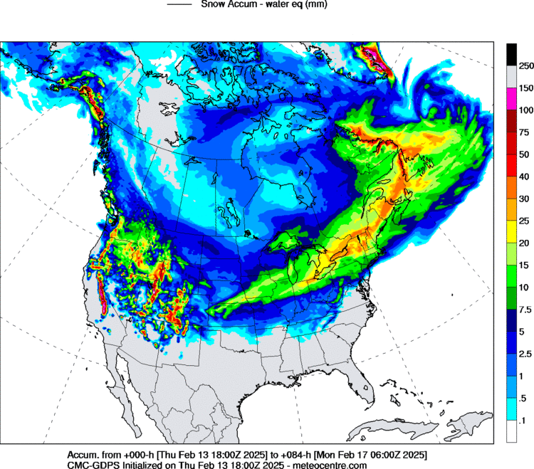
We're running out of time. I'd still trust the Euro/EPS over any other piece of guidance, and it has come farther northwest every run since 0z Thursday. But they are relatively small bumps. I think we're cooked to be honest, but parts of Indiana, Ohio, Michigan, and Ontario may still do well with the main show. 6z runs were a step back across the board, so that isn't good for us. If I can somehow pull 2-3" total out of this whole thing, I'll consider it a win. But, what could have been...
-
Somewhat desperate times I guess, but here's the 18z GGEM. Hits NE IN, NW OH and SE MI pretty good. Decent for the rest of us.
-
Yeah, seems that way. There's been a few models, some bad models, that have liked the idea of this storm. But getting the EC and GFS on board would be reassuring. Hopefully their respective ensembles are leading the way.
-
18z GEFS more amped.
-
QPF on the EPS mean is showing more for a deformation with the 12z run. It’s not “wet”, but it’s a start.
-
We ride with the Ukie and the Canadian twins.
-
January was decent here despite the CAD hell. We again got lucky with KC-STL-Louisville storm in Jan. Caught a fgen band that dumped 3” in 2 hours, and then other pennies and nickels along the way. Had snow cover almost the entire month.
-
Final: 4.5" on 0.32" liquid, 14:1 ratio. Up to 20.6" for the season.
-
ILX radar starting to light up with this next round. If you can get lucky and get stuck under ones of those bands for awhile, it'll heal some wounds.
-
That's the truth. After our first push today, we went to needles. When the good returns moved back overhead later, back came the good flakes. Speaking of, getting another one of those right now. Measured 2.8" when I got home from work, so we'll beat the season high event of 3.0". I'll take it.
-
It’s backed off now, but you’ll enjoy if you get into it. Solid hour of rip city. Thing is, there was a better looking band that went south of here thru Iroquois county.
-
Stopped at my house and measured. Total weenie move, but whatever. 2.5” so far. Still dumping. Got very very lucky here.
-
Rip city here for the past 30 minutes and still going. Flake size back to good, visibility about a block currently. I’m pleased.

