

WeatherMonger
-
Posts
715 -
Joined
Content Type
Profiles
Blogs
Forums
American Weather
Media Demo
Store
Gallery
Everything posted by WeatherMonger
-
ILX rated the 4th tornado an EF2 as well, said it was same storm as Cass County south of Virginia.
-
A lot of pictures I have seen remind me of some of those from Greensburg, KS but haven't heard it mentioned in comparisons. Greensburg was a smaller and more compact town, but not so different than some of these denser populations of bigger towns/cities. I'm not an expert or even educated in the field, so not ssying such is so.
-
ILX found damage from a 4th tornado
-
It's horrible. Watched the briefing on it. They have no idea how many are unaccounted for. Amazon has not reached out to any of the responders or emergency agencies. They have already put an end to rescue efforts and are now recovery only from 7am to 5pm daily, basically only working in daylight conditions. They said part of the reason for not knowing how many are still unaccounted for was it occured during a shift change and there was also part time employees involved. They did not know if there was a designated storm shelter in the facility. Only mention of Amazon corporate was that Pritzker had said he contacted them and told them they need to step up and help the community and victims families. No one from Amazon had been on site to assist.
-
Given an EF2 rating today
-
What a nightmare of a storm.... Usually gulf coast states this time of year
-
He only had a limb come down, said emergency vehicles have sirens activated heading south of town
-
Could be rightx would be to the south of him if so
-
Thunder just starting here, not in any threat. Looking to be split by the warned cells to the north and south. Nothing but liggy to moderate rain
-
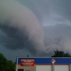
Have a coworker who lives in Virginia, he said it is rain and wind currently. Had a funnel cloud reported with it when it was nearing Arenzville. May have dropped after Virginia if it did.
-
Storm east of Columbia, MO moving at 80mph
-
Vividly just wish I was on a forum like this or accuweather at the time. 5 days later we were in a Blizzard warning
-
Didn't last but about 1 minute
-
Just started pouring snow here
-
I'm not sure I like this Baker's attitude..... Heading into the start of next week, the upper flow is forecast to become more zonal. This would open the doorway for another weather system to develop and slide through the mid-latitudes Monday night into Tuesday morning. This is also the first look at possible frost development across a decent amount of land in the central Illinois area, as lows Tuesday and Wednesday mornings drop into the mid 30s Tuesday and low to mid 30s Wednesday. With temperatures falling towards the freezing mark, and precipitation chances Tuesday and Wednesday mornings, we`ll have to keep an eye out for possible pesky white dendrites falling from the sky...but for now we will think positive LONG TERM...Baker
-
 Going to miss KSPI altogether
 -
Possible severe weather Monday
WeatherMonger replied to StormfanaticInd's topic in Lakes/Ohio Valley
ILX radar is updating now. -
Possible severe weather Monday
WeatherMonger replied to StormfanaticInd's topic in Lakes/Ohio Valley
-
Possible severe weather Monday
WeatherMonger replied to StormfanaticInd's topic in Lakes/Ohio Valley
Mesoscale Discussion 1831 NWS Storm Prediction Center Norman OK 0906 AM CDT Mon Oct 11 2021 Areas affected...eastern MO...western and central IL Concerning...Severe potential...Watch possible Valid 111406Z - 111630Z Probability of Watch Issuance...60 percent SUMMARY...Trends will be monitored this morning for surface-based thunderstorm development. The initial area of concern will be over central MO and areas northeastward towards the MS River. A tornado watch will likely be needed by midday for portions of eastern MO into western IL. It is uncertain whether surface-based storms and a subsequent tornado risk will develop as far north as extreme eastern IA. DISCUSSION...Visible-satellite imagery shows a compact/intense mid-level shortwave trough over the lower MO Valley. Weak convection has been maintained this morning within the warm conveyer belt from southeast MO through the Saint Louis area and into western IL. A surface trough/windshift is analyzed this morning arcing from near the low through central and south-central MO. A small area of cloud breaks is noted in visible-satellite imagery over central MO where forcing is maximized and over the location of greatest concern this morning. Model forecast soundings show gradual destabilization this morning into the midday hours as temperatures slowly rise into the lower 70s with a moist boundary layer. Very strong low-level flow noted at the Saint Louis 88D VAD is resulting in a large low-level hodograph (400+ m2/s2 0-1 km SRH). Once sufficiently strong updrafts can develop/persist, a severe risk will likely ensue with an isolated risk for tornadoes and damaging winds being the primary concerns. ..Smith/Hart.. 10/11/2021 -
-
-
-
Curious to see if they find a brief spin up occured


