

WeatherMonger
-
Posts
715 -
Joined
Content Type
Profiles
Blogs
Forums
American Weather
Media Demo
Store
Gallery
Everything posted by WeatherMonger
-
Airport recorded .3" from the band last night, 2nd biggest snowfall of the year/season. 2.1" total.
-
3rd biggest snow of the season tonight. Might have gotten .1", also the 3rd measurable snowfall if so. Bring on Spring mushrooms amd turkey
-
1.6" here, 1.8" on the season/year.
-
I wish I was better known on this forum for a quip back
-
Going with the cut off looks like ILX has you nearer the 4" mark than 1", on the higher end of the spectrum. Normally I'd be rooting for the GFS, but have to hope for the Euro so I can get back to work Tuesday with running water.
-
Plumbers are coming Monday to put in a new water line. I'm hoping this snow will be somewhat fluffy so I can use a leaf blower to uncover all the locator markings they plotted today and tomorrow. My luck sucks
-
Don't worry, just had the main waterline to the house bust. My bad luck will be your good luck, east it will come because I need it west now.
-
.2" here and think that was kind of a stretch, plus a trace in December. If we don't get anything by Valentines day I'll be ready to move onto Spring, which is when I'll get denied that wish and tormented with snows that last 3 days. I would take another Palm Sunday snow like the one several years ago. 17.5" and gone by Good Friday.
-
It wasn't me
-
Latest ILX totals
-
Airport is going to have atleast .1" so record will stand here. Some other totals in ILX CWA
-
I'd rather have none than nickels for 4 months to reach a dollar. Mother Nature usually has a way of equallizing things, took until December for the severe to somewhat break even for the year. I just don't want winter in April and May Give me a couple half dollars or a silver dollar and in the end I'll be happy.
-
ILX posted this on FB a couple hours ago. Actually hoping they're wrong, would rather break the latest measurable snowfall record than a dusting. Some banding regenersting but nothing really holding up, can't imagine it's going to fill in that greatly over the next 2 1/2 hours.
-
Sleet and ZR at KSPI.
-
ILX likes the NW track. Surface cyclogenesis will develop in SE Colorado Friday, with the low tracking to western Missouri by 6 am on New Years Day/Saturday. A warm front ahead of the low will advance into a cold Canadian high pressure in place across the northern Midwest. The 12z model suite has kept the general trend of ECMWF with the northerly track of the low and the GFS the southerly track. GFS ensemble output is targeting central IL (roughly the I-72 corridor) for some of the heavier snows from that system. The ECMWF continues to target northern IL for heavier snows, roughly north of Galesburg to south Chicago. The blended extended guidance in our system is leaning toward the northerly track, and keeping snow amounts down and mainly northwest of Peoria. While freezing rain signals are present in the transition zone soundings, it does not appear to be a good setup for an ice storm in any of our counties, with a lack of persistent sub- freezing dewpoint air feeding in from the northeast. Still, there is potential of high impact to travel New Years Day, so anyone with travel plans toward northern Illinois will need to keep a close eye on updates to this winter storm system. After the surface low passes on Saturday, much colder air will arrive on gusty NW winds. Wind chills will likely drop into the zero to -15F range by Sunday morning, which will be a rude awakening after a warm December
-
Winter 2021-22 Short/Medium Range Discussion
WeatherMonger replied to Chicago Storm's topic in Lakes/Ohio Valley
That it did, 1 amd 1.2" respectively. -
-
Winter 2021-22 Short/Medium Range Discussion
WeatherMonger replied to Chicago Storm's topic in Lakes/Ohio Valley
16 days remain for KSPI and KPIA record for first measurable snow. -
-
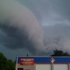
December 15th-16th Warmth, Wind, and Severe Threat
WeatherMonger replied to Geoboy645's topic in Lakes/Ohio Valley
KSPI with a 59mph max gust yesterday -
December 15th-16th Warmth, Wind, and Severe Threat
WeatherMonger replied to Geoboy645's topic in Lakes/Ohio Valley
DVN and LSX keep letting the edge of their CWA's drop warnings in the middle as it moves into ILX CWA. Not sure what ILX will do with it. 70mph on DVN side and 60mph on LSX. Probably dry up before it gete here though. -
December 15th-16th Warmth, Wind, and Severe Threat
WeatherMonger replied to Geoboy645's topic in Lakes/Ohio Valley
Was just about to post that for here. So far last 2 hourly uodates had gusts to 56mph. Just went outside and it's ripping out there. -
December 15th-16th Warmth, Wind, and Severe Threat
WeatherMonger replied to Geoboy645's topic in Lakes/Ohio Valley
Looks like the airport recorded a 56mph gust last hour here -
December 15th-16th Warmth, Wind, and Severe Threat
WeatherMonger replied to Geoboy645's topic in Lakes/Ohio Valley
-
December 15th-16th Warmth, Wind, and Severe Threat
WeatherMonger replied to Geoboy645's topic in Lakes/Ohio Valley
Expanded the moderate and added hatching to the 10% area


