

WeatherMonger
-
Posts
715 -
Joined
Content Type
Profiles
Blogs
Forums
American Weather
Media Demo
Store
Gallery
Everything posted by WeatherMonger
-
not recognizing text on copy and paste. Tornado watch issued for central and NE IL, NW IN and Lower MI
-
Mesoscale Discussion 1109 NWS Storm Prediction Center Norman OK 1145 AM CDT Sat Jun 26 2021 Areas affected...Parts of east central Missouri through central/northeastern Illinois and adjacent northwestern Indiana Concerning...Severe potential...Watch possible Valid 261645Z - 261845Z Probability of Watch Issuance...60 percent SUMMARY...Thunderstorm development likely will continue to increase through 1-3 PM CDT, posing at least some risk for isolated tornadoes and damaging downbursts. DISCUSSION...Deepening convective development is ongoing along a narrow corridor of destabilization largely driven by daytime heating. This is occurring near a remnant convectively generated surface boundary, along which low-level convergence is focused and maintaining mid 70s F surface dew points, from the Greater St. Louis metro area north-northeastward into the Greater Chicago area. This is also along the southeastern periphery of a lower/mid tropospheric cyclone centered over Iowa, with a remnant MCV also migrating northeast of the Springfield, MO area, toward St. Louis. Lapse rates are generally weak, but the low-level moisture appears to be contributing to mixed-layer CAPE in excess of 1000 J/kg, which could increase to 1500-2000 J/kg with continuing insolation. Furthermore, the axis of destabilization is aligned with a south-southwesterly 850 mb jet migrating across the middle Mississippi Valley toward the Great Lakes region. Moderate to strong low-level shear will support rotation in developing updrafts, some of which may occasionally strengthen and pose a risk for at least brief tornadoes. Otherwise, consolidating/ upscale growing storm clusters are also possible and may be accompanied by a risk for damaging downbursts. ..Kerr/Hart.. 06/26/2021 ...Please see www.spc.noaa.gov for graphic product... ATTN...WFO...LOT...ILX...LSX...
-
Tornado Warning just south of Reading IL
-
SPC extended the light risk SW into east central MO, 5% tornado didn't change. ...SUMMARY... Scattered strong to severe thunderstorms are possible this afternoon from east-central Missouri to parts of Lower Michigan, and over parts of the southern High Plains. Damaging winds and perhaps hail are possible in those areas, along with a tornado or two over the Illinois-Michigan corridor. ...MO to MI... A convectively aided baroclinic zone is shown on recent surface analysis from south-central MO into central IL - then northeastward into lower MI. Relatively strong heating is occurring along this boundary, and ample moisture is present to the south. This will aid in moderate MLCAPE values and the development of scattered thunderstorms along this entire corridor later today. Low and mid-level wind fields are southwesterly and relatively uni-directional, but are strong enough to pose a risk of some convective organization. Bowing structures as well as occasional supercell storms are expected. Damaging winds appear to be the main threat, but sufficient shear will be present to pose some risk of a tornado or two as well. The severe threat should diminish by mid-evening as nocturnal cooling ensues.
-
Starting to see some distant lightning on security cams. Warning is not being extended. Been a superstition here for decades, gets disproven every so often....
-
Lightning falling behind the leading edge. Weaken my storm, let the gust flow out from you... Then Now
-
-
Newest warning here just shy of my doorstep. Making up a new drink shortly and heading outside. Aside from lightning I'm good. Will most likely fall apart as they always do, always the chance that it may not.
-
At this rate I might not even get a raindrop seems to be a bit north of guidance as far as training of heavier QPF
-
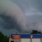
Missouri doesn't even have much going on, definitely not "robust" This is the image I meant to post on the earlier central IL tornado warned storm. Might have had at least a funnel cloud under it.
-
Decent rotation on it past couple frames
-
URGENT - IMMEDIATE BROADCAST REQUESTED Severe Thunderstorm Watch Number 317 NWS Storm Prediction Center Norman OK 510 PM CDT Fri Jun 25 2021 The NWS Storm Prediction Center has issued a * Severe Thunderstorm Watch for portions of Central Illinois Central and northeast Missouri * Effective this Friday afternoon and evening from 510 PM until 1100 PM CDT. * Primary threats include... Scattered damaging wind gusts to 70 mph possible Isolated large hail events to 1.5 inches in diameter possible A tornado or two possible SUMMARY...Multiple clusters should develop and spread east-northeast from central Missouri through central Illinois this evening
-
Mesoscale Discussion 1096 NWS Storm Prediction Center Norman OK 0446 PM CDT Fri Jun 25 2021 Areas affected...central Missouri to central Illinois Concerning...Severe potential...Severe Thunderstorm Watch likely Valid 252146Z - 252245Z Probability of Watch Issuance...80 percent SUMMARY...Severe thunderstorm watch appears warranted to account for expected upscale convective growth over the next several hours. DISCUSSION...Despite earlier MCS that spread across the Midwest, rapid air mass destabilization is occurring just southwest of the STL area. Further destabilization is expected downstream across central IL over the next few hours which should contribute to robust convection. Latest satellite imagery exhibits a line of deepening cumulus, with some showers, from near SPI to north of CMI. Thunderstorms will likely evolve along this corridor soon. Additionally, larger cluster of strong/severe storms should propagate across central into eastern MO with a threat for hail/wind. WW will likely be issued soon. ..Darrow/Grams.. 06/25/2021 ...Please see www.spc.noaa.gov for graphic product... ATTN...WFO...LOT...ILX...LSX...SGF...EAX... LAT...LON 39549270 40748829 39388781 38439003 38169268 39549270
-
ILX thoughts .SHORT TERM...(This evening through Saturday) ISSUED AT 343 PM CDT Fri Jun 25 2021 Surface analysis this afternoon depicts a stationary front stretched from northern IL into IA well north of the area. An outflow boundary is positioned across southeast IL into central MO with convection ongoing in our far southeast IL counties as well as new activity firing over central MO as of 3 PM. Elsewhere, a break from the precipitation is occurring with some breaks in the clouds noted across west-central portions of the state. SPC mesoanalysis depicts MLCAPE starting to build northward with clearing, though we remain capped (50-150 J/kg) from about I-70 northward from earlier convection. This will prevent anything from developing in these areas for the next few hours. Confidence in the evolution of activity going into tonight remains low. Once the CAP erodes, scattered storms should develop across west-central IL along the ouflow boundary sometime later this afternoon or early evening, which the 25.18Z HRRR picks up on. However, CAMs have not been performing well. The idea is that coverage will increase by tonight as a few mid-level waves ripple through the southwest flow aloft and the LLJ kicks in. Strong to severe storms remain possible across locations south of I-74 with damaging winds and large hail being the main threats. However, decent low- level shear with a boundary in the area could support a brief tornado or two
-
Day 1 Convective Outlook NWS Storm Prediction Center Norman OK 1147 AM CDT Fri Jun 25 2021 Valid 251630Z - 261200Z ...THERE IS A SLIGHT RISK OF SEVERE THUNDERSTORMS FROM THE CENTRAL/SOUTHERN HIGH PLAINS TO MIDWEST... ...SUMMARY... Scattered strong to severe storms are expected this afternoon into tonight from portions of the southern/central High Plains to the Midwest. Damaging wind gusts, large hail and a couple of tornadoes are possible. ...Eastern Kansas to Midwest including IL/IN/OH/Lower MI... Multiple corridors of storm development and intensification are expected across the region by mid/late afternoon, influenced by multiple MCVs as well as an outflow-reinforced effective front. Damaging thunderstorm winds and a couple of tornadoes should the primary risks, with severe hail also a possibility particularly across the Kansas/Missouri portion of the Slight Risk. This is where buoyancy will be more robust with deep-layer/low-level shear are expected to be maximized along the modifying boundary across eastern Kansas into western Missouri. Some initial supercells capable of all hazards, including a tornado risk, will be possible prior to storm mergers occurring with gradual upscale growth during the evening with an increasing damaging wind potential. Other severe storms may develop by mid/late afternoon along the residual boundary across south-central Illinois into Indiana. Although instability is a bit uncertain given persistent convection/cloud cover at midday, a late-afternoon clearing trend in conjunction with MCV-related enhanced wind profiles could support some supercells/sustained multicells within a corridor across northeast Indiana/northwest Ohio into Lower Michigan. Presuming sufficient destabilization, a couple of tornadoes and damaging winds could occur.
-
Yeah I fixed it, hyperlink reverted back to yesterdays for some reason.
-
1630Z update
-
Trim back the slight risk in IL towards the enhanced risk and SPC nailed it.
-
Storm went severe for wind to my south, pouring rain currently
-
Been raining moderately to heavy for 30 minutes now, amazing how bright it is outside.
-
Fell apart as it neared me as well, was looking forward to some thunder and lightning. Might not get anything more than a few sprinkles. SPC trimmed back the hatched winds on the eastern extent. As late in the day as it is and been heavy cloud cover all day, thought they would trim the slight back to the MS River.
-
Hydrologic Outlook ILC017-019-021-023-029-035-039-041-045-057-095-107-113-115-123-125- 129-137-139-143-147-167-169-171-173-175-179-183-203-241700- Hydrologic Outlook National Weather Service Lincoln IL 359 AM CDT Thu Jun 24 2021 ...Heavy Rainfall and Flooding Potential Tonight through this Weekend... A prolonged periods of showers and thunderstorms tonight through this weekend will likely bring widespread rainfall totals of 3 to 6 inches, with locally higher amounts possible along and north of I-72. Heaviest rainfall rates from thunderstorms could exceed 2 inches per hour. This amount of rainfall could lead to flooding in streams and urban areas as well as in low lying areas prone to flooding. CONFIDENCE STATEMENT: Confidence is medium to high on the storm system impacting the region. Confidence on the exact locations of heaviest rainfall and impacts of flooding across central Illinois remains low at this time. ADDITIONAL INFORMATION: If you reside in a flood prone location you should monitor forecasts through this weekend on this developing hazardous weather situation. Now is the time to think about preparedness and plan for impacts in the event the heavy rainfall and flooding materialize
-
WPC backed off rhe 7"+ area aside from a small blip South of Chicago Edit: Unless this morning's rain in that area was the reasoning for the 7+ totals.
-
June 20th, 2021 Severe Weather Event
WeatherMonger replied to MazooWeather's topic in Lakes/Ohio Valley
ILX UPDATE... Issued at 803 PM CDT Sun Jun 20 2021 Thunderstorms continue to increase in coverage along and ahead of an advancing cold front in IA/MO this evening. While a special 19Z KILX raob was overall unimpressive, the latest 00Z sounding shows MLCIN decreasing to 54 J/kg while instability has increased, now measuring over 2000 J/kg MLCAPE. Veered 0-3 km wind profile and deep layer shear to around 40 kt will support organized storms and a severe threat into portions of west central and central Illinois this evening. Do anticipate some downward trend in storm intensity starting around midnight as storms cross the I-55 corridor as we lose daytime heating and diurnal instability wanes. -
June 20th, 2021 Severe Weather Event
WeatherMonger replied to MazooWeather's topic in Lakes/Ohio Valley

