

WeatherMonger
-
Posts
715 -
Joined
Content Type
Profiles
Blogs
Forums
American Weather
Media Demo
Store
Gallery
Everything posted by WeatherMonger
-
June 20th, 2021 Severe Weather Event
WeatherMonger replied to MazooWeather's topic in Lakes/Ohio Valley
Was in MD 1039 A downstream watch into eastern MO and perhaps western IL may be needed if an organized wind threat becomes apparent. -
June 20th, 2021 Severe Weather Event
WeatherMonger replied to MazooWeather's topic in Lakes/Ohio Valley
Area Forecast Discussion National Weather Service Lincoln IL 244 PM CDT Sun Jun 20 2021 .SYNOPSIS... Issued at 244 PM CDT Sun Jun 20 2021 A strong cold front will push into the region from the northwest tonight. Strong to severe storms are possible ahead of the front, into tonight. Scattered showers and a few storms will linger behind the front on Monday, along with much cooler temperatures. && .SHORT TERM...(This evening through Monday) ISSUED AT 244 PM CDT Sun Jun 20 2021 Complex of storms has weakened as it pushed into western IL early this afternoon. 19z ILX sounding indicated a layer of warm air centered at 850 mb, providing a significant cap for deeper convective development. Besides the cap, the atmosphere is supportive of robust convection given 60 kt winds at 500 mb and mid level lapse rates at 7C/km. Latest forecast soundings and SPC mesoanalysis show a weaker cap over eastern IL, which could be eroded from outflow moving in from the west. Latest hi-res visibile satellite imagery shows modest cu development east of I-57. This will be the area to watch over the next few hours, and the last few runs of the HRRR have shown discrete convection here between 21-00z. All severe modes would be possible given nearly 3k J/kg MLCAPE and strong deep layer shear near 50kt, but with the warm front located farther north near I-80, damaging winds and hail are primary threats. A line of thunderstorms is expected to develop ahead of a cold front across eastern Iowa early this evening, then push into the northwest CWA towards mid evening. Severe storms are possible given moderate instability and favorable deep layer shear. Damaging winds gusts are the primary threat, with hail and an isolated QLCS tornado possible. A localized flash flood threat exists due to high rainfall rates when PWs peak over 1.75" this evening. As the line shifts farther southeast into central IL near I-55 towards midnight, conditions become less favorable for both severe and flash flooding with decreasing instability. The weakening trend continues overnight with diminishing storm coverage expected near and south of I-70 late. Southwest gradient winds gusting over 20 mph ahead of the front this evening, will veer west northwest post frontal late tonight, also gusting over 20 mph. -
June 20th, 2021 Severe Weather Event
WeatherMonger replied to MazooWeather's topic in Lakes/Ohio Valley
SPC with no changes -
June 20th, 2021 Severe Weather Event
WeatherMonger replied to MazooWeather's topic in Lakes/Ohio Valley
Hoping all the cloud cover from the weakening rain to the NW hasn't ruined it altogether. Definitely not falling in line with SPC's original timing. Reed Timmer stated this morning that things didn't look as promising in Eastern IA and IL and opted not to chase. Mesoscale Discussion 1035 NWS Storm Prediction Center Norman OK 0202 PM CDT Sun Jun 20 2021 Areas affected...Southern Iowa...northern Missouri...and northeast Kansas Concerning...Severe potential...Watch possible Valid 201902Z - 202100Z Probability of Watch Issuance...40 percent SUMMARY...Scattered strong to severe thunderstorms may develop along a southeastward moving cold front by the mid afternoon hours. The strongest storms may pose a severe hail and damaging wind risk. A watch is possible. DISCUSSION...Latest GOES visible imagery shows a growing field of cumulus along the southern IA/NE border in the vicinity of a cold front and nearby surface trough (with a shallower field noted along the front stretching back to the southwest into northern KS). The cumulus along the IA/NE border have taken on more agitated characteristics with some vertical development noted in the past 30-60 minutes. Modified morning soundings, as well as RAP forecast soundings and mesoanalysis estimates, suggest that MLCIN is waning as temperatures climb into the upper 80s with upper 60s/low 70s dewpoints. These trends suggests that convective initiation is possible in the coming hours (likely by mid afternoon) - initially within the IA/NE cumulus field and then possibly along the cold front to the southwest. A favorable parameter space just ahead of the cold front (1000-2000 J/kg MLCAPE and 40-45 knots of effective bulk shear) should support strong convection. Deep-layer flow oriented nearly orthogonal to the cold front may support initially discrete to semi-discrete modes that may pose a hail/wind threat. However, slightly cooler/stable outflow from prior convection across northern MO/southern IA and increasing inhibition southwestward into KS introduce some uncertainty into the spatial extent of the threat. Air mass recovery trends across northern MO/southern IA will continue to be monitored and a watch is possible in the coming hours. ..Moore/Hart.. 06/20/2021 -
Won't imbed, no clue on legitimacy of it. https://www.facebook.com/1599166719/posts/10223565364794423/
-
IA lit up
-
Lightning starting up in IA, not going to stay up for any additional rounds. A bit of whiskey tonight and might not even be awakened by thunder if another round happens
-
We'll see
-
I don't know why ILX puts a warning on some of these storms. Think they jumped the gun on this second warning. Barely even heavy rain, lasted about 3 minutes
-
Built up to the North, now under a warning, Not expecting much, but man it has been a boring stretch lately
-
Now warned but going to miss to my south
-
Couple cells starting to my west near Jacksonville
-
Lightning strike to my NW, hoping that's the signal the western end of things might be set to go. Usually get capped when we're in the 90's and storms fail, hit 99 here today.
-
You may be referencing @Central Illinois
-
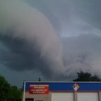
When I first seen this I thought it could be the wall cloud dissipating or something. Never seen a tornado or tornadic cell in daylight. Wasn't any rotation that I could see but not sure how evident it is from a few miles away. Just seen a ring like pattern and was intrigued.
-
Anyone see any confirmed debris signature in the Pleasant Plains area when it was confirmed? Waiting to hear back from a high school friend there in hope's he faired well.
-
I'm not sure what I was looking at to my NW and eventual North. I couldn't see any clear cut rotation to be the wall cloud of the storm. I have a horrible view from my backyard and kept wandering out trying to get a view in gaps between obstructions and lightning was my biggest fear lol. Wasn't a whole lot of thunder nor lightning here. I think it was just a bit too far away for me to have had a visual on the main part of the storm. Maybe this tail end Charlie can give me a thunderstorm warning. Was still some pretty cool cloud formations regardless.
-
Dead calm here
-
I'm about here
-
Sirens going off here, we'll south of the Storm but they are mainly for Sherman about 4 miles away
-
Stuck in the Dr. office watching radarscope and each warning picks up speed I'm not overly optimistic, they always weaken or split as they near and restrengthem after passing. I just hate being windowless
-
Hit 79 today, also think a wind advisory could have been justified. Been some good gusts and limbs coming down this afternoon/evening.
-
Decent little storm moved through here, was surprised when I pulled up radar ILX put a warning on it. Came through a bit differently than usual. First a batch of heavy rain moved through, then a few CTG's with some decent thunder claps. Then it started a light rain and thought the warning was kneejerk. About 8:12 the winds started coming in, had about 4 or 5 pockets of winds I wouod guesstimate near 45'ish mph. Next door neighbor has a maple thathas been slowly dieing the past few years and neighbor across the street has two 75 foot ash about 38" in diameter that are completely dead. Was expecting some branches to come down or worse, but the way the winds gusted in short bursts they all survived. Didn't get any hail here, wish there was lightning behind the leading edge though. Lools lioe just showers the rest of the way. I could see some areas within the warning getting severe gusts. Definitely ready for Spring to spring though.
-
I'm pre-internet as well , born 4 months after this event.
-
Apologies for not knowing where to post, but can you imagine 47 years ago and no access to models or Meso Discussions...
