WeatherMonger
-
Posts
715 -
Joined
Content Type
Profiles
Blogs
Forums
American Weather
Media Demo
Store
Gallery
Everything posted by WeatherMonger
-
Feels like a WWA during a Blizzard, but might get a watch here
-
Happens every now and again, but I'm always impressed when the outflow/gust front prompts warnings ahead of it. People nit reading it probably confused at lack of a storm approaching yet under a warning.
-
Just had some heavy rain where I was, driving home was interesting at times. A lot of water on roadways, mad it through the viaduct though, was only about 1 1/2 feet deep. Wish I was home enjoying rather than driving through it though.
-
Actually produced per SPC reports. I was telling a coworker funnel cloud at min. on this scan.
-
Under a warning but see no need for it. Had a good CTG just north of me, took about 10 seconds to get the thunder clap. Light rain, good temp drop of 15-20 degrees and very little wind at my location, SW side of Springfield.
-
Cell to my SSW near Girard started to go up then completely fell apart. May serve as a trigger for something if an outflow can drift towards me or could overturn the airmass and negate any other chances. If I were a betting man I'd choose the latter as it seems to happen 85% of the time.
-
Slight Risk added for IL at 1630Z update
-
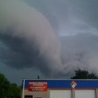
Coworker got a small video of the tornado in south central IL today. Hoping this screenshot of it uploads. Looks like a small stovepipe
-
I remember it well, it's how I found Acccuwx in 2010, found a few forums with threads following the days events. I'm not saying it can't happen, just how it usually pans out. I'll pass on another 3/12/06 though. Was about 200 yds off the northern edge of the path of the first(main) tornado. Was outside trying to get some lightening pics listening to Gus Gordon(local met at the time) talk about a confirmed tornado less than 1/4 mile from me headed towards me Finally let out an audible shriek as winds got into the probable 90mph range, back sliding glass door was a straight shot from front door. Seen the power flash as the weatherhead was ripped down. Was under a blizzard warning before power was restored Definitely got lucky on that one and one of the reasons I tend to hope for but not get overly disappointed when strong storms are forecast. Never know when "that one" is going to actually happen.
-
To the bolded
-
Well to my west near Franklin(Jacksonville area) from a coworker
-
This is from a friend in the Chatham/Loami area to my SSW
-
Had a bit of a gust out here. Not showing up on radar yet but had a weak wanna be shelf/roll cloud with some wind come through then the rain started well ahead of radar reflections. Lightning well off to the west but no way it strengthens now. Lots of lightning but not much thunder.
-
Going to be the same old song and dance IMBY, doesn't matter if it rains all morning or plentiful sunshine. Sangamon county is a storm killer. Always regains strength after passing.
-
County level
-
-
Warch coming for my area
-
Beat me to it, just got home and seen that. I know better than to get my hopes up, but 3 straight days in a Mrgl or Slight. Still haven't heard thunder this year.
-
CPC still with a rather large severe area in the 8+ day range. SPC and WPC have nothing delineated in the 7-8 day range, SPC with predictability too low. New thing for CPC? Usually the delineate the SPC and WPC areas of notez but now they are going out on their own beyond warmer/colder than average.