

WeatherMonger
-
Posts
715 -
Joined
Content Type
Profiles
Blogs
Forums
American Weather
Media Demo
Store
Gallery
Everything posted by WeatherMonger
-
March 26-28 Severe Threat
WeatherMonger replied to Tim from Springfield (IL)'s topic in Lakes/Ohio Valley
About 7 hours late but sun shining here in KSPI -
March 26-28 Severe Threat
WeatherMonger replied to Tim from Springfield (IL)'s topic in Lakes/Ohio Valley
Newest watch, has 50/20 probabilities -
March 26-28 Severe Threat
WeatherMonger replied to Tim from Springfield (IL)'s topic in Lakes/Ohio Valley
No High Risk -
March 26-28 Severe Threat
WeatherMonger replied to Tim from Springfield (IL)'s topic in Lakes/Ohio Valley
69/67 KSPI -
March 26-28 Severe Threat
WeatherMonger replied to Tim from Springfield (IL)'s topic in Lakes/Ohio Valley
No MD for upgrade to High Risk, will they pull the trigger at 20Z? -
March 26-28 Severe Threat
WeatherMonger replied to Tim from Springfield (IL)'s topic in Lakes/Ohio Valley
DVN and ILX 18Z soundings -
March 26-28 Severe Threat
WeatherMonger replied to Tim from Springfield (IL)'s topic in Lakes/Ohio Valley
T'storm watch for IN/OH/W PA -
March 26-28 Severe Threat
WeatherMonger replied to Tim from Springfield (IL)'s topic in Lakes/Ohio Valley
ILX midday update, imagine there will be a few 18Z or off hour RAOB launches as well. -
March 26-28 Severe Threat
WeatherMonger replied to Tim from Springfield (IL)'s topic in Lakes/Ohio Valley
Looks like only change was extending the enhanced risk a bit SE in MO -
March 26-28 Severe Threat
WeatherMonger replied to Tim from Springfield (IL)'s topic in Lakes/Ohio Valley
Northern MO, SE IA, Western IL clearing out big time. -
March 26-28 Severe Threat
WeatherMonger replied to Tim from Springfield (IL)'s topic in Lakes/Ohio Valley
Went warned to my south -
March 26-28 Severe Threat
WeatherMonger replied to Tim from Springfield (IL)'s topic in Lakes/Ohio Valley
Just started raining here, based on radar could have 3 back to back bouts of heavier rains. Going to take a lot for the atmosphere to recover I would think. Finally heard my first rumble of thunder about 2am as the obernight complex moved through. -
March 26-28 Severe Threat
WeatherMonger replied to Tim from Springfield (IL)'s topic in Lakes/Ohio Valley
No High Risk yet -
March 26-28 Severe Threat
WeatherMonger replied to Tim from Springfield (IL)'s topic in Lakes/Ohio Valley
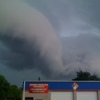
URGENT - IMMEDIATE BROADCAST REQUESTED Severe Thunderstorm Watch Number 66 NWS Storm Prediction Center Norman OK 1015 PM CDT Fri Mar 27 2020 The NWS Storm Prediction Center has issued a * Severe Thunderstorm Watch for portions of West-central Illinois East-central Missouri * Effective this Friday night and Saturday morning from 1015 PM until 400 AM CDT. * Primary threats include... Scattered large hail and isolated very large hail events to 2.5 inches in diameter possible Isolated damaging wind gusts to 60 mph possible SUMMARY...Initially elevated supercell across central Missouri should progress near the I-70 corridor with additional development possible to the east-northeast into the early morning. Large hail will be the primary hazard. The severe thunderstorm watch area is approximately along and 45 statute miles north and south of a line from 15 miles west southwest of Columbia MO to 30 miles south of Decatur IL. For a complete depiction of the watch see the associated watch outline update (WOUS64 KWNS WOU6). PRECAUTIONARY/PREPAREDNESS ACTIONS... REMEMBER...A Severe Thunderstorm Watch means conditions are favorable for severe thunderstorms in and close to the watch area. Persons in these areas should be on the lookout for threatening weather conditions and listen for later statements and possible warnings. Severe thunderstorms can and occasionally do produce tornadoes. && AVIATION...A few severe thunderstorms with hail surface and aloft to 2.5 inches. Extreme turbulence and surface wind gusts to 50 knots. A few cumulonimbi with maximum tops to 500. Mean storm motion vector 25050. ...Grams -
March 26-28 Severe Threat
WeatherMonger replied to Tim from Springfield (IL)'s topic in Lakes/Ohio Valley
Under a watch here, no watchbox by SPC available -
March 26-28 Severe Threat
WeatherMonger replied to Tim from Springfield (IL)'s topic in Lakes/Ohio Valley
ILX wanted no part of discussing it, here's DVN disco -
March 26-28 Severe Threat
WeatherMonger replied to Tim from Springfield (IL)'s topic in Lakes/Ohio Valley
Expanded the 10 and 15% hatching SW Old New -
March 26-28 Severe Threat
WeatherMonger replied to Tim from Springfield (IL)'s topic in Lakes/Ohio Valley
Reed Timmer put out this outlook map on FB -
March 26-28 Severe Threat
WeatherMonger replied to Tim from Springfield (IL)'s topic in Lakes/Ohio Valley
In a slight risk for tonight now, just inside the northern fringe as they elongated it eastward. -
Beat me to it, just got home and seen that. I know better than to get my hopes up, but 3 straight days in a Mrgl or Slight. Still haven't heard thunder this year.
-
Have a solid coating- 1/2" here in KSPI Pavement's actually coated
-
Snowing here
-
CPC still with a rather large severe area in the 8+ day range. SPC and WPC have nothing delineated in the 7-8 day range, SPC with predictability too low. New thing for CPC? Usually the delineate the SPC and WPC areas of notez but now they are going out on their own beyond warmer/colder than average.
-
Marginal risk for Thursdayfor a portion of the forum, CPC also has a pretty big area delineated just south of the region. Not yet in SPC range
-
No thunder today, onto the next one....... Can't let winter ending kill the pessimism


