

Snowstorms
-
Posts
4,126 -
Joined
Content Type
Profiles
Blogs
Forums
American Weather
Media Demo
Store
Gallery
Everything posted by Snowstorms
-

January 30-February 1 Winter Storm Part 2
Snowstorms replied to Hoosier's topic in Lakes/Ohio Valley
Latest HRRR has ~2-4" (5-10cm) for your area. But it'll be light snow over a period of 24 hours. Still though, adds to your snowpack. -
Winter 2020-21 Medium/Long Range Discussion
Snowstorms replied to Hoosier's topic in Lakes/Ohio Valley
The GFS has been advertising extreme cold all winter long beyond 300 hours but it’s never come to fruition. Although, this time around it could be legit but I'm thinking towards the Prairies. With the cold centered around SK and MB along with a weak SE ridge, February could be our biggest month if other things align. The key is blocking. It's putting a damper on the current storm track, need that to ease up. -
January 30-February 1 Winter Storm Part 2
Snowstorms replied to Hoosier's topic in Lakes/Ohio Valley
I agree. Storm is legit for Illinois and Indiana and point east including Philly, NYC and D.C. Congrats to the Chicago crew. Although, potential is there for upwards of 2-4" for parts of SEMI with this storm but it'll likely be localized. Next weekends storm is worth our attention as of now. We need a true Detroit to Toronto special like old times. -
Jan 25-26th Potential Something Part 3
Snowstorms replied to Chicago Storm's topic in Lakes/Ohio Valley
Amazing analysis, great work. The 1980's and early 90's were just bad snow wise. Primary reason why the 40-year average is 108cm. But then you got the 1970’s that were exceptionally snowy. As per your analysis, moderate-strong El Nino's and strong La Nina's are usually snowless for us. Ideally, we'd want a weak-moderate La Nina. Weak Nino's aren't bad either as per your chart but it's a mix bag. I'd reckon the 80's and 90's Nino's were bad. Aside from 2006-07 and 2009-10, all other Nino's weren't bad since 2000. Excluding 2015-16 because it was a strong El Nino. Cold neutrals just seem bad but to be fair, I don't think we've had a neutral winter since 2013-14 and before that 2012-13 and 2003-04 no? The 1980's and early 90's just seem like anomalies in an otherwise consistent trend. However, we've seen a handful of warm winters in the last 15-20 years, more than any other decade. Do you think that's the new norm or just a cycle? -
Not feeling very optimistic about this one for us. Strong blocking and lingering dry air basically shred this system as it tries to push north. Unless something drastically changes over the next 2 days, I wouldn't count on anything. Because of the block it literally moves N then E then N again. A NAO block is okay if its more towards Greenland and further east. Any block around Baffin Island is just bad all around. I’m hoping we can score something by mid Feb. The next storm is looking like a rainer for us. Congrats to the Chicago crew.
-
I agree. But there's still room for it to shift further north. A lot of moving parts for complete consensus. Like our recent storm which came surprisingly further north overtime. The two things we must monitor if we want a shift further north is the massive trough to our east and the piece of energy near Hudson Bay and its downstream impacts on our storm. The massive NAO block near Baffin Island will likely rip apart our storm, should it progress further north, limiting how much snow we can get. But I'd be okay with another 2-4" storm. Like how we nickeled and dimed our way to average last winter.
-
Jan 25-26th Potential Something Part 3
Snowstorms replied to Chicago Storm's topic in Lakes/Ohio Valley
It's kind of messy rn. I'm planning to clean it up over the next few days. I can definitely share it with you once I finish up. . Our February average has gone way up. Let's see if we continue that trend this year. Since 2011, we've averaged close to 37cm. Stealthy Toronto fashion. Has a nice ring to it. -
Jan 25-26th Potential Something Part 3
Snowstorms replied to Chicago Storm's topic in Lakes/Ohio Valley
Nah, I created a spreadsheet of every winter since records began at YYZ LOL. Re your last post. That November storm was pre sweet. Widespread 8-10". I'll be happy if we can have a 4th consecutive winter >100cm. That last time we had 4 consecutive 100cm winters was back in the 70s.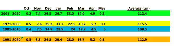
-
Jan 25-26th Potential Something Part 3
Snowstorms replied to Chicago Storm's topic in Lakes/Ohio Valley
Final total of ~3.0" at YYZ. That should bump YYZ up to 30" for the season and only 14.5" from our new (1991-2020) seasonal average. -
Jan 25-26th Potential Something Part 3
Snowstorms replied to Chicago Storm's topic in Lakes/Ohio Valley
I agree. After going nearly 4 weeks without any measurable snow, 3" feels like a lot. -
Jan 25-26th Potential Something Part 3
Snowstorms replied to Chicago Storm's topic in Lakes/Ohio Valley
+SN with visibility down to 0.2 miles at YYZ. Haven't seen heavy snow like this since Jan 2019. -
Jan 25-26th Potential Something Part 3
Snowstorms replied to Chicago Storm's topic in Lakes/Ohio Valley
SN with visibility down to 0.4 miles at YYZ. Can't tell if that's a dry slot near Hamilton. -
Jan 25-26th Potential Something Part 3
Snowstorms replied to Chicago Storm's topic in Lakes/Ohio Valley
Radar returns look impressive especially around Kitchener. Most of our snow should fall within 2-3 hours. We could approach 3-6cm/hr rates. It’ll be nice. YYZ's new snowfall average for 1991-2020 will be ~113cm (44.4"). Our previous average was 108.5cm (42.7"). -
Jan 24-26th Potential Something Part 2
Snowstorms replied to Chicago Storm's topic in Lakes/Ohio Valley
EC has issued a snowfall warning for Halton-Peel only. Up to 15cm (6") possible. -
Jan 24-26th Potential Something Part 2
Snowstorms replied to Chicago Storm's topic in Lakes/Ohio Valley
Okay makes sense. Thank you for the breakdown. Not super knowledgeable when it comes to lake effect, so thanks for the insight. Should be a good event nonetheless and should help YYZ inch closer to average. -
Should be from someone who's done good this season. That's the real good luck. So, anyone from parts of Michigan, NE Ohio, Iowa or Southern Ontario.
-
Jan 24-26th Potential Something Part 2
Snowstorms replied to Chicago Storm's topic in Lakes/Ohio Valley
I've noticed these type of deformation bands always set-up away from the Lake especially north of 401. Thermals look good for some decent dendrites too. What's your take on any potential lake enhancement? -
I was never good at biology in school haha. Perhaps I'll message you come spring when I do my spring gardening. I work in Finance and Accounting. I graduated from school back in 2017 and now I’m working towards my CFA designation. Though it’s been delayed right now because of Covid. I've always been interested in weather since I was a kid. It’s always been a passionate hobby for me. I just couldn't see myself working as a meteorologist though. However, I spend time learning more and more about weather every day because I find it interesting. I also find learning about space interesting too.
-
Jan 24-26th Potential Something Part 2
Snowstorms replied to Chicago Storm's topic in Lakes/Ohio Valley
HRDPS is bullish for the GTA tomorrow. If that FGEN band materializes as shown on the models, there could be an intense burst of +SN for 2 hours tomorrow morning. Wouldn't be surprised to see 4-6"+ tomorrow. -
Winter 2020-21 Medium/Long Range Discussion
Snowstorms replied to Hoosier's topic in Lakes/Ohio Valley
@StormfanaticInd + other Indy posters death band.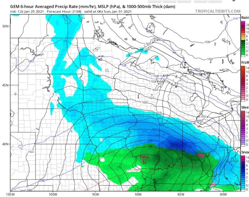
-
Jan 24-26th Potential Something Part 2
Snowstorms replied to Chicago Storm's topic in Lakes/Ohio Valley
In under 3 minutes too eh? Nice -
Jan 24-26th Potential Something Part 2
Snowstorms replied to Chicago Storm's topic in Lakes/Ohio Valley
That's pretty crazy. How much do they normally average per winter? -
Winter 2020-21 Medium/Long Range Discussion
Snowstorms replied to Hoosier's topic in Lakes/Ohio Valley
I agree. It's interesting to say the least. Only thing I’m concerned about is the progressive flow. The northern stream doesn’t really dig further south and like our current storm, it’s all southern stream. Nonetheless, it could be a decent overrunning event with some STJ influence too. We’ll know more as the week progresses and when it’s sampled come Thursday night. -
Jan 24-26th Potential Something Part 2
Snowstorms replied to Chicago Storm's topic in Lakes/Ohio Valley
I agree. Most of the snow should fall within a few hours with the leading FGEN band. Looks favorable for some good dendrites too. Could be some lake enhancement from Mississauga to Oakville. After such a quiet and boring month, even 4” will feel like a winter wonderland. Nice to see you back again. -
Jan 24-26th Potential Something Part 2
Snowstorms replied to Chicago Storm's topic in Lakes/Ohio Valley
For the GTA, it doesn't look anything exceptional like you guys in IA and IL. Have fun! Looking at the 3KM NAM, most of the snow should fall in a relatively short time frame along a fast moving FGEN band. The storm begins weakening rapidly as it move towards our area, so that FGEN band is our only window of opportunity. Potential is there for some lake enhancement but more towards Oakville-Hamilton. I'd go with 1-2" for Toronto proper, for now.

