forkyfork
-
Posts
30,804 -
Joined
-
Last visited
Content Type
Profiles
Blogs
Forums
American Weather
Media Demo
Store
Gallery
Everything posted by forkyfork
-
3/7/18 was another pretty far west miller b
-

December 2020 General Discussions & Observations Thread
forkyfork replied to bluewave's topic in New York City Metro
why not -
December 2020 General Discussions & Observations Thread
forkyfork replied to bluewave's topic in New York City Metro
i've seen worse patterns -
once you guys free yourselves from the ptype prison you will attain peace
-
December 2020 General Discussions & Observations Thread
forkyfork replied to bluewave's topic in New York City Metro
wow i had no idea you wanted it to snow more -
December 2020 General Discussions & Observations Thread
forkyfork replied to bluewave's topic in New York City Metro
there was a SSW in jan 2012 too... -
December 2020 General Discussions & Observations Thread
forkyfork replied to bluewave's topic in New York City Metro
that's barely a -nao. the ridging is focused in western russia/eastern europe -
@Juliancolton omg!
-
December 2020 General Discussions & Observations Thread
forkyfork replied to bluewave's topic in New York City Metro
a lot of us got a 40+ winter in 2018 -
December 2020 General Discussions & Observations Thread
forkyfork replied to bluewave's topic in New York City Metro
you had one two years ago -
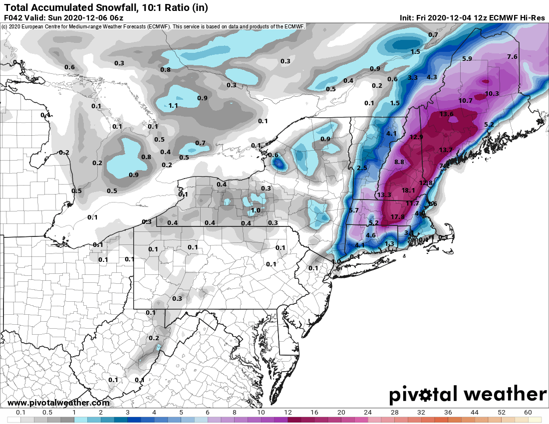
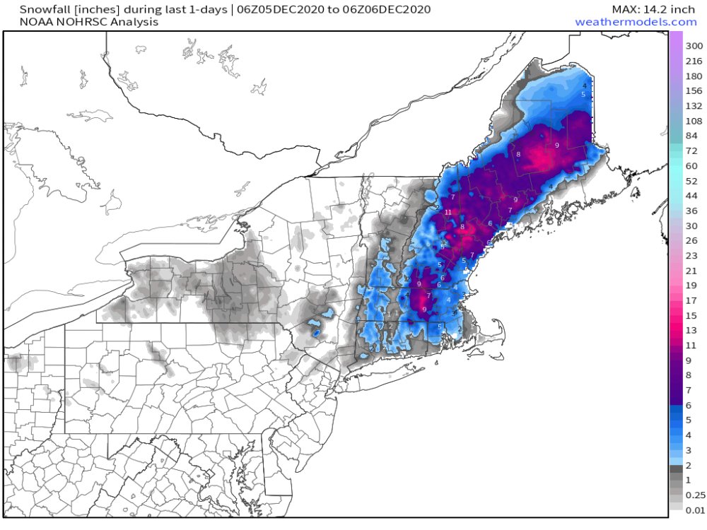
model snow maps are dumb part 854

- 373 replies
-
- 2
-

-
- heavy rain
- wind event
- (and 2 more)
-
would have been a foot+ easily with even a seasonable airmass. too bad so sad
- 373 replies
-
- 2
-

-

-
- heavy rain
- wind event
- (and 2 more)
-
maybe we can get our first winter with 0"
-
and you're not
- 373 replies
-
- 3
-

-
-
- heavy rain
- wind event
- (and 2 more)
-
duh
- 373 replies
-
- 3
-
-
-
- heavy rain
- wind event
- (and 2 more)
-
i hope the cold pattern verifies and we get a bunch of big threats that fall apart at the last minute
-
someone who tells the truth about turkey
-
December 2020 General Discussions & Observations Thread
forkyfork replied to bluewave's topic in New York City Metro
we need a well timed phase to overcome a crappy airmass well away from peak climo. gl -
December 2020 General Discussions & Observations Thread
forkyfork replied to bluewave's topic in New York City Metro
no snow for you -
Tracking The 3”+ Heavy Rainfall Events Since 2010
forkyfork replied to bluewave's topic in New York City Metro
...ORANGE COUNTY... OTISVILLE 3.14 IN 0940 PM 11/30 NYSM https://nwschat.weather.gov/p.php?pid=202012010318-KOKX-NOUS41-PNSOKX -
November 2020 General Discussions & Observations Thread
forkyfork replied to Rtd208's topic in New York City Metro
there are better options than an invasive species that splits apart easily