

buckeye
-
Posts
8,860 -
Joined
Content Type
Profiles
Blogs
Forums
American Weather
Media Demo
Store
Gallery
Everything posted by buckeye
-
yep, might as well throw i-95 in there. Lot of potential for those folks with this set up. Meanwhile we continue to watch snow chances like we're watching a tennis match smoking cirrus.
-
maybe we should be rooting for this to keep diving in further west to give it enough space and time to allow the piece behind it to phase in. Meanwhile the northeast confluence weakens, the SER flexes, the trough goes negative over the gulf states, and a monster emerges. Although what would actually happen is another MECS.
-
I choose the ggem this round. Also the gefs is much further east then the gfs op. There's my glass half full. Pondo gonna be proud of me
-

Winter 2021-22 Short/Medium Range Discussion
buckeye replied to Chicago Storm's topic in Lakes/Ohio Valley
can we split the difference? -
Winter 2021-22 Short/Medium Range Discussion
buckeye replied to Chicago Storm's topic in Lakes/Ohio Valley
Welcome back! It's great to have a met in the forum that does thorough long range discussions for our area. Always look forward to your analysis even when the news sucks. -
Good point, maybe they're just on the endangered list like clippers. Actually, I wonder when the last true triple phaser occurred over the conus.
-
lol
-
Ganahl is a snow weenie, I even think Gelber is too. But I think these OCMs feel an obligation to publically project the 'negative' side of weather. After all, only weenies like us consider a 2' blizzard the utopia of winter.
-
For me, there's about 5 weeks left before I start hoping for warmth vs. snow. When it comes to March, go '08 or go home.
-
Man that's brutal stuff. On the bright side, indices look more favorable with -ao coming up and mjo looking to move out of 7 through possible the cold phases. Regardless, I think any snow events are going to be a result of perfect timing and luck instead of being a result of a wintry pattern setting in for weeks. This might be one of those winters defined by one event, especially if we can luck out with perfect timing and be on the snowy side of a tripple-phaser . We're due.
-
I wish
-
I think nam was a head fake. So far from what I've seen this morning, the upper lakes low is a bit stronger so it's flattening heights out in front. The storm is not able to deepen as much and come as far north as we need. Still have the gfs and euro but not holding my breath on this one.
-
yea it did
-
Winter 2021-22 Short/Medium Range Discussion
buckeye replied to Chicago Storm's topic in Lakes/Ohio Valley
I guess the only way not to be an outcast is to give right back to y'all. But I have a feeling the butt-hurt screams would be deafening. 29 posts. You haven't earned a reply, (just joking) -
Winter 2021-22 Short/Medium Range Discussion
buckeye replied to Chicago Storm's topic in Lakes/Ohio Valley
My point is geography, yours is, "but someone else is doing it...". But I know there was another reason why us Ohioans don't like participating in the main threads....hmmmm....what was it again?.... ...oh that's right, the weird hardon and snark that some of you have for Ohio posters. -
I suspect the NAM is going to double down on it's 12z. Looking at the 18z sref it actually has the greatest precip amount to our nw
-
On the bright side, sometimes when models are dealing with two waves close to one another, surprises can happen quickly with the second one. There's my happy weenie injection for the day
-
Slowly losing the euro as this thing sinks south. Now watch the GFS come back tonight with a block buster storm for us

-
Yep, big red flag. Really the only good run so far has been the nam +60 hrs. Not encouraging. GEM trended weaker and south, icon is nada, gfs is nada, ukmet was showing hope at 00z but it went back to crap at 12z. If I were a betting man I'd have to put my chips on the euro starting to cave at 12z. If not, then we can at least hug the ole EE rule. Regardless,after that it's a rainstorm followed by a sharp cold front that is transient. In this wavy pattern it's all about luck and timing. DC has the hot ticket right now.
-
Trust me, I'd love to choke down crow on this one. I'm ready for some snow.
-
I hate to say it but the gfs seems to make more sense to me. That first storm in front of it moving through the upper lakes delivers the cold, but the spacing might not be enough to allow the follow up energy to amp much.... IOW, washed-out turd. This may not even be a matter of the gfs and euro meeting halfway, probably one is going to score the coupe. Gfs scored the coupe on the MA storm, so there's that too unfortunately.
-
Winter 2021-22 Short/Medium Range Discussion
buckeye replied to Chicago Storm's topic in Lakes/Ohio Valley
Yea, it's a head scratcher, can't understand why.
-
Winter 2021-22 Short/Medium Range Discussion
buckeye replied to Chicago Storm's topic in Lakes/Ohio Valley
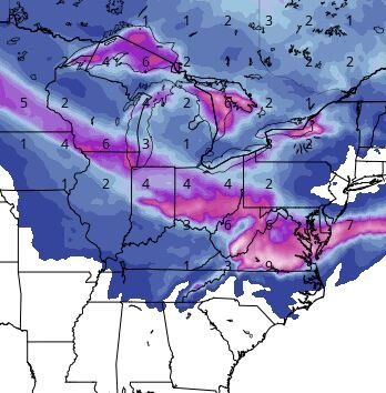
ugh, the gfs was a nightmare for those of us south of i80. Back to back rainstorms with postfrontal flurries in between. Saving grace is it's the gfs longrange OP. Canadian is more 'rainy' looking with it's threats inside 240 hrs. Either way I'm getting a sinking feeling about January. MJO stuck in 7, pna stuck negative, ao and nao heading back up. Every threat and significant cold shot in the longterm either pushes back or becomes muted. It seems winter cant get sustained in the east as troughs move in and out and the SER keeps fighting back. Last year we had a sucky January and a flip in Feb. This year just has that 11'-12' stank to it. I remember January was boring as hell and pretty much every met, (except for Don S.), was touting a flip to cold that kept getting pushed back and eventually never came. If this January is a yawner I think there's a greater chance of a Feb/March warm up vs. a flip to colder. Nothing meterological....just a pessimistic feeling. oh, and Merry Christmas! -
Winter 2021-22 Short/Medium Range Discussion
buckeye replied to Chicago Storm's topic in Lakes/Ohio Valley
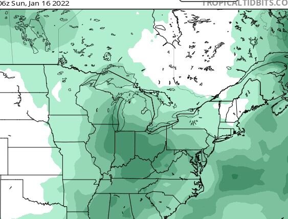
If you're north of i-80 you may have a chance next week of 'something' frozen. Down here in the I-70 corridor....we're fked. The set up seems to be one that if a wave stays just a wave you have a chance. If it becomes something stronger it's cutsville. -
Yes! probably my favorite Christmas storm even though it occurred a week before. Where it stayed all snow in western Ohio and eastern IN, as you said, you guys got clobbered. I think there were totals above 30" in some places if not close to 40". We received 7" of snow followed by about .5" of ice. Got very cold following the storm right through Christmas. Between the snow and the ice-covered landscape, it was an amazing scene.


