

buckeye
-
Posts
8,861 -
Joined
Content Type
Profiles
Blogs
Forums
American Weather
Media Demo
Store
Gallery
Everything posted by buckeye
-
How's that been trending?
-
Manitoba Mauler?
-
I'll be sleeping very lightly with my radar handy on my phone and this forum open. Looks like timeline is between 1 and 4 am for the change from liquid to frozen, then the million dollar question is when the frozen turns to flakes. I've seen some models have it as early as 5am and of course we have the rgem that really never changes over to all snow until evening. If it's snowing at 6am, we'll be in very good shape.
-
same, just doesn't want to change to snow....perpetual sleet/frz rain. Rgem is usually a decent short range model but can definitely have a warm bias in the very near term....hoping that's the issue
-
I still feel pretty good but I'd feel better if the rgem starts to play ball at 00z
-
As we get closer they widen the uncertainty, maybe they should go 1-8 and give themselves a 90% chance of hitting the mark.
-
that's terrible. Thanks for the update, I had a hunch it was covid and maybe they were removed from the ventilators at the same time.
-
Even the trash HRRR is a big improvement. I don't think we'll have a handle on snow vs. ice until tonight when the first overrunning slug runs through and we can see where the front makes it to for the wave following it. I've noticed there is more and more of a lull in precip showing up between the first and second wave, that lull might allow the cold air to progress a little more southeast.
-
Thanks
-
Who has a link for a good precip-type radar?
-
It's not really about incoming warm air, it's about dislodging warm air with Arctic air. The shallow air is going to cool quickly while the upper layers will take more time. That's why we have the ice threat. It's such a thread the needle situation where we are located. The overrunning further north is easy. It's what happens after that, that gets convoluted.
-
Pretty much
-
It's all good. This debate about splitting off the sub comes up every year. This sub is definitely Chicago to lower Michigan centric.
-
Gotcha KY and Minnesota are in our forum too, lol.
-
Tsun?
-
Not much. I think rgem is going to be an improvement....hard to tell on the crappy black and white maps.
-
I wouldn't take the hrrr seriously until later tomorrow. The extended hrrr is trash.
-
Then we should. No offense to anyone in the sub but this storm is the perfect example of why we should be separate. Chicago and MI posters are rooting for opposite trends as us. We all want to post info that bolsters the outcome we want. So it turns into a pissing match of "this model went south...that model went north...this model is trash...that model does the best"...etc. It's like being part of a sports forum and fans from two teams playing each other are posting in the same thread. Nothing good comes from it and it always turns into a pissing match.
-
I flipped through the 500mb first and all features were slightly, but clearly southeast of 18z and yet the surface features were pretty much the same. I don't think the nam has the answer yet
-
Yea, I looked at tt and the mix line is a tad further north. Looked better on stormvista
-
can't wait until tomorrow when the radars are fired up and we start dissecting every hrrr run. You guys remember that one 2 years ago in January. Started off as rain and sleet and was suppose to changeover but it took hours longer than expected. The local meterologists caught all kinds of hell.
-
appears gfs not budging....if anything possible a tick southeast
-
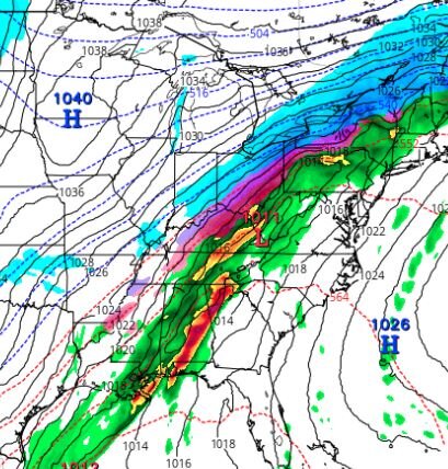
So according to the rgem we have a 1040 high centered in southern MN, and a 1011 wave in southern WV. If someone asked me what that means for us, I'd say we'd be smoking cirrus.... and yet... we're getting an icestorm.
-
....well I guess we do need someone to cover the pessimism flank. I'm trying to hold on the the optism flank.
-
I still feel more like this will go in our favor once the changeover hits. The low on the nam travels just south of the Ohio river thru WV. That's not a bad track and the fact that it's a relatively weak low/strong wave, I don't see a ton of warm air being drawn north. Still have the high building in as well. What makes this tough is we are so close to the goods that real time, small, nuances could effect outcome big time. Stuff like convection in the south and intensity of precip. I also think how much of a break in precip between the two shots will have an effect on cold air progression. So to sum up....i have no f'ing clue other then to say I've seen these situation end up both good and bad.


