buckeye
-
Posts
8,860 -
Joined
Content Type
Profiles
Blogs
Forums
American Weather
Media Demo
Store
Gallery
Everything posted by buckeye
-

Winter 2022/23 Medium/Long Range Discussion
buckeye replied to Chicago Storm's topic in Lakes/Ohio Valley
and it’s not like we’re south of you either… -
Late February will be rocking. February Long range Discussion thread
buckeye replied to Ji's topic in Mid Atlantic
he said he nailed it at 10mb -
Ahhh yes, the sswe, aka the last vestige of a weenie
-
Officially hit 70 today at the airport. Impressive. by the way, @michsnowfreak , the first step is acceptance.
-
2023 Short/Medium Range Severe Weather Discussion
buckeye replied to Chicago Storm's topic in Lakes/Ohio Valley
first high wind warning that actually was warranted here. The steel and glass door to my office just blew open....scared the crap out of me. -
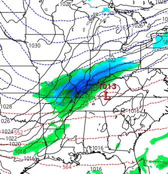
This is an example from the 12z gfs. It seems with storms this winter, the cold sector precip shield almost always has rain outside the heaviest precip band, (even on the nw flanks). I don't recall seeing this in past winters on models, at least no where near as prevalent.
-
Never underestimate the ability for CMH to pile up enough March and April car-toppers and single-day-slush-melts to bring us up to average leaving us scratching our heads wondering how the hell we got there. BTW, looks like it's gonna be a bit breezy tomorrow.
-
the only 2 hours that it was cloudy at least had rainbow with it

-
ugh, from 84 degrees, blue skies, soft breeze, and sipping away my days with mojitos and rum and cokes....to this craptastic 35 degrees, gray, and slushy slop piles. Well at least I have a nice tan lol. Next week kinda looks interesting depending on where that boundary settles in... icestorm anyone?
-
thanks! 6 days of 'forget about life for awhile'. Coming back to snow or something to track would take the edge off returning to our usual depressing climo. So let's see what you guys can do to make that happen . Maybe find where Josh's magnet went, clearly he's misplaced it.
-
My snowblower is still sitting in the back of the garage with a flat tire. The thing is a monster, more suitable for Buffalo then CMH but I got it super cheap brand new, ($168.00 a couple of summers ago). I was going to pull it out for the xmas eve snow but it was too damn cold and snow was like dry sand anyways. I'm heading for the carribean for a short vacation...hopefully something delivers on Sunday so I come back to snow followed by another storm on our doorstep later in the week. Truth be told, I'm worried next week's snow and turn to cold might be another headfake....just another batch of weakening lows and cold starved systems....hope not. The gfs is a dumpster fire but the euro is
-
Nothing like a late March/ early April trash storm in the heart of winter.
-
Frigid Weather Not For TheBirds!
buckeye replied to MrsH's topic in Weather Forecasting and Discussion
Interesting. I live in Central Ohio and late afternoon on the 23rd, after we had received 4.5" of snow, the temp was -8 and the windchill was in the stupid range. My wife was in the kitchen and I heard her scream. She said she opened the basement door and there was a 'big bird' in the stairwell. After getting the nerve to investigate, (yea i admit I'm not a fan of birds, bats, etc.), I went down in the basement and there was like 8 of them perched on the water pipes and flying around. They weren't small birds either. We have glass block basement windows but thankfully I can open a small section in each window. We blocked all the light in the basement except for one window and managed to scare and shoo them out one at a time. I've lived in this house for nearly 30 years and we've never had a bird in the house. I have no idea how they got in....which is the worst part of this. Best I can assume is they came in through the chimney and possibly in opening somewhere inside the wall or chimney itself. However they got in, it was pure desperation and survival on their part. -
eerily still. Windows frosted over. Now it looks like we don’t break 0 degrees today
-
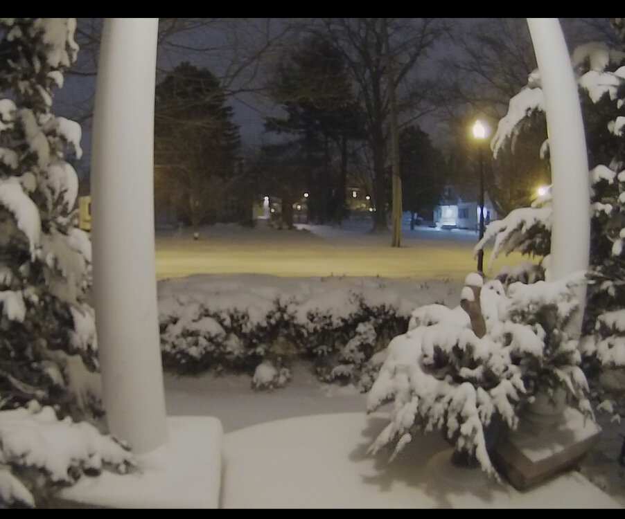
Wow we did better then expected, maybe like 4”? All calm fresh powder. -4. Ready for the ground blizzard
-
I went out a little earlier, it's a steady heavy mist/drizzle, low clouds, dismal and in the 40's. Kinda reminds me of that benign afternoon of Wednesday January 25th, 1978. In all seriousness I do think we are looking a little better here in central OH. It seems there's been a slight trend east with everything and I've seen some short model runs that give us more precip then places west. Not saying it's going to be heavy snow but I think we have a better shot of 3" + then it looked like yesterday.
-
Pre-Christmas (Dec 21-23rd) Winter Storm Part 2
buckeye replied to Chicago Storm's topic in Lakes/Ohio Valley
My sister and brother-in-law built a new house east of lakewood, OH. The back of their house is about 70' from the shoreline of lake erie. Needless to say the house will be tested tomorrow -
well all that's left is to fire up the radar and the meso models, kick back a few and make sure I'm up at 2am to watch this front come thru. Media is calling this a "once in a generation weather front"....may it live up to the hype and bring us more surprise then disappointment
-
This might be the first time no one has been nam'd during a forecast cycle leading to a storm. Fully expected that at some point it would be showing a 950 low over cleveland
-
that screw zone through central OH has been showing up to some degree or another on several models. I realize that is the infamous "scioto river valley" that can screw us by trapping in warm air or helping to funnel in warm tongues but neither of those should be an issue with this set up. Oh well, with strong winds out of the nw maybe we can steal some snow from the Findlay area. I'm going with 1-12" and I realize measuring will be virtually impossible so you'll just have to trust me when I report my final obs
-
Pre-Christmas (Dec 21-23rd) Winter Storm Part 2
buckeye replied to Chicago Storm's topic in Lakes/Ohio Valley
Voice of reason…/\ -
Shape of trough, speed of front, where/when do the low(s) develop on it, how do all the pieces of energy interact. Give it 24 hours.
-
meh, it's been awhile since we've had a good ole fashioned asphalt blizzard.
-
sorry for the weenie blasphemy, (and maybe it's just my age), but /\ that's going to feel sooo good
-
I can definitely agree with that. The wind factor is a big question mark. A handle on that won't be known until the system is getting underway.