

buckeye
-
Posts
8,860 -
Joined
Content Type
Profiles
Blogs
Forums
American Weather
Media Demo
Store
Gallery
Everything posted by buckeye
-

Winter 2023/24 Medium/Long Range Discussion
buckeye replied to Chicago Storm's topic in Lakes/Ohio Valley

-
Trolling in favor of warmth is sacrilege around these parts... Change your name to frozenpalmguy and post like Jebman and you'll be the Belle of the Ball!
-
well we all got teased on this one..... there were a few model runs that were even burying us on the southern flanks of the sub.
-
My favorite days of wx board was back in the early 2000s with Wrightwx and Euswx. That was the wild west with no borders or sheriffs to be found. Being able to troll DT, HM, and LC was priceless. btw IWX, I like this thread title, it's good to know there's finally a place to piss here!
-
we already have 48" and it's still late fall
-
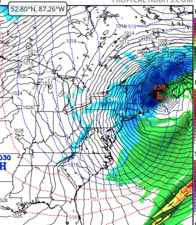
its gfs long range silliness....but that would be one hell of a storm. 938 low is basically a snowicane
-
I wonder what the windchill is for 13 degrees with 150mph winds
-
Although I'm fine with this outcome before the holidays, I hope it's not a trend for the winter.
-
30 years ago
-
Fall 2023 Medium/Long Range Discussion
buckeye replied to Chicago Storm's topic in Lakes/Ohio Valley
Looks like our cold source regions are on fire. I'm all for torching until xmas.... Also some support with the mjo charging forward into the warm phases -
there's nothing like a boost of optimism with my morning coffee
-
Let’s talk winter!! Ohio and surrounding states!!
buckeye replied to Steve's topic in Lakes/Ohio Valley
Ready to Roast!
- 144 replies
-
- 14
-

-

-

-
When did you move to Columbus?
-
suppressed juiced up track..... big midatlantic winter?
-
and yet the 500mb anom looks troughy in east and ridgy in west. So if that still happens and we end up with this /\, we might as well close the blinds and find a new hobby.
-
I love snow....because it's snow. Covering my yard and house in frozen water mist from a hose, when there's bare ground everywhere else, would be just an added hassel in my life.
-
same here btw I wonder how cold it has to get before TWC breaks out the light blue crayons.
-
Remember that summer very well. I was working near Cincinnati and remember the rule of thumb was if it hit 94 by noon it was going to be a 100+ day. It happened a lot that summer. Also the first time I recall people losing their entire lawns, (not dormant but actually killed off). Many people had to have them re-seeded, sodded. On separate note, that was also the first time I felt an earthquake....it was later during that same summer.
-
2023 Short/Medium Range Severe Weather Discussion
buckeye replied to Chicago Storm's topic in Lakes/Ohio Valley
June 14, 1990 Shadyside, Ohio….still remember that one -
Jel.... viewing the northern lights are definitely on my bucket list!
-
Spring 2023 Medium/Long Range Discussion
buckeye replied to Chicago Storm's topic in Lakes/Ohio Valley
I'm in -
Spring 2023 Medium/Long Range Discussion
buckeye replied to Chicago Storm's topic in Lakes/Ohio Valley
...he nervously asked as beads of sweat formed on his brow... -
… so let me get this straight. Wanting a white Xmas and an early end to winter is nonsensical while a fascination for March and April snows is perfectly logical. I hate to tell you this, but you’re the one on the side of crazy.
-
Spring 2023 Medium/Long Range Discussion
buckeye replied to Chicago Storm's topic in Lakes/Ohio Valley
snow after mid march is about as exciting as having sex with a leather condom -
Ah yes, the very common CMH-PIT-DCA special.


