

buckeye
-
Posts
8,844 -
Joined
Content Type
Profiles
Blogs
Forums
American Weather
Media Demo
Store
Gallery
Everything posted by buckeye
-

Let’s talk winter!! Ohio and surrounding states!!
buckeye replied to Steve's topic in Lakes/Ohio Valley
It's incredible, the second one might go ever further NW! BTW, I admire you guys, we're only on page 2 of our winter thread while you guys have about 350 pages in medium to long range threads starting at the end of OCT. Almost every LR ensemble, and euro weekly that comes out has been analyzed as 'drool worthy'. How's that been working out for ya? -
Let’s talk winter!! Ohio and surrounding states!!
buckeye replied to Steve's topic in Lakes/Ohio Valley
So we couldn't buy a sub 980 low tracking through our sub the last several winters.....now the 18z gfs has TWO sub 980 lows not only tracking through the region but taking an almost identical track 72 hrs apart. ok I guess anything is possible and the most believable part of it is that CMH is on the warm side of both. Actually I still think the weekend storm isn't set in stone yet.... but I've been wrong before. -
Let’s talk winter!! Ohio and surrounding states!!
buckeye replied to Steve's topic in Lakes/Ohio Valley
GFS wants to take 3 storms almost the same path just over us or slightly west of us, doubt that happens. I think the only sure bet is Tuesday is a rainer. I'm not sold that the follow up storm for next weekend is nw of us. Lots of spread on the ensembles with some pretty far southeast. It's all about spacing and interaction with the northern stream....those won't be ironed out until the Tuesday storm plays out. All that said, this is probably the best opportunity for sig snow coming up that we've seen in awhile even though it'll probably be tainted. -
I think if you're going to be completely honest, you have to admit that if his schtick was cold bias vs. warm bias, (ie Jebman), and all other things were identical with his posting style, he would not have been banned.
-
A snow removable business in Columbus Ohio is a huge gamble. In the UP of Michigan it shouldn't be.
-
Winter 2023/24 Medium/Long Range Discussion
buckeye replied to Chicago Storm's topic in Lakes/Ohio Valley
Tons of talk about an SSWE... ...never a good sign -
Winter 2023/24 Medium/Long Range Discussion
buckeye replied to Chicago Storm's topic in Lakes/Ohio Valley
is there any similarities to 97-98? Fast flow and cut off lows, an early January brief cold spell followed by seasonable boring weather and an eventual crazy cutoff low that snowed in the south and rained in the north. -
Let’s talk winter!! Ohio and surrounding states!!
buckeye replied to Steve's topic in Lakes/Ohio Valley
I can’t put my finger on it but there’s something very believable about this… -
Good to see others crossing over to the 'gray' side. I'll always love extreme weather, especially winter storms, but as I get older I have more and more disdain for the cold.
-
Winter 2023/24 Medium/Long Range Discussion
buckeye replied to Chicago Storm's topic in Lakes/Ohio Valley

-
Trolling in favor of warmth is sacrilege around these parts... Change your name to frozenpalmguy and post like Jebman and you'll be the Belle of the Ball!
-
well we all got teased on this one..... there were a few model runs that were even burying us on the southern flanks of the sub.
-
My favorite days of wx board was back in the early 2000s with Wrightwx and Euswx. That was the wild west with no borders or sheriffs to be found. Being able to troll DT, HM, and LC was priceless. btw IWX, I like this thread title, it's good to know there's finally a place to piss here!
-
we already have 48" and it's still late fall
-
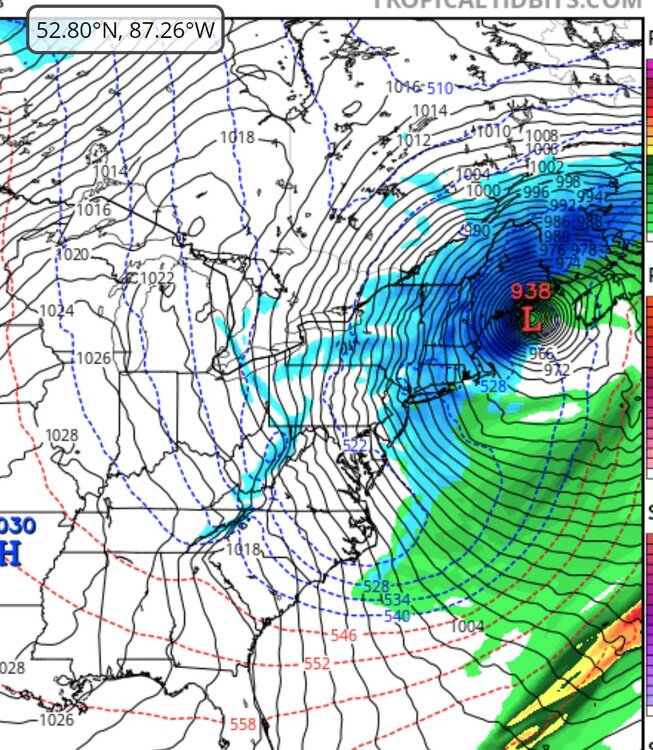
its gfs long range silliness....but that would be one hell of a storm. 938 low is basically a snowicane
-
I wonder what the windchill is for 13 degrees with 150mph winds
-
Although I'm fine with this outcome before the holidays, I hope it's not a trend for the winter.
-
30 years ago
-
Fall 2023 Medium/Long Range Discussion
buckeye replied to Chicago Storm's topic in Lakes/Ohio Valley
Looks like our cold source regions are on fire. I'm all for torching until xmas.... Also some support with the mjo charging forward into the warm phases -
there's nothing like a boost of optimism with my morning coffee
-
Let’s talk winter!! Ohio and surrounding states!!
buckeye replied to Steve's topic in Lakes/Ohio Valley
Ready to Roast!
- 144 replies
-
- 14
-

-

-

-
When did you move to Columbus?
-
suppressed juiced up track..... big midatlantic winter?
-
and yet the 500mb anom looks troughy in east and ridgy in west. So if that still happens and we end up with this /\, we might as well close the blinds and find a new hobby.
-
I love snow....because it's snow. Covering my yard and house in frozen water mist from a hose, when there's bare ground everywhere else, would be just an added hassel in my life.

