Radtechwxman
-
Posts
2,481 -
Joined
-
Last visited
Content Type
Profiles
Blogs
Forums
American Weather
Media Demo
Store
Gallery
Everything posted by Radtechwxman
-
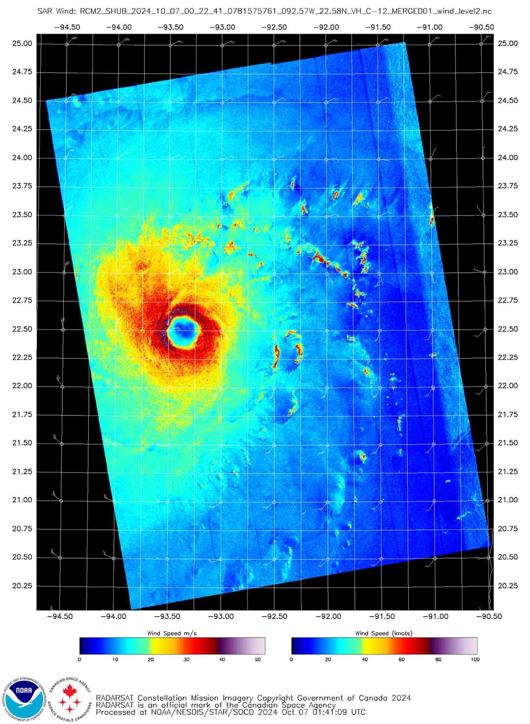
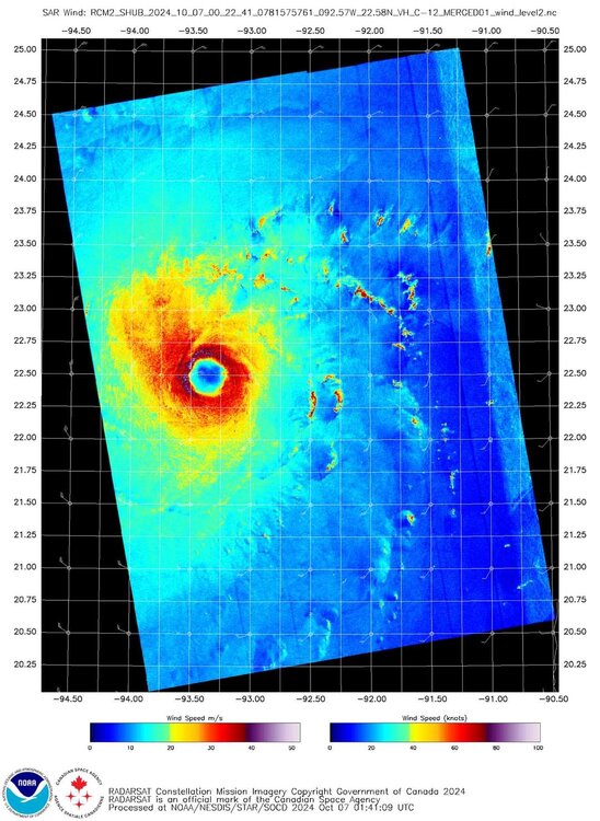
125mph 950mb as of latest update
-
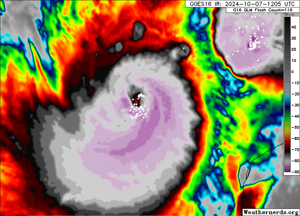
Maybe a little of both. But IR appearance is improving and lightning has upticked.
-
Eyewall definitely has improved on radar. Less open and looks like the concentric eyewalls have combined or close to.
-
Looks like Milton is bare minimum cat 4 now on latest update. 130 mph 944mb. I'm thinking it may landfall as low end 3 unless it restrengthens later but probably unlikely given satellite/radar presentation.
-
Lightning is still very prolific in the eyewall. Typically don't see that with weakening storms. I haven't seen this much eyewall lightning since Dorian.
-
Definitely perplexed why we don't have higher winds right now. That's insane
-
I knew EWRC would take its toll but didn't expect it back down to cat 4 already albeit just barely. Satellite appearance has definitely degraded compared to earlier. Curious to see if there's any recovery tomorrow after it completes EWRC.
-
That motion on radar really looks like part of eyewall could come on shore in Yucatan. Curious to see what effect this has on Milton.
-
Incredible amount of eyewall lightning
-
Wonder if interaction with Yucatan will disrupt COC and cause dry air entrainment since it's a smaller storm. However it's a very well put together storm compared to Helene at the point it would interact with Yucatan.
-
Hence why I'm confused why recon was finding steady pressures before they left
-
I'm really surprised at that given how the IR satellite appearance continues to improve and eye about to pop
-
Surprised nhc is being more conservative with top strength Milton reaches in Gulf esp given how it looks tonight. I think 150-155 is a good bet and likely higher if good organization remains next day or so while Milton remains in favorable low shear and high OHC.
-
Impressive microwave pass
-
Yeah I have a habit of doing that. Ha. But thanks for the input
-
I'm not but doesn't mean I'm not educated on hurricanes. I understand land friction and you don't see same winds as over water. But also typically with a cat 4 you will see higher sustained winds and much higher gusts. But also I don't think there's a lot of recording stations capturing that so could be missed. I just found it interesting pressure was dropping till LF but we did see clouds warm on satellite esp in NE quadrant and wonder if something meteorologically was going on. Not properly mixing down winds, something like that.
-
Not what we're saying at all. Not expecting 140mph winds at all. But one would expect sustained winds near or over 100mph with some gusts of 120+. Perry gusted to 99mph. I would have thought sustained winds would be closer to that. Just seems underwhelming.
-
Videos definitely seem tame for a 140 cat 4 storm. But like people said could be issue of chasers not being where best winds were. Not many locations to safely intercept down there. Something I did notice though on satellite is that cloud tops warmed a lot in ne quadrant at landfall but stayed very cold in western eyewall. Wonder if better winds will end up being west which is atypical.
-
Per NHC: so kind of confused why they didn't go higher if they felt it was conservative Peak 700 mb flight-level winds from the aircraft were 136 kt, corresponding to an intensity of about 120 kt, which might be a bit conservative. Radar and satellite images show numerous mesocyclones rotating around the eyewall.
-
Surprised winds didn't come up from 140 with these pressure drops
-
East side? No way. West side yes
-
Think we see winds come up again before landfall or it holds steady?
-
Anyone got a VDM from hurricane hunters currently?
-
Man that's going to be a wild ride. You live there or chasing?
-
Lol. Oops. I was thinking in the hurricane. My bad