CoraopolisWx
-
Posts
2,960 -
Joined
-
Last visited
Content Type
Profiles
Blogs
Forums
American Weather
Media Demo
Store
Gallery
Everything posted by CoraopolisWx
-

Western PA/Pittsburgh Fall Weather Discussion
CoraopolisWx replied to Ahoff's topic in Upstate New York/Pennsylvania
Seems about right for most of us. Euro is a bit more robust with the WAA precip Sat. night, but nothing major. -
Western PA/Pittsburgh Fall Weather Discussion
CoraopolisWx replied to Ahoff's topic in Upstate New York/Pennsylvania
https://www.farmersalmanac.com/weather-by-caterpillar-486 -
Western PA/Pittsburgh Fall Weather Discussion
CoraopolisWx replied to Ahoff's topic in Upstate New York/Pennsylvania
https://go.usa.gov/xM5KV -
Western PA/Pittsburgh Summer Discussion 2021
CoraopolisWx replied to Ahoff's topic in Upstate New York/Pennsylvania
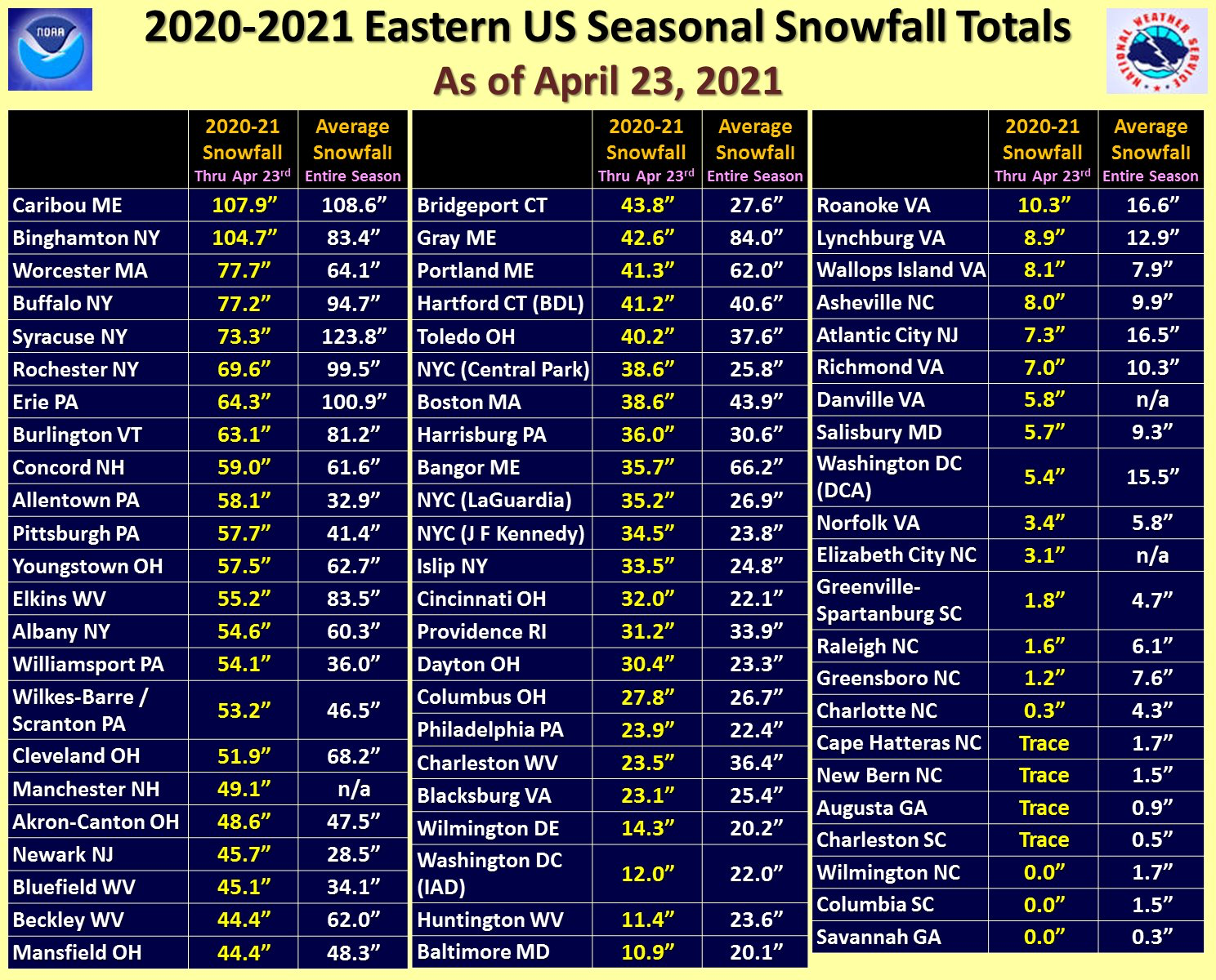
A belated 2020-2021 snowfall totals.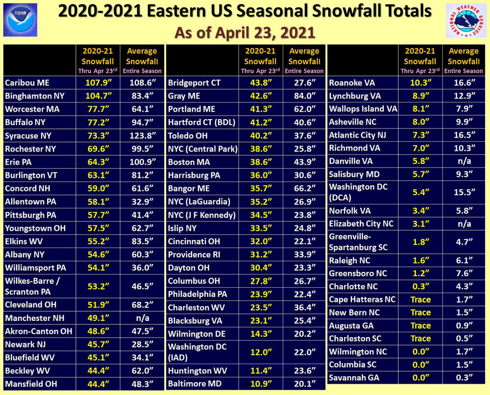
-
Posting in the newer thread.
-
Western PA/Pittsburgh Spring Discussion 2021
CoraopolisWx replied to Ahoff's topic in Upstate New York/Pennsylvania
Looking at the traffic cams, the solid accumulation has been mostly above 1100ft. -
Western PA/Pittsburgh Spring Discussion 2021
CoraopolisWx replied to Ahoff's topic in Upstate New York/Pennsylvania
Good call. Maybe 0.75” on the grass so far. Brisk Northerly winds adding to wintry feel. -
Western PA/Pittsburgh Spring Discussion 2021
CoraopolisWx replied to Ahoff's topic in Upstate New York/Pennsylvania
Maybe some graupel or snow/mix looks to be crossing the northern part of the county soon. -
Western PA/Pittsburgh Spring Discussion 2021
CoraopolisWx replied to Ahoff's topic in Upstate New York/Pennsylvania
It was a legit winter airmass today. Impressive for April 1. -
Thanks. Didn't realize this was the long range thread.
-
Moved to banter
-
Any cams of downtown Cheyenne ? Haven't been able to find anything.
-
What a day.
-
Kind of a waste of cold air this late in the season. Not that this is uncommon for early March, but it still would've been nice to cash in on something.
-
3k Nam did a good job on the squall.
-
Definitely a solid coating. March in like a...
-
Top 10 in the eastern region is really good, considering all the perennial powerhouses to contend with.
-
Seems like it stuck to everything. Made for a surprisingly nice scene this morning.
-
That freezing drizzle Saturday night put a nice crust on the pack, maybe it survives until the next cold stretch.
-
From reading the other threads, you had to be close to Indiana for decent amounts. Most of the Ohio and WNY posters were disappointed.
-
If nothing else, we now have a nice protective shell over the snowpack.
-
Unfortunately those forecasts seem to be automatically generated based directly from model they use.
-
No doubt, if we can squeeze out some heavy rates before the changeover, that would be a small victory. Would help keep the ice off the pavement for work tomorrow morning. Lol
-
Love the rare daytime heavy snow. Keep on padding the stats.
-
Won’t have to shut the blinds for this storm, because luckily being night they’ll already be shut. Lol