CoraopolisWx
-
Posts
2,960 -
Joined
-
Last visited
Content Type
Profiles
Blogs
Forums
American Weather
Media Demo
Store
Gallery
Everything posted by CoraopolisWx
-

Pittsburgh/Western PA WINTER ‘25/‘26
CoraopolisWx replied to Burghblizz's topic in Upstate New York/Pennsylvania
IMHO, the biggest threat locally will be potential landslides over the next few weeks. Winter soil combined with above average rainfall and mild temps could be a problem. -
Pittsburgh/Western PA WINTER ‘25/‘26
CoraopolisWx replied to Burghblizz's topic in Upstate New York/Pennsylvania
Snow board measurements are usually more than in ground post storm measurements. -
Pittsburgh/Western PA WINTER ‘25/‘26
CoraopolisWx replied to Burghblizz's topic in Upstate New York/Pennsylvania
-
Pittsburgh/Western PA WINTER ‘25/‘26
CoraopolisWx replied to Burghblizz's topic in Upstate New York/Pennsylvania
Was out earlier around 130 here in Mt Lebanon, and measured 7.5-8” in a few open areas. So with that back side energy coming through Indiana, an official NWS storm total of at least 12” looks doable. -
Pittsburgh/Western PA WINTER ‘25/‘26
CoraopolisWx replied to Burghblizz's topic in Upstate New York/Pennsylvania
30-35 dBZ returns coming out of southern Ohio and W.V. Probably 1.5-2.0” rates for some folks later on. -
Pittsburgh/Western PA WINTER ‘25/‘26
CoraopolisWx replied to Burghblizz's topic in Upstate New York/Pennsylvania
Eastern Wx. -
Pittsburgh/Western PA WINTER ‘25/‘26
CoraopolisWx replied to Burghblizz's topic in Upstate New York/Pennsylvania
18z Guidance is fully in agreement on a high end warning event. Kickoff/nowcast in about 6hrs. -
Pittsburgh/Western PA WINTER ‘25/‘26
CoraopolisWx replied to Burghblizz's topic in Upstate New York/Pennsylvania
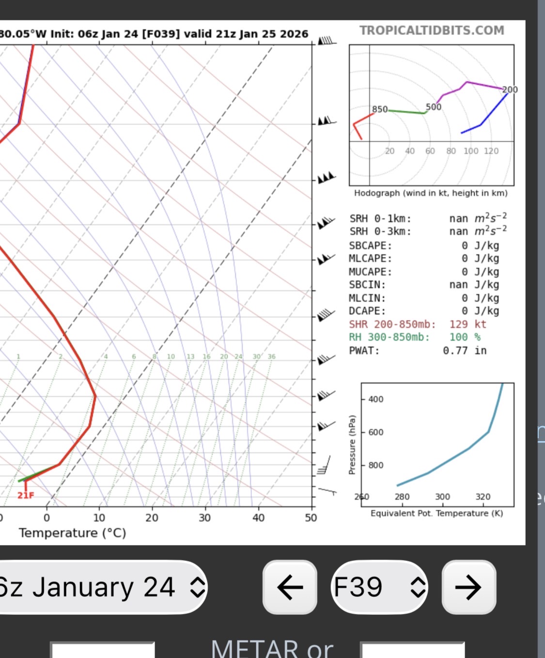
6z euro sounding looks pretty efficient, based on a quick read on pwats and snowfall.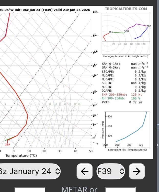
-
Pittsburgh/Western PA WINTER ‘25/‘26
CoraopolisWx replied to Burghblizz's topic in Upstate New York/Pennsylvania
-
Pittsburgh/Western PA WINTER ‘25/‘26
CoraopolisWx replied to Burghblizz's topic in Upstate New York/Pennsylvania
For me it’s a bit of PD2 and 2010. Both had strong WAA snowfall. -
Pittsburgh/Western PA WINTER ‘25/‘26
CoraopolisWx replied to Burghblizz's topic in Upstate New York/Pennsylvania
WSWarnings from Mexico to Montpelier. Impressive -
Pittsburgh/Western PA WINTER ‘25/‘26
CoraopolisWx replied to Burghblizz's topic in Upstate New York/Pennsylvania
For almost a week now, the GFS has been pretty consistent with a high qpf event for that time period. We’ll see if all of the guidance starts narrowing in on a solution by at least Wednesday. -
Pittsburgh/Western PA WINTER ‘25/‘26
CoraopolisWx replied to Burghblizz's topic in Upstate New York/Pennsylvania
Since 1900, out of the top 20 December monthly snow totals, only 2 of those seasons were below normal. So that’s a positive sign. -
Pittsburgh PA Fall 2025 Thread
CoraopolisWx replied to TheClimateChanger's topic in Upstate New York/Pennsylvania
12/9/92 might be my favorite storm, mostly for the nostalgia. -
Classic
-
Pittsburgh/Western PA Winter 2024-2025 Thread
CoraopolisWx replied to Rd9108's topic in Upstate New York/Pennsylvania
Decent little system this evening. Another band entering PA, should give northern Allegheny county some decent rates. -
Pittsburgh/Western PA Winter 2024-2025 Thread
CoraopolisWx replied to Rd9108's topic in Upstate New York/Pennsylvania
Have to see if the NS vort hanging back a bit becomes a trend, or just a momentary blip. -
Pittsburgh/Western PA Winter 2024-2025 Thread
CoraopolisWx replied to Rd9108's topic in Upstate New York/Pennsylvania
I think I had more days off that school year, than all the rest combined. Lol. -
Pittsburgh/Western PA Winter 2024-2025 Thread
CoraopolisWx replied to Rd9108's topic in Upstate New York/Pennsylvania
A true I-79 classic. -
Pittsburgh/Western PA Winter 2024-2025 Thread
CoraopolisWx replied to Rd9108's topic in Upstate New York/Pennsylvania
Wow, don’t see those speeds too often. -
Pittsburgh/Western PA Winter 2024-2025 Thread
CoraopolisWx replied to Rd9108's topic in Upstate New York/Pennsylvania
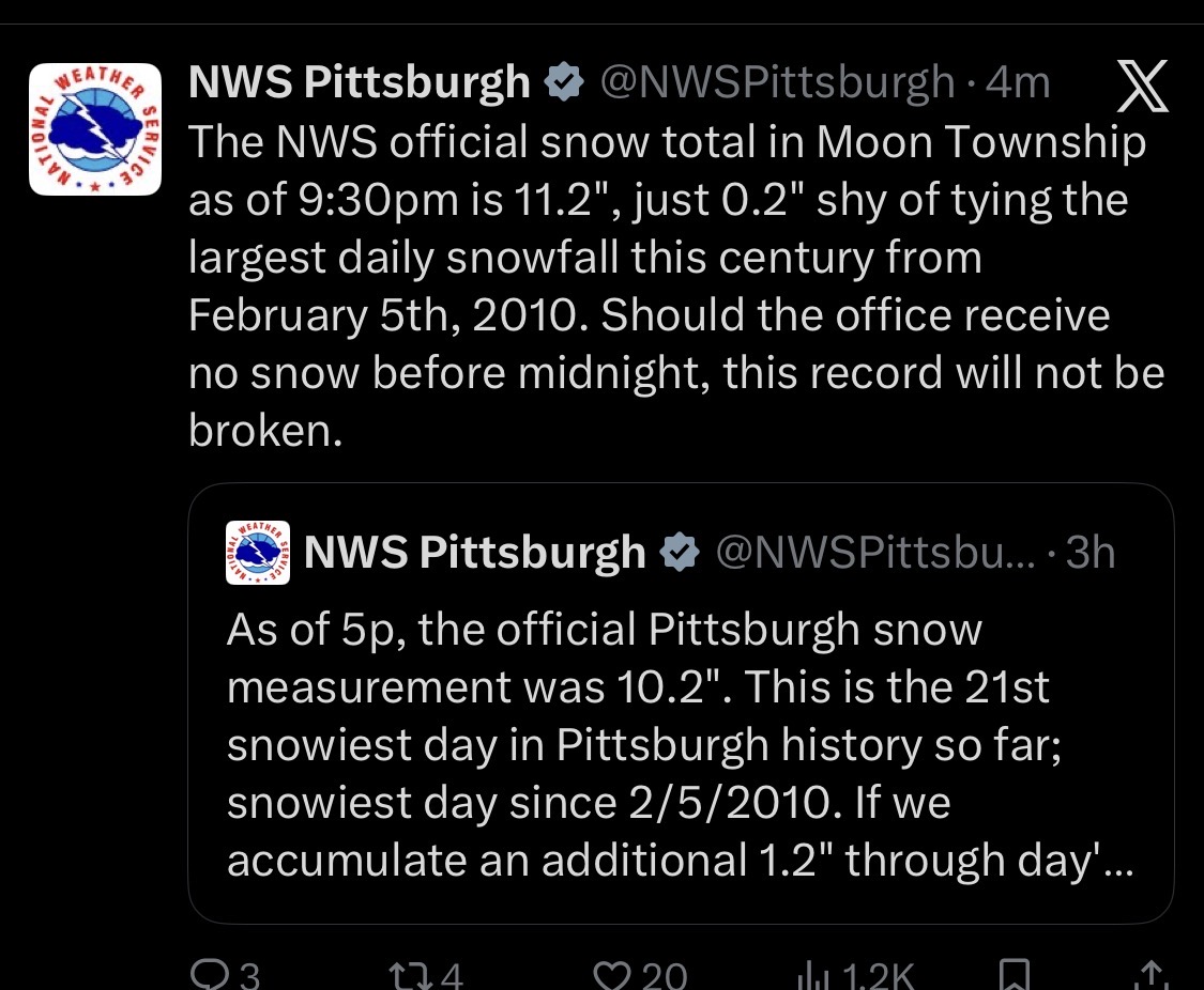
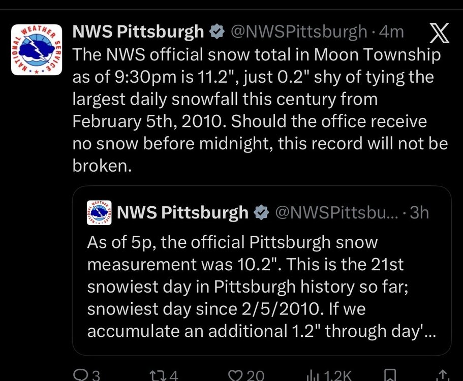
THE PITTSBURGH PA CLIMATE SUMMARY FOR JANUARY 14 2025...VALID TODAY AS OF 0400 PM LOCAL TIME.CLIMATE NORMAL PERIOD 1991 TO 2020CLIMATE RECORD PERIOD 1871 TO 2025WEATHER ITEM OBSERVED TIME RECORD YEAR NORMAL DEPARTURE LAST VALUE (LST) VALUE VALUE FROM YEAR NORMAL ...................................................................TEMPERATURE (F) TODAY MAXIMUM 18 359 PM 70 1932 36 -18 29 MINIMUM 10 829 AM -6 1964 21 -11 11 AVERAGE 14 29 -15 20 PRECIPITATION (IN) TODAY 0.02 1.15 1999 0.11 -0.09 0.05 MONTH TO DATE 0.66 1.39 -0.73 2.38 SINCE DEC 1 3.37 4.23 -0.86 5.18 SINCE JAN 1 0.66 1.39 -0.73 2.38 SNOWFALL (IN) TODAY 0.4 3.5 1917 0.4 0.0 1.0 MONTH TO DATE 9.3 5.6 3.7 4.2 SINCE DEC 1 15.0 13.3 1.7 5.3 SINCE JUL 1 15.8 16.1 -0.3 5.9 SNOW DEPTH 3 By tomorrow, we should break even for the first time in about 3 years. -
Pittsburgh/Western PA Winter 2024-2025 Thread
CoraopolisWx replied to Rd9108's topic in Upstate New York/Pennsylvania
Update focused on handling band of light to locally moderate snow showers across the central CWA, in a band that likely has its origins from WNW flow off of southern Lake Michigan. 12Z PBZ sounding shows saturation through most of the dendritic growth zone beneath an inversion at around 760mb. Many of the CAMs did not handle this well, with the NAM3km nest being the one model that has something close to reality. -
Pittsburgh/Western PA Winter 2024-2025 Thread
CoraopolisWx replied to Rd9108's topic in Upstate New York/Pennsylvania
Glad to hear that. There’s some valley floor locations in the lower mon valley, that have probably been in the single digits the past two winters. It’s been a rough stretch for snow totals down that way for awhile. -
Pittsburgh/Western PA Winter 2024-2025 Thread
CoraopolisWx replied to Rd9108's topic in Upstate New York/Pennsylvania
Hopefully one of the few times WAA can benefit us. Having the nose of the confluence east of the apps could produce a slight inverted trough. This feature has benefited us in the past. -
Pittsburgh/Western PA Winter 2024-2025 Thread
CoraopolisWx replied to Rd9108's topic in Upstate New York/Pennsylvania
Wow, McKnight Rd around Peebles and Babcock is like another world.