SnowGoose69
-
Posts
16,823 -
Joined
-
Last visited
Content Type
Profiles
Blogs
Forums
American Weather
Media Demo
Store
Gallery
Everything posted by SnowGoose69
-
The ICON was remarkably good with the track of Helene, it was overall a bit too far SE at this range but in the final 72 was close
-
As far as wind damage the ideal location for this to come in probably is around Venice or N of Crystal River. Once inland of those 2 locations you have to go for miles for any significant pop centers. As far as surge, you'd be bringing bad surge into Tampa on the N track and into Charlotte Harbor on the S track
-
The north side of Helene didn’t have too extensive an area of big winds. It was mostly on the SE side. This storm it shouldn’t be as bad since it’s not going to be moving as fast. Places like Palm Beach and Fort Lauderdale might be the biggest beneficiaries if this comes in over Sarasota or just south. With Helene they’d have seen 80 mph gusts. They should be 45-55 based on 925 winds on the globals with this which shouldn’t be a problem outside shutting down all 3 airports as that’s a 70-80 degree crosswind from 200-210
-
I think it’s still likely landfall ends up down near Sarasota or a tad south of that. We should see models move that way next 24 hours. Part of that reasoning is they are showing a harder SE movement next day or so
-
-
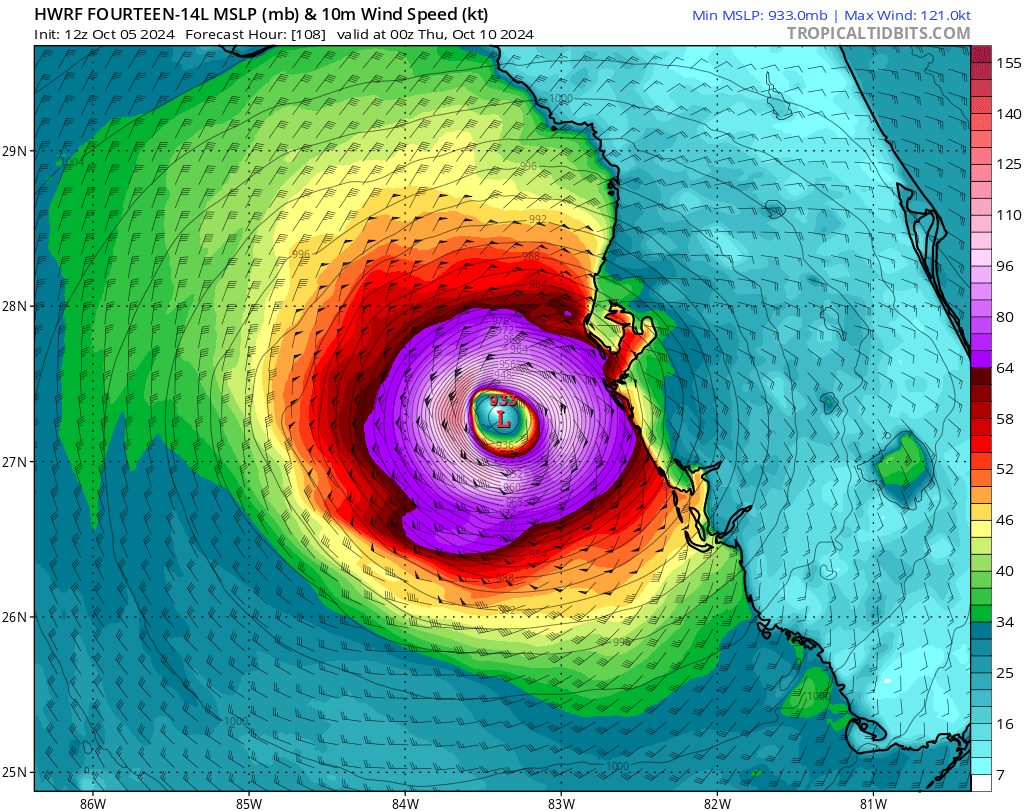
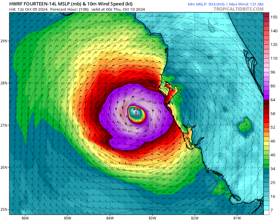
HWRF directly into Tampa at 933mb
-
I guess the good news with those HMON/HAFS tracks is the population is way lower where they bring the storm in
-
06z Euro is much slower than the 00Z but it may have ended up close to the same location of landfall in the end
-
GA I think had more in Irma and Zeta, about 1.2 and 1.1 but that was sort of skewed by the fact ATL metro was impacted, this time they likely account for under 200K of those outages
-
It should be done in an hour or 90 minutes as the system lifts out the dynamics weaken and this is also a bit of a downslope direction
-
Unfortunately this area will make its way into Augusta. I think it might weaken somewhat by then but might still see 70-80mph
-
87kts now. I was not sure those were correct until I saw this post as they seemed too high
-
Lots of gusts of 84-99 on the FL mesonet. Valdosta may actually see worst winds pass E of them out of the SSE in the ERN eye wall
-
FPY is an AWOS so odds are something higher than 86kts did happen but no PKWND algorithm is on those systems
-
FPY 86kts
-
https://mesowest.utah.edu/cgi-bin/droman/mesomap.cgi?state=FL&rawsflag=3
-
There are many mesonet stations in the Suwanee Springs area...we may get higher wind confirmation there when eye wall goes though
-
FPY gusting to 71kts right now, surprised they never got anything bigger but the AWOS does not report a peak wind so hard to know what the real high was
-
Perry ASOS 55kts now, it only reports every 20 mins so this may be last ob we get, if not the 1035 one might be 80kts plus
-
Its attempting to stay out over the bay more because the NNE movement would take it over land faster, typical frictional impacts, notice the radar images have really intensified as a result too, it'll eventually resume NNE movement probably and just come onshore but its doing the typical land aversion attempt
-
I believe its trying to move more towards the open water vs keep heading NNE into the land closer to it, you can see some tightening too as a result, echoes have really ramped up last 20 mins
-
If it does not turn N soon they could be on the N or NNW side so even they may be west of center.
-
Select all networks, even decent gusts from the NNW by Apalachicola https://mesowest.utah.edu/cgi-bin/droman/mesomap.cgi?state=FL&rawsflag=3
-
Yeah looks like Augusta is in trouble for sure.
-
FPY winds being only 20kts is funny. I’m always amazed how with land falling canes winds don’t get going til the eyewall comes in