Allsnow
-
Posts
26,462 -
Joined
-
Last visited
Content Type
Profiles
Blogs
Forums
American Weather
Media Demo
Store
Gallery
Everything posted by Allsnow
-
 Hopefully it nails the 20th as well
 -
Extended summer stormlover74 future snow hole banter thread 23
Allsnow replied to BxEngine's topic in New York City Metro
They have done a ton to reduce CTE by protecting the players and adjusting the rules. It won’t be completely eliminated because it’s a contact sport -
Extended summer stormlover74 future snow hole banter thread 23
Allsnow replied to BxEngine's topic in New York City Metro
-
Wow 72 degrees below normal
-
Extended summer stormlover74 future snow hole banter thread 23
Allsnow replied to BxEngine's topic in New York City Metro
NFL can’t do anything wrong currently -
Extended summer stormlover74 future snow hole banter thread 23
Allsnow replied to BxEngine's topic in New York City Metro
If the nfl could make a buck selling oxygen they would… it’s ridiculous to ask your loyal fans to pay to watch a game -
Extended summer stormlover74 future snow hole banter thread 23
Allsnow replied to BxEngine's topic in New York City Metro
Are other platforms streaming it for free? -
Extended summer stormlover74 future snow hole banter thread 23
Allsnow replied to BxEngine's topic in New York City Metro
Samesies -
Extended summer stormlover74 future snow hole banter thread 23
Allsnow replied to BxEngine's topic in New York City Metro
I refuse to pay a streaming service to watch that game -
Extended summer stormlover74 future snow hole banter thread 23
Allsnow replied to BxEngine's topic in New York City Metro
I hope they don’t move the game -
Defiantly. I always felt like we would get a good pna response in p3. We just need a favorable window with how active the stj has been this winter
-
Now euro op says nyc gets close to their seasonal avg next week
-
This
-
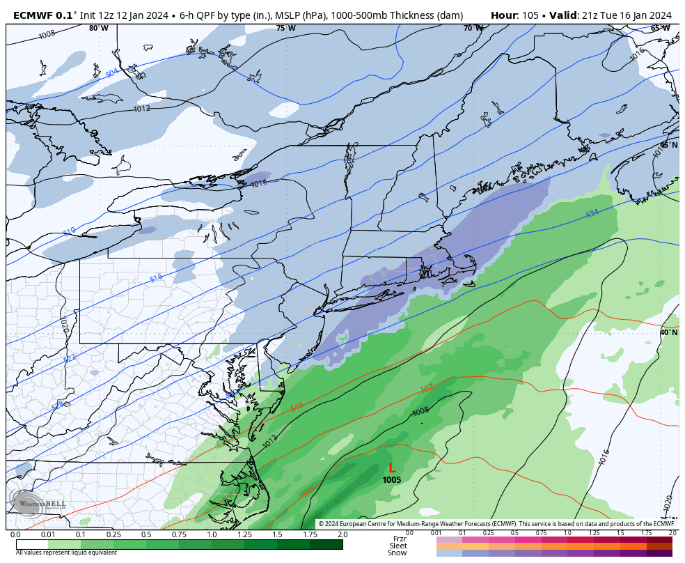
Light snow for the area Tuesday morning. Looks like the gfs
-
Completely misssed my point, but okay
-
Jan Medium/Long Range Disco 2: Total Obliteration is Coming
Allsnow replied to Jebman's topic in Mid Atlantic
I think at this range, considering all the runs we have looked at for next week, it’s a good bet we see accumulating snow from DCA to NYC. -
Jan Medium/Long Range Disco 2: Total Obliteration is Coming
Allsnow replied to Jebman's topic in Mid Atlantic
CMC looks similar -
Jan Medium/Long Range Disco 2: Total Obliteration is Coming
Allsnow replied to Jebman's topic in Mid Atlantic
Yeah, 20th coming back alive this run with the more progressive look for the 17th