wdrag
-
Posts
5,603 -
Joined
-
Last visited
Content Type
Profiles
Blogs
Forums
American Weather
Media Demo
Store
Gallery
Everything posted by wdrag
-
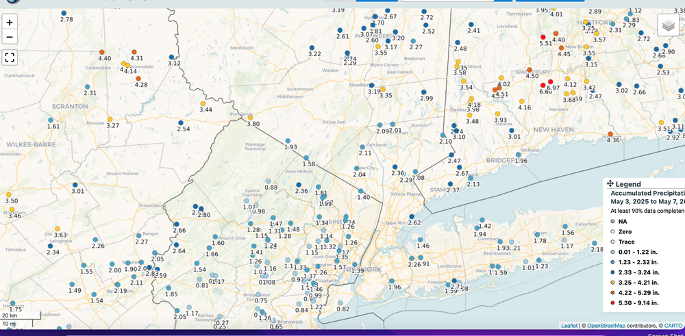
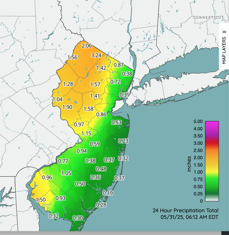
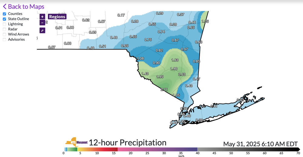
My remote AWN in Wantage NJ has 1.85 since midnight,, probably a bit less but close. Added NJ and NYS mesonet climate network maps past 12 hours. Representative. Click for clarity if interested.
-
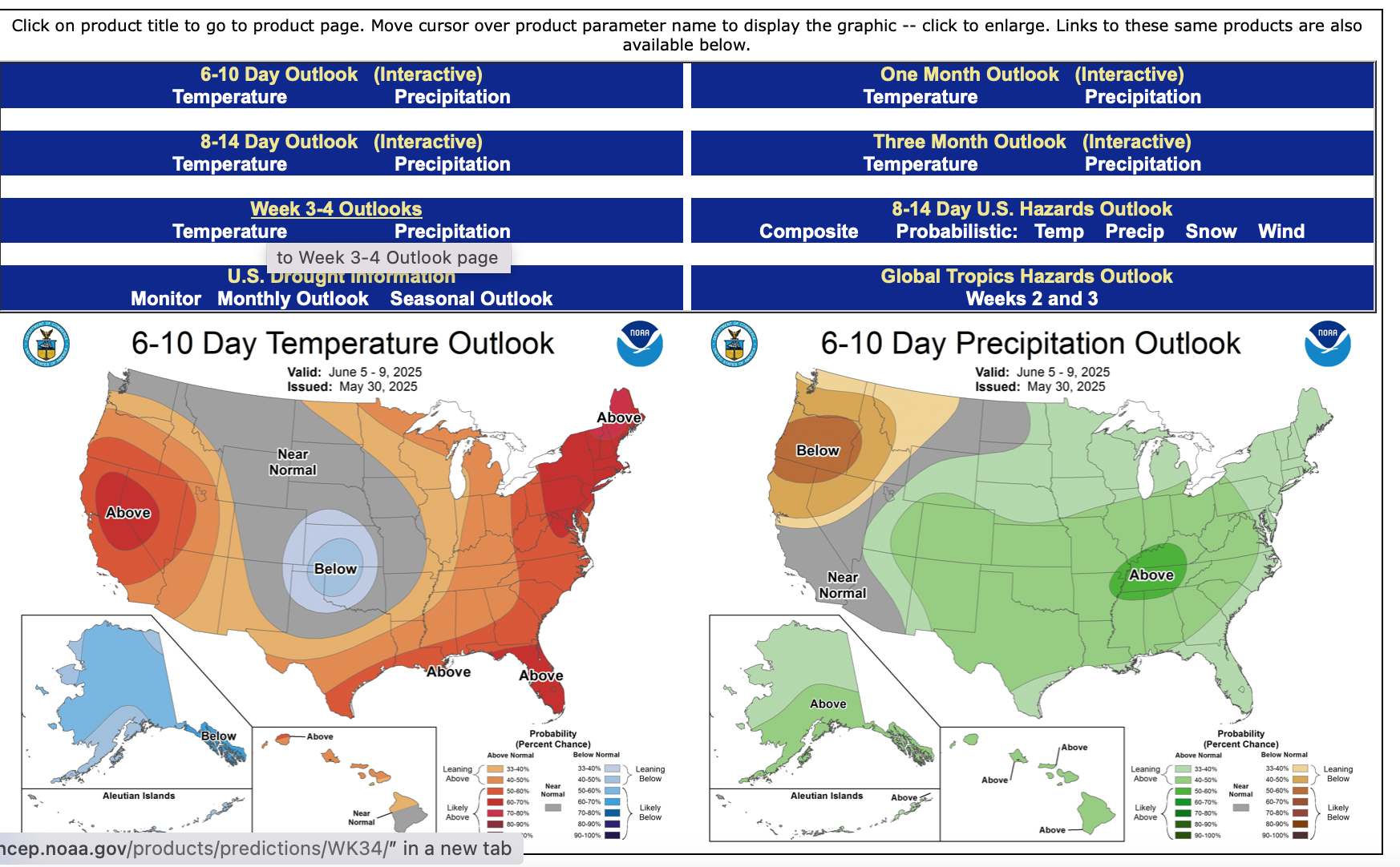
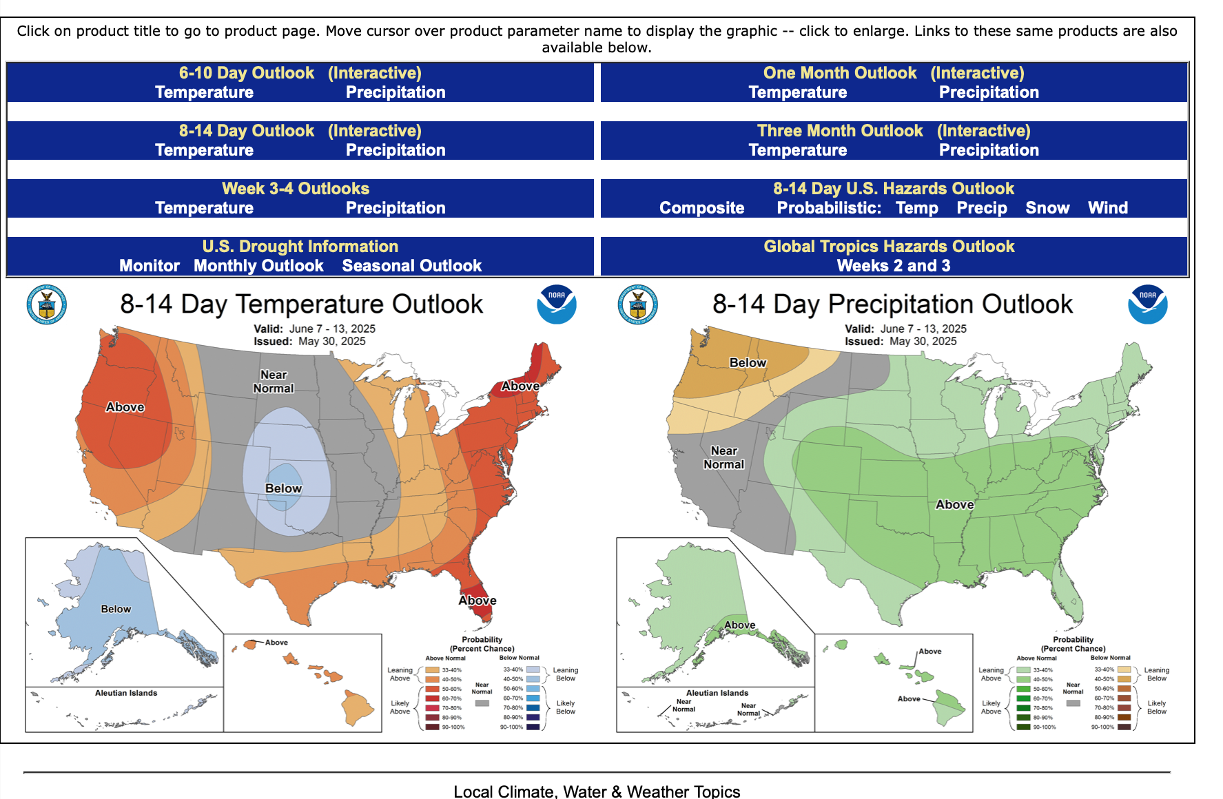
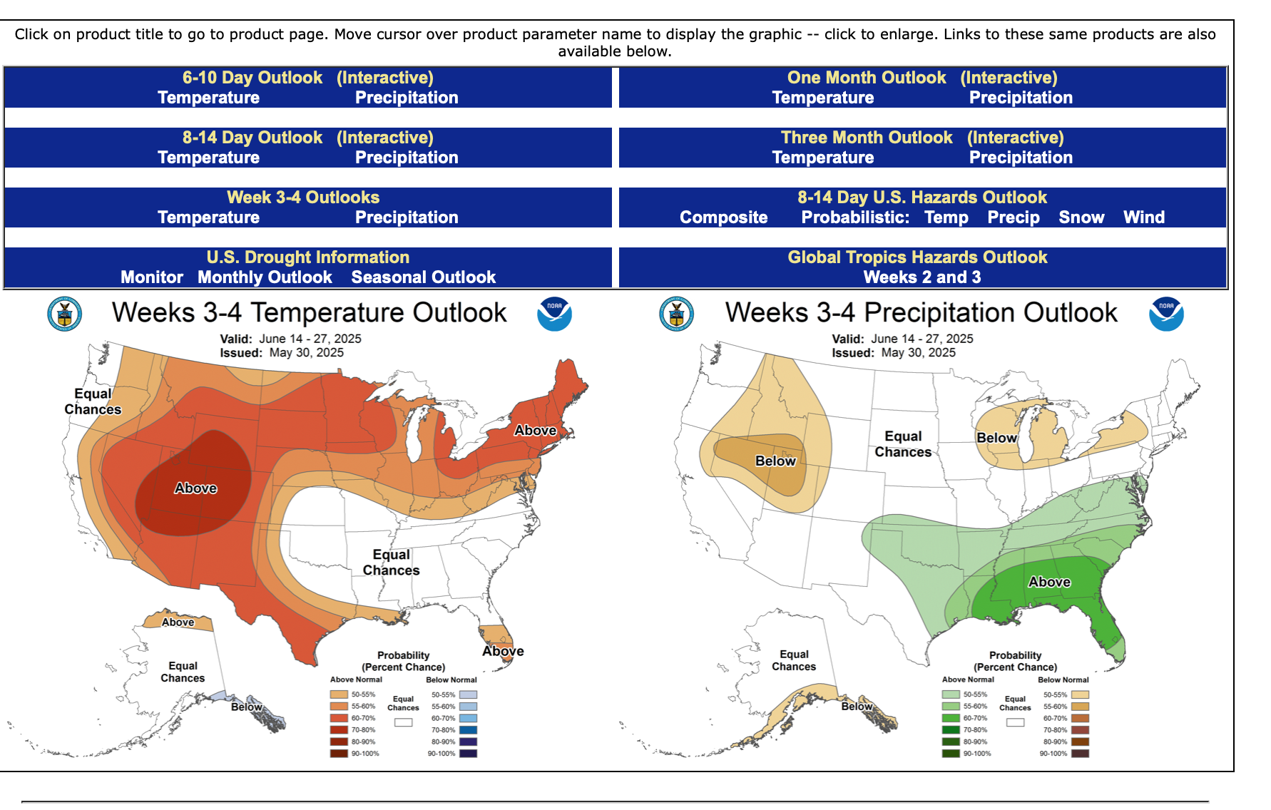
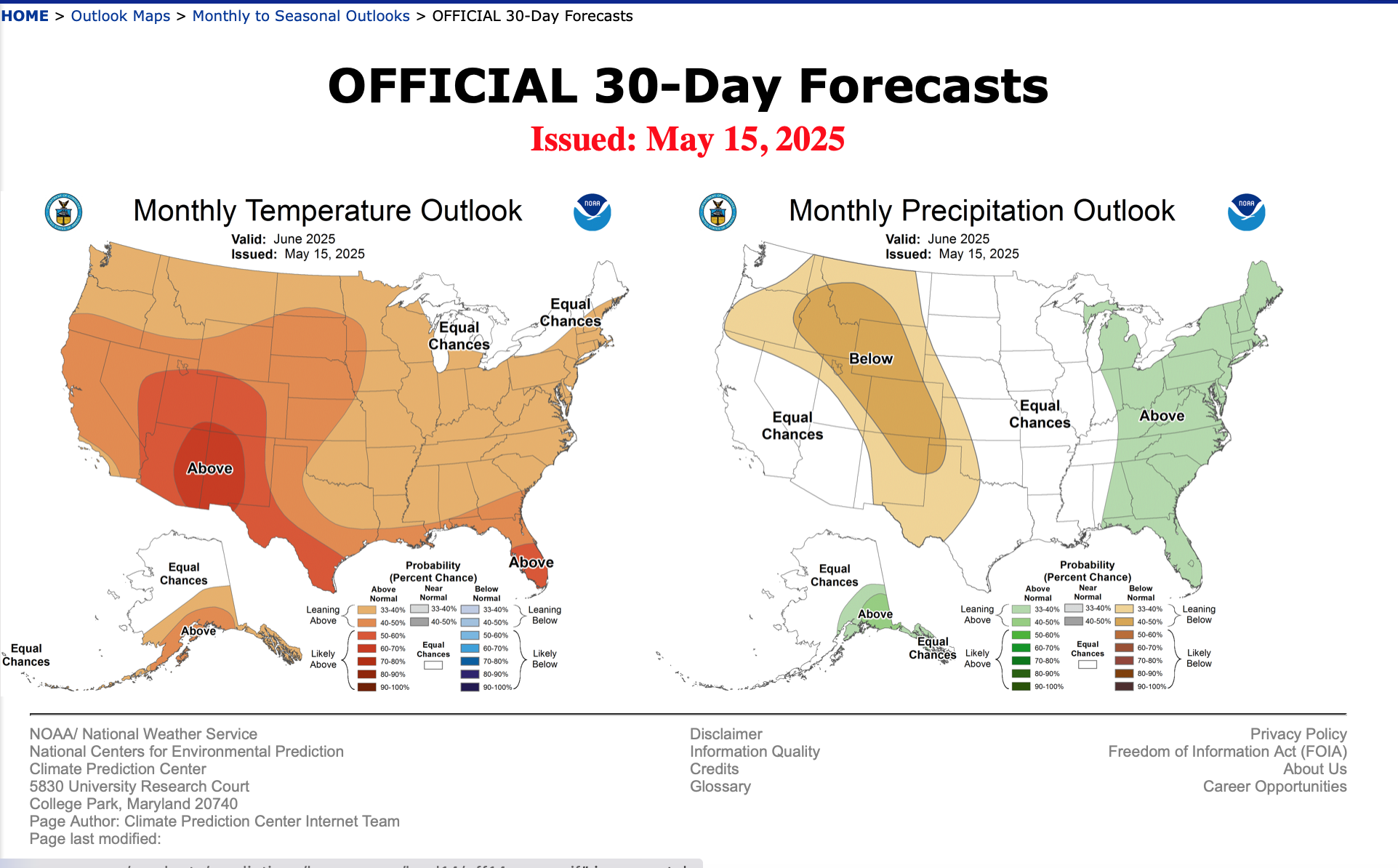
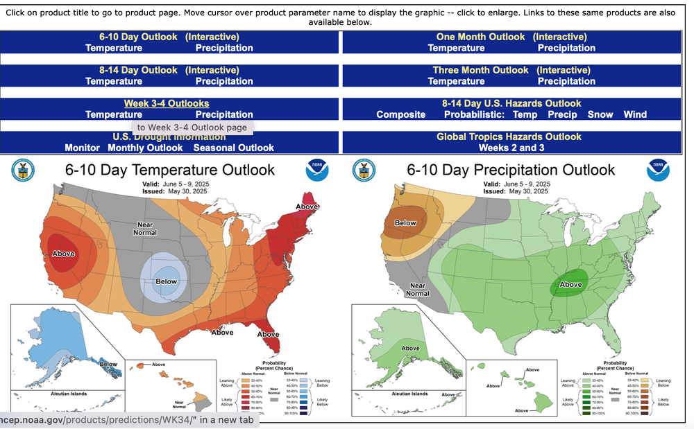
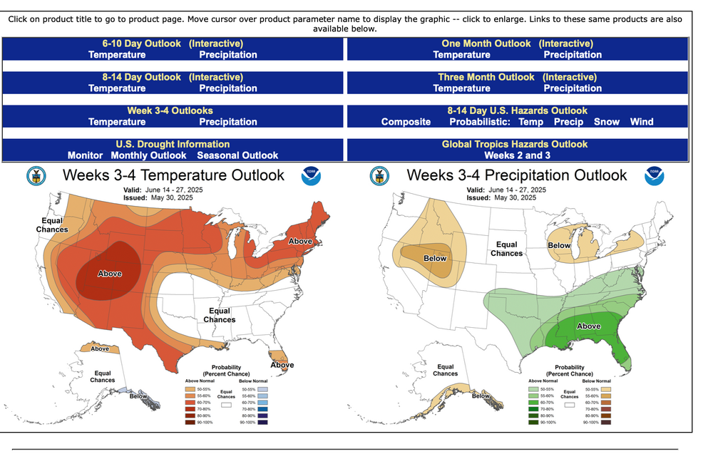
And the D 6-10, 8-14, Week 3-4 as issued yesterday May 30 for June, and the June outlook issued May 15 which I think gets updated in the next day or two.


-
Presuming I get time, I'll add CPC June Outlook and the D8-14, week 3-4 guidance around 7-8P.
-
Continuing with expectations as described above posts. GEFS continues more aggressive with the warming than the EPS.
-
So the interior daily 80s delays a couple days into the first week of June but by June 3-4 they should be going and some of the modeling implies spotty 90 interior possible Friday-6th-at least Sunday 8th. AC will be working a bit for the interior by next weekend. 00z/28 GEFS is more aggressive with the warming so we'll monitor.
-
Might be a little early with this monthly... but I like the pattern for summer warmth (daily 80s at least inland the first week of June). 5H Weakness in our area suggests cool frontal passages and a chance for frontal showers/tstorms so drought hopefully doesn't return in June. GEFS from 00z/23 through June 25 suggests ridge centered NMex/TEX with zonal flow N USA and maybe periodic chance at 90F with a strong TStorm near CFP? Long ranging is difficult for ensembles. Others may want to add EC suite etc outlooks for June. Monthly trend is warmer than the 30 year average so I dont see a reason deviate. Don? Other's?
-
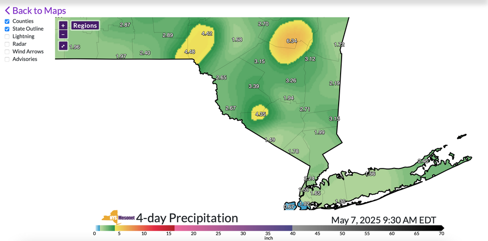
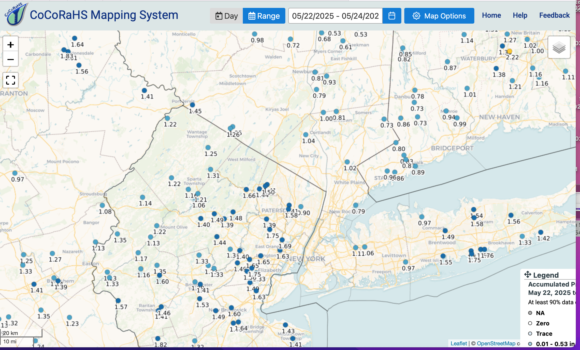
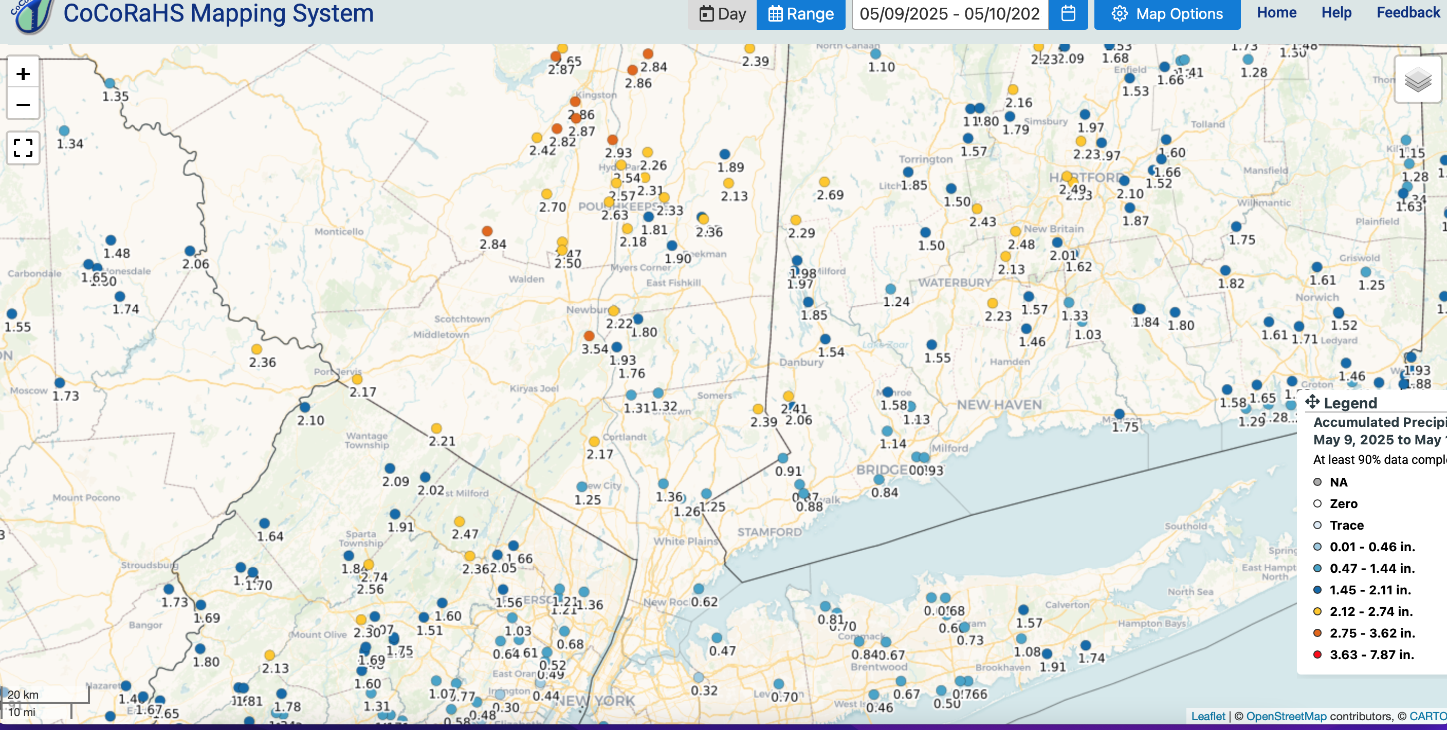
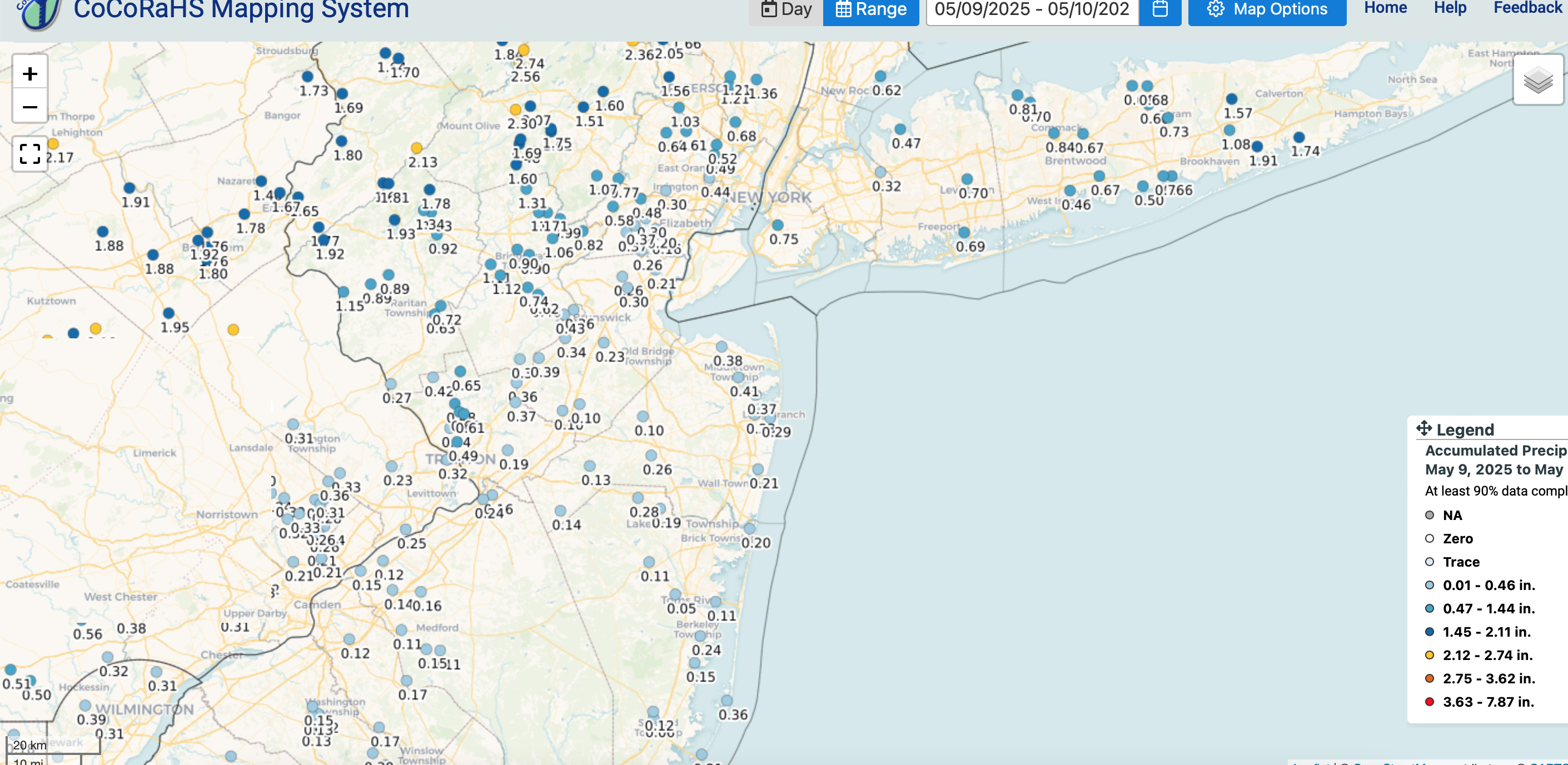
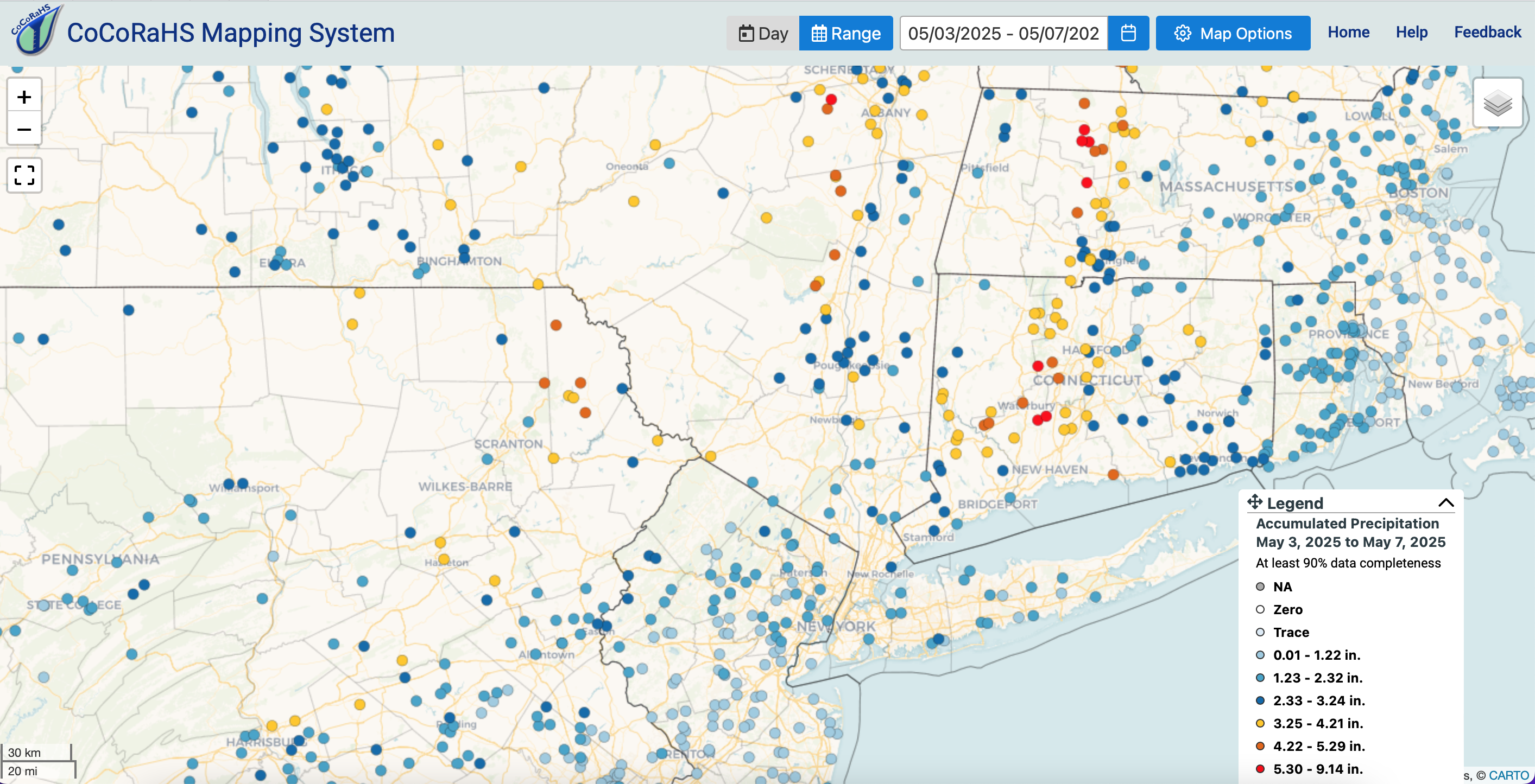
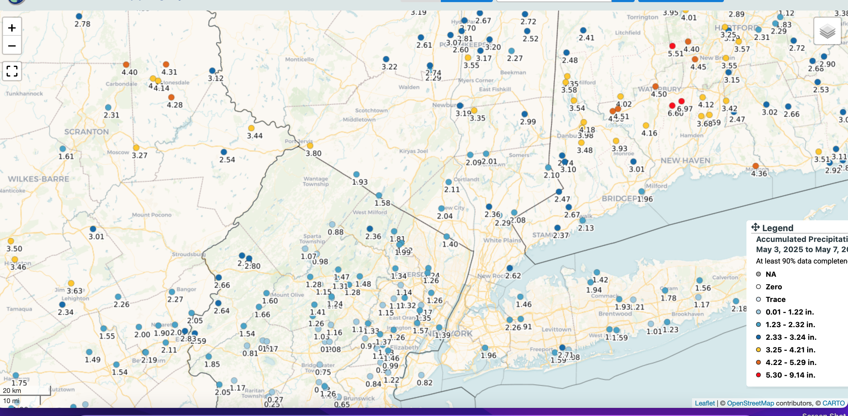
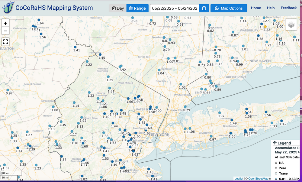
3 day totals via CoCoRaHs reports which looks good including NYS Mesonet and my Wanted 1.25. Drought over for the time being, as per last Tuesday's report and this attached data that goes into the 5/27 report publicly available 5/29. EC suite was overdone for this period, no doubt...both wind and rain. Looks to me like milder this coming weeks 70s morphs into summer June 1, more or less on schedule with at least 80s almost daily the first week of June, excepting coastal sea breezes. CoCoRaHs 3 days attached-click for clarity.
-
No change in considerations for Wed afternoon-Thu night 2" g 50 part of LI and s CT. No thread as of today, per prior consideration of low stream flows and higher FFG, excepting parts of central and nw NJ. Am pretty of a gale as we're now 48-60 hours in advance for the LI shores. Regarding verification... it's how thorough we look and what we dismiss as poor siting etc. When you're out there gusting 35 knots... it becomes a significant threat to to general non-mariner. We'll see how OKX responds tomorrow regarding possible hazards.
-
Wed-Thu: Looks somewhat interesting as GEFS seems to have cluster of closed 5H low near e LI. 50MPH wind gusts and 2" rain possible LI area, esp Thursday. We'll see. No thread since some ensembles are weaker and recent dryness has low flows there and high FFG, except nw NJ which may be vulnerable??? Check again tomorrow.
-
Keping an eye on next Wed-Thu for a thread but only if LI s CT widespread 50+ and Rfall 2". Unlikely thread at this time but has been looking interesting for several days. Follow local resources and WPC.
-
already heavy showers N of I80 this morning in far NNJ with the 1/3rd inch via NJ Climate on target.
-
After they feast on the leaves fort a while, they tend to die off, if not sprayed-controlled-killed. The oaks will have a second leafing in late June and attempt to recover. This is our second year in a row. So far minor but noticeable. Can't hear them eating the leaves yet when you walk the street kr see the brown caterpillar poop on th street. Hope it doesn't get too bad. State is spraying certain sections of Wantage NJ
-
Wantage: this part... about 1/4" past hour ...am loving the catch up here. NJ Climate obs look good. Gypsy moths starting here in this part of Sussex County extreme nw NJ again. Second year running. Not prolific yet but for me, time to DUCK TAPE band the oaks. Have a good rest of the day.
-
Timing... not everything clean cut. Follow SPC D2 coming out in an hour or so.
-
A final note from me today: Saturday's coming convection may have some hailers as I've seen some guidance suggest iso severe further N than currently outlooked, up into e NYS. Going to be some problems for air travel into NYC next several days (beyond the Newark multi problems).
-
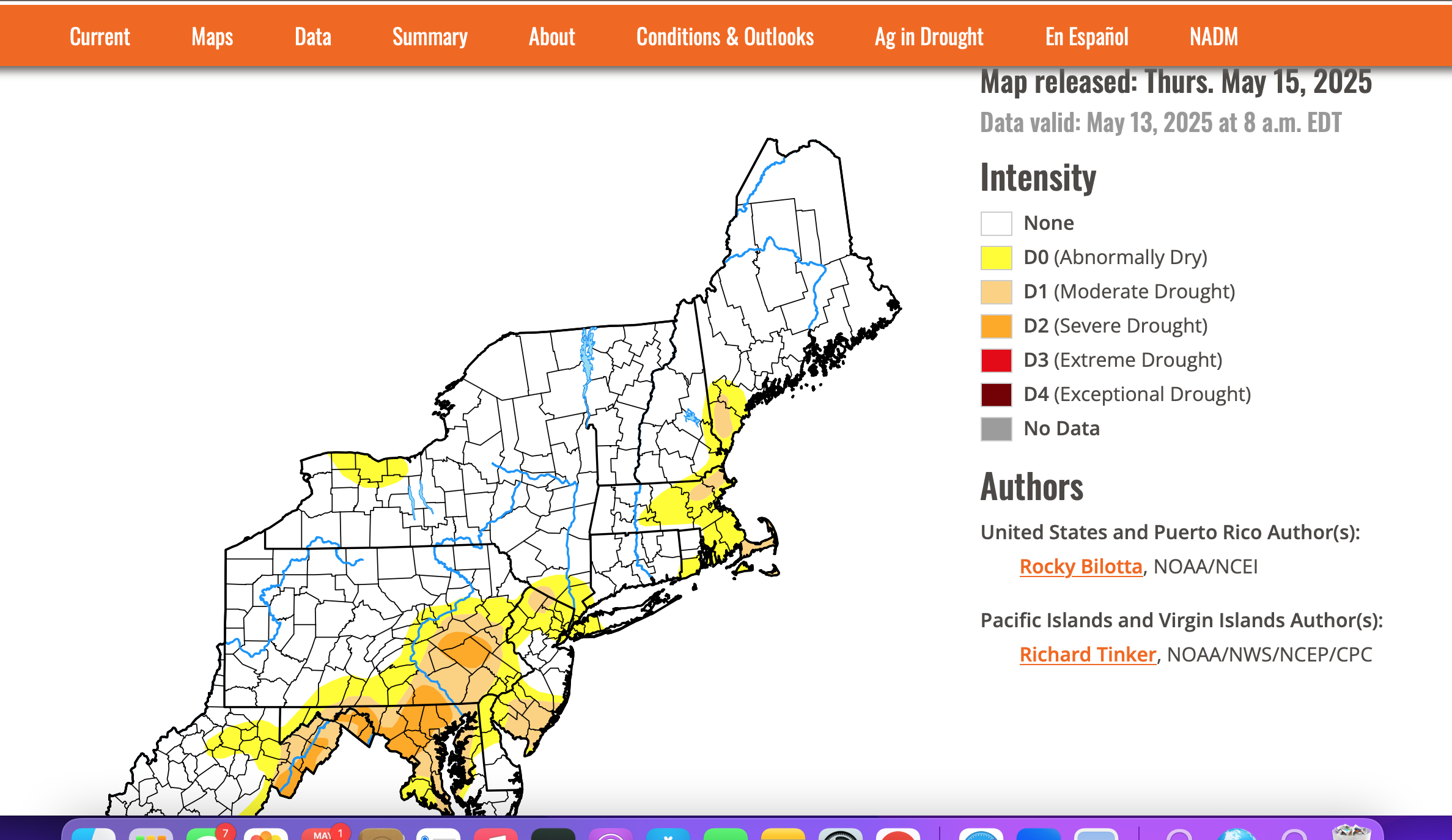
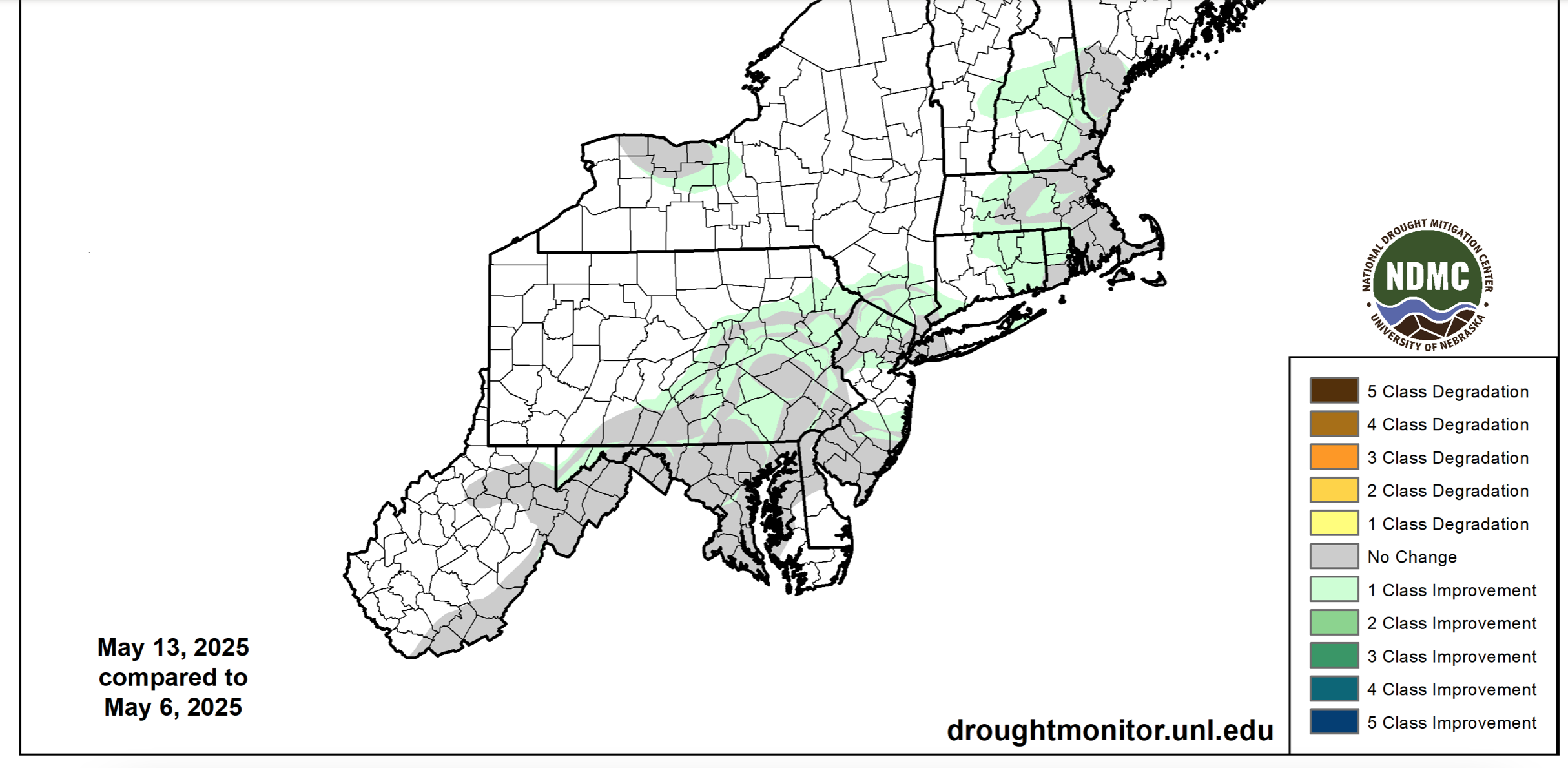
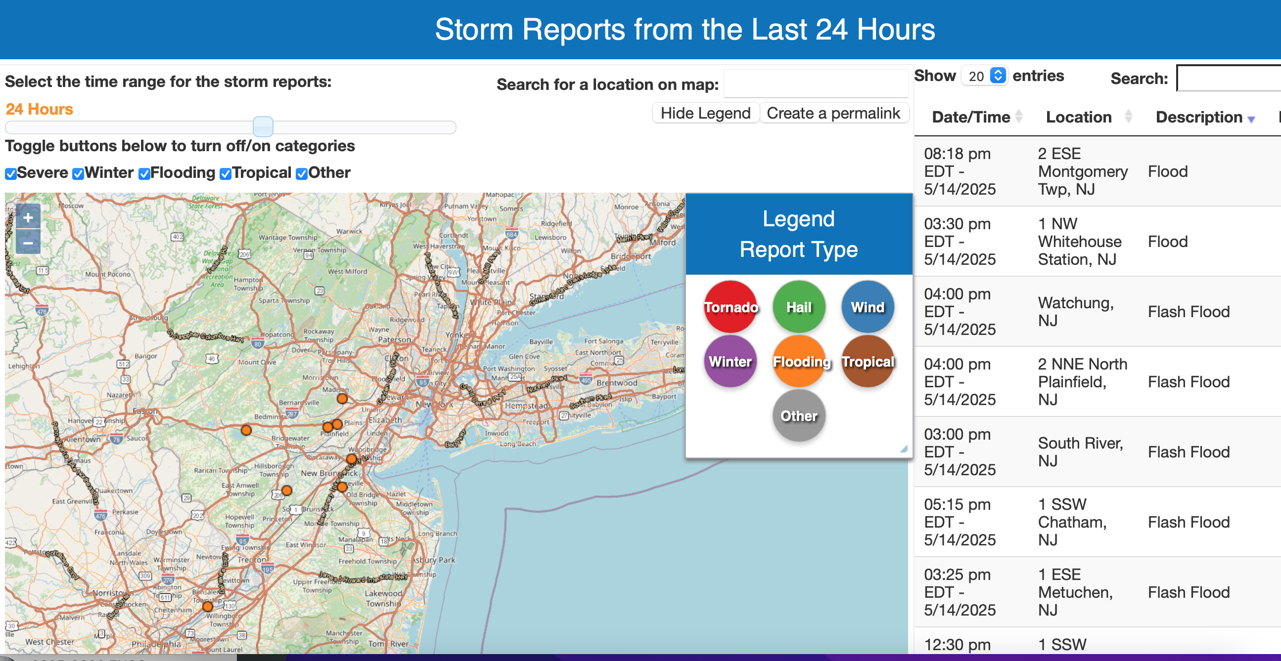
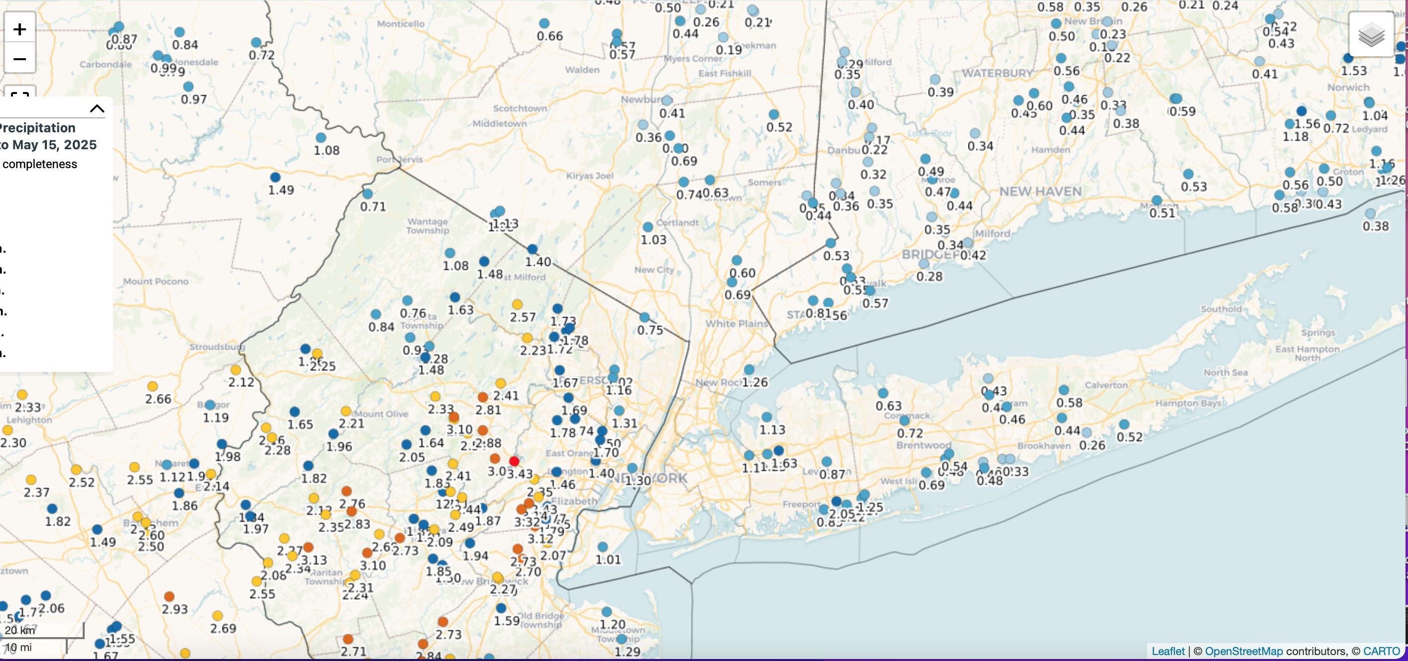
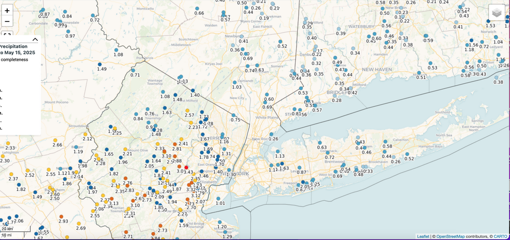
Good Thursday morning everyone, May 15. All graphics can be clicked for clarity. Added the drought monitor (ONLY LONG TERM NOW IN OUR AREA) and one week classification change (please refer to the legend), plus the flooding reports in central NJ yesterday and the unexpectedly large 48 hour rainfall ending this morning via CoCoRaHs. This 48 hour rainfall will be newly added to next weeks drought monitor assessment and is in my opinion good news for our coming summer (JJA). Sussex County reports (nw NJ) dropped off rapidly to the west fringe of NJ (my part of southern Wantage NJ two day 0.92)


-
No thread yet... if ever, but MLB games in Cleveland, Atlanta, Philly, NY I expect will see delays or cancels into D-N double headers this coming Monday-Thursday, possibly Fri and the weekend. Most of the delays-cancels should be Tue-Wed, as a start for my own expectations. I apologize if this duplicates someone else's post. Trends for the axis max rainfall may shift north as it has been the past couple of days.
-
OBS for OKX Flood Watch (attached) into early Saturday 5/10/25
wdrag replied to wdrag's topic in New York City Metro
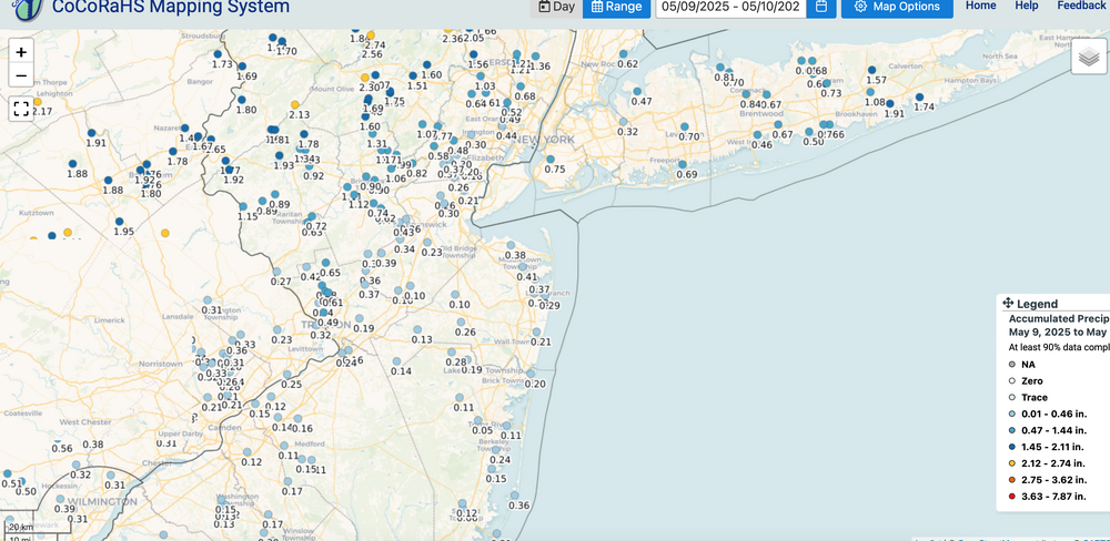
CoCoRaHs two day accumulations attached-click for clarity. Max observed 3.5" (se NYS) unless local offices post greater. Max near 2" e LI. Two minor flood warnings in CT with slow rises into Mothers Day. Not much of a watch verification but the rain was needed as displayed and should alleviate what is now listed as only Long Term drought n NJ/e PA/Southern New England. As some noted; s NJ could use more. Have my hopes for more than indicated 12z Tue/13-00z Fr/16 of next week if the upper low can lift a little further north. Worthy of monitoring but no thread til next week, if the unlikely spot 3" occurs up here along and north of I80. Right now we're sort of the northern fringe as per 06z/10 WPC ensembles.
-
OBS for OKX Flood Watch (attached) into early Saturday 5/10/25
wdrag replied to wdrag's topic in New York City Metro
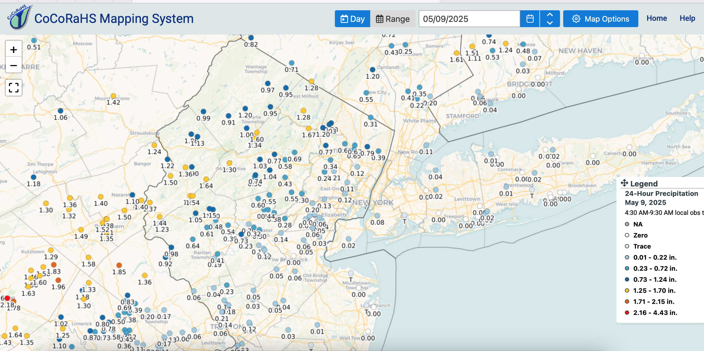
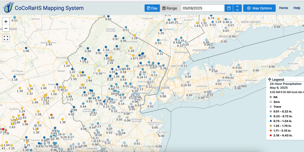
CoCoRaHs climate observers 24 hr qpf ending 845A/9 Click for clarity.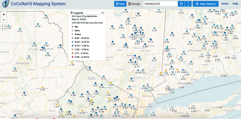
-
OBS for OKX Flood Watch (attached) into early Saturday 5/10/25
wdrag replied to wdrag's topic in New York City Metro
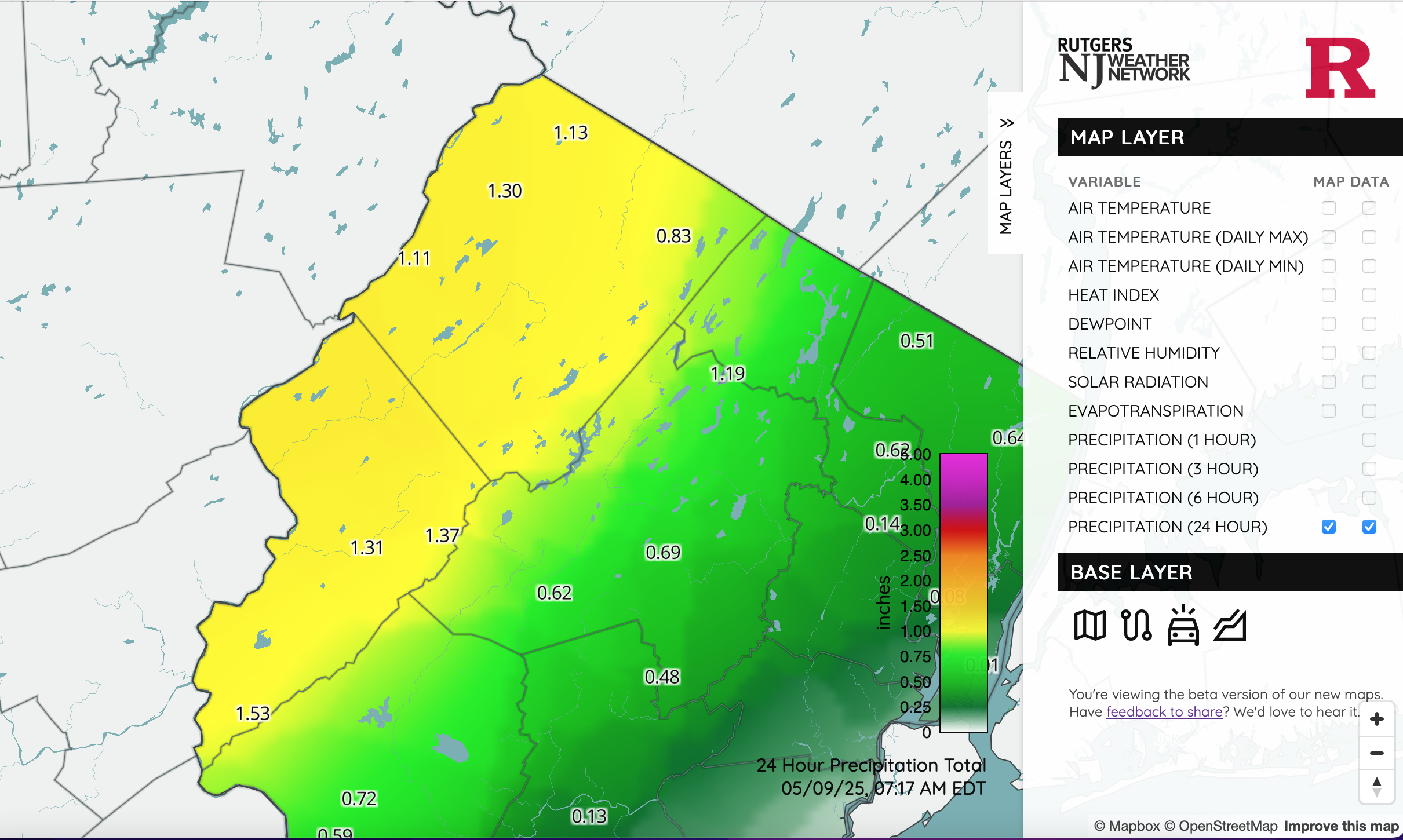
I still dont quite understand the Watch in our area and its expansion but going with it. NYS mesonet all under 1" so far. NJ however, this is legit. Click for clarity. Wantage fits with at least 1.34 so far... needed.
-
Added an OBS thread for the OKX Flood Watch. Am not enthused as I'd like to be, mainly due to antecedent conditions but potential does exist for spot 4" amounts se NYS, W CT... basically within the axis of most modeling heaviest rain northwest of I-95. Seems like the FFG is on the higher side but training - repeat episodes could result in spot flooding within the OKX Flood Watch. CT RVR Flood warning is minor at this time and may not crest til the weekend. Have a good night.
-
OBS for OKX Flood Watch (attached) into early Saturday 5/10/25
wdrag replied to wdrag's topic in New York City Metro
Wantage NJ 0.62 125P-7P. -
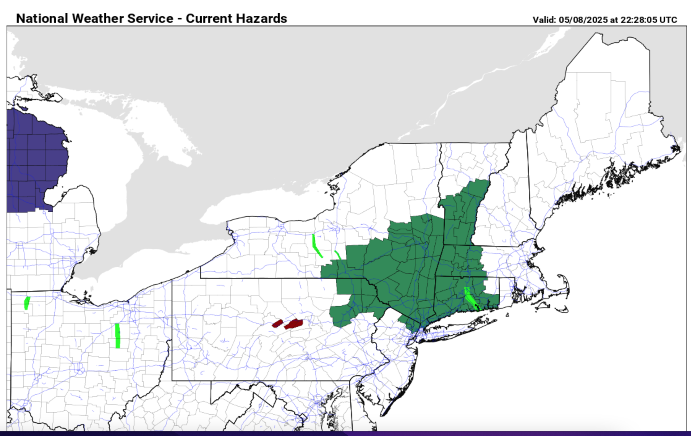
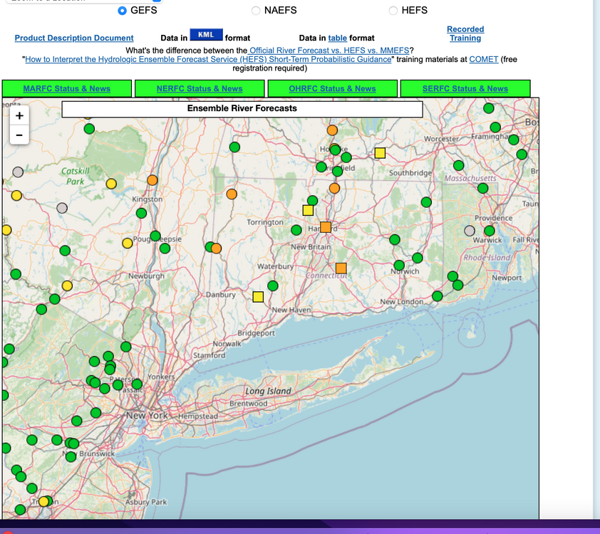
Isolated 4" rainfall possible by daybreak Saturday for w CT, se NYS where OKX has issued a flood watch this Friday afternoon 5/8/25. Most modeling has a needed 1-3" spread out over a 36-42 hour period ending Saturday morning. Flood guidance suggests we'll need 2.5" in a 6 hour period for flooding. Lesser rainfall LI NJ and ne PA under 1.5". A snapshot of ensemble forecasts showing minor flooding anticipated at several gages in the north part of the NYC subforum. Long ways to go. We'll add some CoCoRaHs amounts at 9A Friday and see where we stand.

-
Wantage NJ 8 s High Point. 0.41" 125P-2P in my stratus (0.45 on my AWN). So the .41 matches the OHP,THP,STP seen at 220PM this afternoon off DIX. No thread at this time... if NWS drops a watch on I84 I lmght add a thread...that seems where iso 4" reports should occur between today-12z Sat. Unlikely thread at this time.
-
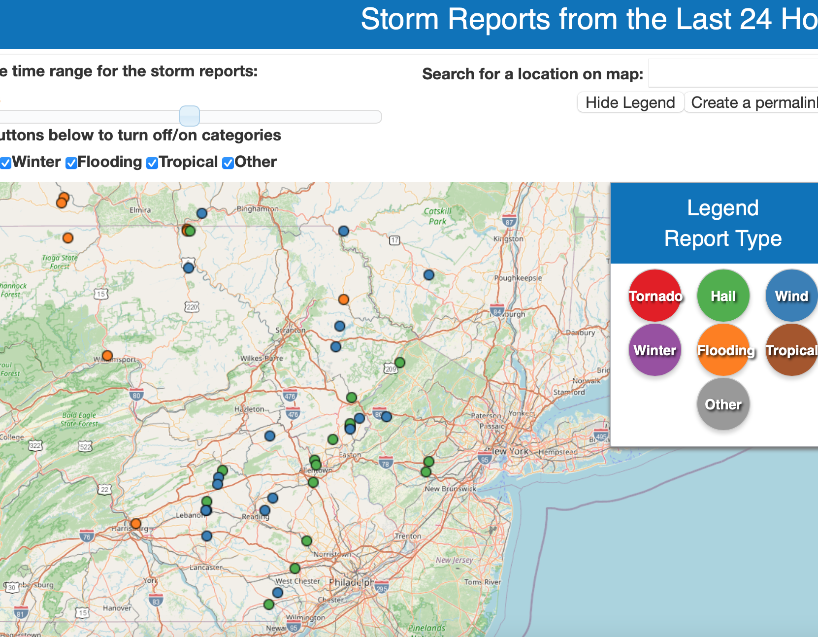
No thread for 1-3" interior late Thu-early Fri. Antecedent not quite high enough. Samples attached of actual rainfall via CoCoRaHs and NYS Mesonet. (Fri-Tue). (click for clarity) Also yesterdays hail reports near our area in green...not necessarily severe hail.