wdrag
-
Posts
5,603 -
Joined
-
Last visited
Content Type
Profiles
Blogs
Forums
American Weather
Media Demo
Store
Gallery
Everything posted by wdrag
-
Good Saturday morning all. Beneficial rain is coming 10/29-31, along w a short period of wind gusts on the coast near 50 with associated spotty power outages, and then behind the the system widespread gusts 40 MPH around 10/31 or 11/1. Rainfall still uncertain but certainly more than 1/2" and a couple climate sites may exceed normal monthly totals with potential for near 3". Target for the heaviest rain uncertain but modeling is coming into more agreement. One thing to note... yesterdays 18z GFS had nil but its ensembles about 1" in NYC. Also, fwiw, the ensembles have so much spread that they are comparatively timid in comparison to the OPS rain and wind production. Despite tides astronomically modest, I think there could be a period of minor tidal flooding. Right now not quite as fierce as the prior (10/12-13) thread, so no new event thread, as yet.
-
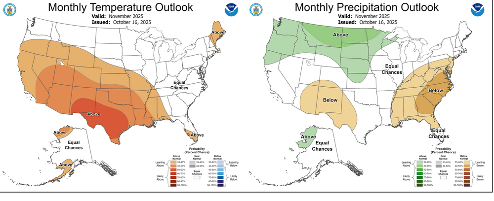
Added CPC's Oct 16 outlook.

-
Not threading unless today's varied 00z/24 ensemble guidance coalesces into stronger wind, and certainly heavier than the early morning 0902z/24 WPC 7 day outlook. Still time for stronger but a day of ensemble cycle trends have weakened the potential for a closed low across PA/NJ--the GEFS now the outlier strongest. Beneficial rain coming with gusts 40 MPH 10/28-10/31. Results: attempts to raise monthly rainfall closer to October normal, isolated power outages possible and minor coastal flooding likely due to days of onshore flow, building waves and surge of at least a foot at high tide. Should the future ensemble evolution grow into something more than minor impact, will thread but for now...not. Will recheck late today.
-
18z EPS AI flat, sort of like 12z EPS. That wont produce a thread. just have to wait this out.
-
Good afternoon everyone, Self - caution. Use your own interp. Some time before any thread on a possible (in my mind probable) 1-3" rain event with a brief period of power outage fully leafed tree power outages on the coast and even isolated slight R# eddy transfer 40-45 MPH gusts inland beneath the potential 850 MB se 60 kt jet on the 30th. That rainfall if it occurs (it can still end up less than 1" for us with the bigger heavy rain in New England), will bring most if not all OKX climate sites close to normal monthly totals. So... another cycle or two of ensembles before committing. ECAI hopefully is on the right track as its been steadiest. Of interest is the 06z ECAI distant Melissa 850mb inflow feed but outlier long shot at this point. FOLLOW NHC. I plan to start the November thread sometime this weekend after a look see on how fast this Canadian block breaks down week two or beyond. A period of wet snow or snow shower-rain showers seems to be in the offing (suggestion via modeled by some ensembles) for I84 high terrain sometime the first 7 to 10 days of November due to the repeated digging of Canadian short waves. Waiting til the weekend to start November.
-
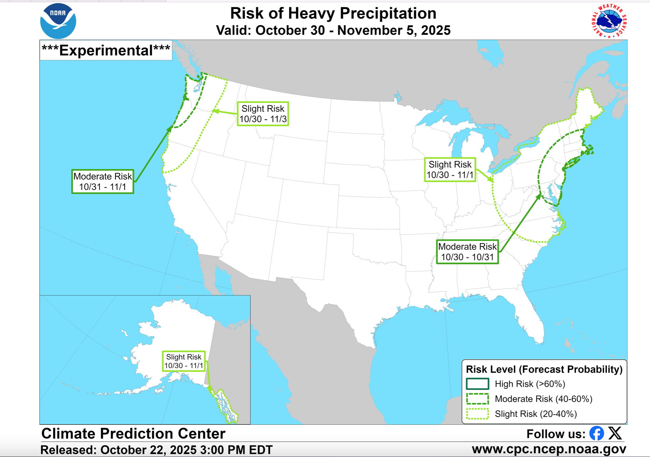
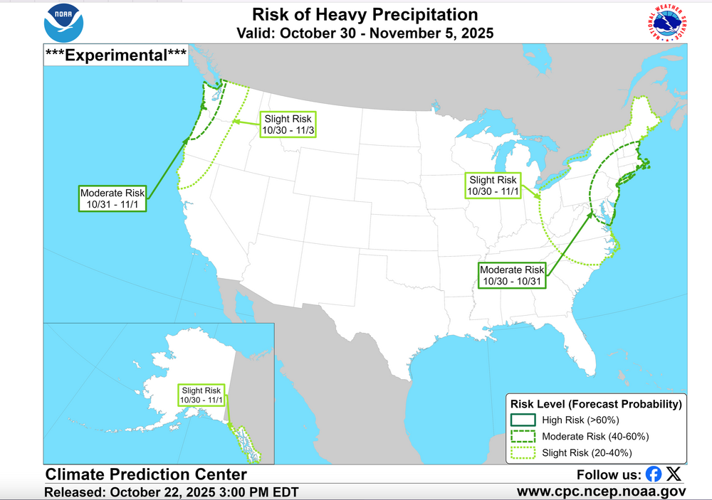
YES... CPC this afternoon continues MDT RISK heavy rain our area. IF I had to make a decision at 5PM today, I would not thread. Too much uncertainty on anything more than 1/4". Upper 5H low needs to form and capture the sfc low. northward along the coast......sometimes this occurs too late. D7 WPC qpf this afternoon is a good start. The CPC 3PM/22 discussion below supports the attached graphic... MDT Risk in my opinion also implies a risk of a miss to the east. The discussion below to the attached graphic. As the troughing moves further east, frontal activity and possible surface low pressure are predicted to bring increased precipitation chances to the East. The forecast is further complicated by the evolution of Tropical Storm Melissa, currently over the Caribbean. Individual ensemble members from the GEFS and ECENS vary greatly with Melissa, with a more west-based track currently more favored in the ECENS. Slower solutions are concerning given the possibility for more frontal interaction with the upstream trough. Today's ECENS and deterministic ECMWF solutions have trended more to the east compared to yesterday showing enhanced precipitation across the northern Mid-Atlantic into New England. While the uncalibrated ECENS indicates at least a 40 percent chance of day 8-10 (Oct 30-Nov 1) precipitation totals exceeding 1-inch over these areas, the GEFS generally keeps chances closer to 20 percent. While uncertainty remains high in regards to the exact evolution, especially in regards to any tropical cyclone interaction, a moderate risk for heavy precipitation remains highlighted across portions of the northern Mid-Atlantic and Northeast, Oct 30-31 considering the timing includes Halloween and potential for adverse impacts to outdoor events. A slight risk of heavy precipitation continues through Nov 1, with the slight risk of high winds extending across the Great Lakes, Northeast, and Mid-Atlantic through Nov 1.
-
ECAI - 12z version continues as previously 10/29-30... almost 2" in NNJ. LOOOOONG ways off and best to play it conservative. 12z once cycle trend on non event GFS/CMC is decidedly north! One cycle D7-8-9. What it does do-lends more truth to the independent CPC perspective yesterday as well as EPS suites... even if those suites are 50% too wet. May? be starting a thread tomorrow afternoon for enough rain to raise Oct amounts to normal or above by 10/31 and a period of gusty e winds 45-55 MPH on the coasts. Some sort of rain-wind event seems to be coming Oct 28-31.
-
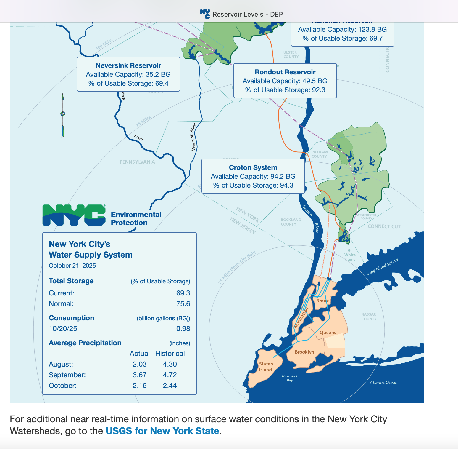
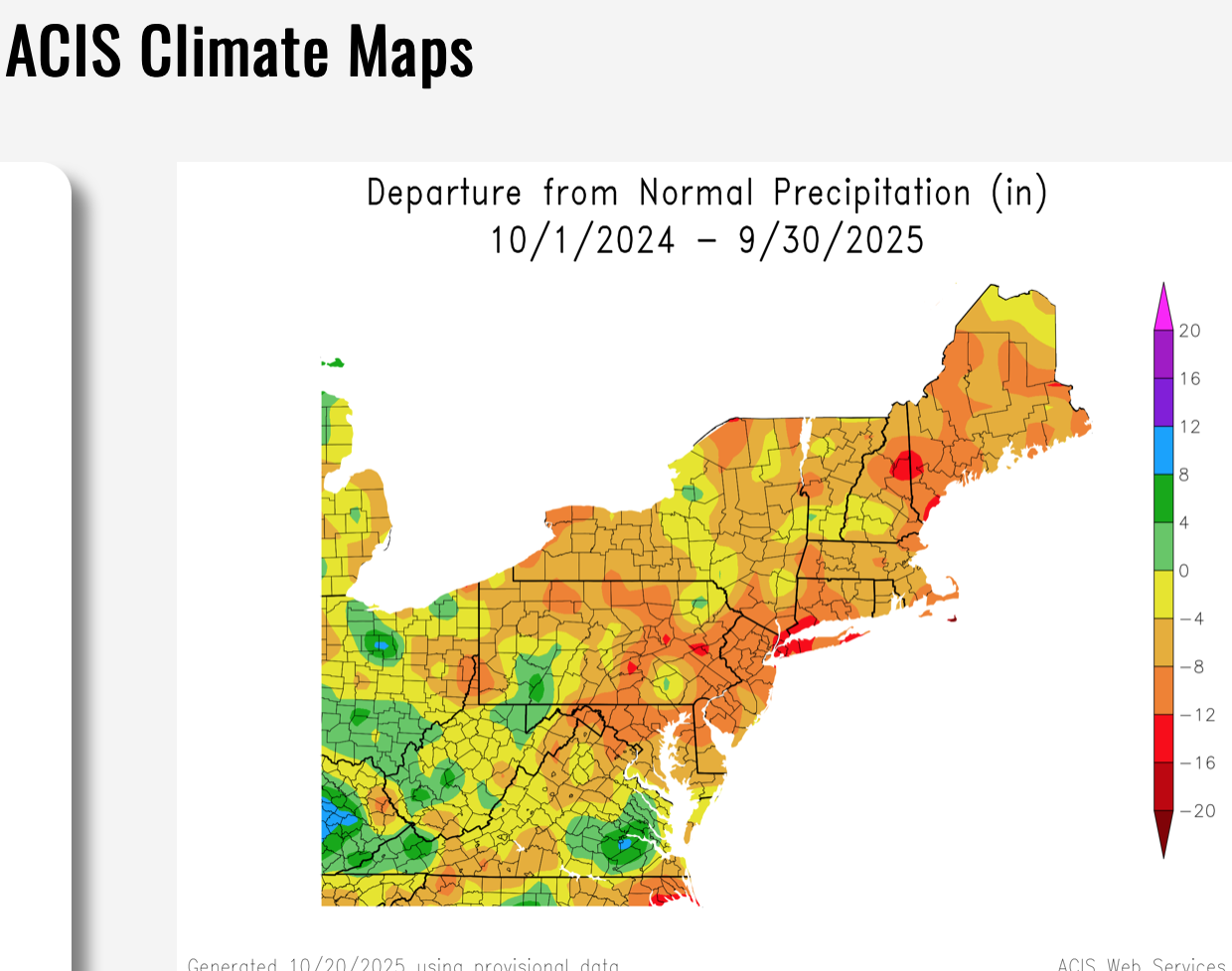
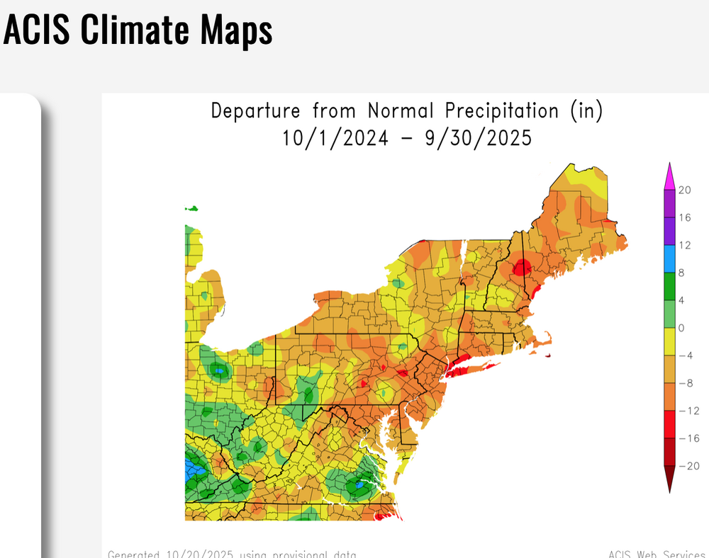
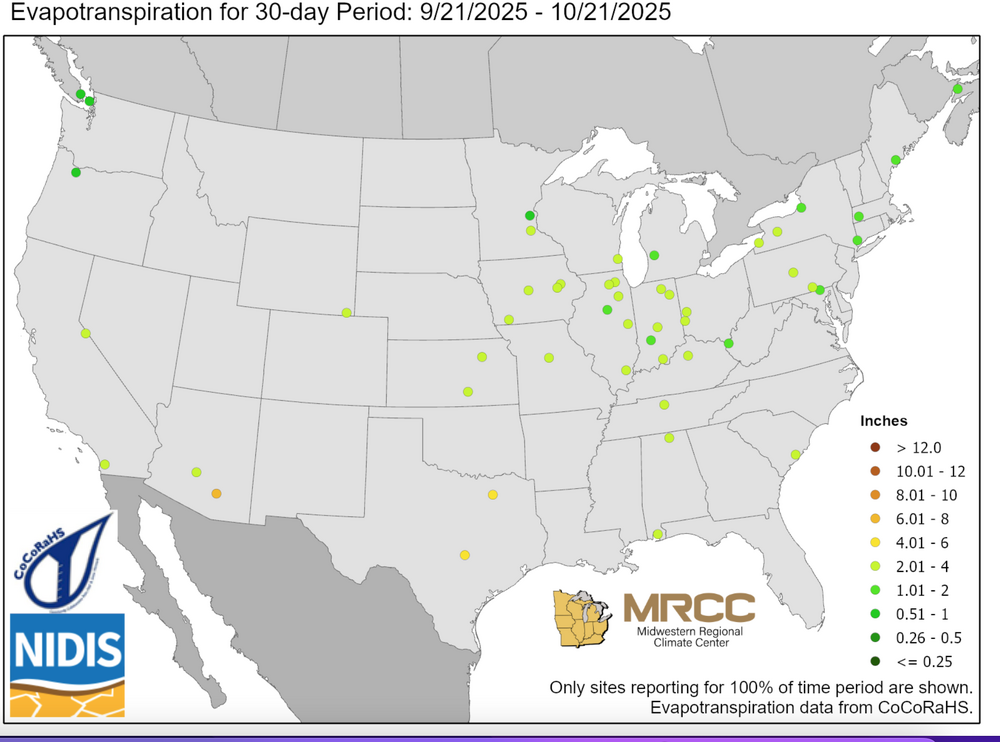
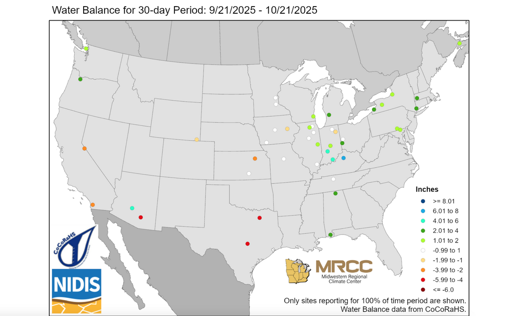
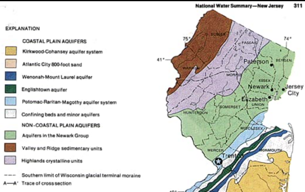
Conversation on ensembles and rainfall brings me to this... Our reservoir levels, I think, are within tolerance, considering the drier 12 months period of I guess roughly 5-10" below normal. Yet NYC reservoir only 6% below normal. The ET and water balance maps are added here to show at least in my mind, where all the parameters are met for objective analysis (including solar radiation)... much less concern, in my mind, for drought up here. Note the positive balance up here vs the drought in TEX. Spring summer are critical here... spring for the typical prescribed burn wildfires in s NJ, and then growing season for farmers. Arguments for rainfall can be made for fall color as well as other concerns (bugs etc) Anyway... if we go another 12 months significantly below normal rainfall...especially next spring-summer, then my concerns are heightened.

-
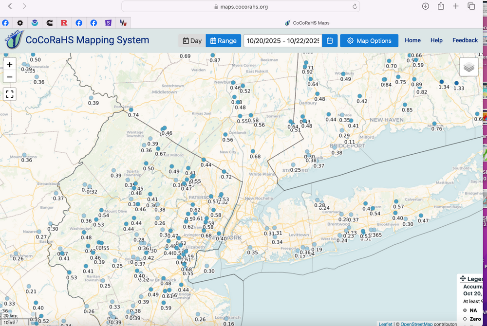
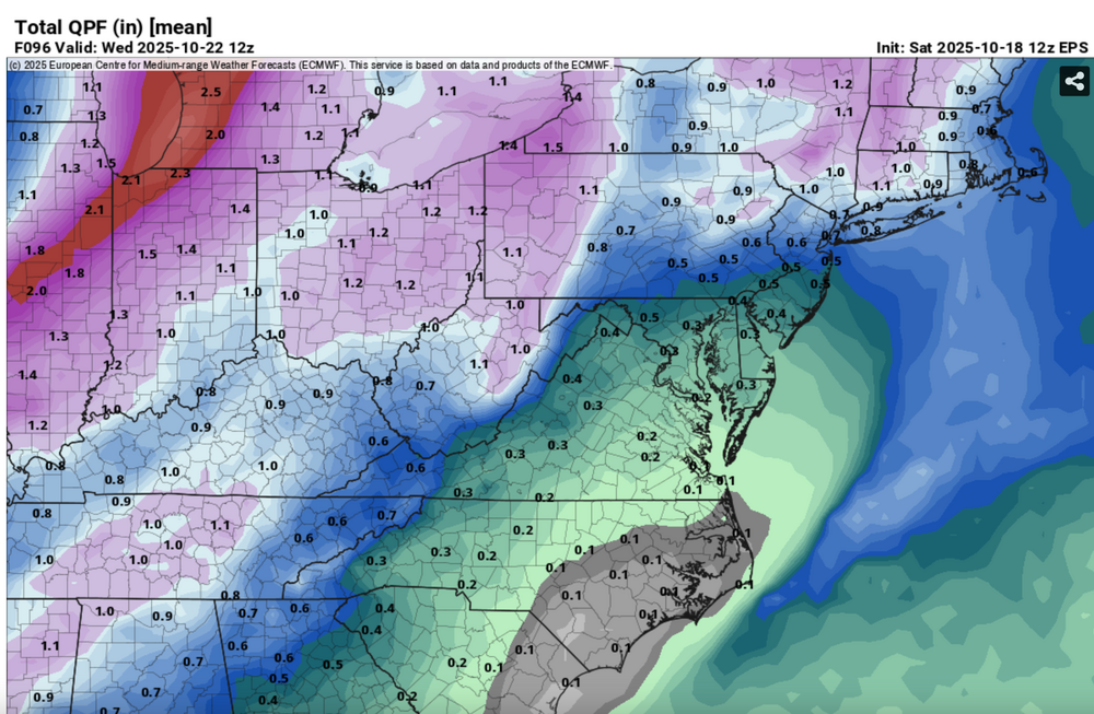
In my opinion this above is misleading. EPS and EPSAI for 10/28-31 are substantial... in addition the modeling shown here is Operational. Operationals are not the most likely solution... one member of many. The two event rainfall ending this morning compare to the ensembled EPS two day event as shown below. Imperfect but reasonable. That's a short 84 hour compare. I cant go back further on the EPS. In this case, the first event was less than modeled, the second more. Modeling tracking differences occur, but the forecaster community does not rely on operationals for overall decision making. I corrected the 10/18 12z EPS to extend to 12z/22. same idea.
-
Also...Canadian block continues through the first week of Nov, and maybe we evolve to a positive PNA by Nov 5???
-
Good morning all, It is a good morning if we can partake in this forum... Widespread beneficial rainfall occurred overnight...into dawn, generally 0.2 to as much as 0.6, from what I can tell. The additional rain we didnt get Sunday night... Regarding what I think are errant 00z/22 CMCE and GEFS runs, the EPS and EPS AI continue on the path of a beneficial 1/4"-2" rainfall for our entire subforum around 10/29-30 or possibly split events 10/29-30 and 11/2-3. No thread on October rainfall equal or exceeding October norm due to very large disagreement between global ensembles. If the ECAI backs off the next couple days then I have to accept a rare win for the GEFS. I'm still always looking at CMCE but in my mind, it hasn't performed very well this year, especially beyond 24 hours. For now, I anticipate modeling to gradually migrate to a northwestward shift and back to the CPC 10/21 3PM moderate risk of heavy rainfall for the entire mid Atlantic coast 10/29-31 Also, all ensemble modeling is offering the first seasonal coatings of snow to the higher terrains of upstate NY and New England. Head into the storm with a steady hand until consistent cyclic evidence directs a change of course (drier).
-
Yellow on. radar scope is moderate rain for sure. .01 in this part of Wantage so far.
-
Continues this morning with the 00z/21 EPS much deeper at 5H than the 00z GEFS, but the 06z GEFS has deepened bug not yet responsive at the surface and resultant rainfall. No thread yet, dependent on la/lo of sfc low and its gradient. It will rain in that period, seemingly Oct 29-30 and may bring October monthly to normal. Too early for me on a thread. EPS twice as much qpf than the GEFS and CMCE so not a lock on a strong system.
-
Overdone EC/EPS late last week for this morning in terms of SE BL inflow and associated rainfall... Block continues into November, even in its weakened state in early Nov. sometime between Oct 28-Nov 3 maybe something pretty strong? No promises and not self evident in the ops. Am back from this past weekend near CMH with bumpy flight return last evening in OH/PA. Indian marriage celebration... pretty cool.
-
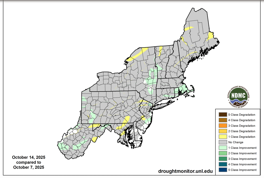
From the past two mornings partially reiterated: No chatter yet on the impact of the block - a block that would be helpful for wintry weather in winter. The block lasts at least through October and now seemingly the first week of November?. I didn't carefully check whether ensemble modeling nailed this 5H blocking, October 1 or earlier? EPS did not have it very well at all for late October. Anyway, while the Ideal Greenland Block shifts westward to Canada...its still a block and will be effective (I think) on sending eastward moving shortwaves Into negative tilt along and south of I80 for our area, the remainder of the month. That should mean additional meaningful rainfall and a couple good storms. Cyclically since at least this past Wednesday, the ECMWF OP CF has a squall line of scattered 45-60 MPH gusts Monday morning, with differing target areas in NJ/e PA/srn NYS. Could be a few power outages/branches down. May not be able to thread in advance but be alert. Bumpy flights eastern quarter of the country later Sunday-Monday morning and some decent 1-3" rains for our subforum Mon-Tue. Saw the drought monitor and you've seen subsequent discussion. I did review the 10 min video provided but not the hour long-yet.
-
Als, ifs anyone is checking... 06z EPS vs GEFS starkly different on digging short wave trough Sun-Monday. Is the EPS far too amped? Think this may be worth keeping an eye on.
-
Hi Matt, I appreciate your honesty! Therefore the thanks for your post. I am now a little more concerned about process. Seems to me this is human interpretation of objective data sets, of which I'm still unclear and can't find that listed in the drought monitor. I like objectivity supplemented with observed impact truths. River flows, reports from reservoirs, farmers, and evaporattion rates. I think there is a brand new graphic available somewhere on evapotranspiration. Any link? Also concerned about overall transparency but that ties with everything in life. Drought here in nw NJ seems to be relatively superficial... when considering acquire recharge. I'm Unskilled at this but not sure what this attached map suggests today. I think those on this forum very much appreciate your shares
-
I could benefit from greater u understanding on what went into this lack of reclassifcation downward in NNJ. The yellow stripes e-w across NNJ? Did River flows influence, or local drought reports? Maybe someone can post the radar analysis or whatever went into the evaluation to support the drought monitor. This will help me curb my enthusiasm for expectation. Thank you.

-
From early yesterday partially reiterated: No chatter yet on the impact of the block the rest of the month? While the Ideal Greenland Block shifts westward to Canada...its still a block and will be effective (I think) on sending eastward moving shortwaves Into negative tilt along and south of I80 for our area, the remainder of the month. That should mean additional meaningful rainfall and a couple good storms. Not sure if anyone saw the ECMWF OP CF-squall line 45-60 MPH gusts, cycle to cycle since 06z/15, different target areas from NJ/e PA/srn NYS early Monday. Could be a few power outages/branches down. No thread for us but bumpy flights eastern quarter of the country later Sunday-Monday morning and some decent 1-3" rains. Latest 06z/16 EC cycle has the surface low driving the CF across the area predawn Monday then redeveloping the deepening sec low s of LI late Mon? Unsure whether this can happen. I'll be curious as to the drought outlook changes eastern NJ/se NYS/CT when it posts this morning.
-
No chatter on the impact of the block the rest of the month? While the Ideal Greenland Block shifts westward to Canada...its still a block and will be effective (I think) on sending eastward moving shortwaves Into negative tilt along and south of I80 for our area, the remainder of the month. That should mean additional meaningful rainfall and a couple good storms. I monitor ECAI my cyclic guide to what should happen as I find it particularly useful on yes/no. Not sure if anyone saw the CF-squall line gusts near 60 MPH vicinity Cape May Monday morning. Whether this occurs as attempted by the 05z EC OP 5-6 days in advance... it's a small possibility. No thread for us but bumpy flights eastern quarter of the country later Sunday-Monday morning and some decent 1-3" rains. I'll be curious as to the drought outlook changes eastern NJ/se NYS/CT when it posts tomorrow morning.
-
I've seen references in news clipping from the NJ coast, 4th or 5th worst tidal level since 2000... that's pretty serious in the past 25 years.
- 731 replies
-
- 2
-

-
- heavy rain
- damaging wind
- (and 2 more)
-
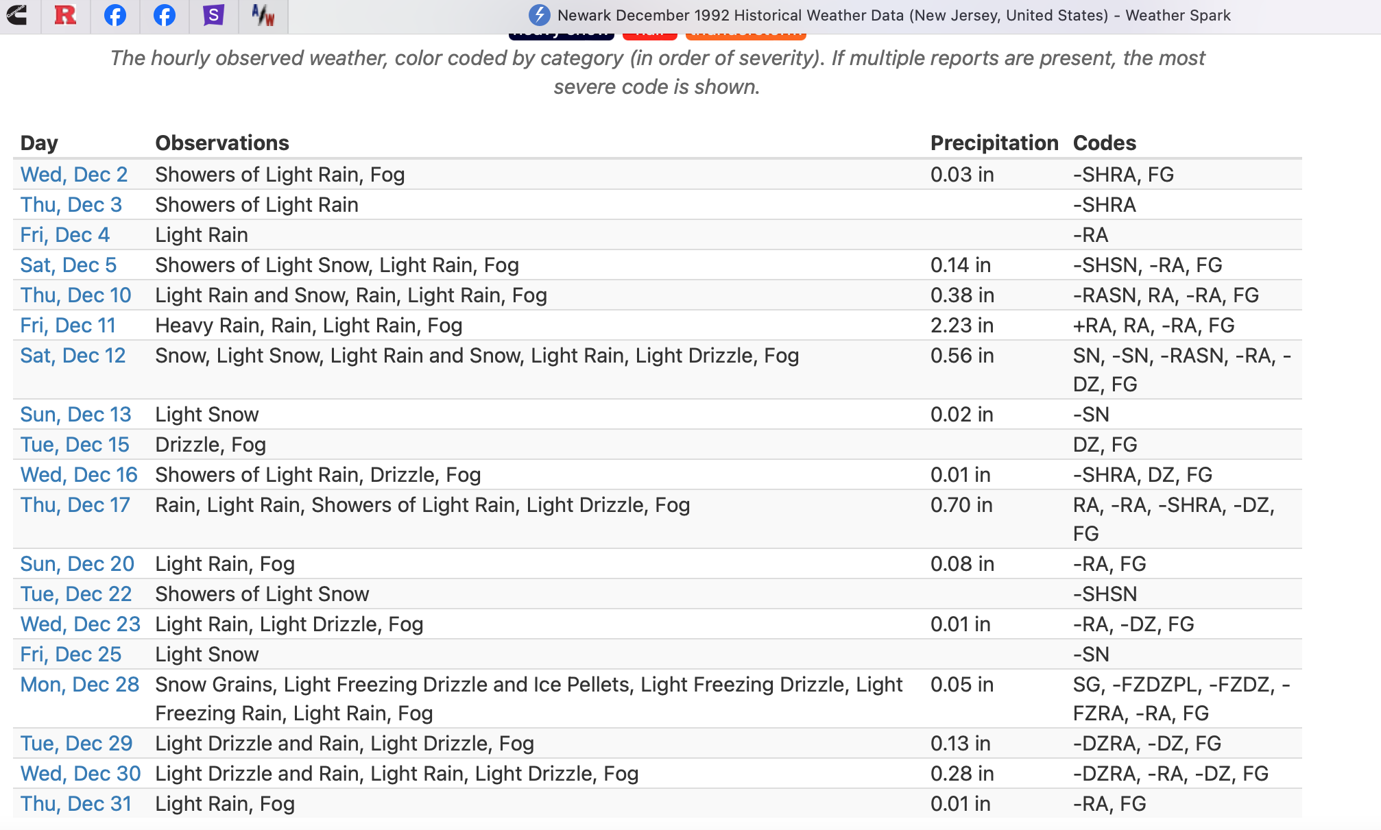
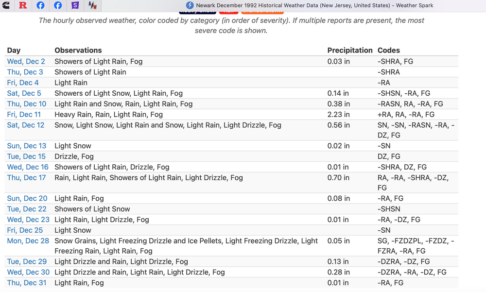
Hi... I'm not going into details since time and my age 75 have lost a little of the edge. From Northeast Snowstorms V2 Kocin and Uccellini. Dec 10-12 1992 was huge... heavy snow most of the interior higher northeast and New England. I was up in Marblehead MA. Powerful there. Mar 11-13 was the Eastern USA Superstorm Coast problems with most of the snow interior I95 westward. Also in Marblehead. The Newark Climate Data for Dec 1992 below describes what happened at Newark Airport... Inland colder and snowier. Coast winds, seas and tides were enormous Dec 10-12 while a snowstorm raged interior. Hope this helps
- 731 replies
-
- 1
-
-
- heavy rain
- damaging wind
- (and 2 more)
-
ARI: Averate Return Interval. If anyone does analysis for October mdt coastal flooding events 5 day MODELED 2-3" rain and G40-60MPH, NON TROPICAL... let it rip. I've seen comparisons to tropical related or winter related. Nothing straight up. I'll check back late today. Thanks for your participation and while not worst case D5 outlooked scenario, and an imperfect nor'easter, most will have benefitted from outdoor cancellations and preparations as well as needed rain.
-
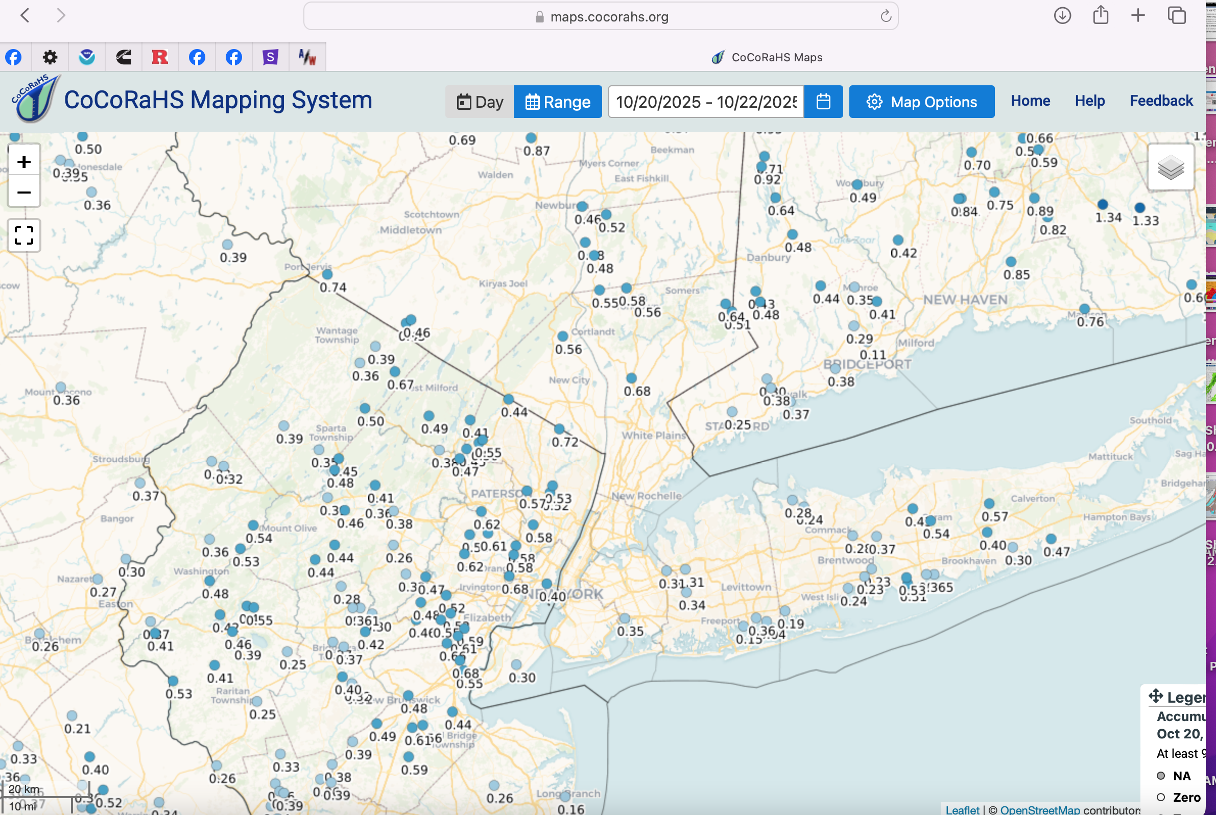
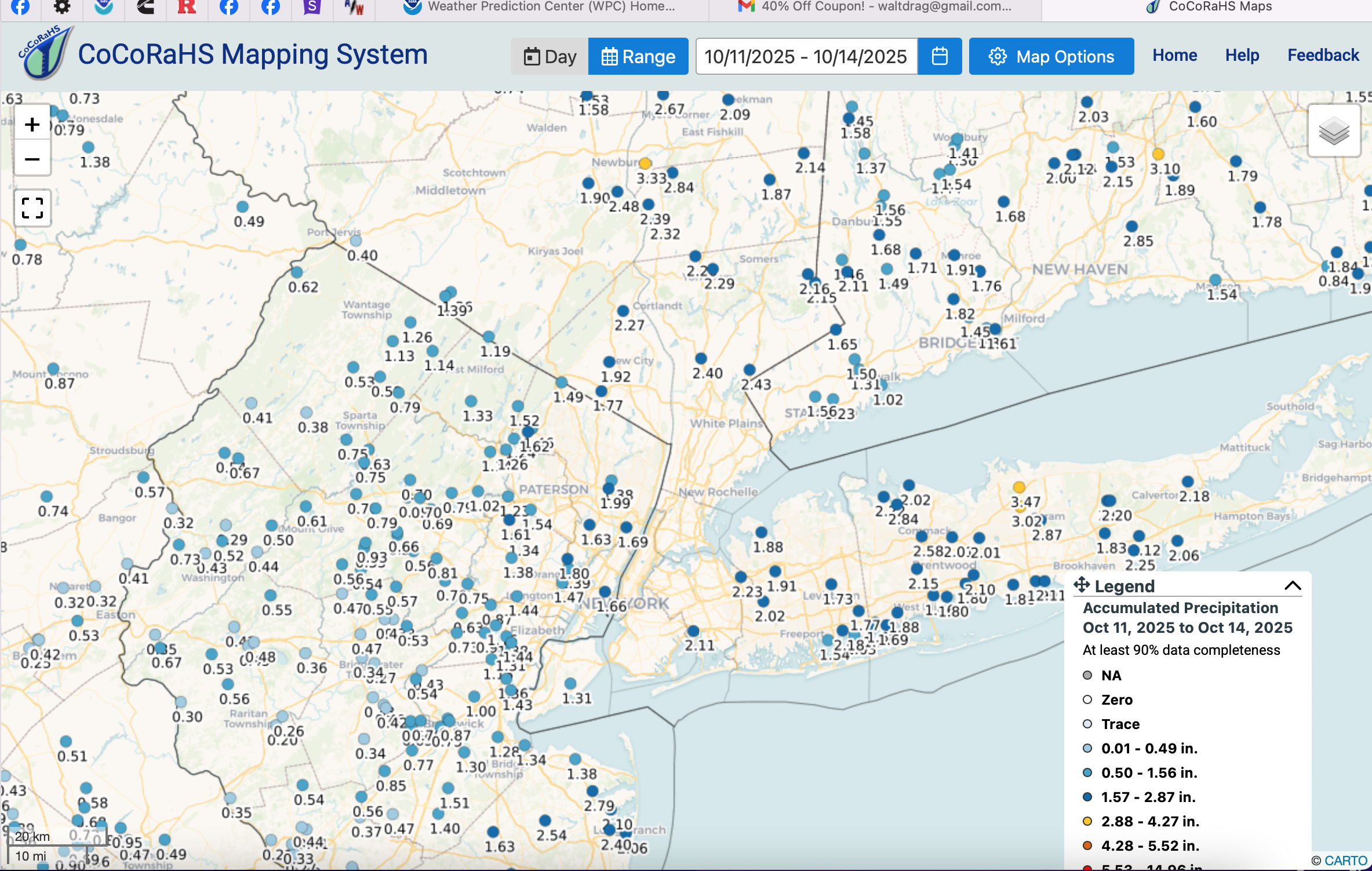
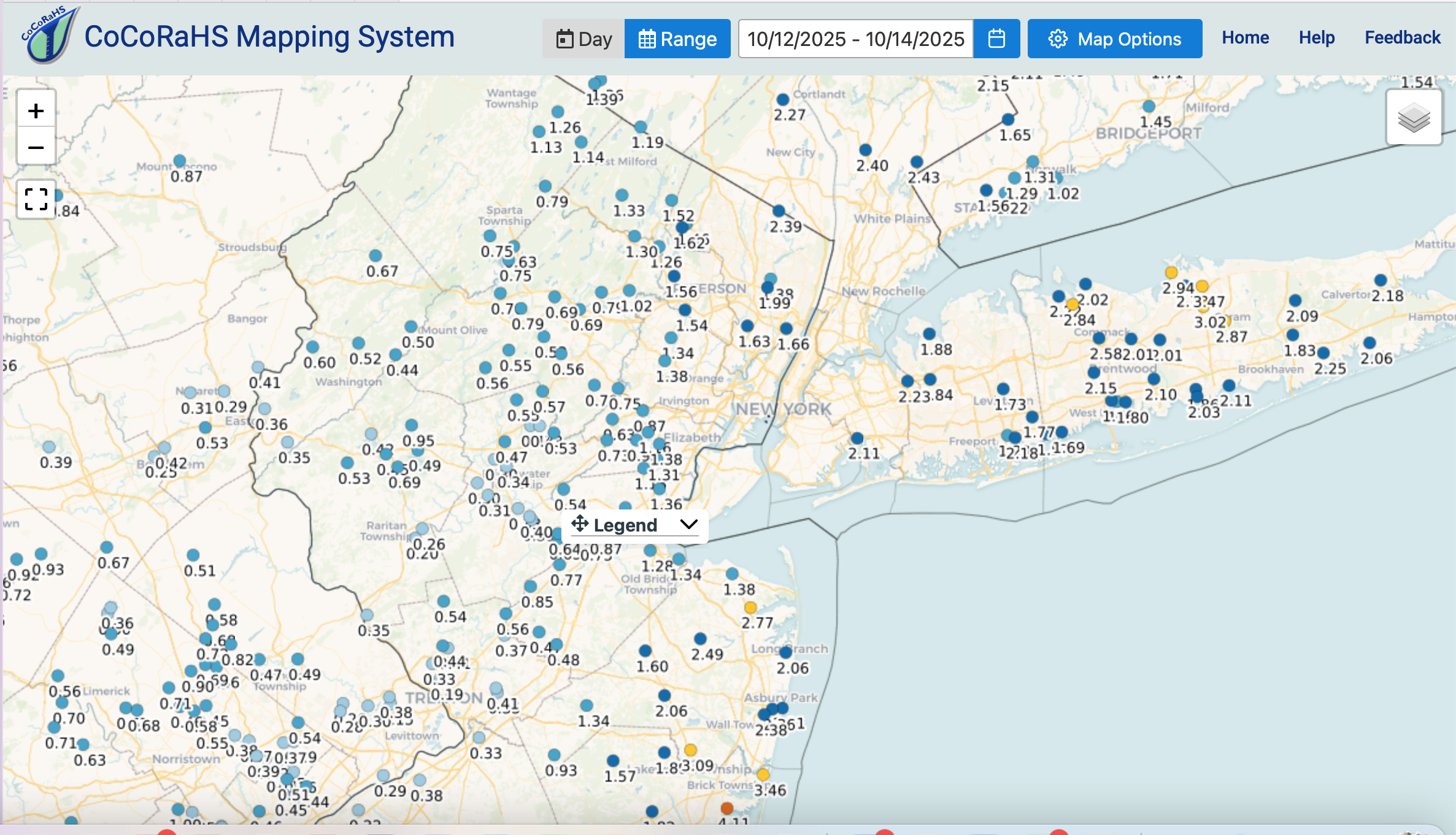
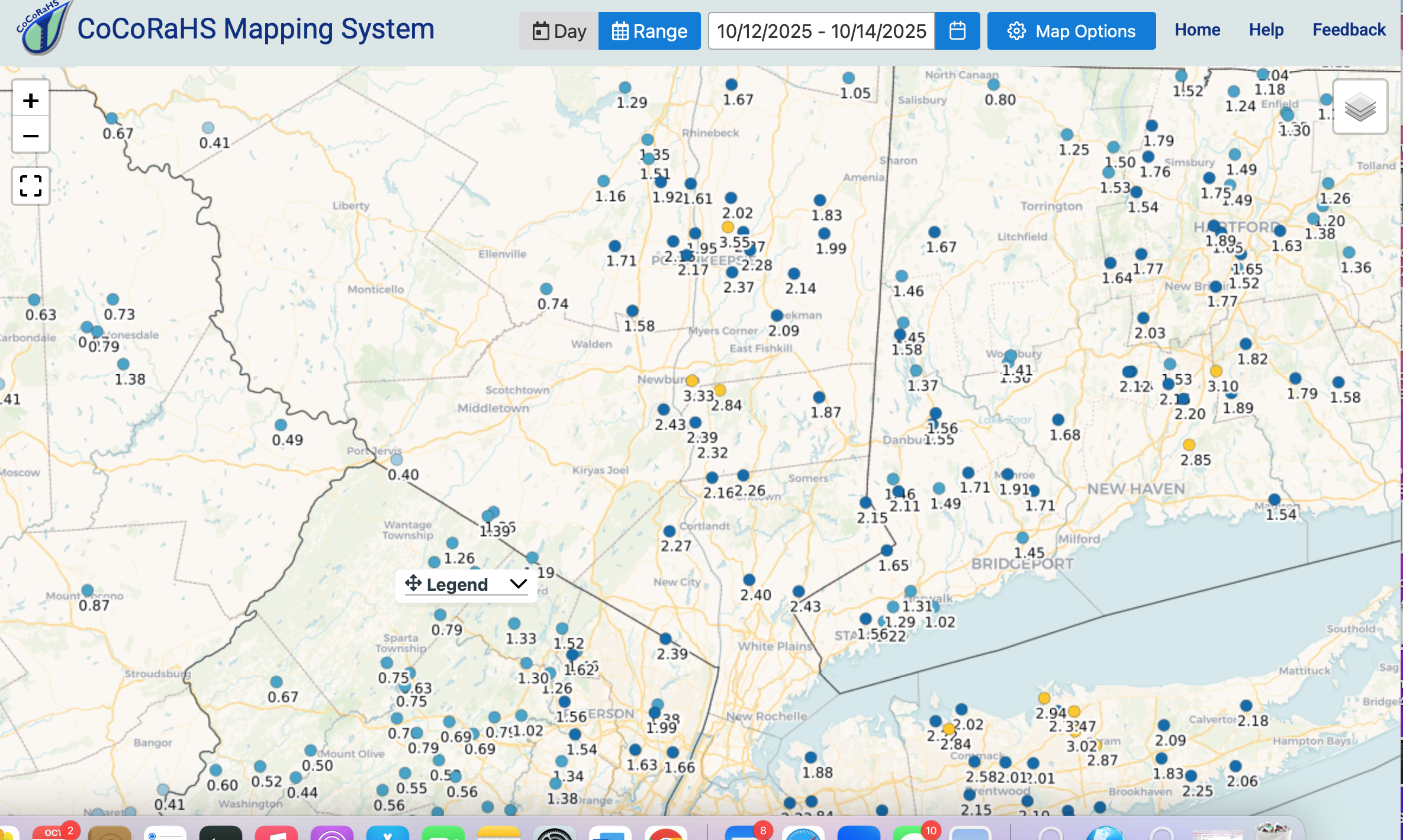
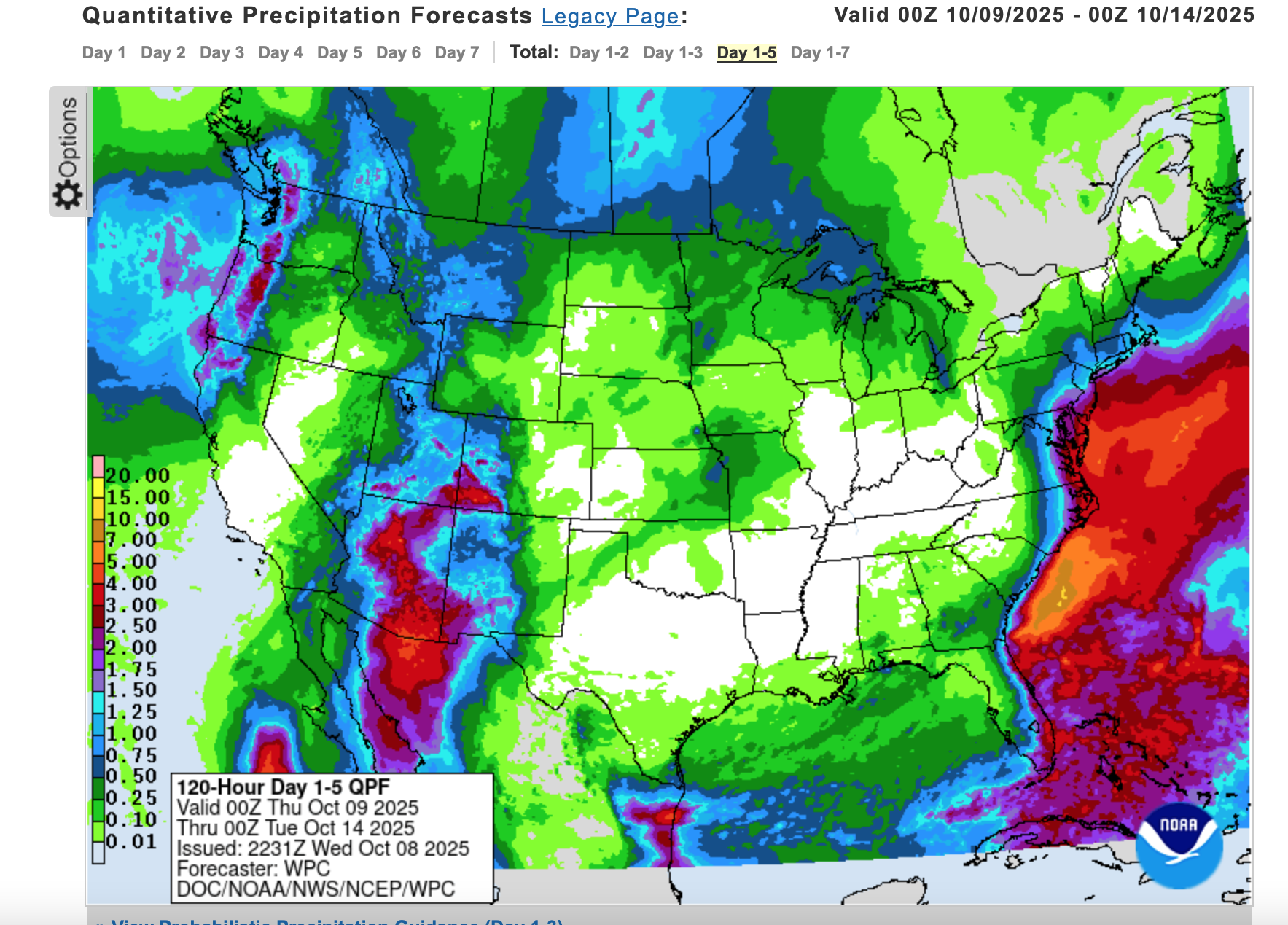
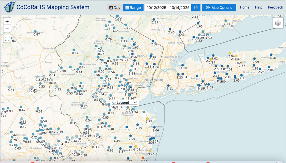
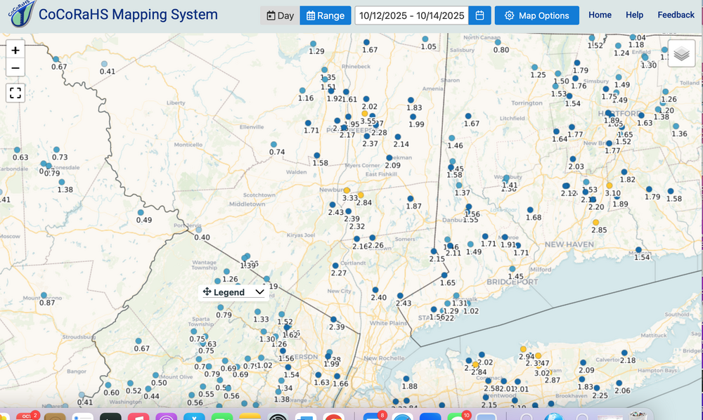
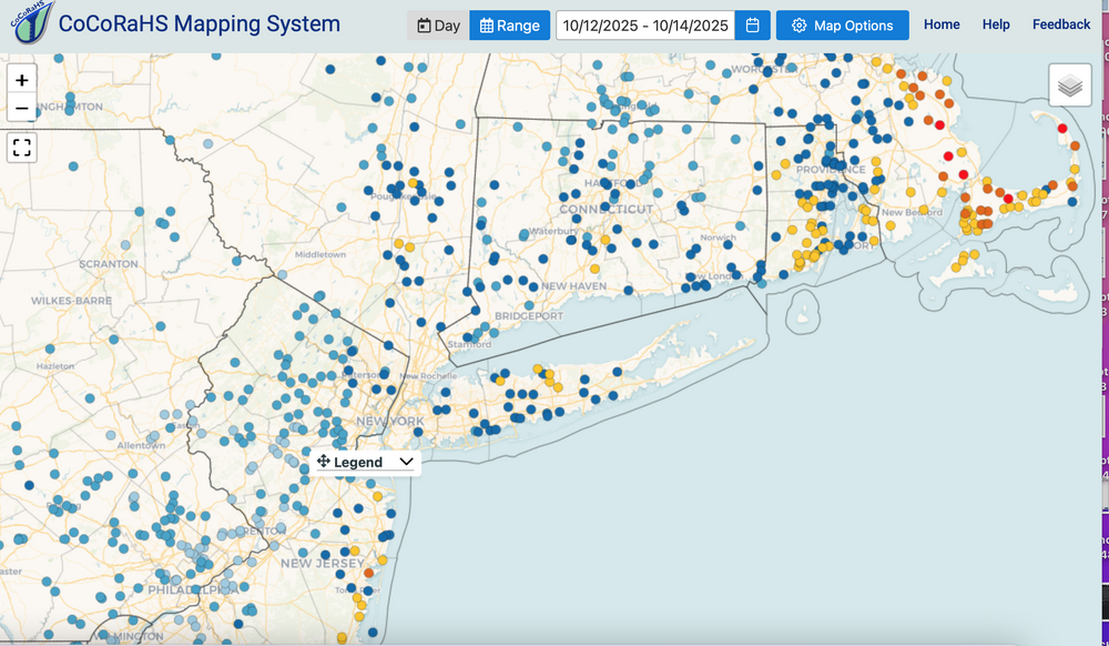
0.37 at my station in Wantage of far nw NJ but the CoCoRaHs 3 day reports and NYS Mesonet show the extent of 1.5-3" that covered, in my estimation about 60-65% of our subforum area with amounts ranging from over 4" in Brick NJ to less than 0.4" parts of western NJ. Also added color coded amounts for the northeast USA, showing the focus of biggest amounts se MA-Cape Cod. Overall, sizable moderate impact, even where amounts less than 1" where intermittent power outages occurred (brief eddy transfer [Richardson #] taking down relative dead wood). Interior eddy downward momentum transfer likely due to fairly strong easterly flow at the top of the boundary layer--always difficult to predict where these spots will occur. If you wish, check back on the WPC 5 day outlook... added below. Actually a little shy up by I84-SNE and I do think this was a one or two year recurrence interval for parts of the coast. ESPECIALLY October NON-Tropical at neap tide. Others chime in with factual info. Please add on OKX and PHI summaries when they arrive. Thank you.


- 731 replies
-
- 3
-
-

-
- heavy rain
- damaging wind
- (and 2 more)
-
I'm pretty much satisfied with outcomes of this storm... p1 if questions...includes WPC 5 day total. CoCoRaHs tomorrow sometime around 915-930. Still some power outages. Officially at least spotty 3 so far Stony Brook LI, and a fair mounts of 3+ Ocean and Monmouth counties in NJ with 3.6+ at Berkeley Heights.
- 731 replies
-
- 1
-
-
- heavy rain
- damaging wind
- (and 2 more)