

Stebo
-
Posts
33,420 -
Joined
-
Last visited
Content Type
Profiles
Blogs
Forums
American Weather
Media Demo
Store
Gallery
Posts posted by Stebo
-
-
1 hour ago, roardog said:
Hope the weight of the heavy snow doesn’t crush his palms. lol
I hope they like near 0 temps
-
 1
1
-
-
-
2 minutes ago, Chambana said:
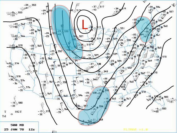
I was going to ask if 1/5/14 “Polar Vortex Blizzard” would be a potential analog for next weeks setup. One of my favorite storms of the last decade. What a beast.
Kind of but the difference is this vort is more pacific originating and dives further south, its a loose analog though with the shape of the setup.
-
 1
1
-
-
Not saying it will happen but the pattern does have great potential
There are quite a bit of similarities to another monster
-
1
-
1
-
-
2 minutes ago, Stevo6899 said:
Gfs looking like you may be onto something...
It will keep changing so I am not going to take a bow by any stretch here, it could easily suppress further south or go back north.
-
Just now, Malacka11 said:
Sometimes is the operational word there. Also, we're under no obligation to tolerate someone whose deliberately trying to piss everyone off just because he can. Even at work it's one thing if someone is just annoying sometimes but if all they do is try to get a ride out of you, that's a different story. Threatening is one thing but idk if that ever really happened
Exactly
-
1
-
1
-
-
4 minutes ago, Stevo6899 said:
It's a message board, not a workplace. Just ignore people that try to troll sometimes. Its not that hard. Not sure why we gotta threaten people on here.
zzzzz
-
1 hour ago, rainsucks said:
meh, I've seen much worse
Ahh yes the unknown poster who is so casual with everyone, I'd watch out before a house falls on you too

-
 1
1
-
-
Nothing but clouds here, everything eroded as it moved east.
-
10 hours ago, Chambana said:
How yall enjoying that no hardypalmguy life?
Its great to not have an interrupting asshole in a bunch of threads.
-
3
-
-
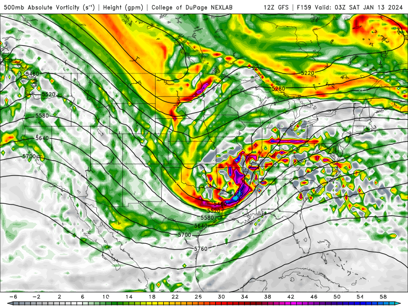
The only issue I have with this projection is that it doesn't make sense on face value. There is blocking to the north with a strong -NAO and there should be some confluence from the Tuesday/Wednesday storm and this one riding right up on its heels. I would expect this to come south and east some over time and the GEFS members are actually much more subdued, even a few that have completely nothing. I just don't buy a storm running right into a block like that and almost moving due north as well. Also too the system this weekend and the one early next week have come south some or in the case of the early next week storm isn't nearly as wrapped up and takes a more NEward trek compared to some of the early model projections. I do still think this will be a significant threat but I would expect a bit flatter of a track. For some people like Missouri and central Illinois the output probably will remain significant either way.
-
7
-
-
1 hour ago, SchaumburgStormer said:
Mine’s the 17th.

I will add my power of Feb 7th birthday, lets get everyone a birthday gift of snow
-
2
-
-
3 hours ago, Stevo6899 said:
Looking like areas east of Chicago, and west of Albany ny, Zzzzz. Typical corridor of mediocrity.
Not sure what you looked at.... but this completely disagrees.
3 hours ago, SchaumburgStormer said: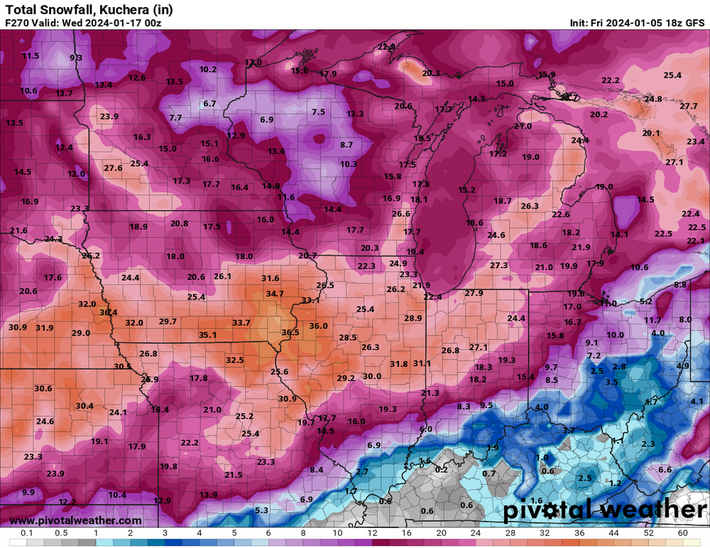
-
20 minutes ago, RCNYILWX said:
Figure the amount of convection in the warm sector is something that may also contribute to struggles in handling the evolution of this system.
Sent from my SM-G998U using Tapatalk
Yeah that is contributing a bit too but with the negative tilt of the storm you'd expect a nice CCB and a nice baroclinic leaf structure to this. Models seem to just struggle with both at this point.
-
2
-
-
I would say these models now that they have gotten to such fine grid scale have done poorly on cold sector precip, I feel like this may be a situation like that as well.
-
4
-
-
44 minutes ago, A-L-E-K said:

OT for a second, this happened to us when I was 15, me and my grandpa were driving behind my uncle and dad going up north for deer hunting and the wheel flew off and up into the trailer itself leaving the rest of the components to leave a scar on 75 for about 100 ft. They ended up welding the wheel onto the harness as the trailer was going up north for the last time and they limped it up north. A 4 hour drive turned into 10 with the repair.
-
2
-
-
BAM weather sucks and always has
-
2
-
1
-
-
2 minutes ago, StormChaser4Life said:
Definitely afraid of a nw trend on this one with how strong the low is. I don't have a lot of wiggle room. Lol. Going to be a nail biter for sure. Key will be how quick trough goes neg tilt and how fast that low takes off because that's when it will start taking a more ne turn.
The main key will be where the high to the east sets up and how strong, and if there is a piece of energy to the north that could help swing the low north and put in some lead edge WAA that could present boundary layer issues. If there isn't a piece of energy to the north and you end up with more of a banana low this could lift northeast and then slide east from there. A lot of moving pieces still.
-
3
-
-
I'm fine with this thread though I would have waited a couple more days. That being said there will be a storm for the region in the period, the devil is in the details and will be for a while as we still have the storm to go south of most of us this weekend.
-
2
-
1
-
 1
1
-
-
32 minutes ago, A-L-E-K said:
free cromartie
No, and stop going to bat for the worst of the worst, Christ.
-
1
-
-
18 hours ago, Brian D said:
BTW, I'm assuming we no longer have a troll issue. That will be so nice.
10 hours ago, WestMichigan said:I missed that. Is he gone?
Yes for now, me and a few others are watching to make sure it stays that way.
-
3
-
-
1 hour ago, michsnowfreak said:
Detroit finished December 3rd warmest on record, behind only 2015 & 1881. The snowfall of 0.1" ties with 2014 for 2nd least snowy December, behind only 1889. Season to date snowfall is 2.5"
The calendar year 2023 finished with a mean temperature of 52.6°, which is the 7th warmest year on record (behind 2012, 1998, 1931, 2016, 2021, 1921).
Precip totaled 36.65" which is around a foot more than 2022, but snowfall only totaled 32.1" which is around a foot below 2022.
I think the crazier part about this other than 3 of the 6 are in the last 11 years, is that 2023 did it while not really even getting hot in the summer. That is more concerning than anything if you ask me.
-
1 hour ago, weatherbo said:1 hour ago, Muskegon Mauler said:
If you read the forums and get to know a poster’s style their sock accounts are obv.
Something needs to be done about this, IP ban him or something.
-
1
-
1
-
-
2 hours ago, A-L-E-K said:
Waiting for stebo to greenlight
I think we wait until tomorrow for the first system for this weekend, and then probably mid to late week for the big system
5 days or less is a good window for a thread start.
-
1
-
1
-
Winter '23-'24 Piss and Moan/Banter Thread
in Lakes/Ohio Valley
Posted
This is sad really.