

Stebo
-
Posts
40,251 -
Joined
-
Last visited
Content Type
Profiles
Blogs
Forums
American Weather
Media Demo
Store
Gallery
Posts posted by Stebo
-
-
2 hours ago, KokomoWX said:
I hate this world.
Hi, I see myself from yesterday in this image
-
4 minutes ago, SchaumburgStormer said:
Stop me if you've seen this before, but the NAM is a north outlier.
Just now, CheeselandSkies said:Not as much as the HRRR, though.

There is actually a reason why, and if it does come to fruition it would bust most areas. It amplifies a lead head of the vort in the north forcing a low to the north.
-
 1
1
-
-
5 minutes ago, RCNYILWX said:
Plan is for me to do the forecast for the storm today. Definitely a risk with ptypes into the metro, though recall that GHD II started out pretty warm too. So hopefully we find a happy medium. The Chicago shore could be a bigger issue again.
Sent from my SM-G998U using Tapatalk
I wonder if you will use the phrase "white rain" for this area

-
2 hours ago, A-L-E-K said:

You had me until you posted this, SREF is garbage and you know it.
-
 2
2
-
-
1 minute ago, mimillman said:
This should be significantly better than the last system as currently modeled for the immediate metro. 0c 850mb barely gets into southern cook county and has an E/W orientation at the storms peak while the last one had 0c 850 into DuPage and Lake counties. 925mb was also well above freezing in the last storm. I’m not ruling out a jog north which could put that in jeopardy, but as progged it is a different ballgame. Ratios will be very poor, probably 8:1 type.
The lake isn't your friend with this storm. It's going to be a white rain downtown more than likely.
-
12 minutes ago, A-L-E-K said:
big pattern change looking like it could produce a couple rainers followed by CAD
not an ideal follow up to december imo
It would almost guarantee a below normal snow season here because cold and dry doesn't yield much snow even with some lake effect.
-
2 minutes ago, SolidIcewx said:
Hopefully can get a few inches out of this. Would be unpleasant to have an arctic air outbreak with barley any snow on the ground
Yes I think a few inches is maybe possible but I can't go above 4" and honestly that might get washed away by rain too, just like yesterday.
-
The atmosphere is pretty similar to the current storm with this one. Idk why you guys think a bust potential isn't there with essentially the same storm again especially in the city of Chicago. Joe is seeing it so is Alek.
-
Just now, mimillman said:
Honestly when all is said and done with this, best place to be will probs be south central Michigan.
Nah this storm is going to go west and make sure it clubbers Chicago while it rains again here.
-
1 hour ago, mimillman said:
Stebo is gonna love the 18z ICON
Oh yeah totally love it. At this point I'm just going to stop talking about this storm because the minute I say anything it blows up in my face. Congrats Chicago
-
8 minutes ago, andyhb said:
Eh? The Euro/EPS is stronger because the primary shortwave is deeper and more organized than on the GFS, not really due to phasing.
The Euro being overamplified as usual.
-
Just now, Malacka11 said:
I know it doesn't mean jack diddly but wasn't the current storm also Euro NW and GFS SE by a bit and then the GFS trended into agreement? Or am I IIRCing wrong
Euro/NAM had it tracking north of you guys or right over. The low is in Central IL where the GFS had it.
-
 1
1
-
-
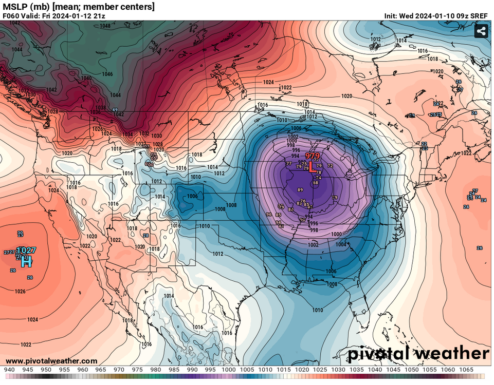
Still overamplified, its not hard to understand with minimal phasing that we aren't getting a sub 970mb low. Remember what today was supposed to be, in the low 970s and right now its about 10mb weaker than that.
-
Thankfully its on its own and realistically it should have been weaker, the trough was faster and flatter but somehow still wrapped up.
-
3
-
 3
3
-
-
Just now, Stevo6899 said:
I am not your sweet summer child and I dunno what 10 hours you are referring to lol. While detroit always seems to get in on pingers, I don't recall having 10 hours of it. I remember ghd 11 was a few hours.
It could be when he has lived down south

-
1
-
-
26 minutes ago, hawkeye_wx said:
I'm at 7.3 inches. Heavy bands are expanding over me, so we have a real shot at 10 inches. It's a beautiful snow, too. Wet, but fluffy.
Good to see you cash in
-
8 minutes ago, Chambana said:
Emotions will be running high because of the amped up solutions, as stebo alluded too, lots of moving parts, that are just now coming into focus. Obviously everyone wants the historic blizzard, BUT a spread the wealth that drops 6-9” with 30-35mph winds is still awesome to me.
Yep we all deserve a nice hit.
-
4
-
-
15 minutes ago, Chicago Storm said:
wasn’t a forecast, just a thought.
you’ve gotten pretty bad these days. might be time for a post 2016 election hiatus for ya. sounds like he is past his prime, like the Euro.
-
1
-
-
2 minutes ago, CheeselandSkies said:
So the question is, why does the guidance (across multiple models and multiple ensemble members) keep showing them until relatively close in time?
Still a ton of moving parts one would expect the Euro to come down some this upcoming run though.
-
2
-
-
Just now, mississaugasnow said:
Isnt that better for SE MI? Im routing for a slightly weaker more SE trend. A stronger storm is just a redo of this current one
It is better for here than the Euro.
-
2
-
-
6 minutes ago, Chicago Storm said:
as nice as it would be to get the dog some guidance has shown, odds are this one will favor southeast of here, due to the evolution of things.
sort of a late developer for here than you’d normally see.
.Yep, like I mentioned earlier, it will still be a good storm and most will get a good hit but these sub 970mb lows are a pipe dream, just like they were for the current system.
-
5 minutes ago, StormChaser4Life said:
Hoping it won't end up more suppressed like the 06z gfs run and miss a lot of the nw subforum. Need a nice spread the wealth storm for us.
I would like that too, everyone wins everyone is happy. Today is pretty much everyone loses no one is happy.
-
1
-
-
2 minutes ago, geddyweather said:
Been wondering this the whole time tbh. As much fun as it's been to watch, the climatology part of my brain has been rattling with the fact that it's just so unusual to see such an amplified system in that part of the region. Not saying it couldn't happen, but given the current background state (system today + disturbance Thursday + eastern ridging possibly playing a hand too) and past history, does it make sense?
Yeah I am not saying it can't happen either but looking at how the models handled the current system one would have to think the Euro is overcooked.
-
2
-
-
Definitely don't like the Euro overamplified look, but I will say it was overamplified with the current system at this junction too. The GFS is probably a more reasonable solution just because the rarity of getting a low as strong as the Euro that far south and the GFS did pretty well with the current system where as a lot of other models had the low further north.
-
2
-

Winter '23-'24 Piss and Moan/Banter Thread
in Lakes/Ohio Valley
Posted
Not in a Nino, which is why if we don't get much Friday that would almost seal it for a below normal snow for the season. You can't just punt Dec and January and hope that Feb/Mar pay off.