

Stebo
-
Posts
33,420 -
Joined
-
Last visited
Content Type
Profiles
Blogs
Forums
American Weather
Media Demo
Store
Gallery
Posts posted by Stebo
-
-
6 hours ago, cyclone77 said:
Some kind of sociopath. Gets off on trying to make people feel bad.
Honestly yeah, like its one thing to like warm weather, but to constantly troll about it while never adding analysis and constantly interjecting into good conversation with garbage it was time. It was time when he came back after being banned to begin with but previous moderation ignored the problem here.
-
 3
3
-
-
Everyone knows Cromartie sucked
-
 4
4
-
-
14 hours ago, michsnowfreak said:
Yup exactly. December 23 palm guy out, December 23 mittenwx in. The new England moderators will gladly assist in removing trolls if need be, so assuming mittenwx is cromartie (Brown City, nice touch
 ) the leash will not be long.
He is gone, it was him.
-
2
-
1
-
-
3 hours ago, Chicago Storm said:
the useless cfs, posted with love for our wisconsin brethren…


.Pretty sure he ate it and weirdly enough mittenwx showed up the same day with the same vibe.
-
1
-
-
I wish we had 4-6" all year at this point.
-
2
-
1
-
-
6 hours ago, SchaumburgStormer said:
Was CRUSHED with 1.7” out of that WSW
Yeah we didn't much here either.
-
21 hours ago, michsnowfreak said:
Interesting thoughts. You think a weaker SSW would favor colder but LESS suppression than a strong one?
I mean a weaker SSW should be colder than what we have been dealing with.
-
23 minutes ago, Spartman said:
I would disagree that it is backing away, weaker sure. But I actually don't mind a weaker SSW event because I don't want to go from warm and dry to cold and dry. A strong SSW could easily be suppression city.
-
1
-
-
3 minutes ago, mittenwx said:
A look into history does not guarantee the same path in the future.
It's the UP man, if they aren't getting snow its extraordinary
-
1
-
-
1 hour ago, mississaugasnow said:
Going to be real tough for the Great Lakes to see average ice coverage as well.
That's more than fine, I'd rather have a warm spring than not.
-
3
-
-
1 hour ago, Jonger said:
November was 0.3 colder than December.
How often does that happen?
Never
-
4 hours ago, weatherbo said:
Reporting icy driveway conditions in the UP.
.thumb.jpg.f0b4f4c2623c0a61193602d8429a2238.jpg)
Looks like September
-
 1
1
-
-
56/49 yesterday, 49 obliterates the record high minimum by 6. 56 was 21 above normal and 49 was 26 above normal for a 23.5 above normal day. The month is now 8.2 above normal as well with still a few more above normal days left in the month. We will probably end up around +9-9.5 with the positive departures left in the month.
-
As for the rest here from the last few days, good stuff and you can already see some hints of the change in the longer range. I still worry about going warm and dry to cold and dry but beyond that it does look colder about a week out from now.
-
On 12/26/2023 at 6:41 AM, A-L-E-K said:
Zzzzzz
On to February
Could you be any lazier? Like if you don't care about someone spending time making a good post, don't reply.
-
3
-
-
23 hours ago, weatherbo said:
A few nibbles and a couple small perch, nothing I kept. Up until 1998 Teal was the source of drinking water for Negaunee. It has remained a motorized free lake so not very popular for fishing in the non-winter months. There's some nice perch, walleye, and crappie. In the summer I fish the coves from my yak and have taken some nice bass.
Woke up to 37 degrees, fog, with just patches of snow left. Hard to believe it's Christmas Eve.Nice perch is always good eating.
-
9 hours ago, weatherbo said:
Low of only 33 overnight. Might be my last day on the lake for about a week. Ice is 4 inches but getting a little soupy.
decent shot at some lake enhanced snow in about 5 days. 1.5” of snow left up at the house.
How were the fish biting, also what do you catch in Teal Lake?
-
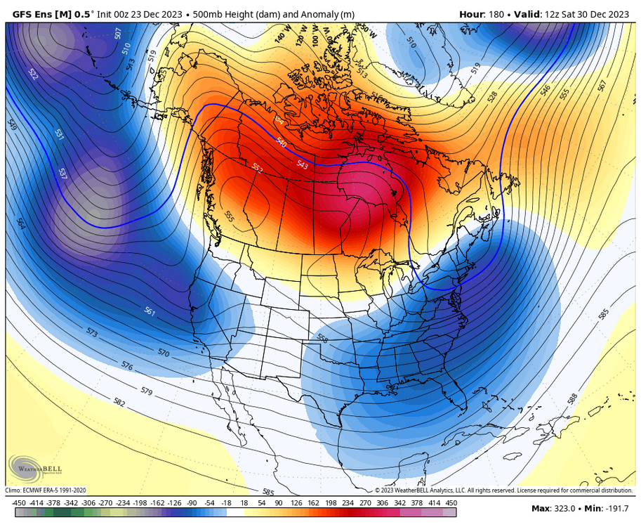
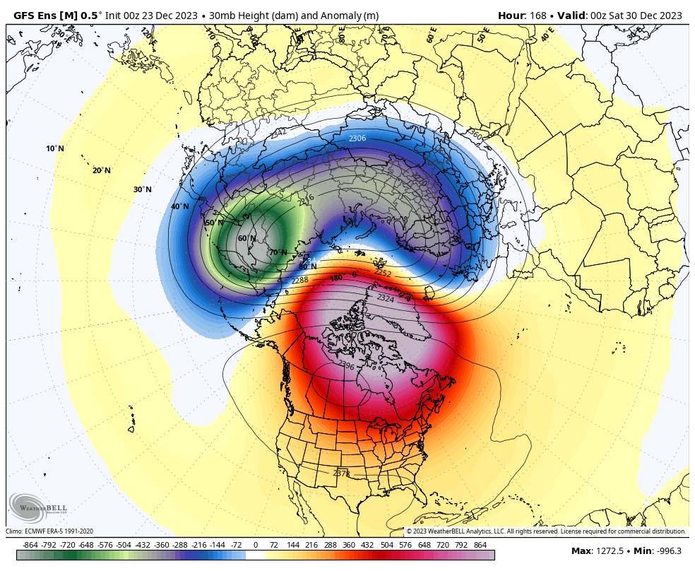
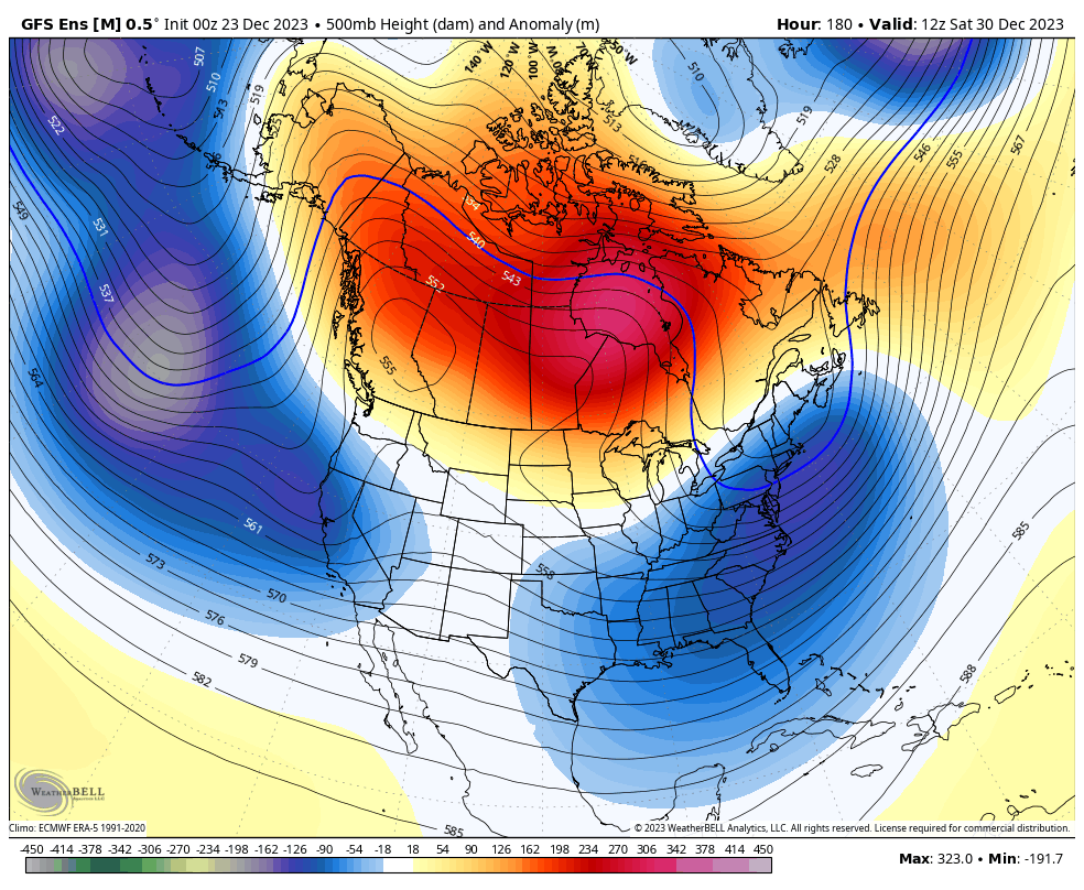
5 hours ago, Chicago Storm said:
As has been mentioned, we are heading into a significant pattern change. Changes on the large scale really start to appear this weekend and into the beginning of this upcoming week. This new pattern, which may very well evolve over time, will extend through the first 1/3rd of January, and quite possibly the first 1/2 of January.
Two big changes that we are seeing right off the bat and that have already begun are a progression of the MJO into the colder phases and a stratospheric warming event. The MJO recently entered the COD, after being in low-amplitude warmer phases from the very end of November through the first 2/3rds of December. The trip through those warmer phases is one of several reasons (Raging Pac Jet is another) that we have been stuck in a consistently mild (Sometimes very mild) regime. The MJO has now entered a colder phase, low amplitude phase 8, and is expected to make a trip at lower amplitude roughly through colder phases 1-2 over the next 1-2 weeks. Another thing that we will be watching unfold is stratospheric warming. This event is expected to disrupt the main SPV placement and strength during the potentially 1-3 week event. As is usually the case, any effects of the SSWE will not be seen right away; that is something to keep an eye on from around week 2 in January through early February.
.png.3a89226efde1d366c1eaa9979c7493ee.png)

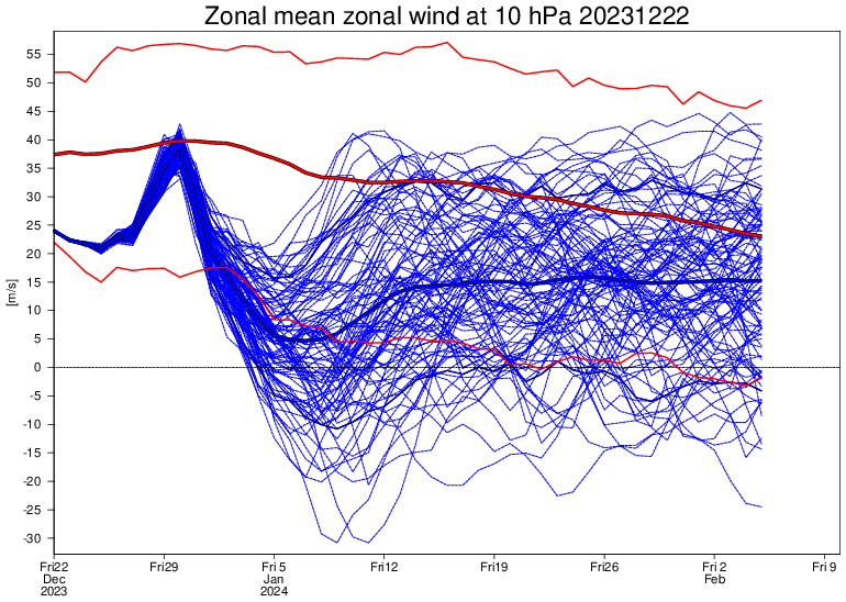
As mentioned above, there are a few reasons we have been seeing consistently mild (Sometimes very mild) conditions over the past several weeks. The raging Pacific jet is one of those bigger reasons. The Pacific jet is expected to break down soon, with increased troughy-ness (Wave breaks) developing. Canadian ridging, which will retrograde from Central to Western Canada and eventually Alaska, will also tend to lower Pacific influence as well.

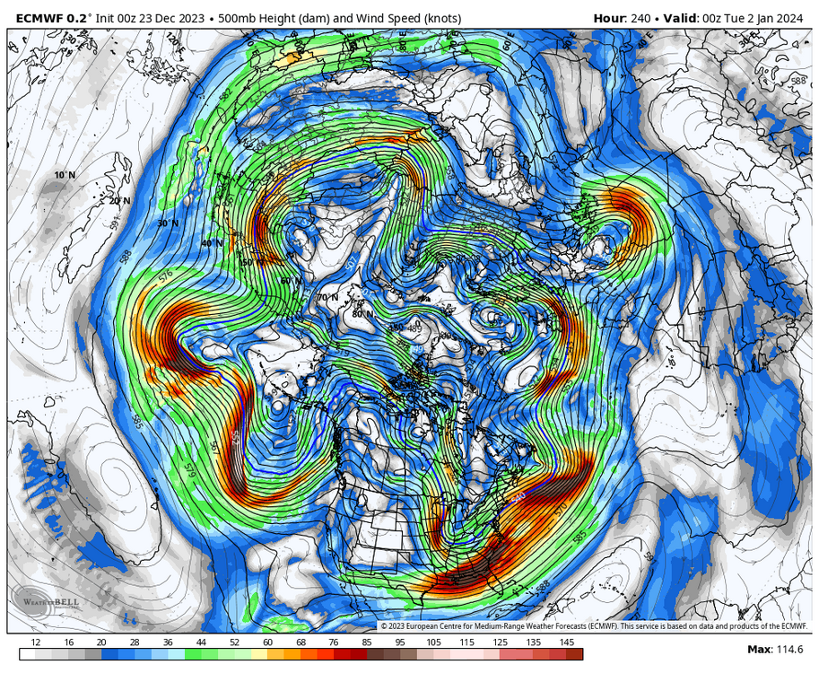
Getting beyond the MJO, SSW and Pac jet... We are likely to see a fairly consistent flow of waves/disturbances/troughs enter the CONUS along the West Coast, originating from the deep/mean trough from the Aleutians down into the Northeast Pacific. This is characterized by the lower-height anomalies from the Northeast Pacific and then across the southern 2/3rds or so of the CONUS. Additionally, with the Pacific jet breaking down and the retrograding ridging in Canada, this will lead to generally cooler/colder conditions overall than have been seen, with an airmass origin more often than not from the Northeast Pacific to Pole regions.
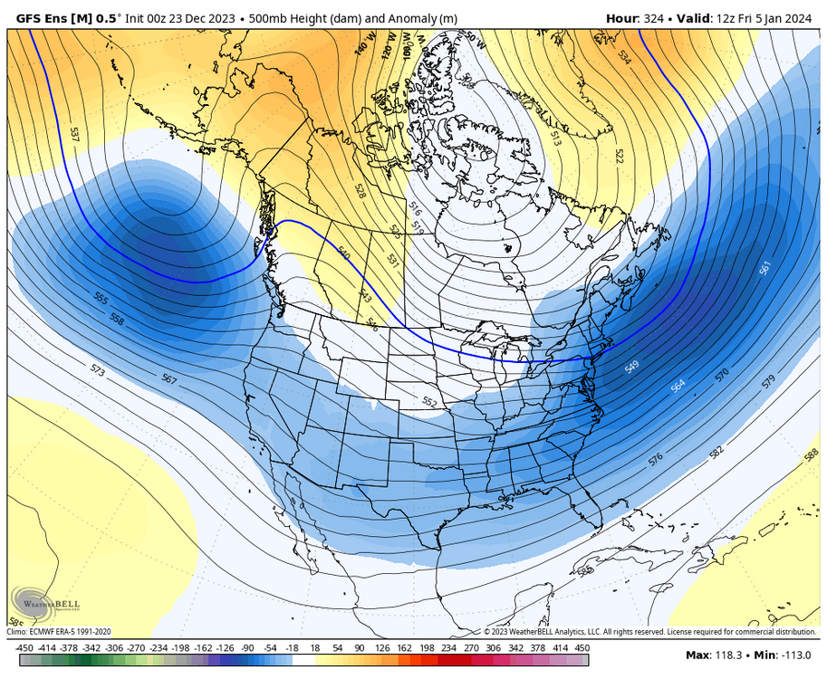
All in all, with this pattern change...
-While it may not be super/hyper active, there will be a steady stream of disturbances that traverse the CONUS. Will they all turn into something interesting? No. But having a feed is a start.
-It is very clearly not going to be as significantly/consistently as mild as it has been. That's not to say there won't be any bouts of mild temperatures, but what we have been seeing will be in the past for now.
-The chances for wintry storm potential are not amazing, but definitely an improvement compared to much of the past 1-2 months.My only worry is the MJO wave is so low amplitude that it may not flush the pattern enough. I'd love to see the wave propagate at a higher amplitude, but I will take what we can get here.
-
1
-
-
1 hour ago, Malacka11 said:
I don't get how it's so challenging to figure out a new mod that we all trust who'll delete his ass. It's not like we don't have options, and surely there's some way to reach the upper admins.
There are several people here who would be fine but nothing will be done. Too many above have issues with those who would be good candidates myself included even though this subforum would agree that any of us would do a good job.
-
4
-
-
13 hours ago, cyclone77 said:
He's like a dog that keeps yipping at you, and chases you around and won't ever shut up, making the same noise over and over and over.
He needs to go, its pretty obvious across the board here that we are all tired of his shit.
-
8
-
3
-
 1
1
-
-
On 12/19/2023 at 9:34 PM, Frog Town said:
Dude! I'm sure you're a good guy but this is how I picture you......Annoying the piss out of everyone.

Pretty much
-
2
-
1
-
 1
1
-
-
Had a bit of snow action here at work, got down to 1 1/4SM but we are back up to just flurries right now.
-
1
-
-
On 12/15/2023 at 12:38 PM, Chicago Storm said:
Winds of change are on the horizon…
.-
1
-
-
23 hours ago, RCNYILWX said:
We've grown accustomed to quiet patterns in December recently, but I think this stretch we're entering may take the cake.
If the end of the ensembles are to be believed, it'll take until at least the end of the month to see some retraction of the higher end Pacific jet extension that will flood much of North America with mild air over the next couple weeks.
Even then, if the pattern does eventually transition to colder in January, if it's driven by a +PNA, that would favor extending the drier than normal pattern.
Sent from my SM-G998U using Tapatalk
WAD to CAD I can already see it coming.
-
1
-
.jpg.bab48bc0eadfaabb0167817fbcafcb97.jpg)


January 2024 General Discussion
in Lakes/Ohio Valley
Posted
Cromartie just stay gone already, Christ.