

Stebo
-
Posts
33,272 -
Joined
-
Last visited
Content Type
Profiles
Blogs
Forums
American Weather
Media Demo
Store
Gallery
Posts posted by Stebo
-
-
4 minutes ago, Stevo6899 said:
Yea saw some lightning a few times. I was expecting more rain here on east side but its been all snow and been coming down for 4 hours now. Nothing significant but definitly a pleasant surprise.
I'd say this is significant considering we were going to get screwed especially us on the east side
-
 4
4
-
-
IT WAS SO FUCKING LOUD
-
6
-
 3
3
-
 1
1
-
-
Just now, cyclone77 said:
11.3" so far here as of a bit ago. Snow continues...
Congrats dude!
-
3
-
 1
1
-
-
14 minutes ago, Frog Town said:
Maybe Stebo can help out but it looks like dry slot of over in INDY is filling in and next wave may stay snow here. I'm I looking at the radar right? If that stays all snow, then we are in business.
I am thinking it should, we do need that dryslot to fill in which it is doing so pretty well.
-
Just now, Stevo6899 said:
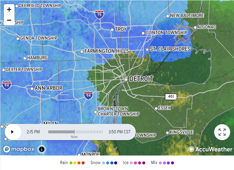
From a friend in troy, 10 miles west, it's heavy and sticking there.
Its heavy snow and sticking here at Metro, ground already coated too.
-
1
-
-
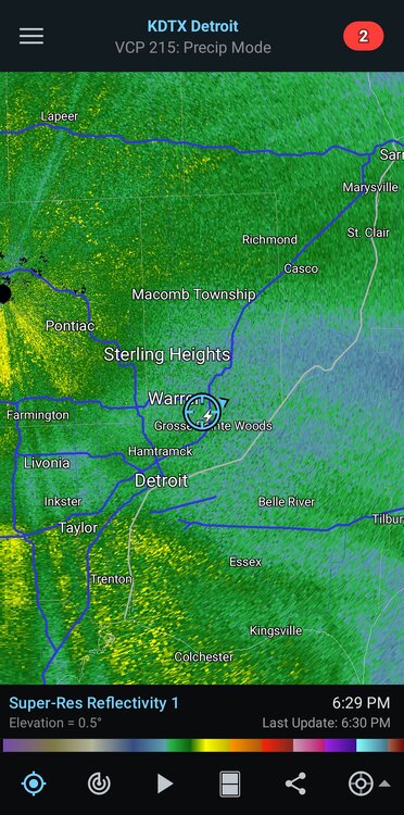
15 minutes ago, Powerball said:
lol...
Its not raining downtown, that map is wrong.
-
33/32 and heavy snow here at the airport.
-
1
-
-
Started as straight snow here at the airport about a half hour ago, it was 37/30 then now its 35/32. Still need a bit of work to get accumulations but it is all snow.
-
1 hour ago, Stevo6899 said:
I'm afraid sleet will mix in but about 50 miles west towards Pontiac into Oakland county may jackpot. Definitely the heaviest snow we get around here as far as rates go.
There won't be sleet, the warm air isn't aloft its at the surface for us. It will either be snow or rain.
-
1
-
-
Just now, roardog said:
The 12Z Nam does look slightly east again FWIW which may not be much but a few miles matter for us on the eastern side of the state, especially you guys down there.
Yeah, I will say this, the low that is supposed to come north is definitely on the east end of the guidance right now.
-
4 minutes ago, SolidIcewx said:
What would your analysis of our area be if I may ask?
An emoji of a man shrugging. Honestly its so changeable that I don't know what may happen. We need to keep the temp down though before precip falls otherwise we may be in the same situation as last event.
-
1
-
1
-
-
1 minute ago, King James said:
Not a Met but feels like warning criteria down in IKK. Don’t think wife will be able to get out of the driveway. Snow piling up over the wheel wells
That's quite a surprise considering that area was supposed to be right on the edge of things.
-
28 minutes ago, HillsdaleMIWeather said:
18Z Euro furthest west it's been all day
18Z GFS furthest east it's been all day
Gotta love the models
What do our met friends think?
Euro is going to score a big one or be big time wrong, most other models have leaned the other way today
-
23 minutes ago, Lightning said:
How does it look for Thundersnow potential over here??
Nonzero, especially if that powerband comes through for us.
-
2
-
1
-
-
3 minutes ago, Chicago Storm said:
Ya'll are slacking... No 18z GGEM mention?
Stack them deep
-
1 minute ago, mjwise said:
Middle 3rd of the country is pasted with wind advisories or high wind watches. I haven't seen so many issued for some time. Air travel is going to be rough at best the next few days even outside of places that get snow.
The big issue is if stuff from Chicago gets sent to Detroit and then Detroit overperforms. Jan 1999 blizzard happened like that.
-
3 hours ago, Possum said:
This feels like a dumb question but can anyone give me odds on a 9:30am flight on Saturday out of Midway happening? I’ve got some nephews in Dallas who are excited to see me, but the thought of trying to dig out that morning and make it from Humboldt Park to Midway just to sit around through delays and possibly cancellation instead of being cozy at home is stressing me out.
.Probably bad. Even if the weather is better by then the plane that was supposed to be there may not be.
-
4 hours ago, IWXwx said:
Oh, I don’t know, it may have been kind of fun having him around with this upcoming arctic dump.
Oh we can still make fun, he will read everything has he shrivels up like his palms.
-
1
-
3
-
-
1 minute ago, michsnowfreak said:
At the same time, it seems realistic to think that dynamic cooling will occur in the late afternoon/early evening with those rates.
Yeah but eventually warm air advection will win out.
-
1
-
-
2 minutes ago, SolidIcewx said:
Yeah early week did not turn out well at all. Would nighttime have a good effect on the cooling? Find it hard to believe that we will be pushing 40-42 at midnight 1am.
Advection will overpower nocturnal cooling. We will warm up, it just depends on which model as to how brief it will be.
-
2
-
-
Cromartie, since I know you are reading this, stop making accounts. You have made 7 accounts already that have been banned in the last week. Take a hint, you are banned, go find another place to annoy.
-
1
-
1
-
-
I honestly don't know what is going to happen here, but every model at this point but the Euro brings snow to SE MI as dynamic cooling takes effect as the low strengthens and has flow from the east or northeast. I am just a bit gun shy from the complete failure of Wednesday but the difference this time is the precip rates should be much more considerable, compared to the precip rates on Wednesday which were weak.
-
1
-
-
That being said I think SEMI gained a bit tonight on the models but its is incredibly tenuous and could easily go back the other direction. I would love to be in SW MI for this, they look to get absolutely bonecrushed.
-
3
-
-
1 minute ago, AWMT30 said:
Riding the RGEM here in SE MI thats for sure.
Its misleading a bit, it shows snow with a 3/2c surface. Unless it is absolutely coming down and cold aloft, that is rain. I will say it is decent up until 00z but its hard to buy
-
2
-

Jan 11-13th Blizzard
in Lakes/Ohio Valley
Posted
It filled in quite a bit, and when it does come in it might be as it gets colder.