

Stebo
-
Posts
33,272 -
Joined
-
Last visited
Content Type
Profiles
Blogs
Forums
American Weather
Media Demo
Store
Gallery
Posts posted by Stebo
-
-
4 minutes ago, RCNYILWX said:
Last year's ice storm in far northern Illinois has minimal if any road impacts and tremendous infrastructure impacts. That was our worst ice storm since I've been here, definitely worse impacts than 2/19/19. Honestly tough to say how the road impacts will play out tonight, especially if temps come up close to freezing with the aforementioned lighter winds.
Sent from my SM-G998U using Tapatalk
I'd have to imagine the roads will be bad considering how cold it was and for how long. Not quite to the magnitude of the ice storm after the Polar Vortex came south in 2014, but I do think it will be significant, especially with moderate precip rates vs heavy, limiting run off.
-
2 minutes ago, CheeselandSkies said:
Don't like that. Don't want to see more fires/smoke.
I have a feeling we will see a lot of last summer again maybe even worse.
-
 1
1
-
-
6 minutes ago, OrdIowPitMsp said:
Extended looks very dry in Minnesota. Top 10 driest January is closing in on a lock. Typical of a nino around here.
Yeah that area and places to your north and west are really in trouble with how dry it has been.
Alberta has really been suffering through a prolonged drought.
-
Yeah I think there is just too much focus on the power aspect when in reality the travel aspect is much more dangerous.
-
1 minute ago, King James said:
You’re the one keeping the palm guy discussion alive and a good deal of us find it entertaining lol
I am not the only one who wants him gone, far from it actually, and he keeps showing back up nearly every day with a new account and others engage mocking him. This is a tedious back and forth here though, so I'll just move along on this time waste.
-
2 minutes ago, RCNYILWX said:
Re. ISW discussion, while the officially listed criteria is still 0.25"+ of flat ice accretion, that's no longer the sole consideration. We have some research based guidance that places more emphasis on the importance of wind in attaining higher end impacts.
Wind results in more evaporative cooling, which translates to higher radial ice accretion that more strongly corresponds to true ice storm type impacts. Winds also bring down trees and powerlines. This case is less straightforward because of the lack of wind tonight. I can't speak to the decision process today yet, but if we don't upgrade, the lack of stronger wind will probably be a contributing factor.
I have heard this elsewhere as well about ISW vs WSW for places down south. While I agree with the accretion rate, I feel like with having been so cold the accretion on the roads will be pretty efficient and that's one variable that I don't think was considered as much down south initially.
-
1 minute ago, King James said:
Lol so angry
Okay, thanks for your empty contribution to the discussion
-
2 minutes ago, sbnwx85 said:
LOT and IWX current forecasts are definitely Ice Storm Warning criteria. As long as mode trends hold I expect they pull the trigger around Noon on areas forecast to get more than 1/4” of ice.
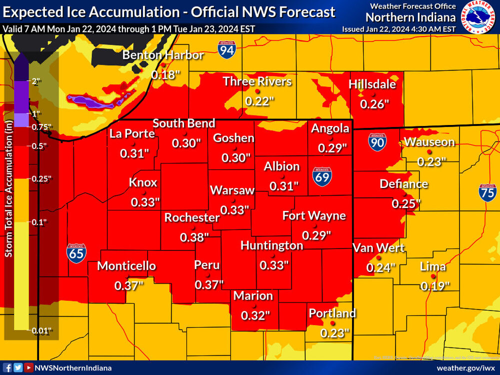
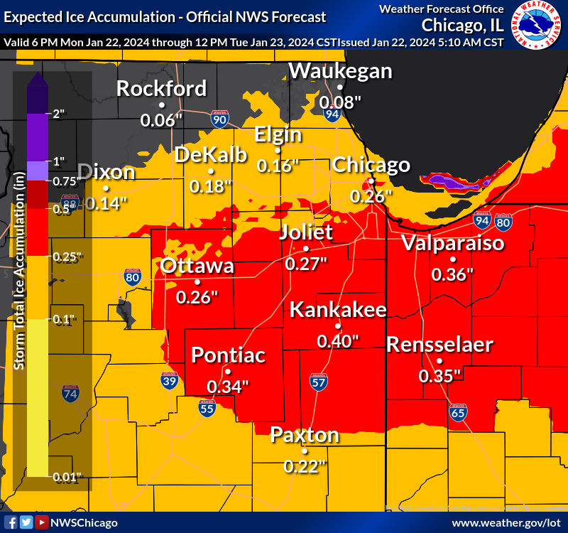
I feel like GRR/DTX are low balling this one too much. The only thing I could see that would lower the ice totals for along 94 for both would be a prolonged snow/sleet mixture before changing to ice.
-
 2
2
-
-
3 minutes ago, King James said:
Lol relax, this is a weather forum sir.
Yes it is, and we want to talk weather without an interrupting jerk who doesn't give a shit about anything other than interrupting this place. He has made 11 accounts already since being banned, he is the problem not those of us wanting him gone.
-
1
-
 2
2
-
-
He will be gone soon enough and will have to make his 11th account then. Cromartie just so you know none of us want you here too. Maybe take a hint and find a cesspool to go sink into, instead of trying to force your way back.
-
1
-
-
3 hours ago, Chicago Storm said:
bad take.
ORD finished slightly above normal in snowfall for Oct and Nov, and will now do the same for Jan.
obviously it has been a torch temp wise until the past week or so, but snowfall wise it is as expected.
I mean its a Nino too, what do people expect? At this point take the wins as you can get them.
-
2
-
1
-
-
6 minutes ago, OHweather said:
Same here with the lake stuff vs the synoptic. The synoptic at least produced a widespread accumulation but was largely hot garbage. QPF trended down the last couple of model runs and the ratios were more pedestrian. The lake enhanced stuff is high ratio and fairly intense.
Yeah we have had multiple bands push us down to 1/2SM here. Can't complain that's for sure.
-
Still getting some solid moderate snow here at DTW with the lake effect/enhancement off of Huron. Definitely an event saver for sure.
-
3 minutes ago, SolidIcewx said:
Got some nice rates right now. Down to about a 1/3 to 1/2 mile visibility. Love being outside in this

Just went to 1/2SM here at the airport, solid band with the lake effect.
-
20 hours ago, HillsdaleMIWeather said:
Models showing potential for some freezing rain Monday night into Tuesday morning
Since you mentioned this I wanted to give my thoughts on this one. There is definitely a moisture surge that comes north Monday into Tuesday, but it comes north with a modest LLJ, weaker than one would expect and the system isn't overly strong. What is good about that is the WAA would be weaker than expected, and with a cold dense air mass in place it would be slower to get shunted away and that's without factoring in a decent snow pack that gets added to today into tomorrow. I would say I could see a colder solution barring a dramatic change, and the GFS is definitely leaning that way with a solid snowfall on Tuesday with some ice along I-80.
-
1
-
-
As for the snow so far 1.4" as of 7am still snowing solidly as of this moment as well. Probably end up in the 2-3" range for the first part of the system.
-
10 hours ago, Chicago Storm said:
really dawg... little desperate now.
Don't worry he will be gone at some point today. Trying so hard to keep coming back as if any of us want him here.
-
45 minutes ago, Frog Town said:
Rookie error on my part. Was kind of hoping we could keep it going between the two, but that's wishful thinking.
There will be a bit of a lull but not that long, and clippers tend to move in quicker than forecast. Either way it looks like we will get some solid snows.
-
To be fair all of these maps include tonight but between tonight and thursday into friday it should be a solid hit of 4-8" across most of southern MI, Chicago should get some lake effect that would push them higher
-
1
-
1
-
-
50 minutes ago, A-L-E-K said:
NAM selling a weenie fgen band, gonna ride it
It's not alone either. Tomorrow night could be a surprise.
-
3 hours ago, A-L-E-K said:
only sickos enjoy this shit
Correct
-
Just now, mimillman said:
It’s the type of pattern that can surprise to the upside on high ratio events, which I like
The clipper tonight might. It's going to be high ratio for sure.
-
This was/is definitely a weird storm that is for sure.
-
3
-
-
13 minutes ago, RyanDe680 said:
GFS and Euro were pretty disappointing for this storm.
.GFS mostly did well here, it kept us mostly snow. Euro was not good.
-
1
-
Winter 2023/24 Medium/Long Range Discussion
in Lakes/Ohio Valley
Posted
Oh what levity