donsutherland1
-
Posts
24,362 -
Joined
Content Type
Profiles
Blogs
Forums
American Weather
Media Demo
Store
Gallery
Everything posted by donsutherland1
-
It did. The terrible attacks have left a scar that won’t ever fully heal.
-
From February 2001:

- 971 replies
-
- 10
-

-

-

-
Occasional Thoughts on Climate Change
donsutherland1 replied to donsutherland1's topic in Climate Change
Using @TheClimateChanger's inspirational mapping work using AI, I ran a map for Colorado. As noted on numerous occasions regarding Denver, summers have grown hotter with the frequency of 90° days increasing dramatically. Mean Number of 90° or Above Highs Each Year: 1872-1999: 27.6 days 2000-2025: 50.7 days 2000-2026: 51.2 days (64 days in 2026 through September 10; mean summer 2026 high: 90.4°) Is the rising heat largely confined to Denver or are summers warming across Colorado? Here's how Colorado's most recent 30-years (1997-2026) compare with the preceding 30-year period. The data show that some of the mountainous regions have seen more rapid summer warming than Denver. In sum, Denver's rising heat is part of a larger story of ongoing climate change.

-
Somewhat cooler air will overspread the region tonight. In the wake of the frontal passage, highs tomorrow and Friday will likely peak in the upper 70s. In general, the temperature should top out in the upper 70s and lower 80s from the weekend through the middle of next week. Some rain is possible Saturday night into early Sunday. The ENSO Region 1+2 anomaly was +4.6°C and the Region 3.4 anomaly was +2.7°C for the week centered around September 2. For the past six weeks, the ENSO Region 1+2 anomaly has averaged +4.12°C and the ENSO Region 3.4 anomaly has averaged +2.57°C. The ongoing strong El Niño, will continue to strengthen through the mid-fall. The Region 1+2 anomaly surpasses the all-time record of +4.5° that was set during the week centered around June 29, 1983. The SOI was -19.73 today. The preliminary Arctic Oscillation (AO) was +2.175 today. Based on sensitivity analysis applied to the latest guidance, there is an implied near 58% probability that New York City will have a warmer than normal September (1991-2020 normal). September will likely finish with a mean temperature near 70.0° (0.8° above normal). Supplemental Information: The projected mean would be 2.0° above the 1981-2010 normal monthly value.
-
Temperatures will likely peak in the lower and middle 80s tomorrow. A shower is possible tomorrow evening or tomorrow night. Another push of cooler air could arrive by Friday or Saturday. Highs on both days will likely peak in the upper 70s. The longer-term outlook has grown somewhat warmer through the middle of next week. In general, the temperature should top out in the upper 70s and lower 80s through the middle of next week. The ENSO Region 1+2 anomaly was +4.6°C and the Region 3.4 anomaly was +2.7°C for the week centered around September 2. For the past six weeks, the ENSO Region 1+2 anomaly has averaged +4.12°C and the ENSO Region 3.4 anomaly has averaged +2.57°C. The ongoing strong El Niño, will continue to strengthen through the mid-fall. The Region 1+2 anomaly surpasses the all-time record of +4.5° that was set during the week centered around June 29, 1983. The SOI was -15.92 today. The preliminary Arctic Oscillation (AO) was +2.211 today. Based on sensitivity analysis applied to the latest guidance, there is an implied near 63% probability that New York City will have a warmer than normal September (1991-2020 normal). September will likely finish with a mean temperature near 70.2° (1.0° above normal). Supplemental Information: The projected mean would be 2.2° above the 1981-2010 normal monthly value.
-
Occasional Thoughts on Climate Change
donsutherland1 replied to donsutherland1's topic in Climate Change
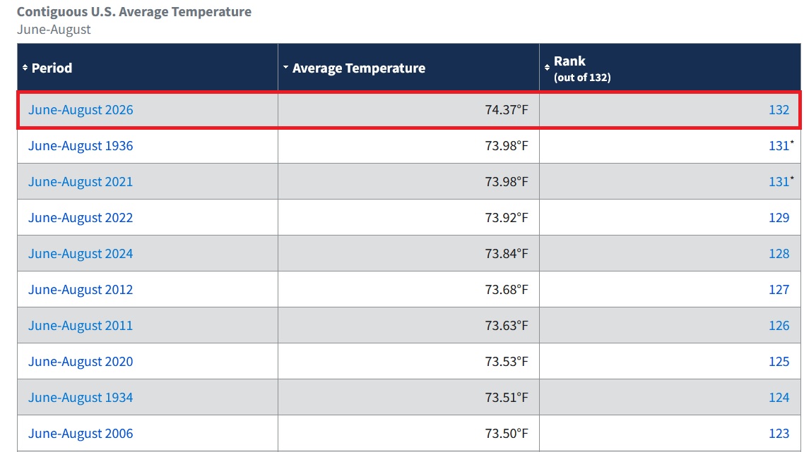
The preliminary data reveal that Summer 2026 swept past Summers 1936 and 2021 to easily become the warmest summer on record for the contiguous United States. Five of the ten warmest summers have occurred since 2020. Just two occurred during the 1930s.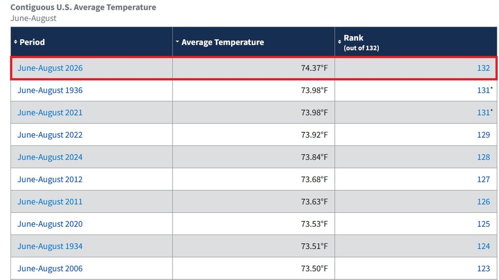
-
Occasional Thoughts on Climate Change
donsutherland1 replied to donsutherland1's topic in Climate Change
Astra did a really good job. -
Temperatures will likely peak in the lower and middle 80s tomorrow and Thursday. Another push of cooler air could arrive by Friday or Saturday. Overall, the week looks to be dry with little or no rainfall likely through at least Friday. the greatest likelihood for some showers is Thursday evening and Thursday night when a cold front crosses the region. The ENSO Region 1+2 anomaly was +4.6°C and the Region 3.4 anomaly was +2.7°C for the week centered around September 2. For the past six weeks, the ENSO Region 1+2 anomaly has averaged +4.12°C and the ENSO Region 3.4 anomaly has averaged +2.57°C. The ongoing strong El Niño, will continue to strengthen through the mid-fall. The SOI was -26.74 today. The preliminary Arctic Oscillation (AO) was +1.761 today. Based on sensitivity analysis applied to the latest guidance, there is an implied near 58% probability that New York City will have a warmer than normal September (1991-2020 normal). September will likely finish with a mean temperature near 69.9° (0.7° above normal). The Region 1+2 anomaly surpasses the all-time record of +4.5° that was set during the week centered around June 29, 1983. Supplemental Information: The projected mean would be 1.9° above the 1981-2010 normal monthly value.
-
Tomorrow will be a bit warmer with the high reaching the lower 80s. Temperatures will likely peak in the lower and middle 80s on Wednesday and Thursday. Another push of cooler air could arrive by Friday or Saturday. Overall, the week looks to be dry with little or no rainfall likely through at least Friday. The ENSO Region 1+2 anomaly was +4.6°C and the Region 3.4 anomaly was +2.7°C for the week centered around September 2. For the past six weeks, the ENSO Region 1+2 anomaly has averaged +4.12°C and the ENSO Region 3.4 anomaly has averaged +2.57°C. The ongoing strong El Niño, will continue to strengthen through the mid-fall. The SOI was -24.84 today. The preliminary Arctic Oscillation (AO) was +1.209 today. Based on sensitivity analysis applied to the latest guidance, there is an implied near 54% probability that New York City will have a warmer than normal September (1991-2020 normal). September will likely finish with a mean temperature near 69.7° (0.5° above normal). The Region 1+2 anomaly surpasses the all-time record of +4.5° that was set during the week centered around June 29, 1983. Supplemental Information: The projected mean would be 1.7° above the 1981-2010 normal monthly value.
-
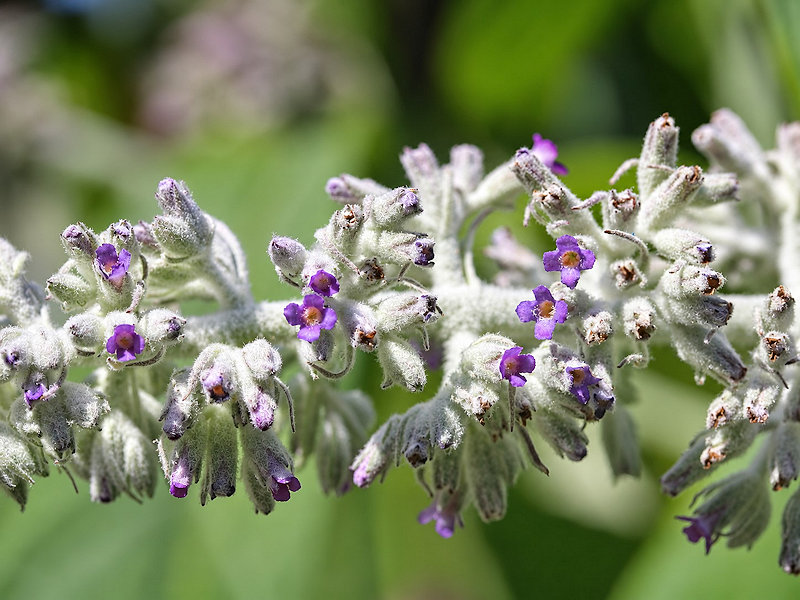
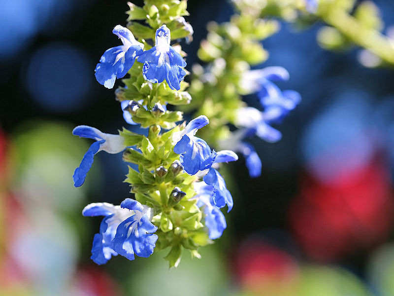
Five photos from the New York Botanical Garden on a sun-filled early September day. The hummingbird migration is in its early stages.



-
Yes. That's what the current 90-day figures show.
-
For reference, the latest first lows occurred as follows: 50s: September 17, 2016 40s: October 18, 2021 30s: November 13, 1946 and 2024
-
Occasional Thoughts on Climate Change
donsutherland1 replied to donsutherland1's topic in Climate Change
Thank you. Yes, that makes sense and it’s clear that there are many days where the mercury exceeds freezing. -
Occasional Thoughts on Climate Change
donsutherland1 replied to donsutherland1's topic in Climate Change
I may be referring to a different article. I was citing a ClimateBrink piece by Zeke Hausfather, which didn't mention bias correction. https://www.theclimatebrink.com/p/what-we-can-and-cannot-say-about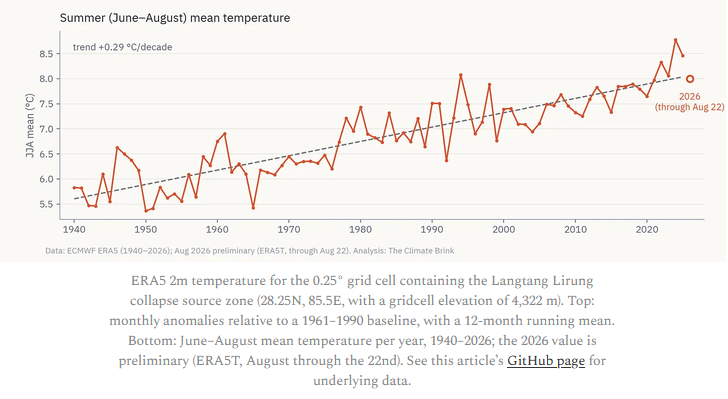
-
Tomorrow will be another day with somewhat cooler than normal temperatures, as the mercury tops out in the upper 70s. Tuesday will be a bit warmer with the high reaching the lower 80s. By midweek, readings could return to the lower 80s. A few of the warmer spots could top out in the middle 80s. Another push of cooler air could arrive by Friday or Saturday. Overall, the week looks to be dry with little or no rainfall likely through at least Friday. The ENSO Region 1+2 anomaly was +4.2°C and the Region 3.4 anomaly was +2.6°C for the week centered around August 26. For the past six weeks, the ENSO Region 1+2 anomaly has averaged +3.93°C and the ENSO Region 3.4 anomaly has averaged +2.50°C. The ongoing strong El Niño, which has reached super El Niño threshold, will continue to strengthen through the summer. The SOI was -21.33 today. The preliminary Arctic Oscillation (AO) was +0.838 today.
-
Occasional Thoughts on Climate Change
donsutherland1 replied to donsutherland1's topic in Climate Change
Here's where I think the issue lies. The graph is based on where the collapsing rock/glacier hit the valley (around 4,300 meters above sea level). The bedrock, glacier was about 5,200 meters. So, the graph is correct in that the region has been warming, but it is not the mean temperature of the actual glacier. Nevertheless, preceding the collapse, temperatures had reached 90° or above in Kathmandu. At standard lapse rates, that would suggest readings in the middle 40s at the altitude of the glacier. During the June 1-August 25 period, Kathmandu had 77 days with highs of 80° or above. At standard lapse rates, that would amount to highs of 35° or above at 5,200 meters. So, at least using the standard lapse rates and Kathmandu's data, most of the summer days saw at least some melting where the collapse took place. -
Occasional Thoughts on Climate Change
donsutherland1 replied to donsutherland1's topic in Climate Change
It is, but both sites are in different Himalayan subregions with different topography and wind exposure. -
Occasional Thoughts on Climate Change
donsutherland1 replied to donsutherland1's topic in Climate Change
The Everest base camp is about 160 km from the site of the bedrock/glacial collapse that occurred last month. -
Occasional Thoughts on Climate Change
donsutherland1 replied to donsutherland1's topic in Climate Change
Florac, France, where September records go back to 1861, has recorded its three hottest September temperatures on record during the current heatwave. September 4, 1966 saw its first 30C (86F) or above September temperature on record.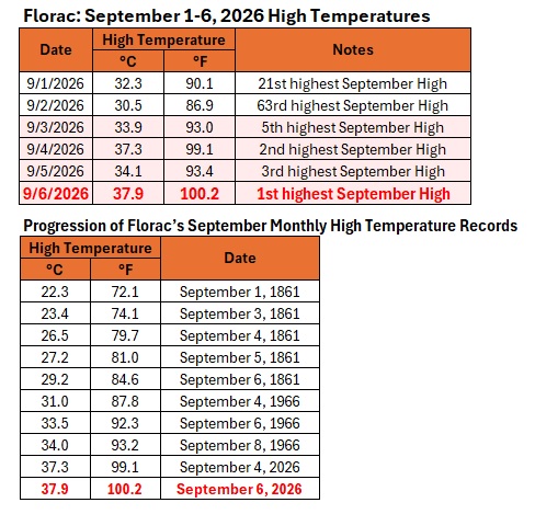
-
A cool Labor Day weekend has commenced. Temperatures will generally peak in the middle and upper 70s. Readings in New York City could fall into the lower 60s with widespread 50s outside the City. The cool weather will likely continue into the middle of next week. By midweek, readings could return to the lower 80s. Another push of cooler air could arrive by Friday or Saturday. The ENSO Region 1+2 anomaly was +4.2°C and the Region 3.4 anomaly was +2.6°C for the week centered around August 26. For the past six weeks, the ENSO Region 1+2 anomaly has averaged +3.93°C and the ENSO Region 3.4 anomaly has averaged +2.50°C. The ongoing strong El Niño, which has reached super El Niño threshold, will continue to strengthen through the summer. The SOI was -16.70 today. The preliminary Arctic Oscillation (AO) was +0.627 today.
-
A few areas could see an evening shower. Most of the region will remain dry. Cooler air will move in overnight. A cooler air mass will cover the region for the Labor Day weekend. In its wake, temperatures will generally peak in the middle and upper 70s. Readings in New York City could fall into the lower 60s with widespread 50s outside the City. The cool weather will likely continue through at least the middle of next week. The ENSO Region 1+2 anomaly was +4.2°C and the Region 3.4 anomaly was +2.6°C for the week centered around August 26. For the past six weeks, the ENSO Region 1+2 anomaly has averaged +3.93°C and the ENSO Region 3.4 anomaly has averaged +2.50°C. The ongoing strong El Niño, which has reached super El Niño threshold, will continue to strengthen through the summer. The SOI was -7.78 today. The preliminary Arctic Oscillation (AO) was +0.293 today.
-
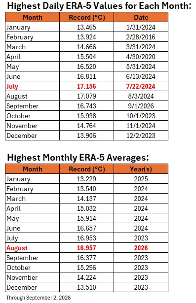
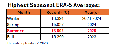
Highest daily values for each month and highest monthly and seasonal averages on ERA-5:
-
In advance, have a very happy birthday.
-
Occasional Thoughts on Climate Change
donsutherland1 replied to donsutherland1's topic in Climate Change
Here’s a reasonable substitute: https://www.pyreweather.org I hope the shortsighted decision to stop updating the PSL site will be reversed in the future. -
Occasional Thoughts on Climate Change
donsutherland1 replied to donsutherland1's topic in Climate Change
The idea that the bedrock collapsed leading to the glacial collapse and subsequent debris flow has gained increasing support. However, one can't automatically suggest that because the bedrock collapsed, climate change wasn't involved. The literature links a warming climate to destabilization of high mountain terrain. One recent study noted: The study found that rising temperatures are destabilizing high mountain terrain in India’s Kinnaur district and creating conditions that could trigger chains of disasters, including avalanches or landslides that spill into glacier lakes and produce destructive flooding downstream. A quick assessment by University of Colorado researchers also linked climate change observing: Satellite and drone images suggest that softening permafrost, or perennially frozen rock, ice and soil, on Langtang Lirung peak likely caused a massive bedrock failure and glacier collapse. An estimated 50 million metric tons of ice, rock and water—roughly 13 billion gallons, or about three times the capacity of Boulder Reservoir—fell 6,500 feet into the valley below, unleashing a slurry of mud and water that inundated bridges, hydropower facilities and villages along the way. According to the United States Geological Survey, the force of the initial debris flow hitting the ground was equivalent to a magnitude 5.2 earthquake... Since the 1850s, changes in high-altitude permafrost have contributed to dozens of these cascading disasters in Nepal and parts of India, in which bedrock and glaciers break off, and trigger massive flash floods and debris flows. For example, in 2012 a slurry flood in central Nepal, similar to what happened in Nepal last week, killed 79 people along the Seti River. The University of Reading also provided the following account: Researchers from the HiRisk project, which investigates cryosphere-related hazards in High Mountain Asia, suggest that longer-term glacier retreat and permafrost degradation may have contributed to slope destabilisation. The failed glacier retreated by approximately 450m between 1990 and 2020, potentially reducing the mechanical support provided by the glacier to the underlying rock slope. Permafrost degradation may have further contributed to instability. The warmer than average temperatures observed in the area this summer might have contributed to the glacier collapse too, although observations at these elevations remain limited. As a side note, this assessment also refers to "warmer than average temperatures" during the summer. That's something the maps I posted showed in contradiction to JB's cropped map. Based on the evidence and literature: 1) A climate link is highly likely, but the magnitude of the contribution from climate change is uncertain. 2) The absence of a climate link is probably close to zero Considering the literature and emerging assessments, the burden of proof rests with those such as Martz to support the argument that climate change played no role. Arguing that climate change played no role (Martz's proposition) is quite different from suggesting that the extent of contribution by climate change remains to be determined. As noted previously, there had been record heat in the region for several days prior to the catastrophe. Moreover, frost-wedging can lead to the fracturing of rocks over long periods of time, and in the warming climate of the altitude Himalayas, this form of weathering has increased in frequency.