donsutherland1
-
Posts
23,768 -
Joined
Content Type
Profiles
Blogs
Forums
American Weather
Media Demo
Store
Gallery
Everything posted by donsutherland1
-
Expectations need to be anchored in probabilistic thinking. Otherwise, the expectations are unrealistic. Discussion of patterns e.g., with outcomes 40% above climatology do not mean that the outcomes are anything close to certain. Major or historic events are uncommon. Otherwise, they wouldn't be major, much less historic events. The coefficients of determination among variables is modest. A lot of other variables explain outcomes. Some factors are not well-understood e.g., a lot of work remains to be done on ocean-atmosphere interactions for specific events. Some variables may not even be known. Simplifications are representations. There are limits imposed by realities of the coefficients of determination. Dynamic changes created by a growing greenhouse effect also add complexity. Some events are inherently more complex than others. Phasing events are highly complex and difficult to forecast at medium-term or extended ranges. Occasionally, a model will have a good extended range outlook for a given event, but that's the exception not the rule. Forecasts related to the 1993 superstorm were an exception. Even with continuing advances in modeling, such outcomes cannot be replicated on anything approximating a consistent basis. Moreover, there is no "super model" that is decisively better than the others. Finally, 7-10-day discussions are about possibilities and should be understood as such. Operational guidance at that range is relatively low but not zero skill. Ensembles provide insight into plausible scenarios. Inside 5 days, confidence in outcomes can increase, but considerable uncertainty still exists. One cannot "lock in" solutions at such time scales when it comes to details, even as confidence in general ideas rises.
-
Morning thoughts… It will become partly cloudy. High temperatures will reach the lower and middle 40s in most of the region. Likely high temperatures around the region include: New York City (Central Park): 43° Newark: 45° Philadelphia: 44° Tomorrow will be another dry day. Normals: New York City: 30-Year: 43.8°; 15-Year: 44.6° Newark: 30-Year: 44.3°; 15-Year: 45.2° Philadelphia: 30-Year: 45.5°; 15-Year: 46.7°
-
The storm responsible for rain along the coast and some snow well inland will wind down tonight. So far, precipitation totals are in line with expectations. Amounts included: Albany: 1.76" (today's 1.60" set a daily record) Binghamton: 0.93" (7.3" of snow) Boston: 0.87" Bridgeport: 1.03" New York City: 1.28" Newark: 1.17" Philadelphia: 2.05" (yesterday's 1.90" set a daily record) Providence: 1.17" In the wake of the departing storm, a cold but dry weekend will follow. Late next week could see another storm bring precipitation to the region. Model solutions range from accumulating snow in the New York City-Newark area to a potential Ohio Valley/Great Lakes blizzard. Details remain to be sorted out, but the latter scenario is currently the favored one on the ensembles. Once that storm passes, the season's coldest air so far will pour into the region. The latest EPS weeklies continue to suggest that near normal to below normal temperatures could prevail during the December 19-26 and December 27-January 2 periods. No severe cold is likely through at least the first three weeks of December. Afterward, as the PNA goes neutral, the prospect for snowfall and more significant cold could increase. The AO fell reached -4.000 on December 10th. Since 1950, there were 11 cases that saw the AO reach -4.000 or below during December. Mean snowfall for those cases was 9.0" (Median: 9.1"). 64% of such cases saw 6" or more of snowfall in December while 45% of such cases saw 10.0" or more snow. In contrast, during all other December cases, mean December snowfall was 3.5" (Median: 2.5"). 91% of those cases also saw a colder than normal December in the northern Middle Atlantic region. In terms of seasonal snowfall, 64% of those seasons saw 30" or more snowfall in New York City with 45% having 40" or more. Just 18% of such cases had less than 20" seasonal snowfall, both of which had less than 10" for the December-January period. The ENSO Region 1+2 anomaly was -0.7°C and the Region 3.4 anomaly was -1.0°C for the week centered around December 7. For the past six weeks, the ENSO Region 1+2 anomaly has averaged -1.23°C and the ENSO Region 3.4 anomaly has averaged -0.95°C. La Niña conditions will likely persist through mid-winter. The SOI was +11.83 today. The preliminary Arctic Oscillation (AO) was -2.548 today. On December 14 the MJO was in Phase 4 at an amplitude of 0.652 (RMM). The December 13-adjusted amplitude was 0.751 (RMM). Based on sensitivity analysis applied to the latest guidance, there is an implied 75% probability that New York City will have a colder than normal December (1991-2020 normal). December will likely finish with a mean temperature near 37.7° (1.4° below normal).
-
Radical differences lead to radically different outcomes.
-
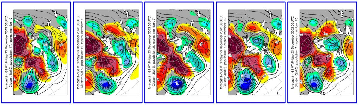
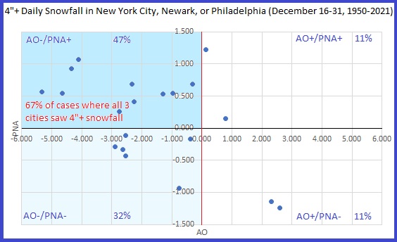
At present, neither mourning nor celebration is in order for the potential December 23-24 storm. The picture will be getting clearer after the coming weekend. Phasing events are complex and details matter greatly. At extended ranges, even the best models don't fully resolve the details. With the PNA forecast to be rising to neutral or somewhat positive levels coupled with a strongly negative AO, the region has its highest probability relative to climatology for at least an appreciable snowfall. Nearly half of all December 16-31 days with 4" or more snowfall in either New York City, Newark, or Philadelphia during 1950-2021 have occurred with an AO-/PNA+ pattern (and two thirds of storms with daily snowfall of 4" or more in all three cities). There are no guarantees, of course. Some similar patterns deliver very little (December 1950). Others deliver large amounts of snow (December 2010 into January 2011). The majority of 12/16 0z EPS individual ensemble members have measurable snowfall and a small cluster (around 15%) have 10" or more snowfall in the region. Cluster analysis supports the idea of multiple scenarios being on the table. The 12z guidance will provide additional insight. A good starting point for a potential event that is still 144-192 hours away is probably the 12/16 15z run of the National Blend of Models (NBM). The , which currently shows about 2.5" of snow in New York City, Newark, and Philadelphia.
-
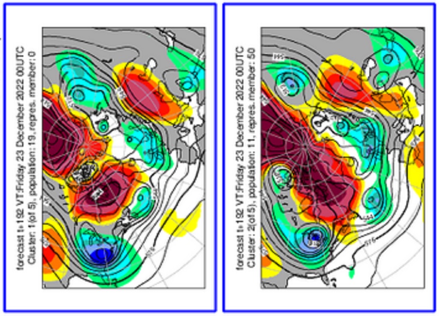
The 12/16/2022 0z EPS 500 mb clusters. Still plenty of opportunity for a snowy solution. Whether the number of scenarios gives hope to the hopeless or hopelessness to the hopeful remains to be seen.
-
Morning thoughts… Today will be rainy and windy. Winds could gust past 40 mph at times. High temperatures will reach the middle and perhaps upper 40s in most of the region. Likely high temperatures around the region include: New York City (Central Park): 46° Newark: 47° Philadelphia: 47° Dry weather will return tomorrow and a quiet weekend is in store. Normals: New York City: 30-Year: 44.1°; 15-Year: 44.8° Newark: 30-Year: 44.6°; 15-Year: 45.5° Philadelphia: 30-Year: 45.8°; 15-Year: 47.0°
-
Congratulations.
-
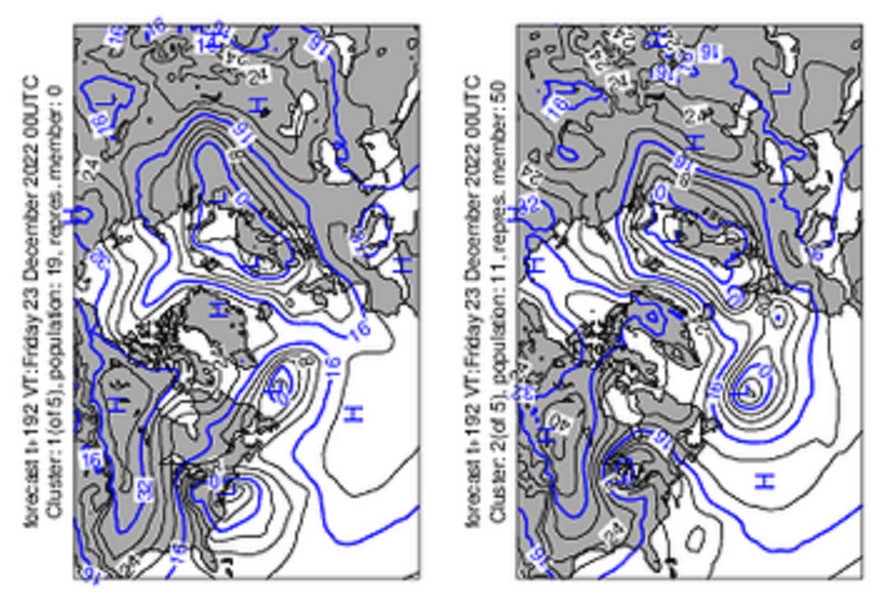
The 12/15/2022 12z EPS clusters:
-
A complex storm will continue to bring a cold rain to coastal regions tomorrow. Some of the rain could be heavy. A general 0.50"-1.50" with locally higher amounts is likely. Interior sections could see some additional accumulating snow. An area of moderate to significant snowfall is likely across central Pennsylvania to central New York State. The latest EPS weeklies continue to suggest that near normal to below normal temperatures could prevail during the December 19-26 and December 27-January 2 periods. No severe cold is likely through at least the first three weeks of December. Afterward, as the PNA goes neutral, the prospect for snowfall and more significant cold could increase. Already, the guidance is showing an increased change of snow for the December 22-24 timeframe. The AO fell reached -4.000 on December 10th. Since 1950, there were 11 cases that saw the AO reach -4.000 or below during December. Mean snowfall for those cases was 9.0" (Median: 9.1"). 64% of such cases saw 6" or more of snowfall in December while 45% of such cases saw 10.0" or more snow. In contrast, during all other December cases, mean December snowfall was 3.5" (Median: 2.5"). 91% of those cases also saw a colder than normal December in the northern Middle Atlantic region. In terms of seasonal snowfall, 64% of those seasons saw 30" or more snowfall in New York City with 45% having 40" or more. Just 18% of such cases had less than 20" seasonal snowfall, both of which had less than 10" for the December-January period. The ENSO Region 1+2 anomaly was -0.7°C and the Region 3.4 anomaly was -1.0°C for the week centered around December 7. For the past six weeks, the ENSO Region 1+2 anomaly has averaged -1.23°C and the ENSO Region 3.4 anomaly has averaged -0.95°C. La Niña conditions will likely persist through mid-winter. The SOI was +4.15 today. The preliminary Arctic Oscillation (AO) was -3.216 today. December 1-15 has experienced the strongest AO block on record for the first half of December. The AO averaged a preliminary -2.908 (old record: -2.138, 1985) with 8 days at or below -3.000 (old record: 6 days, 1966). On December 13 the MJO was in Phase 4 at an amplitude of 0.743 (RMM). The December 12-adjusted amplitude was 1.070 (RMM). Based on sensitivity analysis applied to the latest guidance, there is an implied 71% probability that New York City will have a colder than normal December (1991-2020 normal). December will likely finish with a mean temperature near 37.9° (1.2° below normal).
-
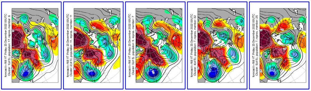
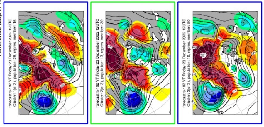
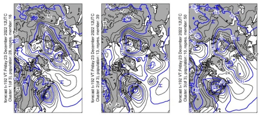
I use them all the time. There's also a 1000 mb cluster scenario. Here's what the two largest clusters look like for 12/23 (the first with 19 members has a Miller B-type scenario and probably comprises all 9 of the individual members showing 10" or more snow in the NYC-EWR areas; the second large group is very unfavorable for the coastal plain). I flipped the charts so it is easier to view North America.
-
Morning thoughts… Clouds will increase and a soaking rain will arrive. Snow changing to rain will overspread interior sections. High temperatures will reach the lower and perhaps middle 40s in most of the region. Likely high temperatures around the region include: New York City (Central Park): 42° Newark: 44° Philadelphia: 47° The rain will continue tomorrow. Some interior sections could see additional snowfall. Normals: New York City: 30-Year: 44.3°; 15-Year: 45.1° Newark: 30-Year: 44.8°; 15-Year: 45.7° Philadelphia: 30-Year: 46.0°; 15-Year: 47.0°
-
12/15 - 12/16 Coastal/Winter Storm & Observations
donsutherland1 replied to Northof78's topic in New York City Metro
Tomorrow, a complex storm will bring a cold rain to coastal regions into Friday. Some of the rain could be heavy. A general 0.50"-1.50" is likely. Interior sections could see accumulating snow before a changeover. The potential exists for a moderate to perhaps significant snowfall from central Pennsylvania across central New York State. The latest EPS weeklies continue to suggest that near normal to below normal temperatures could prevail during the December 19-26 and December 27-January 2 periods. No severe cold is likely through at least the first three weeks of December. Afterward, as the PNA goes neutral, the prospect for snowfall and more significant cold could increase. Reflecting the rising probability of snowfall, about 50% of the 12z EPS ensemble members currently show 1" or more snowfall for New York City during the December 23-24 period. The AO fell reached -4.000 on December 10th. Since 1950, there were 11 cases that saw the AO reach -4.000 or below during December. Mean snowfall for those cases was 9.0" (Median: 9.1"). 64% of such cases saw 6" or more of snowfall in December while 45% of such cases saw 10.0" or more snow. In contrast, during all other December cases, mean December snowfall was 3.5" (Median: 2.5"). 91% of those cases also saw a colder than normal December in the northern Middle Atlantic region. In terms of seasonal snowfall, 64% of those seasons saw 30" or more snowfall in New York City with 45% having 40" or more. Just 18% of such cases had less than 20" seasonal snowfall, both of which had less than 10" for the December-January period. The ENSO Region 1+2 anomaly was -0.7°C and the Region 3.4 anomaly was -1.0°C for the week centered around December 7. For the past six weeks, the ENSO Region 1+2 anomaly has averaged -1.23°C and the ENSO Region 3.4 anomaly has averaged -0.95°C. La Niña conditions will likely persist through mid-winter. The SOI was +1.61 today. The preliminary Arctic Oscillation (AO) was -3.136 today. On December 12 the MJO was in Phase 4 at an amplitude of 1.066 (RMM). The December 11-adjusted amplitude was 1.307 (RMM). Based on sensitivity analysis applied to the latest guidance, there is an implied 62% probability that New York City will have a colder than normal December (1991-2020 normal). December will likely finish with a mean temperature near 38.3° (0.8° below normal). -
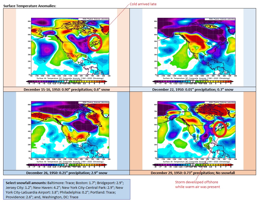
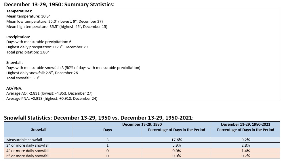
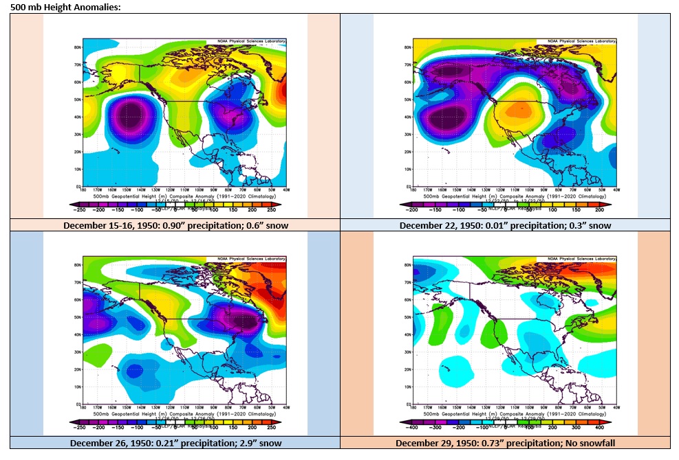
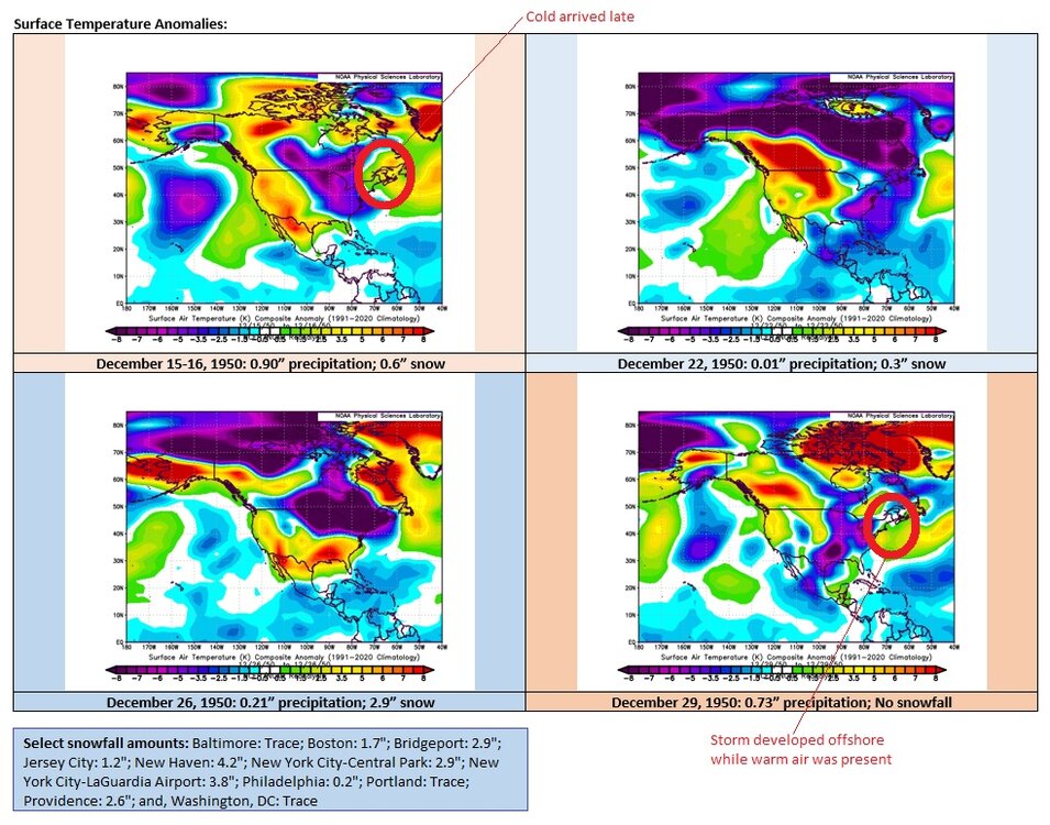
The Block that "Disappointed" During December 13-29, 1950, a period of exceptionally strong Atlantic blocking coincided with a positive PNA. Although the number of measurable snowfall events wound up above historic climatology for the period, there were no major snowstorms in the Philadelphia to New York City area. There was a light to moderate event on December 26 as Arctic air poured into the region. There was a "near miss" on December 29, as a storm developed offshore but readings were too warm for snowfall. On January 7, 1951, Boston picked up 7.6" of snow. This period of strong blocking occurred during a La Niña. It offers a reminder that even patterns that are often associated with heavy snowfall can wind up with less snowy outcomes. The outcome of what lies ahead for December 2022 remains to be determined. This short analysis is not a prediction of any kind of how the current blocking episode will unfold as the PNA moves toward neutral and then positive levels during the closing 7-10 days of the month. Although, the December 15-16 storm won't deliver snowfall to the Philadelphia to Boston region, another storm could bring precipitation during the December 23-24 period. Below are some statistics from New York City and charts from the December 13-29, 1950 blocking episode.
-
Morning thoughts… Today will be mostly sunny but cold. High temperatures will reach the upper 30s and lower 40s in most of the region. Likely high temperatures around the region include: New York City (Central Park): 40° Newark: 42° Philadelphia: 42° A soaking rain will develop tomorrow in the coastal plain. Interior sections will likely see snow changing to rain. Normals: New York City: 30-Year: 44.6°; 15-Year: 45.3° Newark: 30-Year: 45.1°; 15-Year: 46.0° Philadelphia: 30-Year: 46.3°; 15-Year: 47.2°
-
Tonight will be another fair and cold night. By Thursday, a complex storm could bring a cold rain or snow changing to rain to coastal regions into Friday. Interior sections could see accumulating snow before any changeover. The potential exists for a moderate to perhaps significant snowfall from central Pennsylvania across central New York State. The latest EPS weeklies continue to suggest that near normal to below normal temperatures could prevail during the December 19-26 and December 27-January 2 periods. No severe cold is likely through at least the first three weeks of December. Afterward, as the PNA goes neutral, the prospect for snowfall and more significant cold could increase. The AO fell reached -4.000 on December 10th. Since 1950, there were 11 cases that saw the AO reach -4.000 or below during December. Mean snowfall for those cases was 9.0" (Median: 9.1"). 64% of such cases saw 6" or more of snowfall in December while 45% of such cases saw 10.0" or more snow. In contrast, during all other December cases, mean December snowfall was 3.5" (Median: 2.5"). 91% of those cases also saw a colder than normal December in the northern Middle Atlantic region. In terms of seasonal snowfall, 64% of those seasons saw 30" or more snowfall in New York City with 45% having 40" or more. Just 18% of such cases had less than 20" seasonal snowfall, both of which had less than 10" for the December-January period. The ENSO Region 1+2 anomaly was -0.7°C and the Region 3.4 anomaly was -1.0°C for the week centered around December 7. For the past six weeks, the ENSO Region 1+2 anomaly has averaged -1.23°C and the ENSO Region 3.4 anomaly has averaged -0.95°C. La Niña conditions will likely persist through mid-winter. The SOI was -0.58 today. The preliminary Arctic Oscillation (AO) was -3.854 today. On December 11 the MJO was in Phase 4 at an amplitude of 1.306 (RMM). The December 10-adjusted amplitude was 1.394 (RMM). Based on sensitivity analysis applied to the latest guidance, there is an implied 58% probability that New York City will have a colder than normal December (1991-2020 normal). December will likely finish with a mean temperature near 38.5° (0.6° below normal).
-
You can currently access it at chat.openai.com
-
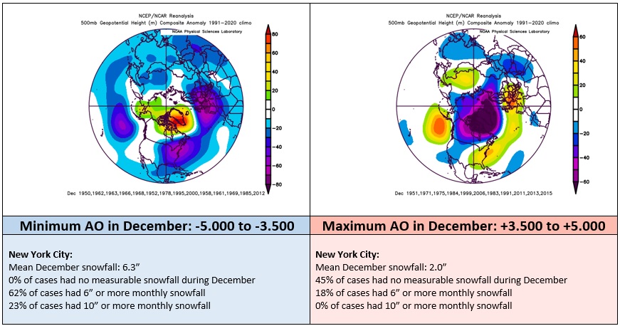
The probability of snowfall (measurable and significant) is notably higher than climatology during strong blocking patterns, especially when the PNA is positive at this time of year (and all of January). Higher probabilities are not guarantees. While the extreme blocking during 2010-2011 led to a big December blizzard and very snowy 30 days albeit after a long wait from late November, there have been cases where strong blocking did not produce such an outcome. Winter 1958-1959 is one such example. That the AO is forecast to remain negative through much or all of the remainder of December and the PNA will slowly move to somewhat positive levels in the closing 7-10 days of December--a slow move illustrated by the statistical guidance--suggests at least a window of opportunity with increased potential. Certainly, the forecast pattern is much better than a warm EPO+/AO+ pattern that all but assures little or no meaningful prospects for snowfall. It is also noted that the EPS weeklies that came out yesterday continued to show colder than normal weather during December 19-26. They also flipped to a colder outcome for the following week, as well. The CFSv2 has now moved into general agreement with the EPS weeklies, after having shown unbroken warmth in the East through December. Finally, since ChatGPT, an AI language model has garnered significant press coverage in recent days, I asked it to construct a poem that captures the sentiments of some of us who are eagerly awaiting or hoping for a big snowfall. Here's what it produced: The snowstorm is coming, they say It's just a matter of time But as the days go by And the skies remain clear and blue I can't help but wonder If this storm will ever arrive I wait and watch As the world goes on around me People bustling, living their lives But I am stuck in this state of anticipation Hoping for the snow to fall I long to see the world blanketed in white To hear the gentle crunch of snow underfoot To feel the cold embrace of winter But it seems that it will never come And so I wait Patiently, restlessly Hoping that one day The storm will arrive And I can finally experience The joy of a big snowfall.
-
Morning thoughts… Today will be mostly sunny but cold. High temperatures will reach the upper 30s and lower 40s in most of the region. Likely high temperatures around the region include: New York City (Central Park): 39° Newark: 41° Philadelphia: 42° The cool but dry weather will continue through midweek. Normals: New York City: 30-Year: 44.9°; 15-Year: 45.6° Newark: 30-Year: 45.4°; 15-Year: 46.2° Philadelphia: 30-Year: 46.6°; 15-Year: 47.5°
-
Tonight will be fair and cold. By Thursday, a complex storm could bring a cold rain or snow changing to rain to coastal regions into Friday. Interior sections could see accumulating snow before any changeover. The potential exists for a significant snowfall from central Pennsylvania across central New York State. The latest EPS weeklies continue to suggest that near normal to below normal temperatures could prevail during the December 19-26 and December 27-January 2 periods. No severe cold is likely through at least the first three weeks of December. Afterward, as the PNA goes neutral, the prospect for snowfall and more significant cold could increase. The AO fell reached -4.000 on December 10th. Since 1950, there were 11 cases that saw the AO reach -4.000 or below during December. Mean snowfall for those cases was 9.0" (Median: 9.1"). 64% of such cases saw 6" or more of snowfall in December while 45% of such cases saw 10.0" or more snow. In contrast, during all other December cases, mean December snowfall was 3.5" (Median: 2.5"). 91% of those cases also saw a colder than normal December in the northern Middle Atlantic region. In terms of seasonal snowfall, 64% of those seasons saw 30" or more snowfall in New York City with 45% having 40" or more. Just 18% of such cases had less than 20" seasonal snowfall, both of which had less than 10" for the December-January period. The ENSO Region 1+2 anomaly was -0.7°C and the Region 3.4 anomaly was -1.0°C for the week centered around December 7. For the past six weeks, the ENSO Region 1+2 anomaly has averaged -1.23°C and the ENSO Region 3.4 anomaly has averaged -0.95°C. La Niña conditions will likely persist through mid-winter. The SOI was -7.11 today. The preliminary Arctic Oscillation (AO) was -3.854 today. On December 10 the MJO was in Phase 4 at an amplitude of 1.390 (RMM). The December 9-adjusted amplitude was 1.513 (RMM). Based on sensitivity analysis applied to the latest guidance, there is an implied 55% probability that New York City will have a colder than normal December (1991-2020 normal). December will likely finish with a mean temperature near 38.7° (0.4° below normal).
-
Yes. February 2010. On February 6, the AO fell to -5.205. Afterward, it rose to -4.266 on February 10. On February 14, it bottomed out again at -5.132.
-
227 NOUS41 KOKX 121321 PNSOKX CTZ005>012-NJZ002-004-006-103>108-NYZ067>075-078>081-176>179-130121- Public Information Statement National Weather Service New York NY 821 AM EST Mon Dec 12 2022 ...SNOWFALL REPORTS... Location Amount Time/Date Provider ...Connecticut... ...Fairfield County... 4 NNW New Fairfield 3.3 in 0430 AM 12/12 Trained Spotter Shelton 2.4 in 0755 PM 12/11 Cocorahs 3 E New Fairfield 2.2 in 0855 PM 12/11 Public Bethel 2.0 in 0700 PM 12/11 Public Ridgefield 1.5 in 0500 PM 12/11 Amateur Radio Bridgeport Airport 0.8 in 0700 AM 12/12 Official NWS Obs Norwalk 0.5 in 0720 PM 12/11 Broadcast Media ...Middlesex County... Clinton 1.7 in 0220 AM 12/12 Broadcast Media Westbrook 1.6 in 1140 PM 12/11 Trained Spotter ...New Haven County... Hamden 3.6 in 0700 AM 12/12 Trained Spotter 1 E North Haven 3.0 in 1115 PM 12/11 Trained Spotter North Haven 2.5 in 0730 PM 12/11 Trained Spotter Seymour 2.0 in 0751 PM 12/11 Trained Spotter Guilford 1.8 in 0800 PM 12/11 Trained Spotter 1 SW Branford 1.6 in 0700 AM 12/12 Trained Spotter ...New London County... Groton 2.3 in 0600 AM 12/12 Trained Spotter ...New Jersey... ...Bergen County... 2 NNE Franklin Lakes 2.8 in 1245 AM 12/12 Trained Spotter 1 WSW Washington Township 0.5 in 0600 PM 12/11 Trained Spotter Mahwah 0.3 in 0315 PM 12/11 Trained Spotter ...Essex County... North Caldwell 0.5 in 0540 PM 12/11 Trained Spotter ...Hudson County... Harrison 0.2 in 0230 AM 12/12 CO-OP Observer ...Passaic County... Wayne 0.7 in 0530 PM 12/11 Public ...Union County... Newark Airport 0.1 in 0700 AM 12/12 Official NWS Obs ...New York... ...Bronx County... 1 NW Fordham 0.9 in 0600 AM 12/12 Public ...Nassau County... Manhasset Hills 0.3 in 0800 AM 12/12 Public ...New York County... Central Park T in 0700 AM 12/12 Official NWS Obs ...Orange County... Walden 4.4 in 0940 PM 12/11 Public 2 WNW Monroe 4.0 in 1130 AM 12/11 Trained Spotter 2 SSW Stewart Airport 4.0 in 0155 AM 12/12 Public Monroe 3.5 in 0520 AM 12/12 Trained Spotter 3 NNE Unionville 3.2 in 0936 PM 12/11 Public Newburgh 3.0 in 0830 PM 12/11 Public 1 WNW Monroe 3.0 in 0920 PM 12/11 Trained Spotter Middletown 2.0 in 0400 PM 12/11 Trained Spotter Walden 1.9 in 0400 PM 12/11 CO-OP Observer ...Queens County... NYC/La Guardia 0.4 in 0700 AM 12/12 Official NWS Obs NYC/JFK T in 0700 AM 12/12 Official NWS Obs ...Rockland County... Chestnut Ridge 2.1 in 1245 AM 12/12 Public ...Suffolk County... North Babylon 0.4 in 0645 AM 12/12 Public Islip Airport 0.4 in 0700 AM 12/12 Official NWS Obs West Islip 0.3 in 0350 AM 12/12 Trained Spotter Upton 0.3 in 0700 AM 12/12 Official NWS Obs ...Westchester County... 1 SW White Plains Airport 2.0 in 1030 PM 12/11 Trained Spotter 1 NW New Rochelle 1.1 in 0700 AM 12/12 Public Mamaroneck 0.5 in 0920 PM 12/11 Trained Spotter &&
-
LaGuardia: 0.4" Newark: 0.1" Central Park and JFK: Trace
-
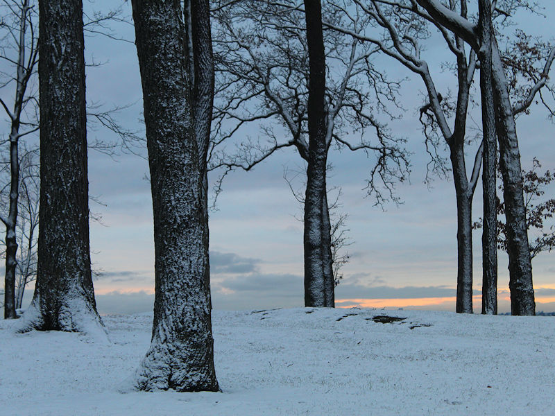
The morning after the snowfall:
-
Morning thoughts… Clouds will give way to partly sunny skies. It will be cool. High temperatures will reach the upper 30s and lower 40s in most of the region. Likely high temperatures around the region include: New York City (Central Park): 40° Newark: 42° Philadelphia: 44° The cool but dry weather will continue through midweek. Normals: New York City: 30-Year: 45.2°; 15-Year: 45.8° Newark: 30-Year: 45.7°; 15-Year: 46.5° Philadelphia: 30-Year: 46.9°; 15-Year: 47.7°