donsutherland1
-
Posts
23,761 -
Joined
Content Type
Profiles
Blogs
Forums
American Weather
Media Demo
Store
Gallery
Everything posted by donsutherland1
-
Extreme Cold, Snow & Sleet: SECS 1/24 - 1/26
donsutherland1 replied to TriPol's topic in New York City Metro
Yes. Lake effect snow has very high ratios, because the air mass moving across the lakes is often both frigid. -
Extreme Cold, Snow & Sleet: SECS 1/24 - 1/26
donsutherland1 replied to TriPol's topic in New York City Metro
In general, higher QPF events have lower ratios. Warmer air holds more moisture. Warmer air can result in less favorable snow growth in the atmosphere, riming, etc. -
Extreme Cold, Snow & Sleet: SECS 1/24 - 1/26
donsutherland1 replied to TriPol's topic in New York City Metro
I believe both the December 26-27, and January 1st events were clippers. -
Extreme Cold, Snow & Sleet: SECS 1/24 - 1/26
donsutherland1 replied to TriPol's topic in New York City Metro
It's my understanding that the data should be captured in tonight's 0z model cycle. -
Extreme Cold, Snow & Sleet: SECS 1/24 - 1/26
donsutherland1 replied to TriPol's topic in New York City Metro
Both were clippers, if I recall correctly. 2004 event: 30-19 2005 event: 26-9 -
Extreme Cold, Snow & Sleet: SECS 1/24 - 1/26
donsutherland1 replied to TriPol's topic in New York City Metro
For reference: Since 2000, there have been only two days with 4" or more snow and a 20:1 or above snow-liquid ratio in New York City: January 28, 2004 4.3" snow/0.18" precipitation (the snow-liquid ratio for the entire January 27-28, 2004 storm was just below 16:1 with 10.3" snow and 0.65" precipitation) January 23, 2005 5.3" snow/0.25" precipitation -
Extreme Cold, Snow & Sleet: SECS 1/24 - 1/26
donsutherland1 replied to TriPol's topic in New York City Metro
Neither Cobb05 nor Cobb11 on Bufkit show ratios of 20:1. At the height of the storm, the 1/22 0z NBM shows approximately 15:1 ratios. They later fall below 10:1. -
Extreme Cold, Snow & Sleet: SECS 1/24 - 1/26
donsutherland1 replied to TriPol's topic in New York City Metro
Two maps while we wait for the 0z cycle to kick off: Threat of Heavy Snow: Probability of a Major Winter Storm Impact: It should be noted that within the next day or two, model skill in handling synoptic details will improve markedly over the current lead time. That process could accelerate somewhat with tonight's reconnaissance flight.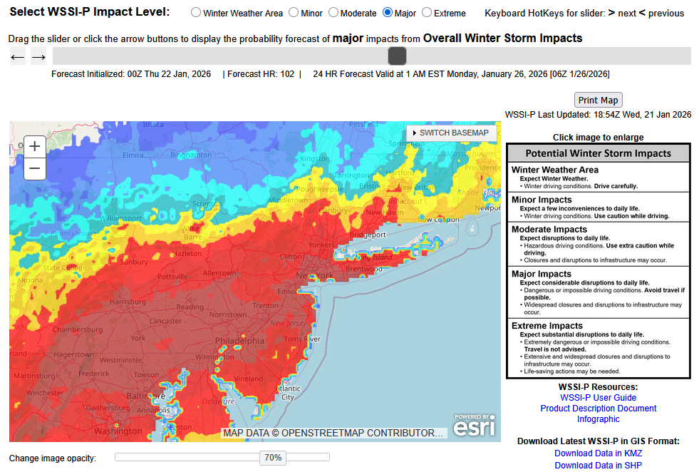
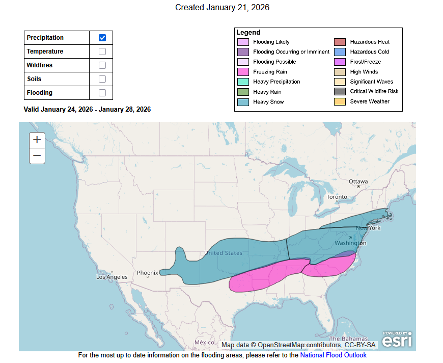
-
Extreme Cold, Snow & Sleet: SECS 1/24 - 1/26
donsutherland1 replied to TriPol's topic in New York City Metro
The last time New York City saw a 6" or greater snowfall was January 28-29, 2022 when 8.3" fell. Its last 10" or above snowfall occurred during January 31-February 3, 2021 when 17.4" accumulated. -
Extreme Cold, Snow & Sleet: SECS 1/24 - 1/26
donsutherland1 replied to TriPol's topic in New York City Metro
The March 2001 nightmare. Some members probably have no recollection. Others might not have been born yet. AREA FORECAST DISCUSSION NATIONAL WEATHER SERVICE NEW YORK NY 242 AM EST SAT MAR 3 2001 WL GO AHD AND ISSUE WSW FOR ENTIRE FA FOR 3D PD. AVN/ECMWF CONSISTANT AND SHOWG MAJOR LO PRES EFFECTG FA SUN AFTN THRU AT LEAST TUE MRNG. THINKG IN XS OF A FT OF SNW...ALNG WITH 25 TO 30 MPH WNDS...IE NR BLIZZARD LIKE CONDITIONS...SUN NGT THRU TUE MRNG. THIS HAS THE POTENTIAL TO BE THE STRNGST STM SINCE THE JAN 96 BLIZZARD. THE ETA AND NGM HAVE COME OVR TO THE AVN/ECMWF SOLN AS WELL AS THE NOGAPS. THE CANADIAN AND UKMET STILL SHOWG A MORE PROGRESSIVE SYSTEM. BUT IF THE SYSTEM GOES VERTICAL...AS IT SEEMS IT WL NOW...IT WL STALL BTWN DELMARVA AND CAPE COD...AND CUD HAMMER US THRU TUE MRNG. AM CONFIDENT ENUF THAT WE WILL GET SOMETHING THUS WL GO AHD AND PULL THE TRIGGR ON THE WSW. ON THE MARINE...THINKG WE CUD GET CSTL FLOODG PROBLMS AT TIMES OF HI TIDE...BEGNG SUN NGT. THATS STILL 4TH PD...AND WL NOT ISSUE A CSTL FLD WATCH ATTM. BUT ONE WL PROBLY BE ISSUED THIS AFTNS PCKG. WRKZFP IN AWIPS BY 3.5 AM. ZNS WIBIS BTW 4 AND 4.5 AM. ON THE MARINE...WL CONTINUE MENTION OF GLS SUN NGT ON. PROBLY BE UP TO SCA SUN AFTN. AREA FORECAST DISCUSSION NATIONAL WEATHER SERVICE NEW YORK NY 230 PM EST SAT MAR 3 2001 DISC: SNOW DEVLPNG DURING SUN AFTN AND WL GET HVY FROM SUN NIGHT THRU MON AND BEYOND. WL ISSUE A CSTL FLD WATCH WITH THIS PACKAGE. WILL HOLD OFF AN GO WITH THE WINTER STORM WATCH FOR NOW. EVE/MID CREW WILL HAVE TO UP TO A WARNING. ONLY PROBLEM WITH FCST IS...WL OUR ERN L.I. ZONES MIX WITH SOME SLEET AT TIMES. FOR NOW DID MENTION THE THE MIX COMING IN DURING SUNDAY NIGHT. AREA FORECAST DISCUSSION NATIONAL WEATHER SERVICE NEW YORK NY 220 AM EST SUN MAR 4 2001 CURRENT MDLS PUSHG A BIT WRMR BDLRY AIR INTO FA ON MON. EVEN SO DOES NOT CHG MY THINKG ON PTYPE. IT WL BE SNW...WET SNW...PERHAPS MIXG WITH A BIT OF SLEET DURG THE DAY MON. LO MOVES OFF DELMARVA MON MRNG...IT GOES AS FAR N AS ITS GOING TO BTW 00Z-06Z TUE. THN RETROGRADES SWD TUE MRNG. THEN BEGINS MOVG EWD TUE AFTN. THINKG SNW TAPERS OFF TO SHSN BEFORE ENDG LATE MRNG/ERLY AFTN TUE. THINKG IT WL BE A WET SNW...PEHAPS A 5 TO 1 RATIO CSTS AND 1 TO 8 INLND. EVEN SO WITH 2 PLUS INCHES OF LIQ EQV...TRANSLATES TO 10 TO 18 IN. PLACES INLND WL SEE 2 PLUS FT OF SNW. THINKG THAT ANY WARMG WL BE OFFSET BY EVAP COOLG. AREA FORECAST DISCUSSION NATIONAL WEATHER SERVICE NEW YORK NY 940 AM EST SUN MAR 4 2001 CURRENT MDLS PUSHG A BIT WRMR BDLRY AIR INTO FA ON MON. EVEN SO DOES NOT CHG MY THINKG ON PTYPE. IT WL BE WET SNW...BCMG SLEET MON NGT IN STG ERLY WND. LO MOVES OFF DELMARVA MON MRNG...IT GOES AS FAR N AS ITS GOING TO BTW 00Z-06Z TUE. THN RETROGRADES SWD TUE MRNG. THEN BEGINS MOVG EWD TUE AFTN. THINKG SNW TAPERS OFF TO SHSN BEFORE ENDG LATE MRNG/ERLY AFTN TUE. PREV FCST LOOKS GOOD INCLUDING TOTAL SNWFALL SO LITTLE IF ANY CHGS FORESEEN AT THIS TIME. BIG QUESTION REMAINS ON JUST HOW MILD COASTAL LOCATIONS WILL BECOME AND THUS HOW MUCH SNOWFALL AMTS WILL BE HELD DOWN. AREA FORECAST DISCUSSION NATIONAL WEATHER SERVICE NEW YORK NY 300 AM EST MON MAR 5 2001 PRETTY GOOD AGREEMENT THIS MDL RUN BTN ETA AND AVN...BOTH ALF AND AT SFC. SFC LO CNTR NR THE VA CST TO MOV SLOLY NE TDY AND TNGT...GETTING ABREAST OF THE FCST AREA AFT MIDN...THEN RETROGRADING AND ESSENTIALLY DOING A LOOP TO THE SW TUE BFR HEADING OUT TO SEA TUE NGT AND WED. PCPN HAS BEEN SLO TO GET GOING AS THE LO BCMS MORE ORGANIZED. SOME WRMR AIR WORKING IN ALF HAS RESULTED IN SLEET AND FRZG RAIN MXG IN WITH THE LGT SNW THUS FAR...SPCLY NR THE CST. HWVR AS THE LO CNTR MOVS FTHR OFF THE CST THIS MRNG THEN TURNS NE THIS AFTN...DRAWING COLDER AIR BCK IN...THE MXD PCPN WL CHG TO SNW THRUOUT THE RGN. AT THIS POINT WL STICK WITH THE CURRENT FCST OF 8 TO 14 INCHES OF SNW NR THE CST AND 1 TO 2 FT INLD. HWVR WITH THE LO CNTR DVLPG A BIT TOO FAR N...AND EVENTUALLY RMNG NR OUR AREA FOR A GOOD PART OF THE EVENT...AM THINKING THAT IF A CHG NEEDS TO BE MADE AS THE DAY PROGRESSES IT WOULD BE TO REDUCE THE TOTALS A BIT...SPCLY NR THE CST...UNLESS WE PICK UP A LOT OF SNW ON THE BCKSIDE. BUT WITH THE UNCERTAINTIES IN THE LENGTH OF TIME IT WL SNW...WL NOT TAMPER WITH THE AMTS NOW. AREA FORECAST DISCUSSION NATIONAL WEATHER SERVICE NEW YORK NY 1005 AM EST MON MAR 5 2001 WILL UPDATE ZONES ASAP. LARGE WARM LAYER AS SEEN ON MORNING SOUNDING. TEMPS AT OR ABOVE FREEZING RIGHT NEAR THE COAST...SO AM LOOKING AT RAIN FOR A PART OF THIS AFTERNOON. SLEET EVEN BEING REPORTED WELL INLAND. WILL LOWER OR DROP ANY SNOWFALL ACCUM FOR THIS AFTERNOON. DO HAVE A CONCERN ON NEW FORECAST PATH OF SURFACE LOW...BUT MORE ON THAT LATER. AM CONCERNED ABOUT SIGNIFICANT QPFS REMAINING JUST TO OUR NORTH ON WRAP AROUND AND IN BANDS AS LOW MOVES VERY CLOSE. AREA FORECAST DISCUSSION NATIONAL WEATHER SERVICE NEW YORK NY 235 PM EST MON MAR 5 2001 WESTERN SECTIONS (INCLUDING NYC) STARTING TO CHANGE OVER TO SNOW AS UPPER LOW APPROACHES. HEAVIEST PRECIP NOW OVER EASTERN ZONES. MODELS SIMILAR WITH POSITIONING OF LOW THROUGH TONIGHT...THEN SOME DIFFERENCES TUESDAY. THE BOTTOM LINE IS THAT ETA BRINGS THE MAJORITY OF THE QPF TO THE NORTH OF THE LOW...WHICH CORRESPONDS TO JUST NORTH OF OUR CWA. THE SFC LOW MOVES VERY CLOSE TO LI...WHICH RESULTS IN TOO MUCH DRY AIR ALOFT IN THE MID AND UPPER LAYERS FOR ANY HEAVIER QPF AMOUNTS. I LIKE THE AVN LOOK BETTER AS WRAP AROUND AND PLENTY OF UVM OCCURS FROM NE TO SW FROM ROUGHLY BOS VCNTY INTO SOUTHERN CT. THIS OCCURS THROUGH THE DAY TUESDAY...THEN CATEGORICAL SNOW CONTINUES TUESDAY NIGHT BUT LIGHTENS UP AS UPPER SUPPORT AND SFC LOW PULLS FINALLY TO THE EAST. IN THE SHORT TERM...18Z SOUNDING SHOWS TOO MUCH WARM AIR AROUND H8 TO OVERCOME...EVEN WITH HEAVY PRECIP APPROACHING. DYNAMIC COOLING WILL NOT OVERCOME THIS WARM LAYER FOR LATE THIS AFTERNOON ACROSS EASTERN SECTIONS. FURTHER WEST...ANY MIXTURE SHOULD CHANGE TO ALL SNOW QUICKLY BEFORE 00Z. EAST ZONES WILL TAKE A LITTLE LONGER. AREA FORECAST DISCUSSION NATIONAL WEATHER SERVICE NEW YORK NY 735 PM EST MON MAR 5 2001 SHORT TERM DISC: AREAL COVERAGE AND INTENSITY OF PRECIPITATION HAS INCREASED SIGNIFICANTLY ACROSS CT AND LONG ISLAND. THE LTST LOOP OF RADAR IMAGES SHOWED ROTATION EMBEDDED WITHIN THE PRECIP FIELD ABOUT 40 MILES SOUTH OF LONG ISLAND/S SOUTHERN FORK. WIDESPREAD MODERATE SNOW WITH BANDS OF HEAVY SNOW CONTINUE TO WRAP-AROUND THE INTENSE OFFSHORE LOW. SNOW CONTS TO FALL AT THE RATE OF ARND 1 INCH PER HOUR. THE LTST OKX SOUNDING SHOWS TEMPS BELOW FREEZING THROUGHOUT. AREA FORECAST DISCUSSION NATIONAL WEATHER SERVICE NEW YORK NY 200 AM EST TUE MAR 6 2001 SHORT RANGE DISC: WIDESPREAD LIGHT SNOW...WITH EMBEDDED BANDS OF MODERATE SNOW CONT TO WRAP-ARND A 981 MB LOW NEAR BOUY 44008 AT 05Z. AT 06Z...9.1 INCHES OF SNOW HAS BEEN MEASURED AT OKX. IN GENERAL... SNOWFALL SHOULD GRADUALLY DECREASE THRU AT LEAST 09Z AS A MID AND UPPER LVL DRY SLOT CONTS TO WRAP WESTWARD ACRS CT. MEDIUM RANGE DISC: AS STATED IN NCEP/S MODEL DIAGNOSTIC DISC...THE ETA AND NGM MDLS HAVE TRENDED FURTHER EAST...CLOSER TO THE AVN SOLN...FOR LOOPING THE LOW BACK TWD THE SOUTHWEST. THE ETA AND NGM TRACK THE LOW BACK TWD 71W LONGITUDE WHILE THE AVN TRACKS THE LOW ALONG 69W LONGITUDE. IN EITHER CASE...STG GRADIENT WINDS WILL CONT AS NW WINDS BACK TWD THE NORTH. AS FAR AS PRECIP AND OUR QPF...LARGE SCALE LIFT WILL ONCE AGAIN INCREASE AS THE STG UPPER LVL LOW APPROACHES THE REGION. THE GREATEST LIFT OCCURS FM 12Z TO 21Z...WHEN WIDESPREAD LGT SNOW WITH EMBEDDED BANDS OF MODERATE SNOW WILL AFFECT THE REGION. I BELIEVE THE HEAVIEST SNOW...WILL OCCUR ACRS CT AND LONG ISLAND...CLOSER TO THE LOW/S PATH...WHERE AN ADDITIONAL 3 TO 6 INCHES COULD FALL. FURTHER WEST...AN ADDITIONAL 2 TO 4 INCHES IS LIKELY. AREA FORECAST DISCUSSION NATIONAL WEATHER SERVICE NEW YORK NY 330 AM EST WED MAR 7 2001 DISC: AS OF EARLY ON THE SHIFT THERE STILL WERE SOME BANDS OF LIGHT SNOW FALLING THROUGH THE FA. THIS WAS IN RESPONSE TO THE DEEP STACKED LOW PRESS WHICH WAS DRIFTING VERY SLOWLY TO THE SW. THE SFC AND H5 LOWS WERE IN THE SAME POSITION AND LOOKING AT THE IR LOOP STREAMS OF PCPN WERE ROTATING AROUND THE LOW. THEY SHD END BEFORE FCST IS PUBLISHED AND WILL NOT MENTION ANYTHING IN THE ZONES. -
Tomorrow will be the warmest day of the week with highs reaching or surpassing 40°. However, the mild temperatures will be shortlived. An even colder Arctic front will cross the region on Thursday, possibly with some snow flurries or snow showers. A frigid weekend lies ahead. Snow could arrive on Sunday. A significant snowfall is possible in and around the New York City area and surrounding region, even if a transition to sleet could occur at some point during the storm. The last time New York City saw a 6" or greater snowfall was January 28-29, 2022 when 8.3" fell. Its last 10" or above snowfall occurred during January 31-February 3, 2021 when 17.4" accumulated. There remains uncertainty and it may still be another day or two before the details can be pinned down with high confidence. The temperature will likely stay below 20° in New York City and much of the region on Saturday. The last time that happened in New York City was January 21, 2025 when the high was 19°. Overall, January 20th-February 3rd will likely be the coldest and perhaps snowiest two-week period this winter. The forecast WPO-/EPO-/AO-/PNA+ pattern is typically the coldest pattern in January and among the coldest during the first half of February. A persistently positive PNA will have above climatological risk of moderate or significant snowfalls. For perspective, the coldest two-week period this winter prior to January 20th was January 3-16, 2026 and January 4-17, 2026 with a mean temperature of 30.3°. The snowiest two-week period was December 14-27, 2025 when 7.2" of snow fell. The ENSO Region 1+2 anomaly was -0.3°C and the Region 3.4 anomaly was -0.7°C for the week centered around January 14. For the past six weeks, the ENSO Region 1+2 anomaly has averaged -0.48°C and the ENSO Region 3.4 anomaly has averaged -0.68°C. La Niña conditions will likely continue into at least late winter. The SOI was +7.54 today. The preliminary Arctic Oscillation (AO) was -2.334 today. Based on sensitivity analysis applied to the latest guidance, there is an implied near 98% probability that New York City will have a cooler than normal January (1991-2020 normal). January will likely finish with a mean temperature near 30.7° (3.0° below normal). Supplemental Information: The projected mean would be 1.9° below the 1981-2010 normal monthly value.
-
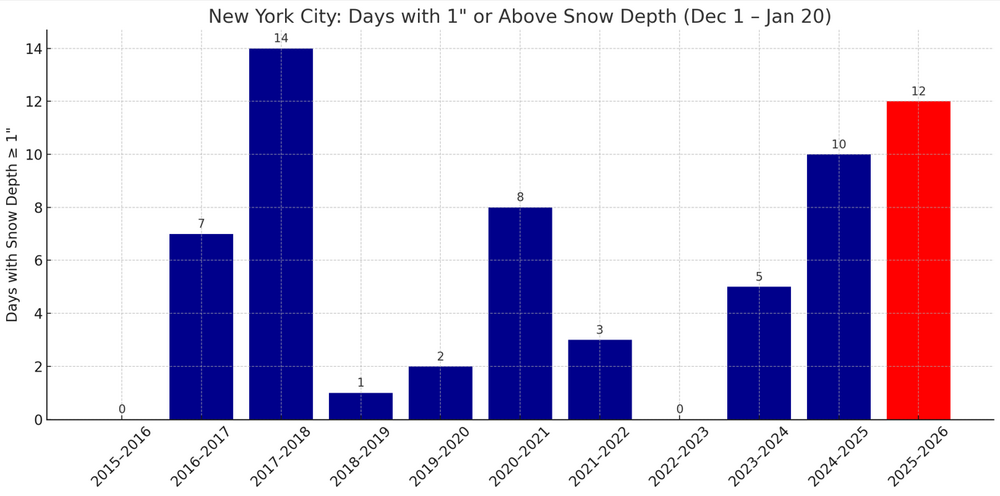
For those tracking snow cover, New York City has had the most days with 1" or above snow cover since Winter 2017-2018 through January 20th.
-
Extreme Cold, Snow & Sleet: SECS 1/24 - 1/26
donsutherland1 replied to TriPol's topic in New York City Metro
Overall, it appeared that the 12z ECMWF was a bit flatter than the 0z ECMWF, hence the slight reduction in QPF. Overall, the consensus of the guidance continues to point toward a significant snowfall, even with the risk of some sleet getting involved late in the storm. -
Extreme Cold, Snow & Sleet: SECS 1/24 - 1/26
donsutherland1 replied to TriPol's topic in New York City Metro
Do you have a link to these maps? -
Occasional Thoughts on Climate Change
donsutherland1 replied to donsutherland1's topic in Climate Change
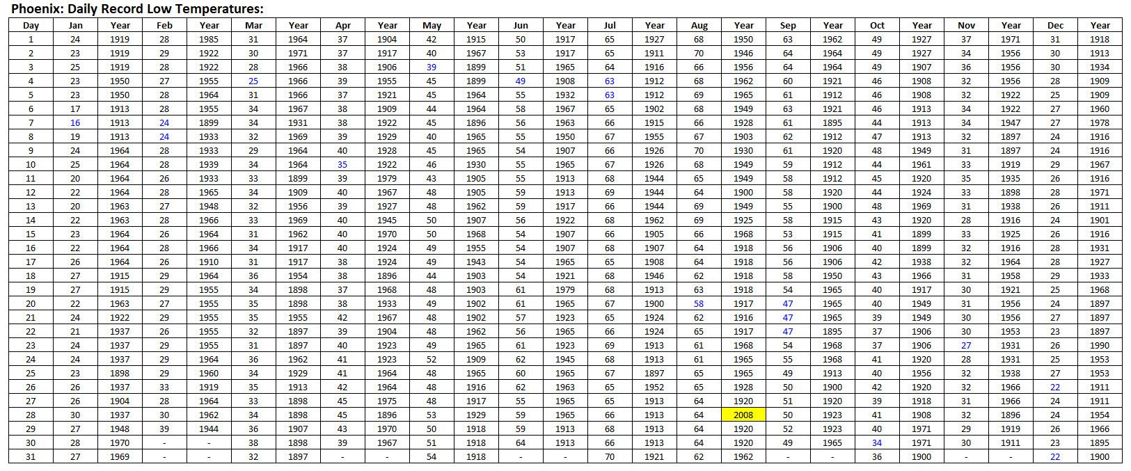
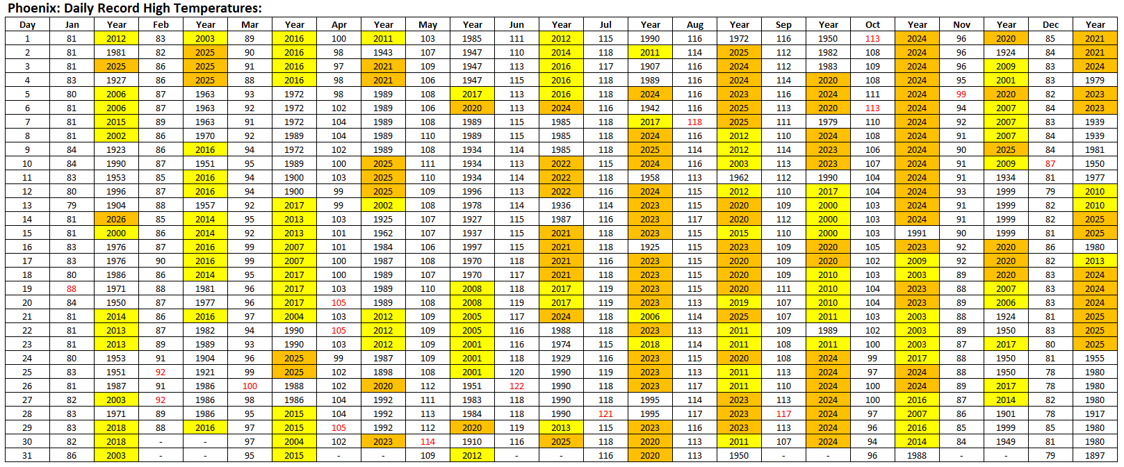
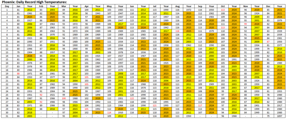
Record high (minimum and maximum temperatures) are being tied or broken more frequently than record low (minimum and maximum) temperatures. In rapidly warming places, the outcomes are especially skewed. UHI + climate change are driving the outcome in the cities. Here's Phoenix. Yellow denotes 2000-2019; Orange denotes 2000-2026.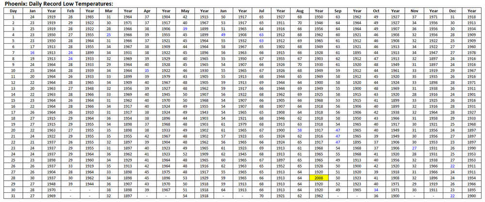
-
Yes. The potential is there. It does seem that the Weathermodels' charts overdo the lows e.g., it showed 6° for today. I'm not sure if the algorithm can't handle the UHI effect in NYC. It seems that the charts assume greater radiational cooling than is possible in NYC. Outside the city e.g., White Plains, they typically do better.
-
Extreme Cold, Snow & Sleet: SECS 1/24 - 1/26
donsutherland1 replied to TriPol's topic in New York City Metro
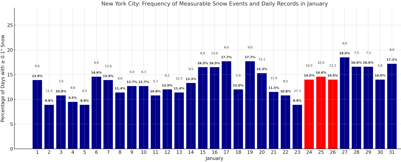
For reference, the frequency of measurable snow events and the highest daily snowfall. The January 24-26 period is highlighted in red to reflect the coming storm.
-
Extreme Cold, Snow & Sleet: SECS 1/24 - 1/26
donsutherland1 replied to TriPol's topic in New York City Metro
It seems that the classic meteorological movie where Arctic high pressure and strong confluence were initially expected to crush a snowstorm to the South only to see the storm come northward due to better phasing and reduced confluence is poised to play again. Much of the guidance has now moved into closer agreement over a significant snowfall in the New York City area Sunday into Monday. Some of the guidance even introduces sleet in a 2026 remake of the PD2 snowstorm of February 2003 where a storm arrived during bitter cold, and then sleet fell for a time a day later. The NBM QPF forecasts for New York City reveal the movie's snowy plot. 1/20 0z: 0.25" 1/20 12z: 0.48" 1/21 0z: 0.62" 1/21 11z: 0.97" While we enjoy the popcorn in eager anticipation of the 12z cycle and even greater anticipation of the region's biggest snowstorm in several years, discarded definitive claims from social media about what the storm won't do or can't do lie on the floor waiting to be swept away by the unfolding events. -
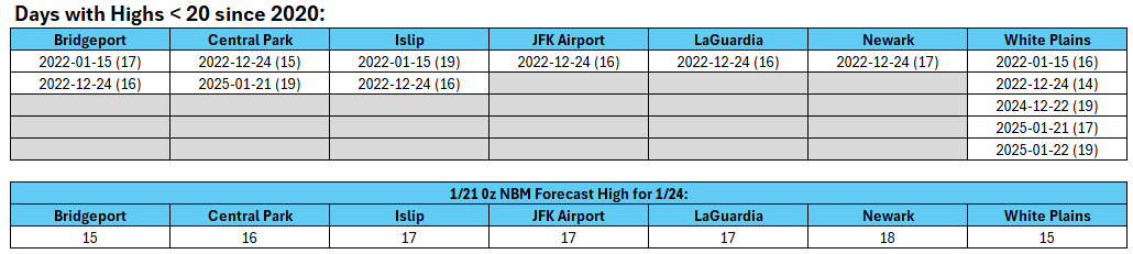
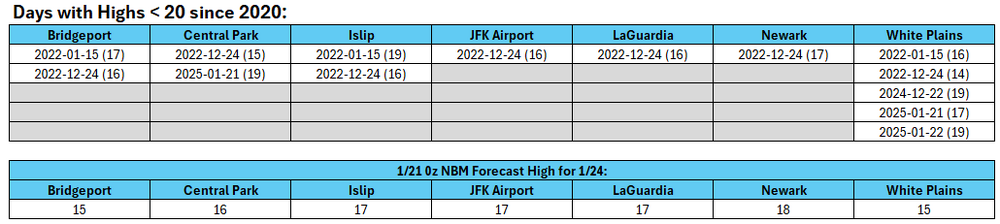
Saturday and possibly Sunday could see high temperatures below 20° across much of the New York City area. Such frigid highs have been very infrequent since 2020.
-
Winter cancelled/uncancelled banter 25/26
donsutherland1 replied to Rjay's topic in New York City Metro
From my sister in Maine: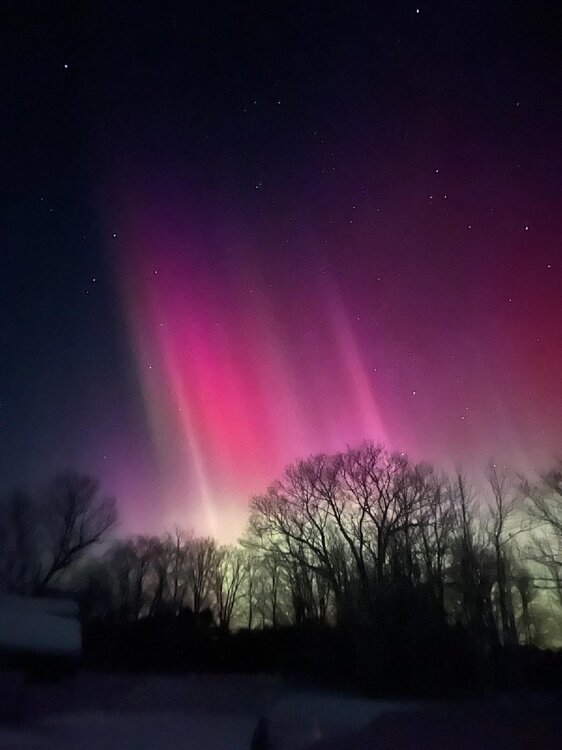
-
Extreme Cold, Snow & Sleet: SECS 1/24 - 1/26
donsutherland1 replied to TriPol's topic in New York City Metro
Snowfall thresholds for select cities: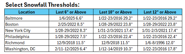
-
Extreme Cold, Snow & Sleet: SECS 1/24 - 1/26
donsutherland1 replied to TriPol's topic in New York City Metro
Latest QPF on the 1/21 0z NBM: Boston: 0.38" New York City: 0.54" Philadelphia: 0.90" Richmond: 2.00" Washington, DC: 1.11" -
Extreme Cold, Snow & Sleet: SECS 1/24 - 1/26
donsutherland1 replied to TriPol's topic in New York City Metro
Here's what I found upon looking. It seems there was a bit more to his reasoning than was perhaps implied. Having said that, I believe that there is still enough uncertainty associated with the lead time for a more phased/northward solution.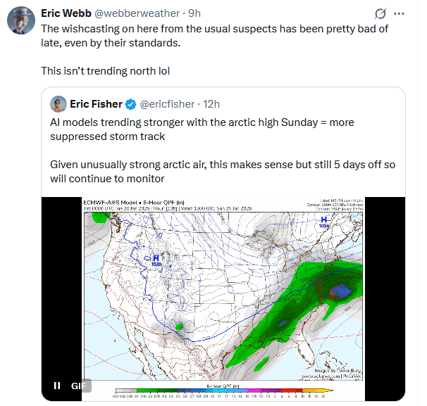
-
Extreme Cold, Snow & Sleet: SECS 1/24 - 1/26
donsutherland1 replied to TriPol's topic in New York City Metro
The 1/20 18z GFS showed better phasing as both the northern and southern branches of the jet stream were better aligned. The result is that snowfall got into the New York City area unlike with the 12z GFS. The 12z ECMWF, GGEM, and UKMET continued to show a snowier outcome for New York City. Historical data for 6" or above Washington DC January-February snowstorms also argues strongly against a shutout in the New York City area. Within the next day or two, model skill will improve and confidence in the solutions will increase. Key factors to be resolved: 1) Jet stream interaction/Degree of phasing 2) Strength and position of Arctic high and confluence There remains a risk of suppression and/or a sharp cutoff of precipitation on the northern edge of the storm. However, New York City and its suburbs still remain very much in the game for a moderate or significant snowfall, especially when the more skillful guidance is considered. The 1/21 0z runs will provide additional insight. -
Arctic air has moved into the region. The temperature will fall into the middle teens in New York City tonight. Some suburban areas could see single-digit lows. Tomorrow will be another unseasonably cold day, but the temperature will reach the lower and perhaps middle 30s. Thursday will be the warmest day of the week with highs reaching or suprassing 40°. However, an even colder Arctic front will cross the region on Thursday, possibly with some snow flurries or snow showers. A frigid weekend lies ahead. Snow could arrive on Sunday. The temperature could stay below 20° in New York City on Saturday. The last time that happened was January 21, 2025 when the high was 19°. Overall, January 20th-February 3rd will likely be the coldest and perhaps snowiest two-week period this winter. The forecast WPO-/EPO-/AO-/PNA+ pattern is typically the coldest pattern in January and among the coldest during the first half of February. A persistently positive PNA will have above climatological risk of moderate or significant snowfalls. The ENSO Region 1+2 anomaly was -0.3°C and the Region 3.4 anomaly was -0.7°C for the week centered around January 14. For the past six weeks, the ENSO Region 1+2 anomaly has averaged -0.48°C and the ENSO Region 3.4 anomaly has averaged -0.68°C. La Niña conditions will likely continue into at least late winter. The SOI was +17.11 today. The preliminary Arctic Oscillation (AO) was -1.705 today. Based on sensitivity analysis applied to the latest guidance, there is an implied near 97% probability that New York City will have a cooler than normal January (1991-2020 normal). January will likely finish with a mean temperature near 30.9° (2.8° below normal). Supplemental Information: The projected mean would be 1.7° below the 1981-2010 normal monthly value.