donsutherland1
-
Posts
23,768 -
Joined
Content Type
Profiles
Blogs
Forums
American Weather
Media Demo
Store
Gallery
Everything posted by donsutherland1
-
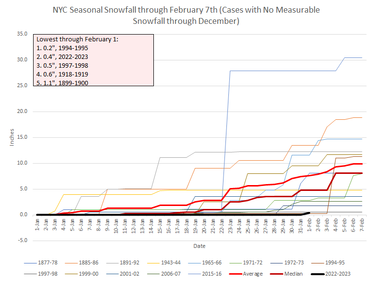
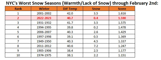
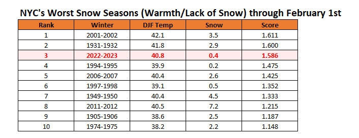
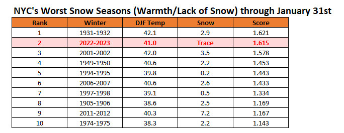
New York City's snow season futility rankings through February 2nd:
-
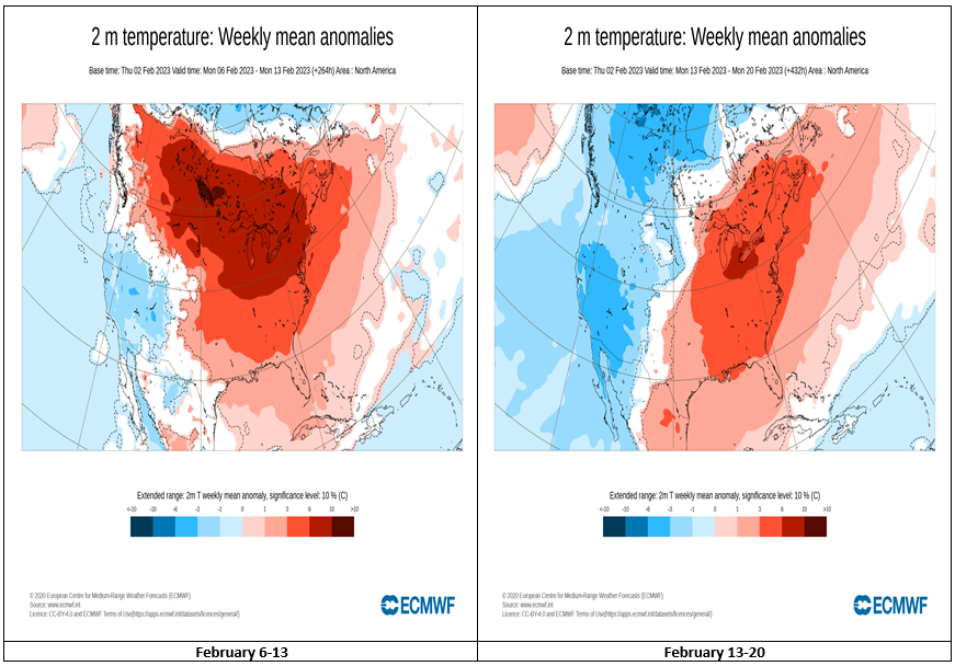
They get better, but they don’t show colder than normal weeks. Hopefully, they will be colder in subsequent cycles.
-
The latest EPS weeklies:
-
An Arctic cold front will move through the region late tonight. A few places could see a snow flurry or snow shower. Tomorrow will see the temperature fall throughout much of the day despite a return of sunshine. It will become increasingly windy. The weekend will start off on a bitterly cold note with the mercury rising only into the upper teens and lower 20s during the daytime after a morning low in the single digits to low teens in New York City and possibly below zero outside the City. In southern New England, Boston will likely see its first subzero temperature since January 7, 2018 when the temperature reached -2°. The potential exists for Boston to see a -5° or below temperature. The last time that happened was February 14, 2016 when the thermometer fell to -9°. Select Record Lows for February 4th: Boston: -2°, 1886 Bridgeport: 5°, 1955 and 1996 Montreal: -20°, 1963 New Haven: 4°, 1963 and 2011 New York City-JFK: 9°, 1955 nd 1996 New York City-LGA: 10°, 1955, 1963, 1978 and 1996 Portland: -19°, 1971 Providence: -2°, 1918 White Plains: 4°, 1978 As had been the case during the December Arctic shot in a winter of almost unbroken warmth, the upcoming Arctic shot will be a fleeting one. Just a day after the height of the cold, the temperature will rocket toward normal levels and then above normal levels a day later. The potential exists for temperatures to run above to much above normal through mid-month. Both the CFSv2 and EPS weeklies show much above normal temperatures through the second week of February. The ENSO Region 1+2 anomaly was -0.2°C and the Region 3.4 anomaly was -0.6°C for the week centered around January 25. For the past six weeks, the ENSO Region 1+2 anomaly has averaged -0.32°C and the ENSO Region 3.4 anomaly has averaged -0.70°C. La Niña conditions are beginning to fade and they should evolve to neutral conditions during late winter or early spring. The SOI was +18.16 today. The preliminary Arctic Oscillation (AO) was +0.105 today. On January 31 the MJO was in Phase 3 at an amplitude of 1.829 (RMM). The January 30-adjusted amplitude was 2.062 (RMM).
-
Morning thoughts… Today will be partly sunny and seasonably cold. Some flurries are possible late in the day or at night from an Arctic cold front. High temperatures will reach the upper 30s and lower 40s in most areas. Likely high temperatures around the region include: New York City (Central Park): 40° Newark: 42° Philadelphia: 41° Tomorrow will be sharply colder. After a very cold start to the weekend, temperatures will rebound strongly. Normals: New York City: 30-Year: 40.0°; 15-Year: 40.2° Newark: 30-Year: 40.6°; 15-Year: 40.9° Philadelphia: 30-Year: 41.8°; 15-Year: 41.9°
-
New York City's snow season futility rankings through February 1st:
-
They are from Manor Park in Larchmont.
-
You have my sincerest condolences.
-
You have my fullest condolences for the untimely passing of your mother.
-
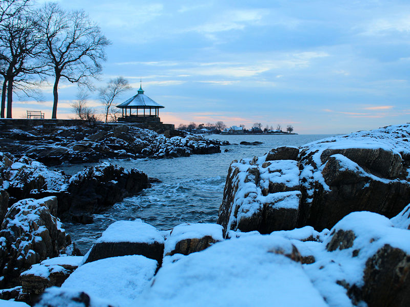
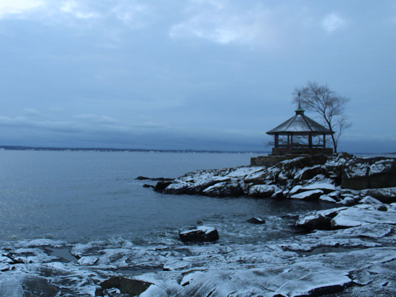
Two additional photos from today's light snowfall:
-
In the wake of the system that brought Baltimore, New York City (Central Park and JFK Airport), Philadelphia, and Washington, DC their first measurable snowfall of the season, a seasonably cold day will follow. A cooler than normal first week of February in what will likely be a warmer than normal month overall is underway. The developing cool period will be highlighted by a brief Arctic blast. Saturday could be the coldest day with the temperature rising only into the upper teens and lower 20s during the daytime after a morning low in the single digits to low teens in New York City and possibly below zero outside the City. Afterward, moderation will rapidly commence. The potential exists for temperatures to run above to much above normal through mid-month. Both the CFSv2 and EPS weeklies show much above normal temperatures for the second week of February. The ENSO Region 1+2 anomaly was -0.2°C and the Region 3.4 anomaly was -0.6°C for the week centered around January 25. For the past six weeks, the ENSO Region 1+2 anomaly has averaged -0.32°C and the ENSO Region 3.4 anomaly has averaged -0.70°C. La Niña conditions are beginning to fade and they should evolve to neutral conditions during late winter or early spring. The SOI was +6.22 today. The preliminary Arctic Oscillation (AO) was +0.911 today. On January 30 the MJO was in Phase 3 at an amplitude of 2.072 (RMM). The January 29-adjusted amplitude was 2.458 (RMM).
-
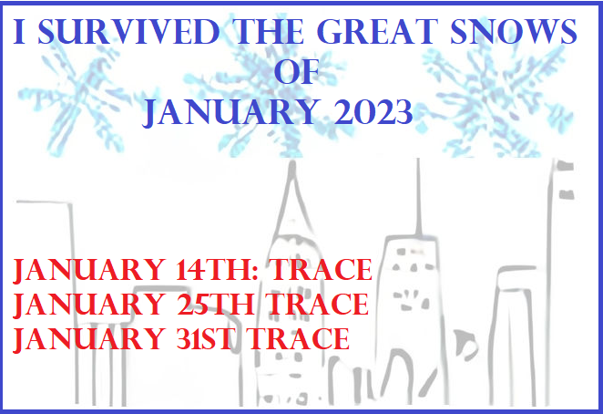
JFK Airport recorded its first measurable snow of the season today with 0.2”.
-
Yes, 28 was the coldest. That set a new monthly minimum record.
-
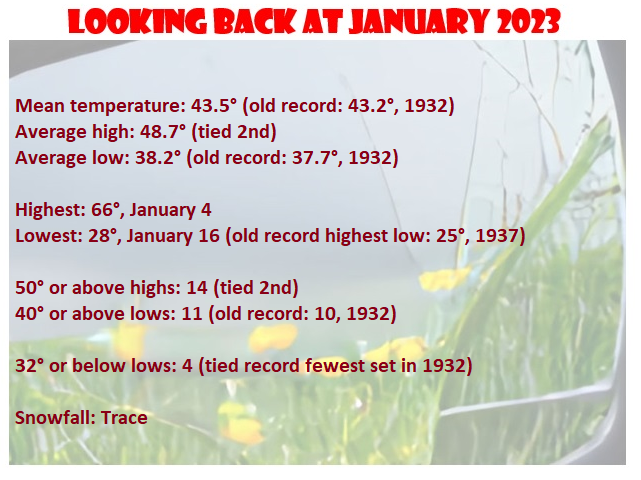
I don’t have a total from JFK, yet. I suspect JFK had 0.3”-0.5”, but we’ll know once the NWS reports the amount. 1950 has the record of 15 50-degree days in January.
-
We’ll probably drop a little due to the coming cold.
-
The February record is 42.0 from 2018. November and December 2015 set records. However, the November record was broken again in 2020. Currently, no year holds 2 consecutive monthly high or low temperature records.
-
No. Those are the 1961-90 and 1991-20 averages.
-
The highest average maximum temperature was 49.1, which was set in 1950.
-
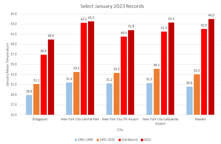
Select January monthly records:
-
There were 6 90° or above days, including a 97° day on September 8th.
-
New York City's snow season futility rankings through January 31st:
-
They are relative to the base periods used by NOAA. I believe 1869 was relative to the 1871-00 period. The anomalies are from the NOAA’s data.