donsutherland1
-
Posts
23,767 -
Joined
Content Type
Profiles
Blogs
Forums
American Weather
Media Demo
Store
Gallery
Everything posted by donsutherland1
-
Perhaps. Doubtful in Manhattan, Queens, Brooklyn, and Staten Island.
-
Very unlikely for NYC. Perhaps in some of the suburbs there will be delayed openings and maybe some closures.
-
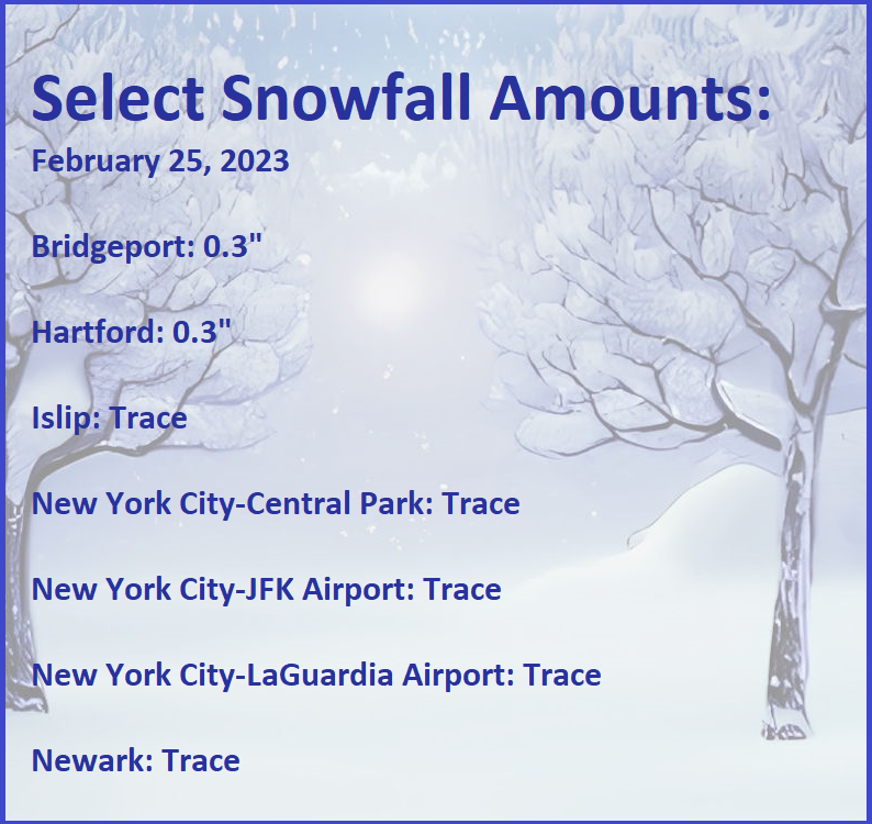
Morning thoughts… Today will become mostly cloudy. Snow will overspread the region this evening. New York City and Newark will see a general 1”-3”, areas just outside New York City will pick up 2”-4”, and the far northern and western suburbs will see 3”-6”. Snow will likely mix with and change to rain along the coast. High temperatures will reach the lower 40s in most of the region. Likely high temperatures around the region include: New York City (Central Park): 41° Newark: 43° Philadelphia: 46° Precipitation will end tomorrow. Normals: New York City: 30-Year: 44.8°; 15-Year: 45.1° Newark: 30-Year: 45.8°; 15-Year: 46.2° Philadelphia: 30-Year: 47.3°; 15-Year: 47.3°
-
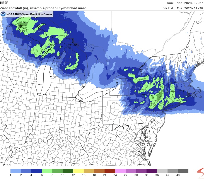
The 0z HREF:
-
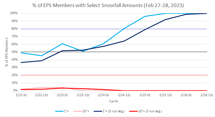
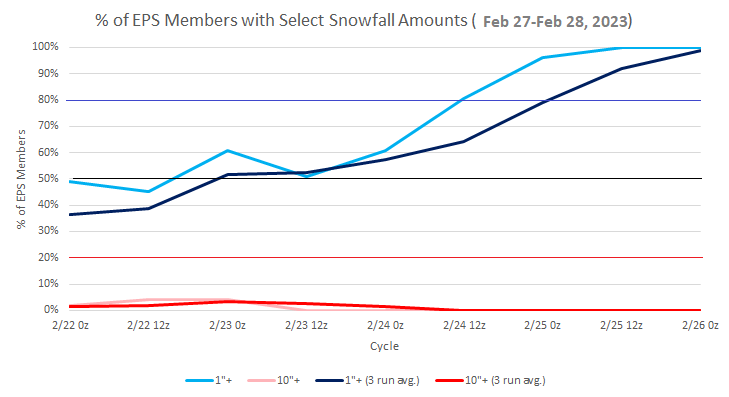
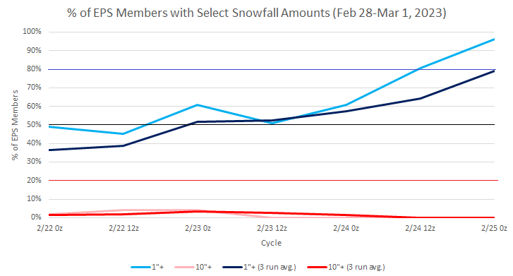
100% of EPS members continue to show 1" or more snow for New York City. The 20z National Blend of Models ranges from 1.2" at JFK Airport to 2.4" at Central Park.
-
Colder air will begin filtering into the region overnight. That will set the stage for the area's biggest snowfall so far this season. At present, it appears that New York City and Newark are in line for 1"-3" of snow before the precipitation changes to rain. Immediately north and west of the City, 2"-4" is likely. In the far northern suburbs, 3"-6" of snow is likely. Another storm is possible in the March 3-4 timeframe. The guidance has grown milder for the first week of March. The EPS now suggests readings could wind up somewhat above normal. The latest ECMWF weekly forecast suggests that the second week of March could transition toward a colder regime that could last into the closing week of March. The ENSO Region 1+2 anomaly was +0.8°C and the Region 3.4 anomaly was -0.5°C for the week centered around February 15. For the past six weeks, the ENSO Region 1+2 anomaly has averaged +0.15°C and the ENSO Region 3.4 anomaly has averaged -0.56°C. La Niña conditions fading and they should evolve to neutral conditions during late winter or early spring. The SOI was +15.08 today. The preliminary Arctic Oscillation (AO) was +2.547 today. On February 24 the MJO was in Phase 7 at an amplitude of 1.066 (RMM). The February 23-adjusted amplitude was 1.066 (RMM). Based on sensitivity analysis applied to the latest guidance, there is an implied near 100% probability that New York City will have a warmer than normal February (1991-2020 normal). February will likely finish with a mean temperature near 41.2° (5.3° above normal).
-
45/51 (88%) of EPS members have 1" or more for JFK Airport. The 16z NBM shows 1.2".
-
Yes. That's the record.
-
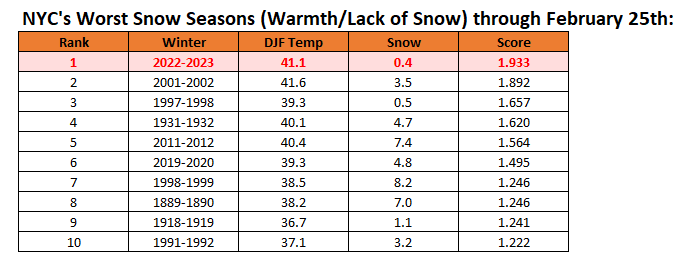
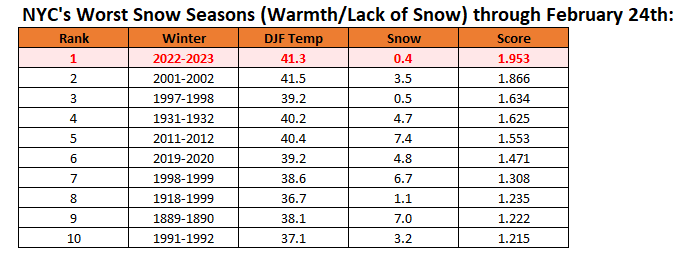
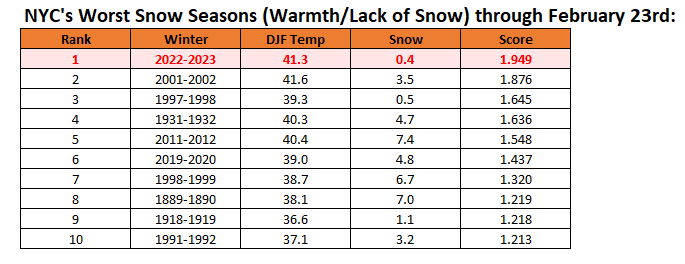
New York City's snow season futility rankings through February 25th: That will change by the end of Monday. 100% of EPS members now show 1" or more snow for NYC. The National Blend of Models has 2.1" (11z run).
-
In the wake of today's light snow that brought coatings outside New York City and Newark, clouds will break overnight. Much milder air will return tomorrow. Afterward, another system could bring snow changing to rain to the region. At present areas just to the north and west of New York City could see 1"-3" Monday into Monday night. Areas well north and west of the City could pick up 3"-6". The guidance has grown milder for the first week of March. The EPS now suggests readings could wind up somewhat above normal. The latest ECMWF weekly forecast suggests that the second week of March could transition toward a colder regime that could last into the closing week of March. The ENSO Region 1+2 anomaly was +0.8°C and the Region 3.4 anomaly was -0.5°C for the week centered around February 15. For the past six weeks, the ENSO Region 1+2 anomaly has averaged +0.15°C and the ENSO Region 3.4 anomaly has averaged -0.56°C. La Niña conditions fading and they should evolve to neutral conditions during late winter or early spring. The SOI was +13.93 today. The preliminary Arctic Oscillation (AO) was +3.506 today. On February 23 the MJO was in Phase 7 at an amplitude of 1.066 (RMM). The February 22-adjusted amplitude was 1.209 (RMM). Based on sensitivity analysis applied to the latest guidance, there is an implied near 100% probability that New York City will have a warmer than normal February (1991-2020 normal). February will likely finish with a mean temperature near 41.2° (5.3° above normal).
-
A trace.
-
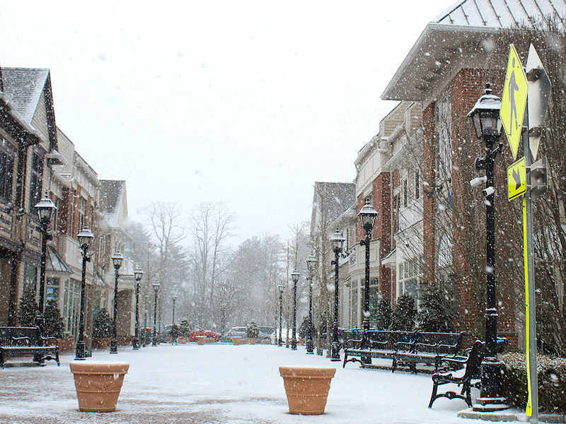
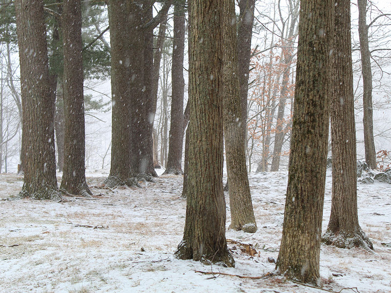
Two photos of the period of snow in Armonk, New York.
-
Snow is through the whole season. At the end, I can post with Dec-Feb temperatures and Dec-March temperatures.
-
Morning thoughts… Today will be mostly cloudy with some light snow and flurries. A minor accumulation is possible. High temperatures will reach the lower and middle 30s in most of the region. Likely high temperatures around the region include: New York City (Central Park): 33° Newark: 35° Philadelphia: 36° Milder air will return tomorrow. Normals: New York City: 30-Year: 44.3°; 15-Year: 44.5° Newark: 30-Year: 45.3°; 15-Year: 45.6° Philadelphia: 30-Year: 46.7°; 15-Year: 46.6°
-
New York City's snow season futility rankings through February 24th Although some areas could be dusted today, the ensembles suggest a good chance of some accumulating snow for Monday.
-
Blustery winds are pushing colder air into the region. Farther south, more record warmth occurred today. Daily records included: Charleston, SC: 86° (old record: 84°, 2022) Savannah: 86° (tied record set in 2012) Wilmington, NC: 85° (old record: 81°, 1982) Wilmington recorded its second consecutive 85° or above reading. The previous earliest such occurrence was March 2-3, 1976. Wilmington also registered its 3rd consecutive 80° or above temperature for the first time in February. The earliest such occurrence was March 1-3, 1976. The weekend could start off with a fairly sharp cold shot. Some light snow or snow showers are possible tomorrow into early Sunday. Any accumulations will be light. Milder air will rapidly return on Sunday. The guidance has grown milder for the first week of March. The EPS now suggests readings could wind up somewhat above normal. The latest ECMWF weekly forecast suggests that the second week of March could transition toward a colder regime that could last into the closing week of March. In terms of snowfall prospects, a reasonable window of opportunity exists during the February 27-March 1 timeframe. EPS ensemble members have recently consolidated around that timeframe with about half of members showing 1" or more in New York City. Central New England and northern New England could see substantial snowfall. Odds favor a light snowfall in New York City and Newark, should it occur. The ENSO Region 1+2 anomaly was +0.8°C and the Region 3.4 anomaly was -0.5°C for the week centered around February 15. For the past six weeks, the ENSO Region 1+2 anomaly has averaged +0.15°C and the ENSO Region 3.4 anomaly has averaged -0.56°C. La Niña conditions fading and they should evolve to neutral conditions during late winter or early spring. The SOI was +1.49 today. The preliminary Arctic Oscillation (AO) was +2.359 today. On February 22 the MJO was in Phase 7 at an amplitude of 1.211 (RMM). The February 21-adjusted amplitude was 1.321 (RMM). Based on sensitivity analysis applied to the latest guidance, there is an implied near 100% probability that New York City will have a warmer than normal February (1991-2020 normal). February will likely finish with a mean temperature near 41.2° (5.3° above normal).
-
Today's record low for NYC is -1° from 1873.
-
Some quick statistics:
-
Morning thoughts… Today will be partly cloudy. Temperatures will fall during the afternoon. High temperatures will reach the lower and middle 40s in most of the region. Likely high temperatures around the region include: New York City (Central Park): 44° Newark: 46° Philadelphia: 49° A sharp but brief cold shot is likely this weekend. Normals: New York City: 30-Year: 44.1°; 15-Year: 44.3° Newark: 30-Year: 45.1°; 15-Year: 45.3° Philadelphia: 30-Year: 46.5°; 15-Year: 46.3°
-
New York City's snow season futility rankings through February 23rd:
-
He’s referring to the upcoming March.
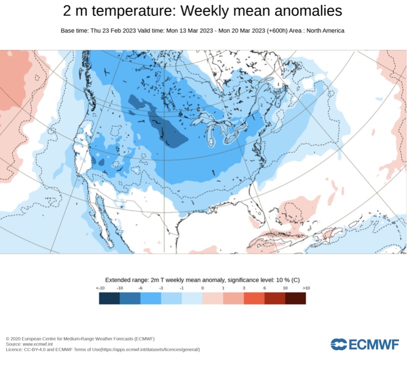
-
The ECMWF weeklies for March 13-20.
-
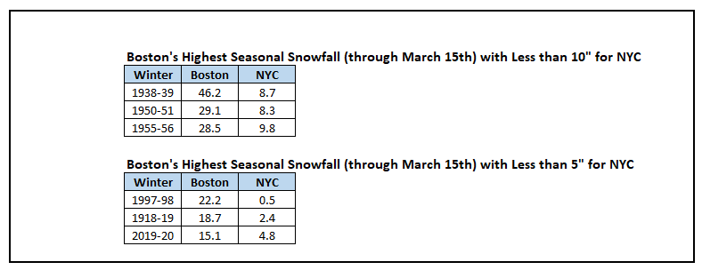
A stalled warm front cloaked the New York City and Newark areas in murky, chilly conditions. North of the front, parts of New England saw snow. Boston picked up 1.2" (triple New York City's seasonal snowfall to date). South of the front, record warmth prevailed. Numerous locations set new monthly record high temperatures. Record highs included: Athens, GA" 80° (old record: 79°, 1980, 2012, 2017, and 2018) Baltimore: 79° (old record: 78°, 1874) Charlotte: 80° (old record: 79°, 2018) Columbia: 83° (old record: 82°, 1962 and 2018) Elizabeth City, NC: 83° (old record: 77°, 1975) ***New February Record*** Jacksonville: 88° (old record: 85°, 1962) Lynchburg: 79° (old record: 74°, 1943) Macon: 84° (old record: 82°, 2022) Norfolk: 81° (old record: 79°, 1975) Pensacola: 83° (old record: 79°, 1994 and 2017) ***New February Record*** Raleigh: 85° (old record: 79°, 1980) ***New February Record*** Richmond: 83° (old record: 75°, 1925, 1985, and 2017) ***Tied February Record*** Savannah: 85° (old record: 84°, 2012 and 2022) Sterling, VA: 80° (old record: 77°, 2017) Washington, DC: 81° (old record: 78°, 1874) Wilmington, NC: 86° (old record: 82°, 2022) ***New February Record*** Temperatures will run generally above normal through the much of the remainder of February. No severe shots of cold appear likely through February, though the weekend could start off with a fairly sharp cold shot. Among the extended range scenarios on the table is a late February-early March 2002-type outcome. Under such a scenario, cold air would flood into the Plains States, but persistent southeast ridging would keep most of the cold away from the northeastern and Mid-Atlantic United States. During February 28-March 5, 2002 high temperatures in the New York City area generally reached the lower to middle 40s with low temperatures in the 20s at night. At the height of the cold, one night saw the temperature fall into the upper teens. By March 7, the cold was gone and readings returned to much above normal levels. The guidance has grown milder for the first week of March. The EPS now suggests readings could wind up above normal. The latest ECMWF weekly forecast suggests that the second week of March could transition toward a colder regime that could last into the closing week of March. In terms of snowfall prospects, a reasonable window of opportunity exists during the February 28-March 1 timeframe. EPS ensemble members have recently consolidated around that timeframe with about half of members showing 1" or more in New York City. Central New England and northern New England could see substantial snowfall. Odds favor a light snowfall in New York City and Newark, should it occur. The ENSO Region 1+2 anomaly was +0.8°C and the Region 3.4 anomaly was -0.5°C for the week centered around February 15. For the past six weeks, the ENSO Region 1+2 anomaly has averaged +0.15°C and the ENSO Region 3.4 anomaly has averaged -0.56°C. La Niña conditions fading and they should evolve to neutral conditions during late winter or early spring. The SOI was -16.91 today. The preliminary Arctic Oscillation (AO) was +1.098 today. On February 21 the MJO was in Phase 7 at an amplitude of 1.329 (RMM). The February 20-adjusted amplitude was 1.543 (RMM). Based on sensitivity analysis applied to the latest guidance, there is an implied near 100% probability that New York City will have a warmer than normal February (1991-2020 normal). February will likely finish with a mean temperature near 41.3° (5.4° above normal).
-
Thank you, GaWx. Tropical Tidbits needs to update its baseline, in this case. The 1981-2010 baseline is no longer being used. So, at present, the issues that exist with the maps that I'm now aware of are: 1. TT uses an incorrect baseline on its maps where anomalies are shown (its snow algorithm continues to treat sleet and freezing rain as snow in the 10:1 totals) 2. WxBell uses the CFSv2 as an operational model rather than averaging over multiple runs