donsutherland1
-
Posts
23,782 -
Joined
Content Type
Profiles
Blogs
Forums
American Weather
Media Demo
Store
Gallery
Everything posted by donsutherland1
-
Winter cancelled/uncancelled banter 25/26
donsutherland1 replied to Rjay's topic in New York City Metro
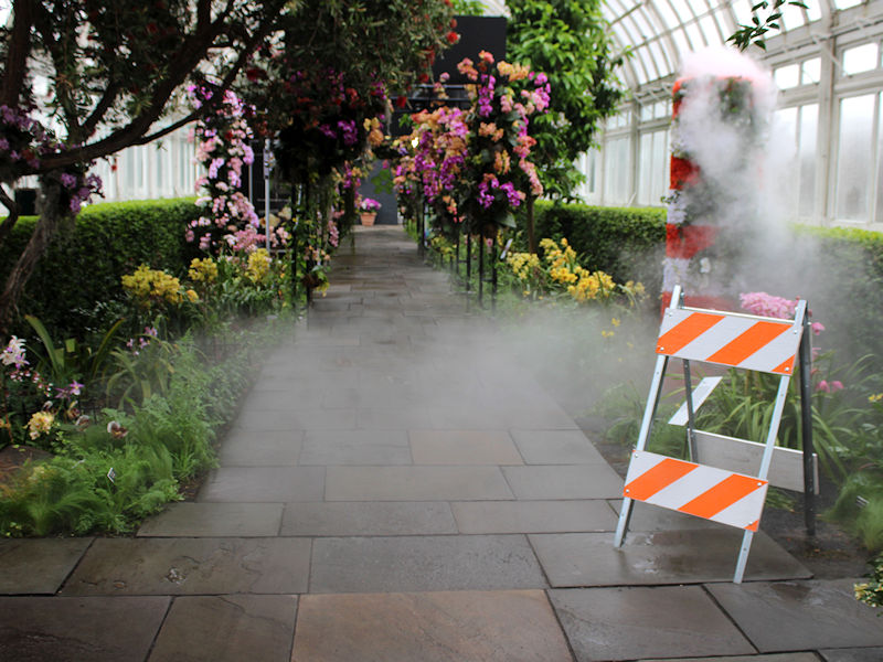
Crocuses, snowdrops, and witch hazel are now in bloom at the New York Botanical Garden. Inside, the Orchid Show, which features a reimagining of New York City, is underway. Seven photos: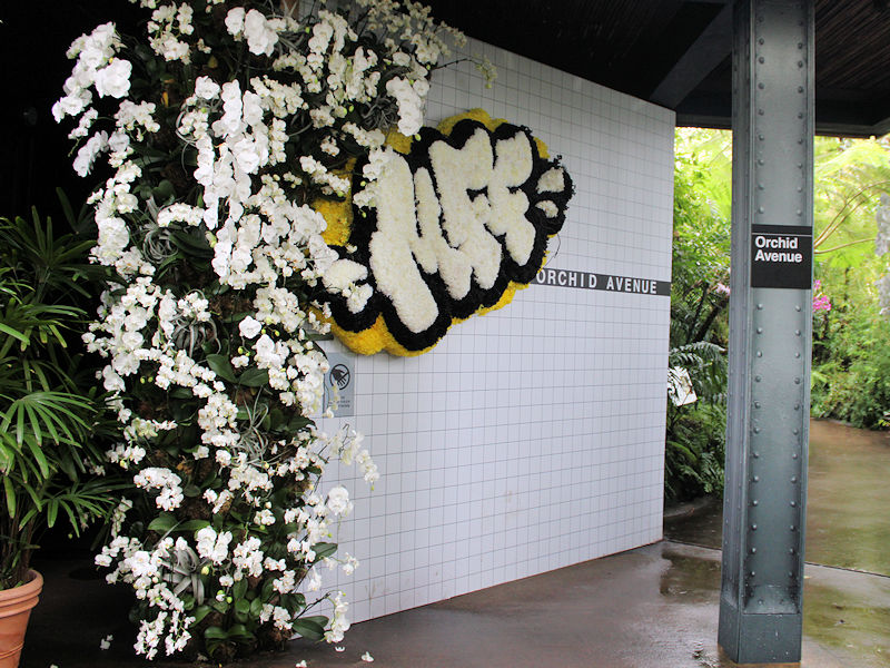


-
2026-2027 El Nino
donsutherland1 replied to Stormchaserchuck1's topic in Weather Forecasting and Discussion
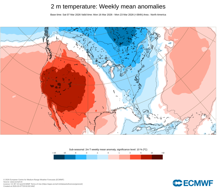
This isn't the end of the March weather story: While Phoenix may be approaching or even reaching 100° on one or more days shortly after mid-month, a fairly sharp shot of cold is likely from the Great Lakes Region into the Northeast during March 15-20. Detroit may see the low temperature fall into the teens on one or more days. New York City could see low to mid 20s. Without blocking, the cold probably won't be sustained for too long, but that doesn't necessarily mean things will torch afterward. The highest probability for a continuation of warmth is in the Southwest on account of a largely "stuck" pattern.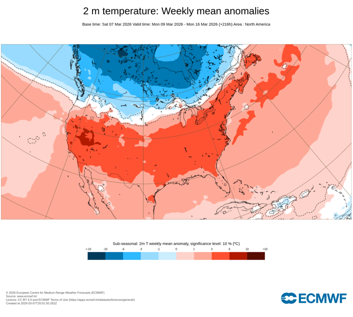
-
NOUS41 KOKX 062000 PNSOKX CTZ005>012-NJZ002-004-006-103>108-NYZ067>075-078>081-176>179- 080800- Public Information Statement National Weather Service New York NY 300 PM EST Fri Mar 6 2026 ...BLIZZARD CONFIRMED FOR NEW YORK CITY, LONG ISLAND, COASTAL WESTCHESTER, COASTAL CONNECTICUT, AND PORTIONS OF NORTHEASTERN NEW JERSEY... The National Weather Service in New York, NY can preliminarily confirm that blizzard criteria was met on February 23rd across the following counties... Manhattan, NY Queens, NY Kings, NY Richmond, NY Bronx, NY Nassau, NY Suffolk, NY Southern Westchester, NY Southern Fairfield, CT Southern New Haven, CT Southern Middlesex, CT Southern New London, CT Eastern Bergen, NJ Eastern Essex, NJ Eastern Union, NJ Hudson, NJ Blizzard criteria are met when sustained winds or frequent gusts of at least 35 mph accompanied by falling and/or blowing snow frequently reduce visibility to less than 1/4 mile for 3 or more hours during an event. The exact start and end times of blizzard conditions in these areas will be documented in NWS StormData. Further analysis will also be conducted to determine if any additional zones reached blizzard criteria with this event. All verification data are considered preliminary until certified in NWS StormData. Please see the following preliminary storm event webpage for more details on this event: https://www.weather.gov/okx/20260222_23 $$
-
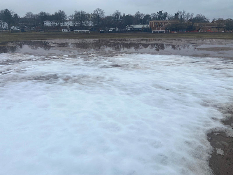
Fast retreating snow cover:
-
2026-2027 El Nino
donsutherland1 replied to Stormchaserchuck1's topic in Weather Forecasting and Discussion
If Phoenix reaches 100°, it would be extraordinary. Since March daily records started in 1896, Phoenix has hit 100° just once in March (March 26, 1988: 100°) and 99° three times (most recently on March 25, 2025). -
Phoenix Experiences Warmest February and Winter on Record
donsutherland1 replied to donsutherland1's topic in Climate Change
Yes. There's a strong indication of heat on the guidance.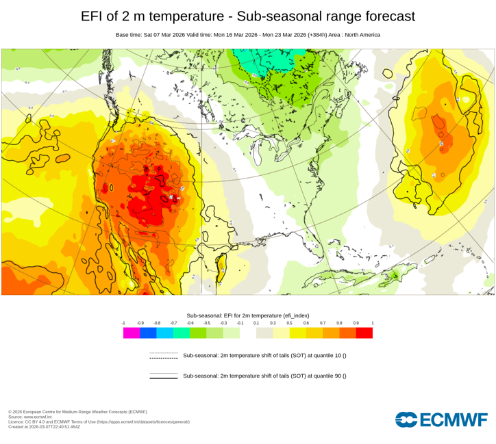
-
I expect it will wind up warmer. I think the warming post 3/21 isn't adequately reflected, but we'll see.
-
A once great blanket of snow now lies in scattered, broken fragments. Across the landscape, winter’s grip is breaking. Large, weathered piles of snow, grayed by time and road dust, stand as the last monuments to the winter that was. Soon, these remnants will surrender to the strengthening sun and the season's inexorable rise in temperatures. One by one they will dissolve into water, soaking into the ground or running along the sides of streets. With their departure, the last visible traces of the season’s story will disappear from an increasingly colorful landscape that will emerge as the calendar presses deeper into spring. Following some early fog, tomorrow will provide an early taste of spring. Clouds will break and the temperature will surge into the lower and perhaps middle 60s across much of the region. The eastern half of Long Island and south shores of Long Island and Connecticut will remain markedly cooler. Interior sections of New Jersey could see the mercury approach or reach 70°. The first half of next week will likely see highs in the 60s. Some 70s are possible in the warmer spots, especially in interior New Jersey. Long Island and coastal sections could be noticeably cooler than interior sections on a number of days on account of a chilly onshore flow. Afterward, it could turn cooler. However, with the AO likely to remain generally positive, the cool period likely won't be as prolonged as had been the case during this past winter's cold regimes. There may be a short window of opportunity for some snow, but snow is not assured. The ENSO Region 1+2 anomaly was +1.0°C and the Region 3.4 anomaly was -0.1°C for the week centered around February 25. For the past six weeks, the ENSO Region 1+2 anomaly has averaged +0.62°C and the ENSO Region 3.4 anomaly has averaged -0.28°C. Neutral ENSO conditions have now developed. Neutral ENSO conditions will continue through at least mid-spring. The SOI was +30.11 today. The preliminary Arctic Oscillation (AO) was +2.140 today. Based on sensitivity analysis applied to the latest guidance, there is an implied 56% probability that New York City will have a warmer than normal March (1991-2020 normal). March will likely finish with a mean temperature near 43.6° (0.8° above normal). Supplemental Information: The projected mean would be 1.1° above the 1981-2010 normal monthly value.
-
Phoenix Experiences Warmest February and Winter on Record
donsutherland1 replied to donsutherland1's topic in Climate Change
For a further illustration of how remarkable the warmth has been in recent years, seven months have now seen their highest average temperature set since 2020. So far, no records have been set in any of the spring months. However, there is a chance that could change this month. With its sizzling start and possible near-record/record heat next week, 2026 is very likely to finish among the 10 warmest years on record in March. A new record is possible should the predominant winter pattern persist through much of the month.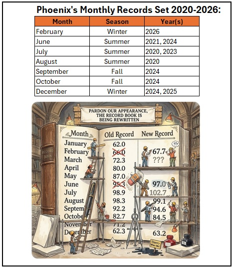
-
Shorter wave lengths change the importance of various teleconnections. Some have difficulty accepting that there are no universal patterns that apply at all times. Some on X/Twitter were insisting on the importance of a PNA+ ahead of the recent blizzard. Undoubtedly, they must be confounded that it occurred with a strongly negative PNA. But not those who understand the synoptic patterns. During the second half of February, a PNA- is more conducive to big Northeast snowstorms.
-
An early taste of spring is imminent. It will turn noticeably warmer during the weekend. The temperature will likely surge into the lower 50s tomorrow and then lower 60s on Sunday. The first half of next week will likely see highs in the 60s. Some 70s are possible in the warmer spots, especially in interior New Jersey. Long Island and coastal sections could be noticeably cooler than interior sections on a number of days on account of a chilly onshore flow. Afterward, it could turn cooler. However, with the AO likely to remain generally positive, the cool period likely won't be as prolonged as had been the case during this past winter's cold regimes. The ENSO Region 1+2 anomaly was +1.0°C and the Region 3.4 anomaly was -0.1°C for the week centered around February 25. For the past six weeks, the ENSO Region 1+2 anomaly has averaged +0.62°C and the ENSO Region 3.4 anomaly has averaged -0.28°C. Neutral ENSO conditions have now developed. Neutral ENSO conditions will continue through at least mid-spring. The SOI was +25.51 today. The preliminary Arctic Oscillation (AO) was +1.318 today.
-
Periods of rain will continue into tomorrow. A storm total 0.50"-1.50" rainfall is likely across much of the region. Highs will likely reach the lower 40s tomorrow and Friday. It will turn noticeably warmer during the weekend. Long Island and coastal sections could be noticeably cooler than interior sections on a number of days on account of a chilly onshore flow. The ENSO Region 1+2 anomaly was +1.0°C and the Region 3.4 anomaly was -0.1°C for the week centered around February 25. For the past six weeks, the ENSO Region 1+2 anomaly has averaged +0.62°C and the ENSO Region 3.4 anomaly has averaged -0.28°C. Neutral ENSO conditions have now developed. Neutral ENSO conditions will continue through at least mid-spring. The SOI was +13.59 today. The preliminary Arctic Oscillation (AO) was +1.072 today.
-
Dry weather will be short-lived. Additional rain will arrive tomorrow and continue into Friday. A general 0.50"-1.50" rainfall is likely. Highs will likely reach the lower 40s tomorrow and Friday. It will turn noticeably warmer during the weekend. Long Island and coastal sections could be noticeably cooler than interior sections on a number of days on account of a chilly onshore flow. The ENSO Region 1+2 anomaly was +1.0°C and the Region 3.4 anomaly was -0.1°C for the week centered around February 25. For the past six weeks, the ENSO Region 1+2 anomaly has averaged +0.62°C and the ENSO Region 3.4 anomaly has averaged -0.28°C. Neutral ENSO conditions have now developed. Neutral ENSO conditions will continue through at least mid-spring. The SOI was +19.53 today. The preliminary Arctic Oscillation (AO) was +1.240 today.
-
Occasional Thoughts on Climate Change
donsutherland1 replied to donsutherland1's topic in Climate Change
Brunswick 23S (2005-2025), Newton 11 SW (2003-2025), Newton 8W (2003-2025) are warming about 0.9°/decade. That matches Georgia's statewide warming during 2003-2025/2005-2025. Watkinsville 5 SSE (2005-2025) is warming 0.6°/decade, which is somewhat slower than the statewide average. -
Periods of rain are likely into early tomorrow. The temperature will reach the middle and upper 40s tomorrow. Additional rain is likely on Thursday into Friday. Highs will likely reach the lower 40s on both days. It will turn noticeably warmer during the weekend. Long Island and coastal sections could be noticeably cooler than interior sections on a number of days on account of a chilly onshore flow. The ENSO Region 1+2 anomaly was +1.0°C and the Region 3.4 anomaly was -0.1°C for the week centered around February 25. For the past six weeks, the ENSO Region 1+2 anomaly has averaged +0.62°C and the ENSO Region 3.4 anomaly has averaged -0.28°C. Neutral ENSO conditions have now developed. Neutral ENSO conditions will continue through at least mid-spring. The SOI was +19.34 today. The preliminary Arctic Oscillation (AO) was +0.253 today.
-
Should the AO stay positive, it will probably be a one-week or so window of opportunity. If, however, blocking develops, then the probability of a multi-week cold period would increase. Hopefully, we can get a decent storm during the window of opportunity.
-
Yes, you can use it.
-
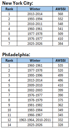
Here’s a link: https://mrcc.purdue.edu/research/awssi
-
Here's the data: Note: The Index begins with 1950-51. Moreover, lots of data are missing e.g., 1995-1996 for New York City. The short timespan and missing data limit the Index's value.
-
Clouds will increase tonight and cloud cover will likely impede viewing of the lunar eclipse near sunrise tomorrow. Periods of mixed precipitation giving way to periods of rain are likely later Tuesday and Tuesday night. The temperature will reach the upper 30s and lower 40s. A sustained warming trend will commence on Wednesday. The second week of March could feature springlike readings. Long Island and coastal sections could be noticeably cooler than interior sections on a number of days on account of a chilly onshore flow. The ENSO Region 1+2 anomaly was +1.0°C and the Region 3.4 anomaly was -0.1°C for the week centered around February 25. For the past six weeks, the ENSO Region 1+2 anomaly has averaged +0.62°C and the ENSO Region 3.4 anomaly has averaged -0.28°C. Neutral ENSO conditions have now developed. Neutral ENSO conditions will continue through at least mid-spring. The SOI was +16.18 today. The preliminary Arctic Oscillation (AO) was -0.670 today.
-
Phoenix Experiences Warmest February and Winter on Record
donsutherland1 replied to donsutherland1's topic in Climate Change
For what it's worth, it appears that global temperatures explain a larger share of Phoenix's (and perhaps the Southwest's) annual temperature variance than they do for such cities as New York.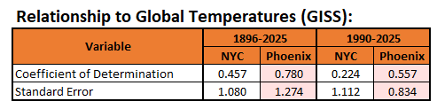
-
Here's the Top 30 data for through March 1st. The ranking is higher, as I excluded years with 25 or more missing days. Their inclusion previously skewed some of the results. I also used average of days (not months) when calculating the DJF mean temperature. That also led to minor adjustments from the prior list e.g., 1854-55 had a mean temperature of 29.1° vs. 29.0° (when all months were weighted equally). Rank Winter DJF Temp Snow Score 1 1872-1873 25.7 62.5 -2.225 2 1867-1868 25.0 53.3 -2.027 3 1904-1905 25.4 49.8 -1.856 4 1960-1961 30.6 69.5 -1.752 5 1917-1918 24.9 42.3 -1.684 6 1855-1856 26.4 46.8 -1.616 7 1947-1948 28.9 57.6 -1.609 8 1919-1920 26.7 45.9 -1.544 9 1977-1978 28.7 52.9 -1.485 10 1874-1875 25.6 38.9 -1.474 11 1864-1865 27.9 49.0 -1.473 12 1995-1996 31.6 62.8 -1.392 13 2013-2014 31.3 60.5 -1.360 14 1922-1923 28.9 48.9 -1.327 15 2010-2011 32.8 66.0 -1.324 16 1903-1904 24.7 29.9 -1.311 17 1906-1907 28.9 46.9 -1.262 18 1993-1994 31.0 55.8 -1.250 19 1853-1854 30.7 53.0 -1.203 20 1851-1852 28.0 41.0 -1.199 21 2025-2026 31.7 54.5 -1.108 22 1866-1867 29.8 46.0 -1.104 23 1854-1855 29.1 42.5 -1.090 24 1933-1934 28.0 37.0 -1.069 25 1876-1877 27.9 35.4 -1.032 26 1859-1860 29.4 41.4 -1.012 27 1856-1857 27.9 34.5 -1.002 28 2002-2003 30.7 44.8 -0.936 29 1898-1899 29.2 36.5 -0.881 30 1870-1871 29.6 37.1 -0.844
-
Thanks. I wasn't aware of it either.
-
With an AO+ likely to prevail through at least mid-March, there seems to be no mechanism that could drive the cold from Canada into the New York City area. Some fleeting cool shots are possible, but a sustained very cold regime appears unlikely. That means prospects for a 50.0" or above snow season at Central Park will decrease markedly. The percentage of cases with sufficient snowfall (6.6") to raise the seasonal total to 50.0" or above are below: On or after 3/15: 10.8% On or after 3/20: 6.3% On or after 3/25: 2.5% No meaningful snowfall is likely through at least March 15th.