donsutherland1
-
Posts
23,765 -
Joined
Content Type
Profiles
Blogs
Forums
American Weather
Media Demo
Store
Gallery
Everything posted by donsutherland1
-
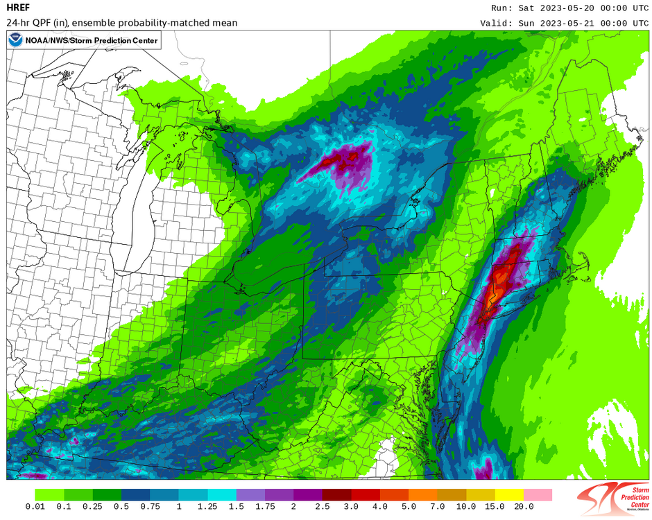
The 5/20 0z HREF remains very aggressive with the rainfall around and just north of New York City.
-
Readings will continue to warm during the weekend, but a significant rainfall is likely across much of the region tomorrow into Sunday. The region will likely see a general 1"-2" of rain with locally higher amounts. A stripe of 2"-4" of rain is possible across parts of New England. It should be noted that both the operational ECMWF and its ensemble members show very little rain for the New York City area. However, at this range, the HREF often has a better handle, though it could be somewhat overdone. Some of the guidance suggests that temperatures could return to the 80s to close the month. Typically, a very warm April is followed by a somewhat cooler than normal May in the Middle Atlantic region. Nevertheless, the guidance has persistently suggested that the month will end with a somewhat warmer than normal average. The ENSO Region 1+2 anomaly was +2.4°C and the Region 3.4 anomaly was +0.5°C for the week centered around May 10. For the past six weeks, the ENSO Region 1+2 anomaly has averaged +2.57°C and the ENSO Region 3.4 anomaly has averaged +0.28°C. Neutral ENSO conditions will likely prevail through at least mid-spring. El Niño conditions will very likely develop during the summer. The SOI was -9.48 today. The preliminary Arctic Oscillation (AO) was +2.585 today. On May 17 the MJO was in Phase 6 at an amplitude of 1.458 (RMM). The May 16-adjusted amplitude was 1.765 (RMM). Based on sensitivity analysis applied to the latest guidance, there is an implied 53% probability that New York City will have a warmer than normal May (1991-2020 normal). May will likely finish with a mean temperature near 63.3° (0.1° above normal).
-
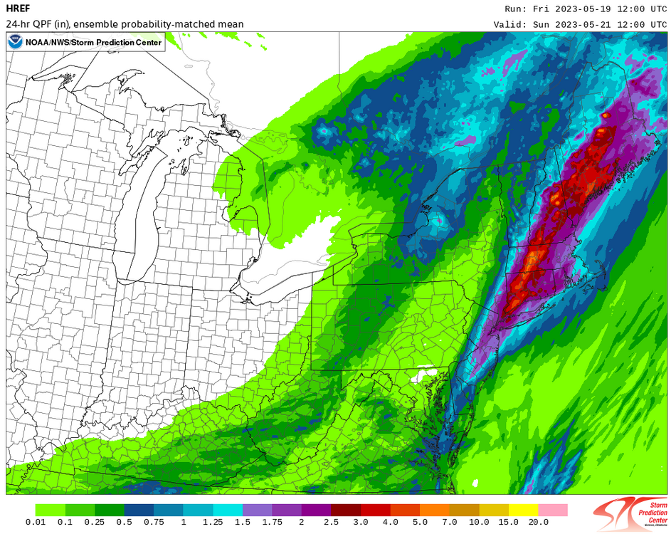
HREF for tomorrow's rainfall:
-
Unseasonably cool readings prevailed following a morning with near record and record cold. However, the coldest air is now in the past. Slow moderation will commence tomorrow. Readings will continue to warm during the weekend, but rain is possible. Parts of the region could see a general 0.25"-0.75" of rain with some higher amounts. A stripe of 1"-2" of rain is possible across eastern New England. Some of the guidance suggests that temperatures could return to the 80s to close the month. Typically, a very warm April is followed by a somewhat cooler than normal May in the Middle Atlantic region. Nevertheless, the guidance has persistently suggested that the month will end with a somewhat warmer than normal average. The ENSO Region 1+2 anomaly was +2.4°C and the Region 3.4 anomaly was +0.5°C for the week centered around May 10. For the past six weeks, the ENSO Region 1+2 anomaly has averaged +2.57°C and the ENSO Region 3.4 anomaly has averaged +0.28°C. Neutral ENSO conditions will likely prevail through at least mid-spring. El Niño conditions will very likely develop during the summer. The SOI was -9.86 today. The preliminary Arctic Oscillation (AO) was +2.333 today. On May 16 the MJO was in Phase 6 at an amplitude of 1.765 (RMM). The May 15-adjusted amplitude was 1.458 (RMM). Based on sensitivity analysis applied to the latest guidance, there is an implied 53% probability that New York City will have a warmer than normal May (1991-2020 normal). May will likely finish with a mean temperature near 63.3° (0.1° above normal).
-
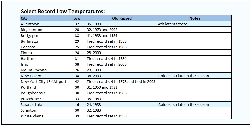
Some of this morning’s records:
-
Numerous records have been set or tied, including Allentown, Bridgeport, Islip (tied), New Haven, and White Plains (tied).
-
Tonight will be an unseasonably cool night. Areas well to the north and west of New York City could even experience some light frost. In the City and nearby areas, readings will bottom out in the lower and middle 40s before rising to the lower 60s. A few locations including Bridgeport and White Plains could approach or set new daily record low readings. Records include: Bridgeport: 41°, 1983 and 1984 Islip: 38°, 2003 New Haven: 36°, 2003 Newark: 43°, 1955, 1983 and 2003 Poughkeepsie: 30°, 1983 White Plains: 39°, 1983 Readings will warm during the weekend, but some rain is possible. Some of the guidance suggests that temperatures could return to the 80s to close the month. Typically, a very warm April is followed by a somewhat cooler than normal May in the Middle Atlantic region. Nevertheless, the guidance has persistently suggested that the month will end with a somewhat warmer than normal average. The ENSO Region 1+2 anomaly was +2.4°C and the Region 3.4 anomaly was +0.5°C for the week centered around May 10. For the past six weeks, the ENSO Region 1+2 anomaly has averaged +2.57°C and the ENSO Region 3.4 anomaly has averaged +0.28°C. Neutral ENSO conditions will likely prevail through at least mid-spring. El Niño conditions will very likely develop during the summer. The SOI was -11.40 today. The preliminary Arctic Oscillation (AO) was +1.964 today. On May 15 the MJO was in Phase 6 at an amplitude of 1.462 (RMM). The May 14-adjusted amplitude was 1.181 (RMM). Based on sensitivity analysis applied to the latest guidance, there is an implied 54% probability that New York City will have a warmer than normal May (1991-2020 normal). May will likely finish with a mean temperature near 63.4° (0.2° above normal).
-
A cooler air mass is now moving into the region. Fair but unseasonably cool conditions will prevail through the remainder of the week. Readings will warm during the weekend, but some rain is possible. Some of the guidance suggests that temperatures could return to the 80s to close the month. Typically, a very warm April is followed by a somewhat cooler than normal May in the Middle Atlantic region. Nevertheless, the guidance has persistently suggested that the month will end with a somewhat warmer than normal average. The ENSO Region 1+2 anomaly was +2.4°C and the Region 3.4 anomaly was +0.5°C for the week centered around May 10. For the past six weeks, the ENSO Region 1+2 anomaly has averaged +2.57°C and the ENSO Region 3.4 anomaly has averaged +0.28°C. Neutral ENSO conditions will likely prevail through at least mid-spring. El Niño conditions will very likely develop during the summer. The SOI was -20.05 today. The preliminary Arctic Oscillation (AO) was +1.646 today. On May 14 the MJO was in Phase 6 at an amplitude of 1.188 (RMM). The May 13-adjusted amplitude was 1.206 (RMM). Based on sensitivity analysis applied to the latest guidance, there is an implied 55% probability that New York City will have a warmer than normal May (1991-2020 normal). May will likely finish with a mean temperature near 63.4° (0.2° above normal).
-
After a comfortable night, tomorrow will be partly cloudy and warm. Temperatures will top out in the upper 70s and lower 80s. Noticeably cooler air will arrive tomorrow night. Today was another day of record heat in the Pacific Northwest. Records included: Bellingham, WA: 86° (old record: 80°, 2014) Olympia: 92° (old record: 85°, 2007) Port Angeles: 86° (old record: 75°, 2014) ***New May record*** Quillayute, WA: 86° (old record: 85°, 2006) Seattle: 88° (old record: 85°, 2007) Shelton, WA: 90° (old record: 88°, 2006) Portland reached 90° or above for a record 4th day in May. The 4-day heatwave was the earliest 4-day heatwave on record. The old record was set during June 4-7, 2003. Meanwhile, even as the heat slowly abates in the Pacific Northwest, readings will remain much above normal through much of the week. The generally above normal temperatures will continue through Tuesday. Afterward, a cool front will bring somewhat cooler than normal readings to the region. Readings will likely average near or just below normal through the remainder of the week. Typically, a very warm April is followed by a somewhat cooler than normal May in the Middle Atlantic region. Whether that will be the case this year remains to be seen. For now, the outcome is far too close to call with the sensitivity analysis showing a almost a "coin toss" outcome. However, some of the more recent guidance has begun to tilt toward a warmer outcome. Uncertainty persists for second half of the month. The ENSO Region 1+2 anomaly was +2.4°C and the Region 3.4 anomaly was +0.5°C for the week centered around May 10. For the past six weeks, the ENSO Region 1+2 anomaly has averaged +2.57°C and the ENSO Region 3.4 anomaly has averaged +0.28°C. Neutral ENSO conditions will likely prevail through at least mid-spring. El Niño conditions will very likely develop during the summer. The SOI was -12.47 today. The preliminary Arctic Oscillation (AO) was +1.925 today. On May 13 the MJO was in Phase 6 at an amplitude of 1.205 (RMM). The May 12-adjusted amplitude was 1.088 (RMM). Based on sensitivity analysis applied to the latest guidance, there is an implied 52% probability that New York City will have a warmer than normal May (1991-2020 normal). May will likely finish with a mean temperature near 63.3° (0.1° above normal).
-
Under brilliant sunshine, the temperature rose into the lower and middle 70s across the region today. Tomorrow will see somewhat warmer readings. Meanwhile, the Pacific Northwest heat dome continues to bring record heat to that region. Daily records include: Astoria, OR: 91° (old record: 87°, 2014) ***Tied first-half May record*** Brookings, OR: 88° (old record: 74°, 1922) Hoquiam, WA: 89° (old record: 84°, 2014) ***Tied May record*** North Bend, OR: 95° (old record: 82°, 2014) Olympia: 89° (tied record set in 1973) Salem, OR: 93° (old record: 92°, 1939) Quillayute, WA: 91° (old record: 83°, 2014) Earlier today, Portland recorded a daily low temperature of 62°. That tied May 14, 1997 for the earliest 60° or above minimum temperature. That also tied the monthly record of 62°, which was set on May 28, 1983 and tied on May 31, 1986 and May 17, 2008. Portland also recorded only its second May heatwave on record. Quillayute's 2 consecutive 90° or above temperatures was the earliest such stretch on record. The previous record was set during June 25-26, 2006. The two 90° days also set a new record for most such days in May. In British Columbia, Cultus Lake and Squamish reached 95°, setting daily records. Near record and record heat will continue in parts of the Pacific Northwest through tomorrow. Even as the heat slowly abates afterward, readings will remain much above normal through much of the week. The generally above normal temperatures will continue through Tuesday. Afterward, a cool front will bring somewhat cooler than normal readings to the region. Readings will likely average near or just below normal through the remainder of the week. Typically, a very warm April is followed by a somewhat cooler than normal May in the Middle Atlantic region. Whether that will be the case this year remains to be seen. For now, the outcome is far too close to call with the sensitivity analysis showing a almost a "coin toss" outcome. However, some of the more recent guidance has begun to tilt toward a warmer outcome. Uncertainty persists for second half of the month. The ENSO Region 1+2 anomaly was +2.7°C and the Region 3.4 anomaly was +0.4°C for the week centered around May 3. For the past six weeks, the ENSO Region 1+2 anomaly has averaged +2.48°C and the ENSO Region 3.4 anomaly has averaged +0.20°C. Neutral ENSO conditions will likely prevail through at least mid-spring. El Niño conditions will very likely develop during the summer. The SOI was -15.99 today. The preliminary Arctic Oscillation (AO) was +1.918 today. On May 12 the MJO was in Phase 6 at an amplitude of 1.081 (RMM). The May 11-adjusted amplitude was 1.341 (RMM). Based on sensitivity analysis applied to the latest guidance, there is an implied 54% probability that New York City will have a warmer than normal May (1991-2020 normal). May will likely finish with a mean temperature near 63.4° (0.2° above normal).
-
Tomorrow will be partly sunny and somewhat cooler. Temperatures will likely top out in the lower and middle 70s. As of 3 pm PDT, Portland had reached 92°, which tied the daily record set in 1973. Portland's preliminary low temperature of 57° was positioned to break the existing record high minimum reading of 56°, which was set in 1959 and tied in 1981). Seattle and Olympia were just 1° below their daily records. Near record and record heat will continue in the Pacific Northwest. Even as the heat slowly abates early next week, readings will remain much above normal for the season through much of the week. The generally above normal temperatures will continue through Tuesday. Afterward, a cool front will bring somewhat cooler than normal readings to the region. Readings will likely average near or just below normal through the remainder of the week. Typically, a very warm April is followed by a somewhat cooler than normal May in the Middle Atlantic region. Whether that will be the case this year remains to be seen. For now, the outcome is far too close to call with the sensitivity analysis showing a almost a "coin toss" outcome. However, some of the more recent guidance has begun to tilt toward a warmer outcome. Uncertainty persists for second half of the month. The ENSO Region 1+2 anomaly was +2.7°C and the Region 3.4 anomaly was +0.4°C for the week centered around May 3. For the past six weeks, the ENSO Region 1+2 anomaly has averaged +2.48°C and the ENSO Region 3.4 anomaly has averaged +0.20°C. Neutral ENSO conditions will likely prevail through at least mid-spring. El Niño conditions will very likely develop during the summer. The SOI was -28.48 today. The preliminary Arctic Oscillation (AO) was +1.401 today. On May 11 the MJO was in Phase 6 at an amplitude of 1.332 (RMM). The May 10-adjusted amplitude was 1.542 (RMM). Based on sensitivity analysis applied to the latest guidance, there is an implied 54% probability that New York City will have a warmer than normal May (1991-2020 normal). May will likely finish with a mean temperature near 63.4° (0.2° above normal).
-
Tomorrow will be fair and still warm. Highs will generally reach the upper 70s. A few locations could reach or exceed 80°. There could be a passing shower. Temperatures will remain generally above normal through the coming weekend and perhaps longer. The duration and magnitude of this overall warm period could determine the overall monthly temperature anomaly. The Pacific Northwest will likely see near record to record heat develop in parts of Oregon, Washington, and British Columbia this weekend. Typically, a very warm April is followed by a somewhat cooler than normal May in the Middle Atlantic region. Whether that will be the case this year remains to be seen. For now, the outcome is far too close to call with the sensitivity analysis showing a almost a "coin toss" outcome. However, some of the more recent guidance has begun to tilt toward a warmer outcome. Uncertainty remains high for second half of the month. The ENSO Region 1+2 anomaly was +2.7°C and the Region 3.4 anomaly was +0.4°C for the week centered around May 3. For the past six weeks, the ENSO Region 1+2 anomaly has averaged +2.48°C and the ENSO Region 3.4 anomaly has averaged +0.20°C. Neutral ENSO conditions will likely prevail through at least mid-spring. El Niño conditions will very likely develop during the summer. The SOI was -31.31 today. The preliminary Arctic Oscillation (AO) was +0.973 today. On May 10 the MJO was in Phase 5 at an amplitude of 1.542 (RMM). The May 9-adjusted amplitude was 1.666 (RMM). Based on sensitivity analysis applied to the latest guidance, there is an implied 52% probability that New York City will have a warmer than normal May (1991-2020 normal). May will likely finish with a mean temperature near 63.3° (0.1° above normal).
-
Tomorrow will be fair and very warm. Highs will generally reach the lower and middle 80s. A few locations could see the mercury rise to the upper 80s. Temperatures will remain generally above normal through the coming weekend and perhaps longer. The duration and magnitude of this overall warm period could determine the overall monthly temperature anomaly. The Pacific Northwest could see near record to record heat develop in parts of Oregon, Washington, and British Columbia during the weekend. Typically, a very warm April is followed by a somewhat cooler than normal May in the Middle Atlantic region. Whether that will be the case this year remains to be seen. For now, the outcome is far too close to call with the sensitivity analysis showing a almost a "coin toss" outcome. However, some of the more recent guidance has begun to tilt toward a warmer outcome. Uncertainty remains high for second half of the month. The ENSO Region 1+2 anomaly was +2.7°C and the Region 3.4 anomaly was +0.4°C for the week centered around May 3. For the past six weeks, the ENSO Region 1+2 anomaly has averaged +2.48°C and the ENSO Region 3.4 anomaly has averaged +0.20°C. Neutral ENSO conditions will likely prevail through at least mid-spring. El Niño conditions will very likely develop during the summer. The SOI was -26.56 today. The preliminary Arctic Oscillation (AO) was +0.746 today. On May 9 the MJO was in Phase 5 at an amplitude of 1.659 (RMM). The May 8-adjusted amplitude was 1.783 (RMM). Based on sensitivity analysis applied to the latest guidance, there is an implied 54% probability that New York City will have a warmer than normal May (1991-2020 normal). May will likely finish with a mean temperature near 63.4° (0.2° above normal).
-
Under sunny skies, tomorrow will see temperatures rise into the upper 70s and lower 80s. Temperatures will remain generally above normal through the coming weekend and perhaps longer. The duration and magnitude of this overall warm period could determine the overall monthly temperature anomaly. The Pacific Northwest could see near record to record heat develop in parts of Oregon, Washington, and British Columbia during the weekend. Typically, a very warm April is followed by a somewhat cooler than normal May in the Middle Atlantic region. Whether that will be the case this year remains to be seen. For now, the outcome is far too close to call with the sensitivity analysis showing a almost a "coin toss" outcome. However, some of the more recent guidance has begun to tilt toward a warmer outcome. Uncertainty remains high for second half of the month. The ENSO Region 1+2 anomaly was +2.7°C and the Region 3.4 anomaly was +0.4°C for the week centered around May 3. For the past six weeks, the ENSO Region 1+2 anomaly has averaged +2.48°C and the ENSO Region 3.4 anomaly has averaged +0.20°C. Neutral ENSO conditions will likely prevail through at least mid-spring. El Niño conditions will very likely develop during the summer. The SOI was -16.68 today. The preliminary Arctic Oscillation (AO) was +1.042 today. On May 8 the MJO was in Phase 5 at an amplitude of 1.778 (RMM). The May 7-adjusted amplitude was 1.955 (RMM). Based on sensitivity analysis applied to the latest guidance, there is an implied 53% probability that New York City will have a warmer than normal May (1991-2020 normal). May will likely finish with a mean temperature near 63.4° (0.2° above normal).
-
Milder air will begin to return tomorrow. Temperatures will remain generally above normal through the coming weekend and perhaps longer. The duration and magnitude of this overall warm period could determine the overall monthly temperature anomaly. The Pacific Northwest could see near record to record heat develop in parts of Oregon, Washington, and British Columbia during the weekend. Typically, a very warm April is followed by a somewhat cooler than normal May in the Middle Atlantic region. Whether that will be the case this year remains to be seen. For now, the outcome is far too close to call with the sensitivity analysis showing a almost a "coin toss" outcome. However, some of the more recent guidance has begun to tilt toward a warmer outcome. Uncertainty remains high for second half of the month. The ENSO Region 1+2 anomaly was +2.7°C and the Region 3.4 anomaly was +0.4°C for the week centered around May 3. For the past six weeks, the ENSO Region 1+2 anomaly has averaged +2.48°C and the ENSO Region 3.4 anomaly has averaged +0.20°C. Neutral ENSO conditions will likely prevail through at least mid-spring. El Niño conditions will very likely develop during the summer. The SOI was -10.48 today. The preliminary Arctic Oscillation (AO) was +1.122 today. On May 7 the MJO was in Phase 5 at an amplitude of 1.953 (RMM). The May 6-adjusted amplitude was 2.209 (RMM). Based on sensitivity analysis applied to the latest guidance, there is an implied 51% probability that New York City will have a warmer than normal May (1991-2020 normal). May will likely finish with a mean temperature near 63.3° (0.1° above normal).
-
Tomorrow and Wednesday will be somewhat cooler days. However, temperatures will remain generally above normal through the coming weekend and perhaps longer. The duration and magnitude of this overall warm period could determine the overall monthly temperature anomaly. The Pacific Northwest could see near record to record heat develop in parts of Oregon, Washington, and British Columbia during the weekend. Typically, a very warm April is followed by a somewhat cooler than normal May in the Middle Atlantic region. Whether that will be the case this year remains to be seen. For now, the outcome is far too close to call with the sensitivity analysis showing a "coin toss" outcome. The ENSO Region 1+2 anomaly was +2.7°C and the Region 3.4 anomaly was +0.4°C for the week centered around May 3. For the past six weeks, the ENSO Region 1+2 anomaly has averaged +2.48°C and the ENSO Region 3.4 anomaly has averaged +0.20°C. Neutral ENSO conditions will likely prevail through at least mid-spring. El Niño conditions will very likely develop during the summer. The SOI was +0.25 today. The preliminary Arctic Oscillation (AO) was +0.703 today. On May 6 the MJO was in Phase 4 at an amplitude of 2.212 (RMM). The May 5-adjusted amplitude was 2.554 (RMM). Based on sensitivity analysis applied to the latest guidance, there is an implied 50% probability that New York City will have a cooler than normal May (1991-2020 normal). May will likely finish with a mean temperature near 63.2° (normal normal).
-
Thank you, Rjay.
-
Tomorrow will be another fair and warm day. Highs will climb into the middle and upper 70s. A few 80° temperatures are possible. Readings will remain generally above normal through next weekend as the ongoing blocking dissipates and warmer air comes eastward. Tuesday and Wednesday could be somewhat cooler as a small area of cooler air passes through the region. The duration and magnitude of the overall warm period could determine the overall monthly temperature anomaly. Typically, a very warm April is followed by a somewhat cooler than normal May in the Middle Atlantic region. Whether that will be the case this year remains to be seen. For now, the outcome is far too close to call. The ENSO Region 1+2 anomaly was +2.4°C and the Region 3.4 anomaly was +0.4°C for the week centered around April 26. For the past six weeks, the ENSO Region 1+2 anomaly has averaged +2.37°C and the ENSO Region 3.4 anomaly has averaged +0.13°C. Neutral ENSO conditions will likely prevail through at least mid-spring. El Niño conditions will very likely develop during the summer. The SOI was +11.13 today. The preliminary Arctic Oscillation (AO) was +0.351 today. On May 5 the MJO was in Phase 4 at an amplitude of 2.555 (RMM). The May 4-adjusted amplitude was 2.463 (RMM). Based on sensitivity analysis applied to the latest guidance, there is an implied 50% probability that New York City will have a cooler than normal May (1991-2020 normal). May will likely finish with a mean temperature near 63.2° (normal).
-
It was a sun-filled day at the New York Botanical Garden with a high of 78°. The first roses and peonies are now starting to blossom. Azaleas and tulips are generally past their peak.


-
A warming trend is now well underway. The sun-filled weekend will conclude tomorrow with readings topping out in the lower and middle 70s lies ahead. Some areas could see the mercury rise into the upper 70s. Readings will remain generally above normal through next weekend as the ongoing blocking dissipates and warmer air comes eastward. Tuesday and Wednesday could be somewhat cooler as a small area of cooler air passes through the region. The duration and magnitude of the overall warm period could determine the overall monthly temperature anomaly. Typically, a very warm April is followed by a somewhat cooler than normal May in the Middle Atlantic region. Whether that will be the case this year remains to be seen. The ENSO Region 1+2 anomaly was +2.4°C and the Region 3.4 anomaly was +0.4°C for the week centered around April 26. For the past six weeks, the ENSO Region 1+2 anomaly has averaged +2.37°C and the ENSO Region 3.4 anomaly has averaged +0.13°C. Neutral ENSO conditions will likely prevail through at least mid-spring. El Niño conditions will very likely develop during the summer. The SOI was +16.33 today. The preliminary Arctic Oscillation (AO) was +0.001 today. On May 4 the MJO was in Phase 4 at an amplitude of 2.455 (RMM). The May 3-adjusted amplitude was 2.476 (RMM).
-
A warming trend is now getting underway. A glorious sun-filled weekend with readings in the upper 60s and lower 70s lies ahead. Readings will reach normal levels by Sunday and then go above normal early next week as the ongoing blocking regime fades and warmer air comes eastward. The duration and magnitude of this warm period could determine the overall monthly temperature anomaly. Typically, a very warm April is followed by a somewhat cooler than normal May in the Middle Atlantic region. Whether that will be the case this year remains to be seen. The ENSO Region 1+2 anomaly was +2.4°C and the Region 3.4 anomaly was +0.4°C for the week centered around April 26. For the past six weeks, the ENSO Region 1+2 anomaly has averaged +2.37°C and the ENSO Region 3.4 anomaly has averaged +0.13°C. Neutral ENSO conditions will likely prevail through at least mid-spring. El Niño conditions will very likely develop during the summer. The SOI was +10.67 today. The preliminary Arctic Oscillation (AO) was -0.156 today. On May 3 the MJO was in Phase 4 at an amplitude of 2.471 (RMM). The May 2-adjusted amplitude was 2.501 (RMM).
-
Temperatures rose mainly into the middle 50s. Tomorrow will be somewhat warmer, as temperatures begin to moderate. Readings will reach normal levels by Sunday and then go above normal early next week as the ongoing blocking regime fades and warmer air comes eastward. The duration and magnitude of this warm period could determine the overall monthly temperature anomaly. Typically, a very warm April is followed by a somewhat cooler than normal May in the Middle Atlantic region. Whether that will be the case this year remains to be seen. The ENSO Region 1+2 anomaly was +2.4°C and the Region 3.4 anomaly was +0.4°C for the week centered around April 26. For the past six weeks, the ENSO Region 1+2 anomaly has averaged +2.37°C and the ENSO Region 3.4 anomaly has averaged +0.13°C. Neutral ENSO conditions will likely prevail through at least mid-spring. El Niño conditions will very likely develop during the summer. The SOI was -9.48 today. The preliminary Arctic Oscillation (AO) was -0.608 today. On May 2 the MJO was in Phase 4 at an amplitude of 2.497 (RMM). The May 1-adjusted amplitude was 2.369 (RMM).
-
Tomorrow and Friday will remain unseasonably cool. However, temperatures will begin to moderate. Readings will reach normal levels by Sunday and then go above normal early next week. The duration and magnitude of this warm period could determine the overall monthly temperature anomaly. Typically, a very warm April is followed by a somewhat cooler than normal May in the Middle Atlantic region. Whether that will be the case this year remains to be seen. The ENSO Region 1+2 anomaly was +2.4°C and the Region 3.4 anomaly was +0.4°C for the week centered around April 26. For the past six weeks, the ENSO Region 1+2 anomaly has averaged +2.37°C and the ENSO Region 3.4 anomaly has averaged +0.13°C. Neutral ENSO conditions will likely prevail through at least mid-spring. El Niño conditions will very likely develop during the summer. The SOI was +5.23 today. The preliminary Arctic Oscillation (AO) was -1.102 today. On May 1 the MJO was in Phase 4 at an amplitude of 2.497 (RMM). The April 30-adjusted amplitude was 2.369 (RMM).
-
Clouds, showers, and occasional sunshine accompanied by very cool readings ruled the day. The cool unsettled weather will continue through Friday. Afterward, temperatures will trend toward normal and then above normal during the second week of May. The duration and magnitude of this warm period could determine the overall monthly temperature anomaly. Typically, a very warm April is followed by a somewhat cooler than normal May in the Middle Atlantic region. Whether that will be the case this year remains to be seen. The ENSO Region 1+2 anomaly was +2.4°C and the Region 3.4 anomaly was +0.4°C for the week centered around April 26. For the past six weeks, the ENSO Region 1+2 anomaly has averaged +2.37°C and the ENSO Region 3.4 anomaly has averaged +0.13°C. Neutral ENSO conditions will likely prevail through at least mid-spring. El Niño conditions will very likely develop during the summer. The SOI was +5.23 today. The preliminary Arctic Oscillation (AO) was -1.218 today. On April 30 the MJO was in Phase 4 at an amplitude of 1.946 (RMM). The April 29-adjusted amplitude was 1.535 (RMM).
-
It is. The "normal" temperature has risen about 1° from 1961-1990 to 1991-2020. The anomalies are measured against an elevated and still warming baseline.