donsutherland1
-
Posts
23,765 -
Joined
Content Type
Profiles
Blogs
Forums
American Weather
Media Demo
Store
Gallery
Everything posted by donsutherland1
-
Temperatures will be cooler tomorrow before rebounding strongly on Tuesday. That patter will likely repeat itself for Wednesday and Thursday. Afterward, a strong cold front, perhaps preceded by some showers or a period of rain, will bring a period of colder weather to the region. Overall, the first 10-14 days of November remains on track for a cold anomaly. The long-range guidance is continuing to move into consensus that the second half of November could be generally warmer than normal. Whether that will set the stage for a mild Thanksgiving week remains to be seen. The ENSO Region 1+2 anomaly was +2.6°C and the Region 3.4 anomaly was +1.6°C for the week centered around October 25. For the past six weeks, the ENSO Region 1+2 anomaly has averaged +2.47°C and the ENSO Region 3.4 anomaly has averaged +1.57°C. El Niño conditions will likely continue to strengthen into the fall with the current East-based event transitioning to a basinwide El Niño for the upcoming winter. That transition is currently underway. The SOI was -9.23 today. The preliminary Arctic Oscillation (AO) was -0.291 today. On November 1 the MJO was in Phase 1 at an amplitude of 0.543 (RMM). The October 31-adjusted amplitude was 0.714 (RMM).
-
The early November chill will continue to moderate this weekend. Temperatures will likely top out in the 60s tomorrow. Another cold shot could arrive late next week, perhaps preceded by some showers or a period of rain. Overall, the first 10-14 days of November remains on track for a cold anomaly. The ENSO Region 1+2 anomaly was +2.6°C and the Region 3.4 anomaly was +1.6°C for the week centered around October 25. For the past six weeks, the ENSO Region 1+2 anomaly has averaged +2.47°C and the ENSO Region 3.4 anomaly has averaged +1.57°C. El Niño conditions will likely continue to strengthen into the fall with the current East-based event transitioning to a basinwide El Niño for the upcoming winter. That transition is currently underway. The SOI was +1.46 today. The preliminary Arctic Oscillation (AO) was -0.934 today. On November 1 the MJO was not available. The October 31-adjusted amplitude was 0.714 (RMM).
-
The chill will continue to moderate this weekend. Moreover, a dry weekend appears to be in store. Nevertheless, the first 10-14 days of November remains on track for a cold anomaly. The ENSO Region 1+2 anomaly was +2.6°C and the Region 3.4 anomaly was +1.6°C for the week centered around October 25. For the past six weeks, the ENSO Region 1+2 anomaly has averaged +2.47°C and the ENSO Region 3.4 anomaly has averaged +1.57°C. El Niño conditions will likely continue to strengthen into the fall with the current East-based event transitioning to a basinwide El Niño for the upcoming winter. That transition is currently underway. The SOI was +0.12 today. The preliminary Arctic Oscillation (AO) was -1.262 today. On October 31 the MJO was in Phase 1 at an amplitude of 0.714 (RMM). The October 30-adjusted amplitude was 0.940 (RMM).
-
This morning saw a widespread hard freeze across much of the region. Low temperatures included: Bridgeport: 30° Islip: 28° New Haven: 29° (tied record set in 1961 and tied in 1965) New York City: 35° Newark: 35° Philadelphia: 34° White Plains: 28° (tied record set in 2002) Elsewhere, record lows were recorded at Alexandria, LA (coldest low so early in the season), Danville, Lynchburg, and Macon, among other cities. Tonight will be fair and cold. Additional frost is likely outside New York City and Philadelphia. The chill will moderate by the weekend, but temperatures could average below normal through the first 10-14 days of November. The ENSO Region 1+2 anomaly was +2.6°C and the Region 3.4 anomaly was +1.6°C for the week centered around October 25. For the past six weeks, the ENSO Region 1+2 anomaly has averaged +2.47°C and the ENSO Region 3.4 anomaly has averaged +1.57°C. El Niño conditions will likely continue to strengthen into the fall with the current East-based event transitioning to a basinwide El Niño for the upcoming winter. That transition is currently underway. The SOI was -3.50 today. The preliminary Arctic Oscillation (AO) was -1.265 today. On October 30 the MJO was in Phase 8 at an amplitude of 0.940 (RMM). The October 29-adjusted amplitude was 0.997 (RMM).
-
Areas outside of New York City and Philadelphia will see widespread freezes tonight. The chill will moderate by the weekend, but temperatures could average below normal through the first 10-14 days of November. October is solidly on track to finish as a warmer than normal month. Since 1950, only a single El Niño event with a monthly ENSO R3.4 anomaly of +1.00°C or above was warmer than normal in New York City during October: 2015 (sample size: 6). If one lowers the ENSO R3.4 anomaly to +0.75°C or above, only two 2/12 (17%) of El Niño cases saw a warmer than normal October in New York City: 1963 and 2015. Both years saw warm Octobers followed by warm Novembers. The ENSO Region 1+2 anomaly was +2.6°C and the Region 3.4 anomaly was +1.6°C for the week centered around October 25. For the past six weeks, the ENSO Region 1+2 anomaly has averaged +2.47°C and the ENSO Region 3.4 anomaly has averaged +1.57°C. El Niño conditions will likely continue to strengthen into the fall with the current East-based event transitioning to a basinwide El Niño for the upcoming winter. That transition is currently underway. The SOI was +0.38 today. The preliminary Arctic Oscillation (AO) was -0.802 today. On October 29 the MJO was in Phase 8 at an amplitude of 0.997 (RMM). The October 28-adjusted amplitude was 1.083 (RMM).
-
A warm October is concluding with chilly readings. In New York City,Ocrober had a mean temperature of 60.5°. That was 2.6° warmer than normal. Overnight, an offshore storm will bring some showers and periods of light rain to the region. November will begin on a cold note. Areas outside of New York City and Philadelphia will see widespread freezes tomorrow night. The chill will moderate by the weekend, but temperatures could average below normal through the first 10-14 days of November. October is solidly on track to finish as a warmer than normal month. Since 1950, only a single El Niño event with a monthly ENSO R3.4 anomaly of +1.00°C or above was warmer than normal in New York City during October: 2015 (sample size: 6). If one lowers the ENSO R3.4 anomaly to +0.75°C or above, only two 2/12 (17%) of El Niño cases saw a warmer than normal October in New York City: 1963 and 2015. Both years saw warm Octobers followed by warm Novembers. The ENSO Region 1+2 anomaly was +2.6°C and the Region 3.4 anomaly was +1.6°C for the week centered around October 25. For the past six weeks, the ENSO Region 1+2 anomaly has averaged +2.47°C and the ENSO Region 3.4 anomaly has averaged +1.57°C. El Niño conditions will likely continue to strengthen into the fall with the current East-based event transitioning to a basinwide El Niño for the upcoming winter. That transition is currently underway. The SOI was +7.67 today. The preliminary Arctic Oscillation (AO) was -0.531 today. On October 28 the MJO was in Phase 8 at an amplitude of 1.083 (RMM). The October 27-adjusted amplitude was 1.326 (RMM).
-
DCA_NYC_BOS__ ORD_ATL_IAH__ DEN_ PHX_ SEA 0.0 -0.3 -0.6 0.2 0.0 0.2 3.0 2.5 3.6
-
Much colder air is now pouring into the region. Following the frontal passage, the coldest air of the season will cover the region to end October and begin November. The chill will moderate by next weekend. October is solidly on track to finish as a warmer than normal month. Since 1950, only a single El Niño event with a monthly ENSO R3.4 anomaly of +1.00°C or above was warmer than normal in New York City during October: 2015 (sample size: 6). If one lowers the ENSO R3.4 anomaly to +0.75°C or above, only two 2/12 (17%) of El Niño cases saw a warmer than normal October in New York City: 1963 and 2015. Both years saw warm Octobers followed by warm Novembers. The ENSO Region 1+2 anomaly was +2.6°C and the Region 3.4 anomaly was +1.6°C for the week centered around October 25. For the past six weeks, the ENSO Region 1+2 anomaly has averaged +2.47°C and the ENSO Region 3.4 anomaly has averaged +1.57°C. El Niño conditions will likely continue to strengthen into the fall with the current East-based event transitioning to a basinwide El Niño for the upcoming winter. That transition is currently underway. The SOI was +6.96 today. The preliminary Arctic Oscillation (AO) was -0.552 today. On October 27 the MJO was in Phase 7 at an amplitude of 1.120 (RMM). The October 26-adjusted amplitude was 1.239 (RMM). Based on sensitivity analysis applied to the latest guidance, there is an implied near 100% probability that New York City will have a warmer than normal October (1991-2020 normal). October will likely finish with a mean temperature near 60.4° (2.5° above normal).
-
Light rain and drizzle will continue into the night. Across northern and western Maine, an appreciable snowfall is likely. Parts of that region could see 3"-6" of snow with locally higher amounts. Tomorrow will become milder with temperatures reaching the lower 60s in the northern Mid-Atlantic region and approaching or reaching 70° or above from southern New Jersey southward. However, much colder air will pour into the region tomorrow night. Afterward, the coldest air of the season will cover the region to end October and begin November. The chill will moderate by next weekend. October is solidly on track to finish as a warmer than normal month. Since 1950, only a single El Niño event with a monthly ENSO R3.4 anomaly of +1.00°C or above was warmer than normal in New York City during October: 2015 (sample size: 6). If one lowers the ENSO R3.4 anomaly to +0.75°C or above, only two 2/12 (17%) of El Niño cases saw a warmer than normal October in New York City: 1963 and 2015. Both years saw warm Octobers followed by warm Novembers. The ENSO Region 1+2 anomaly was +2.3°C and the Region 3.4 anomaly was +1.6°C for the week centered around October 18. For the past six weeks, the ENSO Region 1+2 anomaly has averaged +2.57°C and the ENSO Region 3.4 anomaly has averaged +1.57°C. El Niño conditions will likely continue to strengthen into the fall with the current East-based event transitioning to a basinwide El Niño for the upcoming winter. That transition is currently underway. The SOI was -3.29 today. The preliminary Arctic Oscillation (AO) was -0.943 today. On October 26 the MJO was in Phase 7 at an amplitude of 1.239 (RMM). The October 25-adjusted amplitude was 1.256 (RMM). Based on sensitivity analysis applied to the latest guidance, there is an implied near 100% probability that New York City will have a warmer than normal October (1991-2020 normal). October will likely finish with a mean temperature near 60.4° (2.5° above normal).
-
One-quarter mile visibility on October 29, 2011:
-
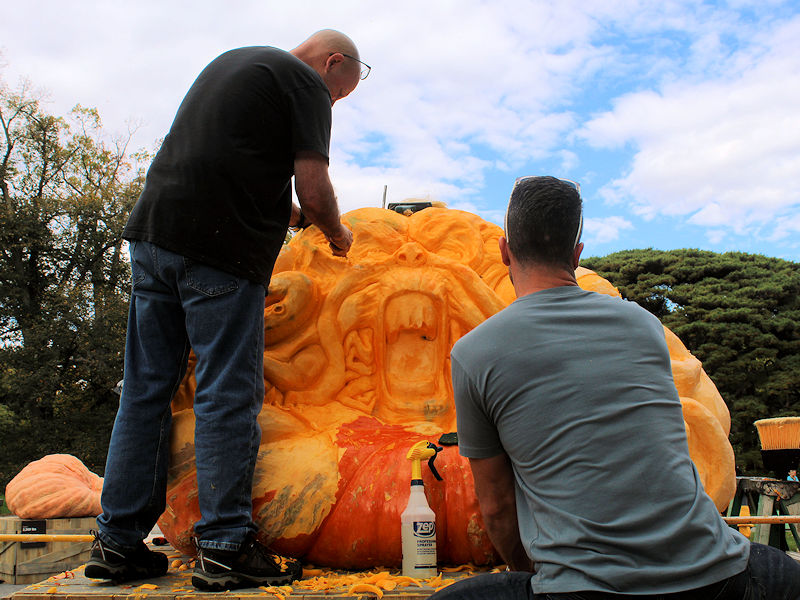
Under mainly sunny skies, the temperature surged to near record and record levels across the New York City area and adjacent suburbs. At the New York Botanical Garden, the 2,245.5 lb (1,018.5 kg) pumpkin was being carved. The chrysanthemum show was in full swing.


-
The late-season episode of summer weather will come to an abrupt end tomorrow. Today, readings soared to near record and record highs in much of the East. High temperatures included: Atlantic City: 82° (old record: 81°, 1984) Baltimore: 85° Bangor: 79° (old record: 76°, 1947 and 1989) ***Highest temperature so late in the season*** Boston: 81° (tied record set in 1919) Bridgeport: 75° (old record: 72°, 1964, 1971, and 2010) Charlottesville, VA: 89° (old record: 88°, 1919) ***Highest temperature so late in the season*** Concord: 80° (old record: 78°, 1947) Hartford: 84° (old record: 81°, 1919) ***Highest temperature so late in the season*** Islip: 83° (old record: 75°, 1971) ***Highest temperature so late in the season*** Manchester, NH: 82° (old record: 73°, 1947, 1966, and 2010) ***Highest temperature so late in the season*** New Haven: 79° (old record: 73°, 1977) New York City-Central Park: 80° New York City-JFK Airport: 81° (old record: 76°, 2010) New York City-LaGuardia Airport: 82° (old record: 80°, 1984) Newark: 84° (old record: 82°, 1984) Philadelphia: 83° Portland, ME: 80° (old record: 78°, 1947) Providence: 82° (old record: 80°, 1919) Richmond: 86° Washington, DC: 86° White Plains: 81° (old record: 80°, 1964) Wilmington, DE: 83° (tied record set in 1919) Worcester: 78° A weak cold front will bring showers and periods of rain, along with cooler weather tomorrow. Temperatures will rise no higher than the upper 50s and perhaps lower 60s. Monday could be slightly milder, but much colder air will overspread the region late Monday or Monday night. Afterward, the coldest air of the season will cover the region to end October and begin November. October is solidly on track to finish as a warmer than normal month. Since 1950, only a single El Niño event with a monthly ENSO R3.4 anomaly of +1.00°C or above was warmer than normal in New York City during October: 2015 (sample size: 6). If one lowers the ENSO R3.4 anomaly to +0.75°C or above, only two 2/12 (17%) of El Niño cases saw a warmer than normal October in New York City: 1963 and 2015. Both years saw warm Octobers followed by warm Novembers. The ENSO Region 1+2 anomaly was +2.3°C and the Region 3.4 anomaly was +1.6°C for the week centered around October 18. For the past six weeks, the ENSO Region 1+2 anomaly has averaged +2.57°C and the ENSO Region 3.4 anomaly has averaged +1.57°C. El Niño conditions will likely continue to strengthen into the fall with the current East-based event transitioning to a basinwide El Niño for the upcoming winter. That transition is currently underway. The SOI was -0.58 today. The preliminary Arctic Oscillation (AO) was -0.611 today. On October 25 the MJO was in Phase 7 at an amplitude of 1.256 (RMM). The October 24-adjusted amplitude was 1.121 (RMM). Based on sensitivity analysis applied to the latest guidance, there is an implied near 100% probability that New York City will have a warmer than normal October (1991-2020 normal). October will likely finish with a mean temperature near 60.2° (2.3° above normal).
-
Islip has reached 81. That is the highest temperature so late in the season. The previous latest 81 or above occurred on October 19, 2016 (84).
-
Islip has reached 77. That breaks the daily record of 75 that was set in 1971.
-
Occasional Thoughts on Climate Change
donsutherland1 replied to donsutherland1's topic in Climate Change
For those who are interested, Joe Bastardi received his very first fact check. AFP fact checked his claim that submarine volcanoes are driving climate change. The fact check can be found here: https://factcheck.afp.com/doc.afp.com.33YL6RV -
Despite a cloudy start, temperatures again reach much above normal levels today. Highs included: Albany: 80° (old record: 79°, 1963) Baltimore: 82° (tied record set in 1963) Binghamton: 77° (old record: 73°, 1991) Boston: 79° Islip: 74° New York City: 74° Newark: 77° Washington, DC: 82° Tomorrow will see temperature peak. Readings will likely reach the upper 70s and lower 80s into southern and central New England. A weak cold front will bring showers and cooler weather on Sunday. Monday will remain fairly mild and perhaps somewhat warmer than Sunday, but much colder air will overspread the region late Monday or Monday night. Afterward, the coldest air of the season will cover the region to end October and begin November. October is solidly on track to finish as a warmer than normal month. Since 1950, only a single El Niño event with a monthly ENSO R3.4 anomaly of +1.00°C or above was warmer than normal in New York City during October: 2015 (sample size: 6). If one lowers the ENSO R3.4 anomaly to +0.75°C or above, only two 2/12 (17%) of El Niño cases saw a warmer than normal October in New York City: 1963 and 2015. Both years saw warm Octobers followed by warm Novembers. The ENSO Region 1+2 anomaly was +2.3°C and the Region 3.4 anomaly was +1.6°C for the week centered around October 18. For the past six weeks, the ENSO Region 1+2 anomaly has averaged +2.57°C and the ENSO Region 3.4 anomaly has averaged +1.57°C. El Niño conditions will likely continue to strengthen into the fall with the current East-based event transitioning to a basinwide El Niño for the upcoming winter. That transition is currently underway. The SOI was -5.22 today. The preliminary Arctic Oscillation (AO) was -0.425 today. On October 24 the MJO was in Phase 7 at an amplitude of 1.121 (RMM). The October 23-adjusted amplitude was 1.009 (RMM). Based on sensitivity analysis applied to the latest guidance, there is an implied near 100% probability that New York City will have a warmer than normal October (1991-2020 normal). October will likely finish with a mean temperature near 60.3° (2.4° above normal).
-
Thank you, Maureen.
-
Some sunrise photos. Lots of clouds but warm.


-
Bright sunshine sent temperatures soaring to near record and record highs across the region. High temperatures included: Albany: 77° Atlantic City: 80° (tied record set in 1963) Baltimore: 83° (old record: 81°, 1978) Boston: 80° Bridgeport: 74° (tied record set in 1963) Hartford: 80° Islip: 76° (old record: 75°, 1971) New Haven: 74° (old record: 70°, 1948, 1963, and 2010) New York City-Central Park: 77° New York City-JFK Airport: 74° New York City-LaGuardia Airport: 80° (old record: 76°, 1947 and 1963) Newark: 82° (old record: 79°, 1963 and 1964) Philadelphia: 80° (old record: 78°, 1920) Poughkeepsie: 81° (tied record set in 1963) Providence: 77° Washington, DC: 78° Tomorrow and Saturday will see a continuation of very warm weather. Readings will peak in the upper 70s and even lower 80s across parts of the region into southern New England. A weak cold front will bring showers and somewhat cooler weather on Sunday. Monday will remain fairly mild, but much colder air will overspread the region late Monday or Monday night. Afterward, the coldest air of the season will cover the region to end October and begin November. October is solidly on track to finish as a warmer than normal month. Since 1950, only a single El Niño event with a monthly ENSO R3.4 anomaly of +1.00°C or above was warmer than normal in New York City during October: 2015 (sample size: 6). If one lowers the ENSO R3.4 anomaly to +0.75°C or above, only two 2/12 (17%) of El Niño cases saw a warmer than normal October in New York City: 1963 and 2015. Both years saw warm Octobers followed by warm Novembers. The ENSO Region 1+2 anomaly was +2.3°C and the Region 3.4 anomaly was +1.6°C for the week centered around October 18. For the past six weeks, the ENSO Region 1+2 anomaly has averaged +2.57°C and the ENSO Region 3.4 anomaly has averaged +1.57°C. El Niño conditions will likely continue to strengthen into the fall with the current East-based event transitioning to a basinwide El Niño for the upcoming winter. That transition is currently underway. The SOI was -3.16 today. The preliminary Arctic Oscillation (AO) was -0.191 today. On October 23 the MJO was in Phase 6 at an amplitude of 1.009 (RMM). The October 22-adjusted amplitude was 0.879 (RMM). Based on sensitivity analysis applied to the latest guidance, there is an implied near 100% probability that New York City will have a warmer than normal October (1991-2020 normal). October will likely finish with a mean temperature near 60.3° (2.4° above normal).
-
Occasional Thoughts on Climate Change
donsutherland1 replied to donsutherland1's topic in Climate Change
There is an effort to try to discount any link beween Otis' rapid intensification and climate change, even as the literature increasingly shows that the warming climate is leading to an increase in rapid intensification cases. Worse, the efforts are deceptive. Look more closely at the map. Notice the dates. The SSTAs are not from the time when Otis approached and made landfall (October 24-25), but from the August 26-September 1, 2023 period. Thus, the argument rests on obsolete information. It is not an evidence-based argument. It is misleading, as it implies that the data is from the relevant timeframe when, in fact, it is not.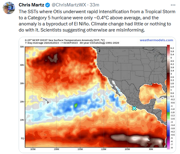

-
Temperatures will remain at above and much above normal levels into the weekend. During the peak of the warmth, the temperature will likely reach into the 70s into southern and central New England. Parts of the Middle Atlantic Region Baltimore, Newark, Philadelphia,and Washington, DC could reach 80°. Much colder air will return to close out October. November will commence with the coldest weather so far this season. October is solidly on track to finish as a warmer than normal month. Since 1950, only a single El Niño event with a monthly ENSO R3.4 anomaly of +1.00°C or above was warmer than normal in New York City during October: 2015 (sample size: 6). If one lowers the ENSO R3.4 anomaly to +0.75°C or above, only two 2/12 (17%) of El Niño cases saw a warmer than normal October in New York City: 1963 and 2015. Both years saw warm Octobers followed by warm Novembers. The ENSO Region 1+2 anomaly was +2.3°C and the Region 3.4 anomaly was +1.6°C for the week centered around October 18. For the past six weeks, the ENSO Region 1+2 anomaly has averaged +2.57°C and the ENSO Region 3.4 anomaly has averaged +1.57°C. El Niño conditions will likely continue to strengthen into the fall with the current East-based event transitioning to a basinwide El Niño for the upcoming winter. That transition is currently underway. The SOI was not available today. The preliminary Arctic Oscillation (AO) was -0.300 today. On October 22 the MJO was in Phase 6 at an amplitude of 0.879 (RMM). The October 21-adjusted amplitude was 0.563 (RMM). Based on sensitivity analysis applied to the latest guidance, there is an implied 99% probability that New York City will have a warmer than normal October (1991-2020 normal). October will likely finish with a mean temperature near 60.2° (2.3° above normal).
-
Occasional Thoughts on Climate Change
donsutherland1 replied to donsutherland1's topic in Climate Change
Another climate change denial claim aimed at discrediting climate research and its findings is below. It lacks credibility. Apparently, the author of the tweet never bothered to read the paper. The paper's explanation first appears in the second paragraph under the heading "Main." If one read that paragraph, one would understand that the paper made no claim that floating ice shelves are directly raising the sea-level. It observed that their melting is making it easier for upstream glaciers to flow towards the ocean. Those upstream glaciers—part of Antarctica’s ice sheet—is what is raising the sea-level. People can read the paper here: https://www.nature.com/articles/s41558-023-01818-x Science is not a "game" where one reacts reflexively to research without bothering to actually examine the content. Science is a rational and thoughtful undertaking.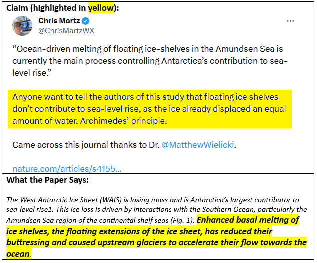
-
An impressive late October warmup is getting underway. Temperatures will surge to above and much above normal levels into the weekend. During the peak of the warmth, the temperature will likely reach into the 70s into southern and central New England. Parts of the Middle Atlantic Region Baltimore, Newark, Philadelphia,and Washington, DC could reach 80°. Much cooler air could return to close out October. All said, October is on track to finish as a warmer than normal month. Since 1950, only a single El Niño event with a monthly ENSO R3.4 anomaly of +1.00°C or above was warmer than normal in New York City during October: 2015 (sample size: 6). If one lowers the ENSO R3.4 anomaly to +0.75°C or above, only two 2/12 (17%) of El Niño cases saw a warmer than normal October in New York City: 1963 and 2015. Both years saw warm Octobers followed by warm Novembers. The ENSO Region 1+2 anomaly was +2.3°C and the Region 3.4 anomaly was +1.6°C for the week centered around October 18. For the past six weeks, the ENSO Region 1+2 anomaly has averaged +2.57°C and the ENSO Region 3.4 anomaly has averaged +1.57°C. El Niño conditions will likely continue to strengthen into the fall with the current East-based event transitioning to a basinwide El Niño for the upcoming winter. That transition is currently underway. The SOI was +0.77 today. The preliminary Arctic Oscillation (AO) was -0.051 today. On October 21 the MJO was in Phase 6 at an amplitude of 0.563 (RMM). The October 20-adjusted amplitude was 0.353 (RMM). Based on sensitivity analysis applied to the latest guidance, there is an implied 99% probability that New York City will have a warmer than normal October (1991-2020 normal). October will likely finish with a mean temperature near 60.2° (2.3° above normal).
-
Tomorrow through Tuesday will be chilly late autumnlike days. Some frost will be possible in areas outside New York City and Newark. However, by the middle of the week, temperatures will surge to above and much above normal levels. During the peak of the warmth, the temperature will likely reach 70° or above as far north as southern New England. Parts of the Middle Atlantic Region including Philadelphia could see the temperature top out in the middle and upper 70s. Baltimore and Washington, DC could reach 80°. Much cooler air could return to close out October. The recent guidance is notably warmer than had previously been the case. As a result, there is now a distinct possibility of a 60° October mean temperature in New York City. All said, October is on track to finish as a warmer than normal month. Since 1950, only a single El Niño event with a monthly ENSO R3.4 anomaly of +1.00°C or above was warmer than normal in New York City during October: 2015 (sample size: 6). If one lowers the ENSO R3.4 anomaly to +0.75°C or above, only two 2/12 (17%) of El Niño cases saw a warmer than normal October in New York City: 1963 and 2015. Both years saw warm Octobers followed by warm Novembers. The ENSO Region 1+2 anomaly was +2.3°C and the Region 3.4 anomaly was +1.6°C for the week centered around October 18. For the past six weeks, the ENSO Region 1+2 anomaly has averaged +2.57°C and the ENSO Region 3.4 anomaly has averaged +1.57°C. El Niño conditions will likely continue to strengthen into the fall with the current East-based event transitioning to a basinwide El Niño for the upcoming winter. That transition is currently underway. The SOI was -7.22 today. The preliminary Arctic Oscillation (AO) was +0.005 today. On October 20 the MJO was in Phase 7 at an amplitude of 0.353 (RMM). The October 19-adjusted amplitude was 0.278 (RMM). Based on sensitivity analysis applied to the latest guidance, there is an implied 98% probability that New York City will have a warmer than normal October (1991-2020 normal). October will likely finish with a mean temperature near 60.2° (2.3° above normal).
-
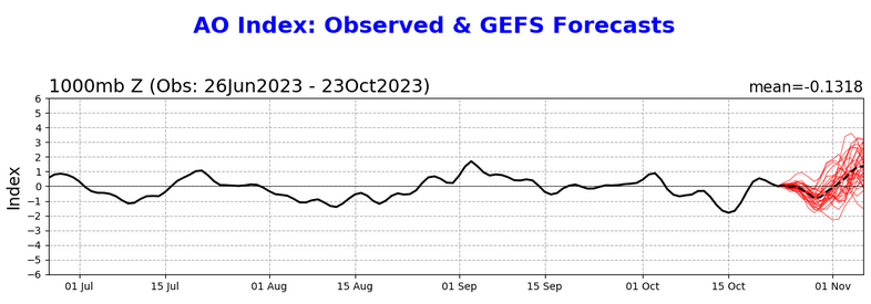
The tendency toward a strengthening SPV may be starting to show up in the extended range of the AO forecast, which is now showing a pronounced rise.