donsutherland1
-
Posts
23,765 -
Joined
Content Type
Profiles
Blogs
Forums
American Weather
Media Demo
Store
Gallery
Everything posted by donsutherland1
-
Jan 15-16 Storm Thread 3: Obs and Disco
donsutherland1 replied to stormtracker's topic in Mid Atlantic
Richmond (the Airport) has flipped to light snow. -
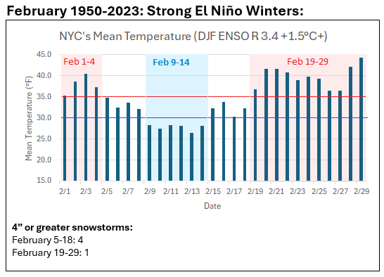
For those looking beyond the warmup following next weekend's cold shot, here's how February looked for ENSO cases where the tri-monthly ENSO Region 3.4 anomaly reached +1.5°C or above: Those are mean temperatures and there was substantial variability year-to-year. The key insight is that there should be a return of colder weather for at least a time.
-
I’m thinking around 6”, but ratios should be high and the snow fluffy. Maybe the highest elevations will see 8”.
-
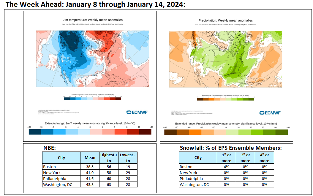
It has been an impressively warm start to winter and the first half of January. The magnitude of the warmth makes it likely that winter 2023-24 will go in the books as yet another warmer than normal winter.
-
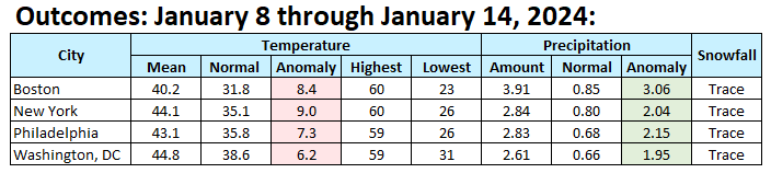
Weekly outcomes: Overall, the period wound up even warmer than had been suggested on the guidance. It was also very wet as highlighted by the guidance.

-
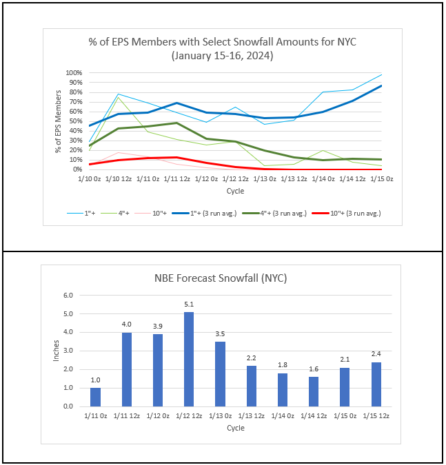
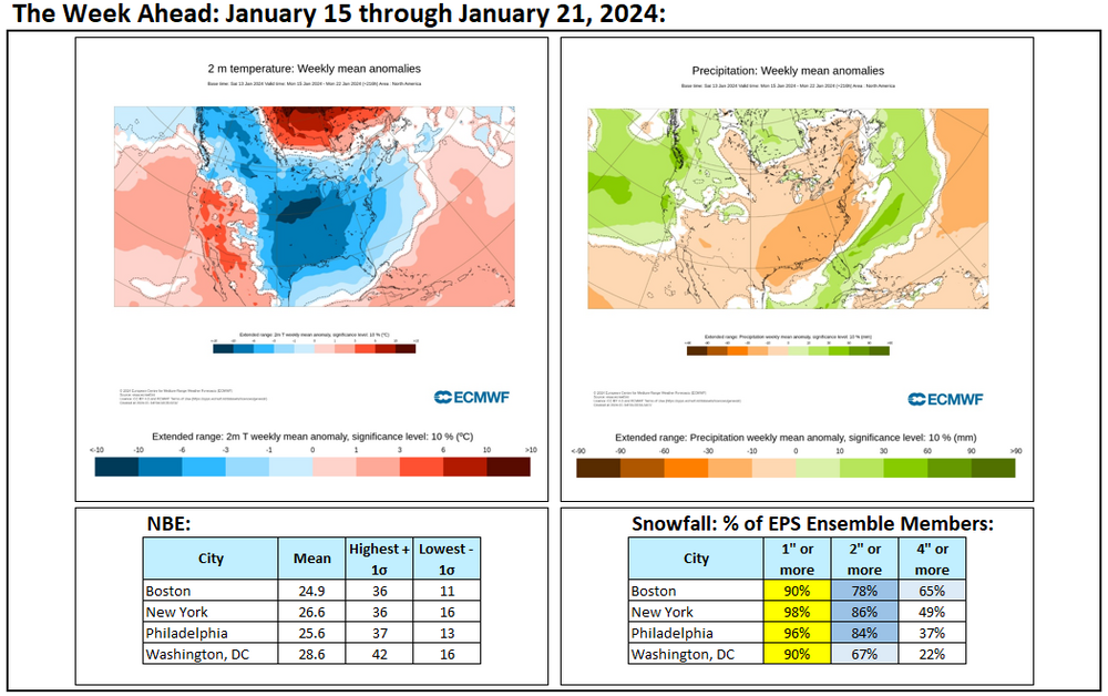
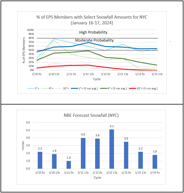
Light snow commenced in Baltimore just before 8:30. The snow will be marching slowly northward, reaching Philadelphia between 4 pm and 7 pm, Newark and New York City between 6 pm and 9 pm, and Bridgeport between 8 pm and 10 pm. It is possible that Central Park's streak without 1" daily snowfall could continue today, but the streak should be brought to an end by the storm with a general 1"-3" falling across the New York City Metro Area. Latest EPS and NBE numbers: The snow is coming.
-
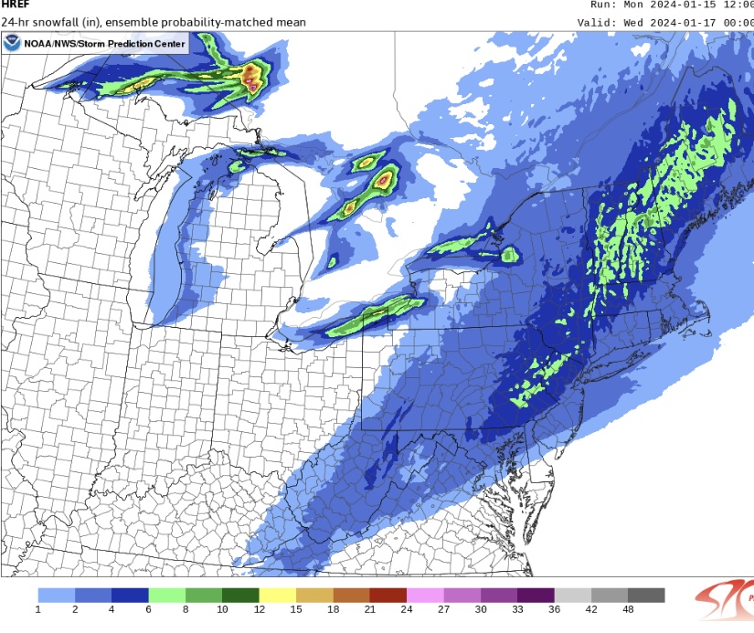
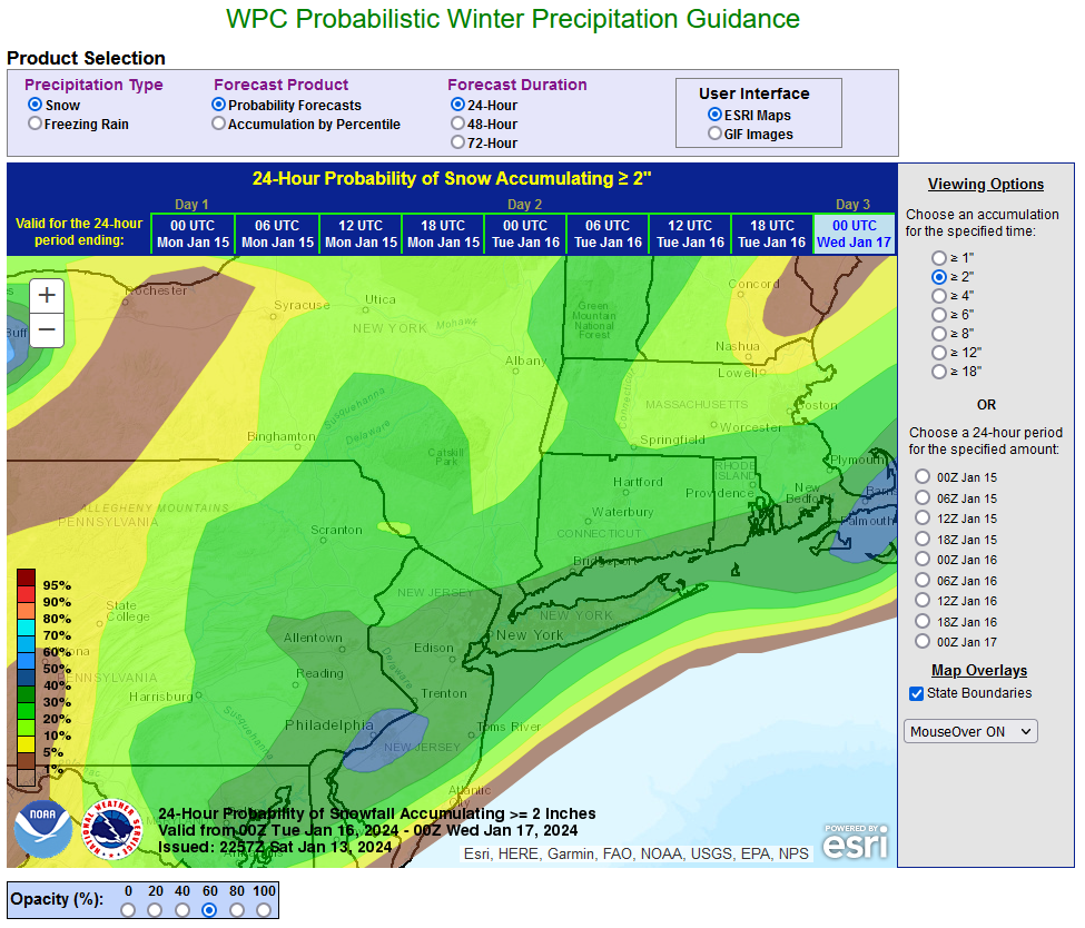
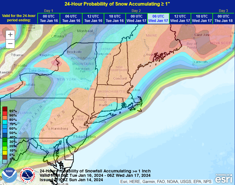
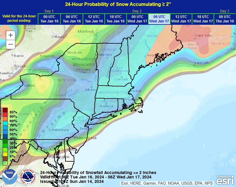
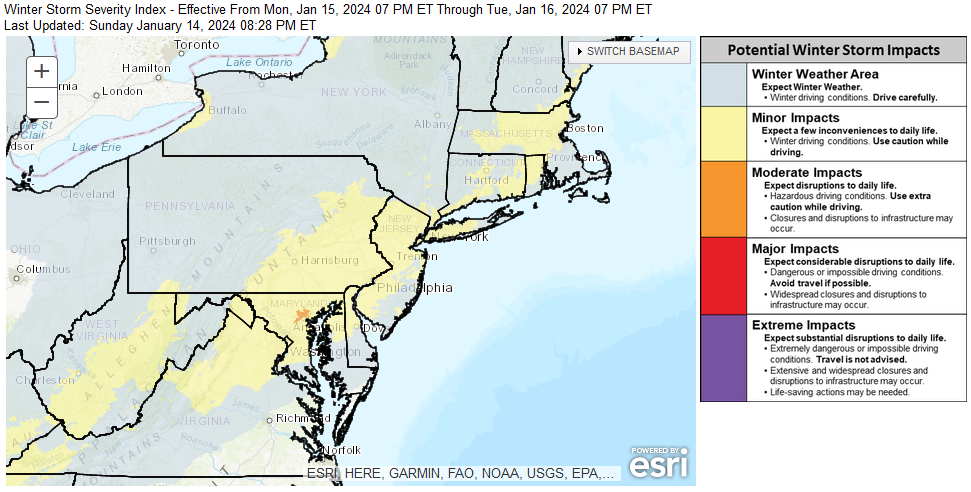
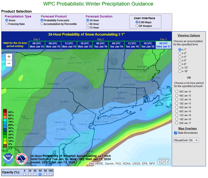
Things remain on track for a general 1"-3" snowfall tomorrow night and Tuesday. There is now a good consensus among the guidance. The coming snowfall will likely to end record streaks with less than 1" daily snowfall at Atlantic City, Baltimore, New York City (Central Park), Philadelphia, and Sterling. Snowfall ratios in New York City and nearby areas will generally be in the 9:1 to perhaps 12:1 range unlike with the January 6-7 storm where ratios were barely above 1:1 in the New York City area. EPS and NBE Data: WPC Probability of 24-Hour Snowfall of 1" or More: WPC Probability of 24-Hour Snowfall of 2" or More: Overall, the storm should only have minor impacts even as it will be the biggest snowfall in nearly two years in New York City and Philadelphia. WPC's Winter Storm Severity Index:
-
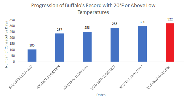
Buffalo saw the temperature fall below 20° today for the first time this season. The previous latest first occurrence of teens was January 3, 2016 and January 3, 2022. The Buffalo area, especially the Southtowns, was experiencing heavy lake effect snow. Nothing like that is occurring in the northern Middle Atlantic Region. Nevertheless, in the wake of this afternoon's snow flurries and snow showers, a significant push of cold air is underway. This cold air mass will set the stage for a snow event across the region. A storm will likely bring a general 1"-3" snowfall to Philadelphia, New York City, and Boston on Tuesday into Wednesday. Some uncertainty persists. However, consistent with historic climatology, a significant snowfall (general 6" or above snowfall) is not likely in the northern Mid-Atlantic region. Additional cold air will arrive following the storm and then late in the week following another storm. The low temperature could fall into the teens in New York City during the middle or end of the week for the first time this season. Friday or Saturday could afford another opportunity for snowfall. Beyond that, a noticeable warming trend that could send temperatures well into the 40s across the region and even into the 50s in parts of the region will likely commence. The ENSO Region 1+2 anomaly was +1.0°C and the Region 3.4 anomaly was +1.9°C for the week centered around January 3. For the past six weeks, the ENSO Region 1+2 anomaly has averaged +1.38°C and the ENSO Region 3.4 anomaly has averaged +1.97°C. A basinwide El Niño event is ongoing. The SOI was +26.53 today. The preliminary Arctic Oscillation (AO) was -2.459 today. Strong blocking in the final week of November, as occurred this year, has often been followed by frequent blocking in December and January. On January 12 the MJO was in Phase 3 at an amplitude of 1.365 (RMM). The January 11-adjusted amplitude was 1.127 (RMM). Based on sensitivity analysis applied to the latest guidance, there is an implied 66% probability that New York City will have a warmer than normal January (1991-2020 normal). January will likely finish with a mean temperature near 34.8° (1.1° above normal).
-
Buffalo saw the temperature fall below 20° for the first time this winter. That was the latest first teens on record. The old record was set on January 3, 2016 and tied on January 3, 2022. Buffalo's record 322-day streak with temperatures at or above 20° also came to an end.
-
Sunday 1-14-24 Snow Squalls & High Winds
donsutherland1 replied to Northof78's topic in New York City Metro
There was a brief snow shower in the White Plains area. Some dustings occurred in Armonk. -
Sunday 1-14-24 Snow Squalls & High Winds
donsutherland1 replied to Northof78's topic in New York City Metro
Flurries in Larchmont. -
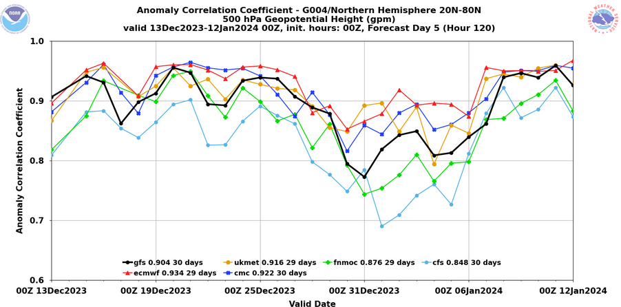
Both models had upgrades.
-
In terms of verification scores, the Canadian model consistently ranks third. Recently, it has ranked second.
-
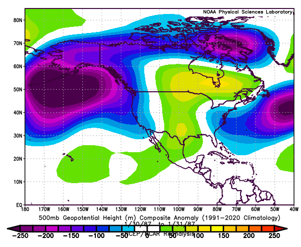
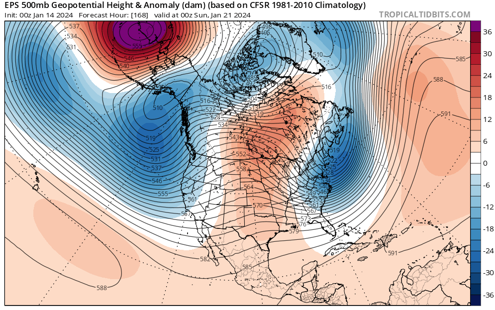
The potential is better, at least from this far out. There's a risk that it could wind up becoming a January 30-31, 1987-type event if the trough exits a bit faster than currently modeled. Were that to happen, eastern New England would be favored and New York City and southward could miss out on most of the snow. Long Island could still get brushed. During that event, Boston picked up 3.9" of snow, NYC had no measurable snow, and Philadelphia saw 0.4". There is a significant difference from 1987, as colder air should be available this time around. January 30-31, 1987 500 mb anomalies: EPS 500 mb anomalies: 168 hours
-
It will be tough to keep the streak doing through this week. Even if Tuesday's event falls apart, there's another shot Saturday.
-
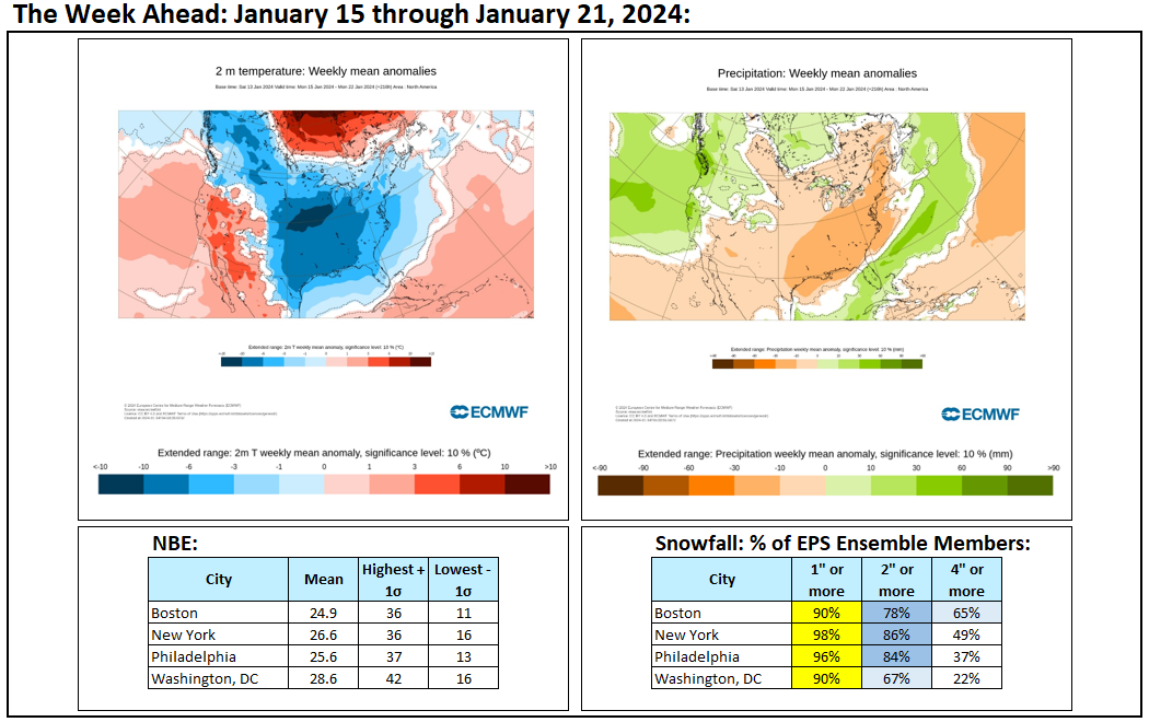
Weekly numbers: The most "winterlike" week so far this season lies ahead.
-
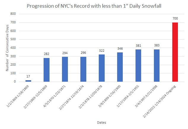
Today will be the 700th consecutive day on which New York City's Central Park has seen less than 1" daily snowfall. A system could end the streak on Tuesday.
-
A general 1" to perhaps 3" snowfall still appears likely for Philadelphia to Boston. There is a possibility that somewhat more snow could fall in and around the Boston area. There remains some uncertainty, but the guidance has been converging on a solution. WPC Maps: Latest EPS and NBE Data:

-
It’s difficult to know, because some observations inappropriately list hail as snow.
-
Another intense Great Lakes storm late Friday 1/12 with the brunt of 1" rain/shore gusts ~50 MPH Friday night, followed by widespread west gusts 40- possibly 50 MPH late Sat-Sun 1/13-14/2024. This serves as the OBS thread late Fri onward.
donsutherland1 replied to wdrag's topic in New York City Metro
Thanks. I had no flooding.- 90 replies
-
- 4
-

-
- flooding rains
- damaging wind? squalls?
- (and 2 more)
-
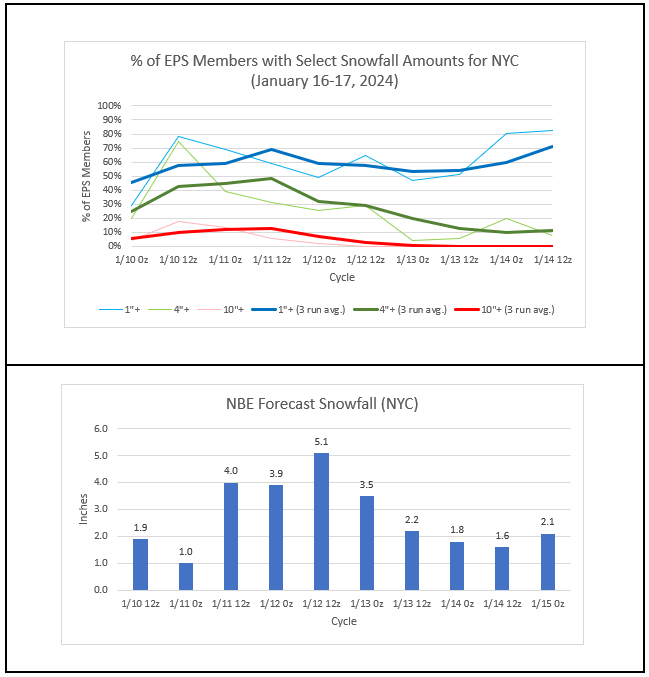
The most recent storm brought record daily rainfall amounts to a number of New England Cities and a general 0.50"-1.50" rainfall to the northern Mid-Atlantic region. Record daily rainfall amounts through 5 pm included: Boston: 1.41" (old record:" 1.36", 1979) Hartford: 1.20" (old record: 1.02", 1964) Portland: 2.43": (old record: 1.22", 1979) ***4th highest daily January precipitation*** Providence: 1.97": (old record: 1.52", 1948) Worcester: 1.33" (old record: 1.23", 1975) Parts of the region saw temperatures soar into the lower 60s. New York City reached 60° while Newark topped out at 61°. Boston also reached 60°. In the wake of the most recent storm that brought some record daily rainfall amounts to parts of New England, exceptionally high temperatures, and a record tide to Portland, more wintry weather will be pushing into the region. A strong cold front will cross the region tomorrow. The frontal passage could touch off snow showers and perhaps a snow squall. Areas north and west of New York City have the greatest chance of experiencing a snow squall. Any snow squall could bring briefly heavy snow, strong winds, and a quick coating to an inch of snow. There is even a chance that the grass in Central Park could be whitened. Arctic air will continue to advance deeper into the Continental U.S. over coming days. This cold air will come eastward in modified fashion with the brunt of the cold never quite making it to the major cities of the northern Middle Atlantic region. The low temperature could fall into the teens in New York City during the middle of next week for the first time this season. Prospects for at least some snowfall will increase following the coming weekend. One such opportunity exists for January 16-17. At present, it appears that Philadelphia, New York City, and Boston will see a general 1"-3" snowfall. Some uncertainty persists. January 20-21 could afford another opportunity for snowfall. Beyond that, a warming trend could commence. The ENSO Region 1+2 anomaly was +1.0°C and the Region 3.4 anomaly was +1.9°C for the week centered around January 3. For the past six weeks, the ENSO Region 1+2 anomaly has averaged +1.38°C and the ENSO Region 3.4 anomaly has averaged +1.97°C. A basinwide El Niño event is ongoing. The SOI was +23.84 today. The preliminary Arctic Oscillation (AO) was -2.442 today. Strong blocking in the final week of November, as occurred this year, has often been followed by frequent blocking in December and January. On January 11 the MJO was in Phase 3 at an amplitude of 1.127 (RMM). The January 10-adjusted amplitude was 1.237 (RMM). Based on sensitivity analysis applied to the latest guidance, there is an implied 60% probability that New York City will have a warmer than normal January (1991-2020 normal). January will likely finish with a mean temperature near 34.5° (0.8° above normal).
-
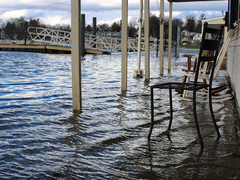
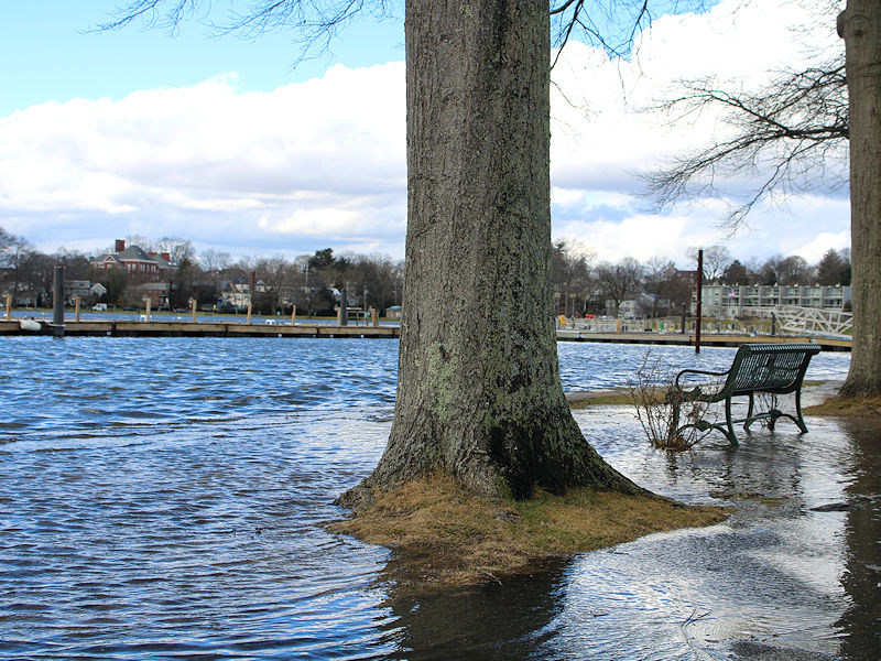
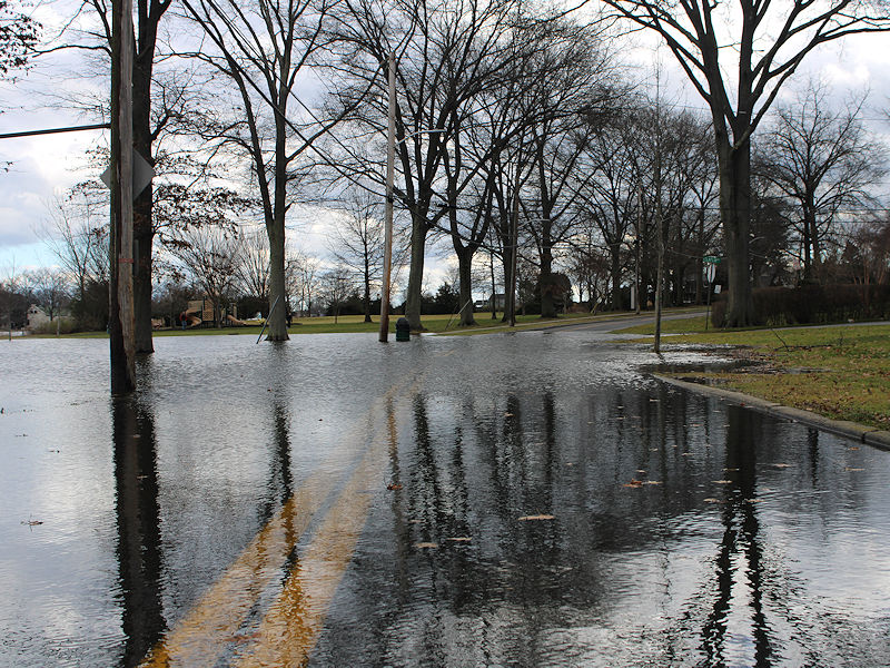
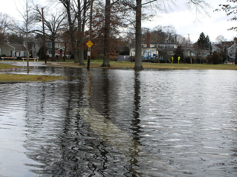
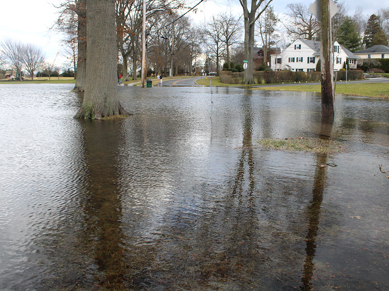
Another intense Great Lakes storm late Friday 1/12 with the brunt of 1" rain/shore gusts ~50 MPH Friday night, followed by widespread west gusts 40- possibly 50 MPH late Sat-Sun 1/13-14/2024. This serves as the OBS thread late Fri onward.
donsutherland1 replied to wdrag's topic in New York City Metro
Some photos of the storm tide in Mamaroneck, NY. Some yards and basements were flooded.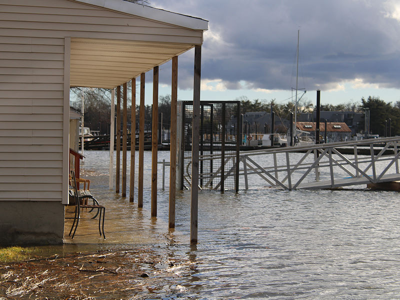
- 90 replies
-
- 7
-
-
- flooding rains
- damaging wind? squalls?
- (and 2 more)
-
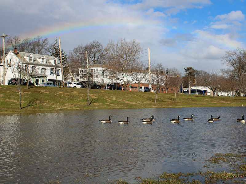
There were several sun showers and a rainbow in Mamaroneck about an hour ago.
-
Another intense Great Lakes storm late Friday 1/12 with the brunt of 1" rain/shore gusts ~50 MPH Friday night, followed by widespread west gusts 40- possibly 50 MPH late Sat-Sun 1/13-14/2024. This serves as the OBS thread late Fri onward.
donsutherland1 replied to wdrag's topic in New York City Metro
NYC: 60 at 10 am