donsutherland1
-
Posts
23,765 -
Joined
Content Type
Profiles
Blogs
Forums
American Weather
Media Demo
Store
Gallery
Everything posted by donsutherland1
-
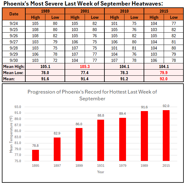
The latest guidance suggests that Phoenix will experience its hottest last week of September on record. Select record heat statistics for the last week of September are below.
-
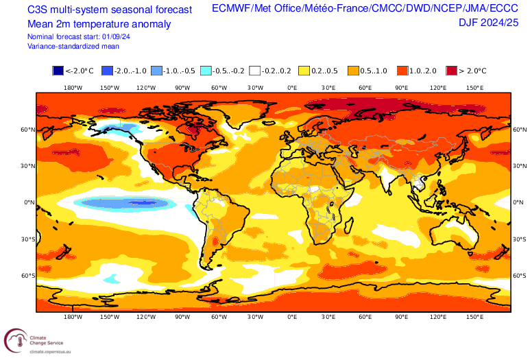
A generally pleasant temperature regime will continue through most or all of the week. Temperatures could top out in the upper 60s to lower 70s through the middle of the week before a slow warming trend commences afterward. Showers are possible on Wednesday and Thursday. Rainfall amounts should generally be light. In the Southwest and parts of California, yet more excessive heat is now developing. Parts of the region could see near record to record high temperatures on one or more days during the week. Phoenix could even see its highest temperatures so late in the season. In addition, a significant hurricane will likely make northwestern Florida landfall on Thursday. The potential exists for the storm to be a major hurricane on landfall given the ongoing marine heatwave in the region and relatively low shear. However, the hurricane's rainfall is unlikely to reach the New York City area. Early long-range guidance suggests that October could wind up warmer than normal across much of the U.S. Widespread October warmth occurred during the last case where the AO fell to -2.000 or below while the PNA rose to +1.000 or above with a cool ENSO Region 3.4 anomaly (2010), as was the case with the September 20th teleconnections. The NAO fell to a preliminary -2.472 today (all-time September record: -2.371, September 12, 1971). La Niña winters following September cases where the NAO fell to -1.900 or below featured a predominantly positive NAO. The most recent such winters were 2016-2017 and 2022-2023. The mean temperatures for those winters in New York City were 39.3° and 41.0° respectively. The 1991-2020 normal value is 36.2°. A warmer outcome is favored by the September run of the C3S multi-model forecast for Winter 2024-2025. The ENSO Region 1+2 anomaly was +0.2°C and the Region 3.4 anomaly was -0.5°C for the week centered around September 18. For the past six weeks, the ENSO Region 1+2 anomaly has averaged -0.20°C and the ENSO Region 3.4 anomaly has averaged -0.18°C. Neutral ENSO conditions will likely evolve into a La Niña event during the fall. The SOI was -3.98 today. The preliminary Arctic Oscillation (AO) was -1.948 today. Based on sensitivity analysis applied to the latest guidance, there is an implied 51% probability that New York City will have a cooler than normal September (1991-2020 normal). September will likely finish with a mean temperature near 69.1° (0.1° below normal).
- 1,154 replies
-
- 1
-

-
- tropics
- heavy rainfall
- (and 3 more)
-
Today's preliminary NAO value is -2.472, which would break the September record.
-
A generally pleasant temperature regime will continue through most or all of the week. Temperatures could top out in the upper 60s to lower 70s through the middle of the week before a slow warming trend commences afterward. Showers are likely on Wednesday and Thursday. Some uncertainty still exists concerning rainfall amounts. In the Southwest and parts of California, yet more excessive heat will develop early this week. Parts of the region could see near record to record high temperatures on one or more days during the week. Phoenix could even see its highest temperatures so late in the season. Early long-range guidance suggests that October could wind up warmer than normal across much of the U.S. Widespread October warmth occurred during the last case where the AO fell to -2.000 or below while the PNA rose to +1.000 or above with a cool ENSO Region 3.4 anomaly (2010), as was the case with the September 20th teleconnections. The NAO fell to a preliminary -1.909 today. La Niña winters following September cases where the NAO fell to -1.900 or below featured a predominantly positive NAO. The most recent such winters were 2016-2017 and 2022-2023. The mean temperatures for those winters in New York City were 39.3° and 41.0° respectively. The 1991-2020 normal value is 36.2°. A warmer outcome is favored by the September run of the C3S multi-model forecast for Winter 2024-2025. The ENSO Region 1+2 anomaly was -0.2°C and the Region 3.4 anomaly was -0.2°C for the week centered around September 11. For the past six weeks, the ENSO Region 1+2 anomaly has averaged -0.27°C and the ENSO Region 3.4 anomaly has averaged -0.10°C. Neutral ENSO conditions will likely evolve into a La Niña event during the fall. The SOI was -1.07 today. The preliminary Arctic Oscillation (AO) was -2.493 today. Based on sensitivity analysis applied to the latest guidance, there is an implied 53% probability that New York City will have a cooler than normal September (1991-2020 normal). September will likely finish with a mean temperature near 69.0° (0.2° below normal).
-
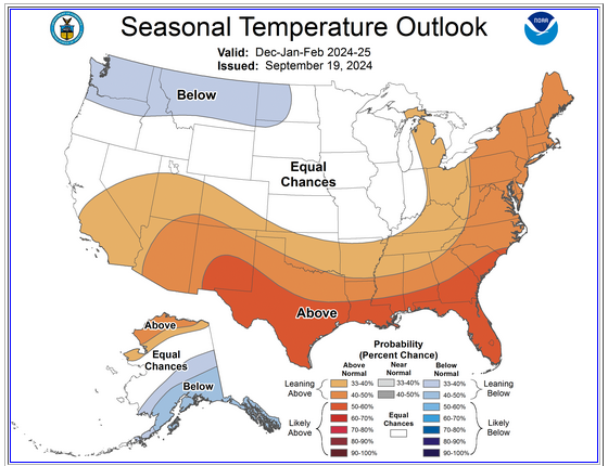
Today, the NAO fell to -1.900, which is very unusual for September. Since 1950, there have been three La Niña winters that followed such outcomes (1971-72, 2016-17, and 2022-23). All three favored a predominantly positive NAO during the winter. All three winters also favored warmer than normal winters in the eastern third to half of the CONUS. 2022-23 had solar activity that is most consistent with what is likely during the upcoming winter. Winter 2016-17 followed a strong El Niño winter, but the PDO was positive (very unlikely this time around). The composite for the two most recent winters (selected because they fall in the contemporary climate regime): For comparison, the latest C3S multi-model and CPC outlooks follow: C3S: CPC: It's early, so the C3S, which did well last winter from this timeframe (but hasn't always fared as well, might be aggressive and overly expansive with the warmth. For example, the Great Lakes Region (Chicago to Toronto) might wind up milder than normal, but not excessively so, with normal to somewhat above normal snowfall. Overall, the latest NMME (9/8 0z initialization) has an outlook that closely resembles the anomaly patter (but not necessarily the values) shown on the C3S. The CFSv2 offers a sort of compromise between the CPC outlook and the C3S.
-
I suspect 2021-22 will probably offer better insight, but it's still early.
-
It's a factor to watch. However, at this time, I suspect that the very strongly negative PDO will have a larger impact on the pattern, which would impede a deep or sustained EPO-.
-
Not all, but some seasonal forecast methodologies are failing. On Social Media, there were several winter forecasts that assumed, for example, that the East would be cold and snowy (it was again much warmer than normal with much lower than normal snowfall). CPC did well. The North Pacific marine heatwave is impacting PDO. That marine heatwave wasn't around in the 1980s or 1990s. Moreover, the likelihood of such a heatwave is much greater today than it was then.
-
Cooler air will arrive overnight. Temperatures could top out in the upper 60s to lower 70s through most of next week before a slow warming trend commences. Showers are also possible during the second half of next week. In the Southwest and parts of California, yet more excessive heat could develop early next week. Parts of the region could see near record to record high temperatures on one or more days next week. Early long-range guidance suggests that October could wind up warmer than normal across much of the U.S. Widespread October warmth occurred during the last case where the AO fell to -2.000 or below while the PNA rose to +1.000 or above with a cool ENSO Region 3.4 anomaly (2010), as was the case with the September 20th teleconnections. The ENSO Region 1+2 anomaly was -0.2°C and the Region 3.4 anomaly was -0.2°C for the week centered around September 11. For the past six weeks, the ENSO Region 1+2 anomaly has averaged -0.27°C and the ENSO Region 3.4 anomaly has averaged -0.10°C. Neutral ENSO conditions will likely evolve into a La Niña event during the fall. The SOI was +1.31 today. The preliminary Arctic Oscillation (AO) was -2.603 today. That is the second lowest value for September 21. Only September 21, 2010 (-2.675) had a lower value. That is also the fifth lowest value for any September day. Based on sensitivity analysis applied to the latest guidance, there is an implied 57% probability that New York City will have a cooler than normal September (1991-2020 normal). September will likely finish with a mean temperature near 68.9° (0.3° below normal).
-
Arctic Sea Ice Extent, Area, and Volume
donsutherland1 replied to ORH_wxman's topic in Climate Change
It just missed, as I posted above (4.073 million square kilometers, 6th lowest figure). -
Occasional Thoughts on Climate Change
donsutherland1 replied to donsutherland1's topic in Climate Change
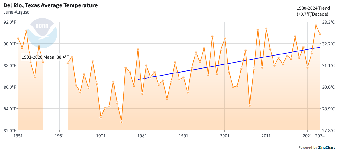
I'm not sure whether the 1950s era temperatures preceding the break were from a somewhat different location. Here are the Del Rio Area threaded summer means:
-
Climate change is influencing patterns, particularly from large-scale marine heatwaves. The current PDO- is one example. The increased frequency of the MJO's residing in the Marine Continent phases is another. That's why some seasonal forecasting methodologies based largely on analogs (even when the variables closely fit) now consistently perform poorly.
-
Occasional Thoughts on Climate Change
donsutherland1 replied to donsutherland1's topic in Climate Change
Yesterday, Del Rio recorded its 69th day of the year with a low temperature of 80° or above. That broke the record of 68 days that was set just last year. Del Rio has seen a recent explosion in such warm nights. Climate change is largely responsible. Urban Heat Island (UHI) Effect has played little role. Del Rio's population figures since 1980: 1980 30,034 1990 30,705 2000 35,867 2010 35,591 2020 34,673 2024 34,532 Summers have been warming about 0.7° per decade. This year also saw Del Rio tie its record for most 100° days with 91 such days. That record was also set just last year. Overall, recent years have been the warmest on record for Del Rio. 2019-2023 ranked as follows: 2019 10th warmest (tied with 2000) 2020 3rd warmest 2021 2nd warmest 2022 5th warmest 2023 1st warmest Through September 20th, 2024 is running 0.1° ahead of 2023 for the warmest year on record. Del Rio's records go back to December 1905.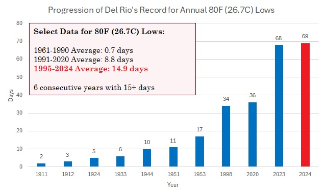

-
It will be variably cloudy and somewhat cooler tomorrow and Saturday. A few showers are possible on parts of Long Island and eastern Connecticut. A fresh shot of cooler air could arrive for Sunday. Temperatures could top out in the upper 60s to lower 70s through the middle of next week before a slow warming trend commences. Showers are also possible during the second half of next week. Early long-range guidance suggests that October could wind up warmer than normal across much of the U.S. Widespread October warmth occurred during the last case where the AO fell to -2.000 or below while the PNA rose to +1.000 or above with a cool ENSO Region 3.4 anomaly (2010), as was the case with the September 20th teleconnections. The ENSO Region 1+2 anomaly was -0.2°C and the Region 3.4 anomaly was -0.2°C for the week centered around September 11. For the past six weeks, the ENSO Region 1+2 anomaly has averaged -0.27°C and the ENSO Region 3.4 anomaly has averaged -0.10°C. Neutral ENSO conditions will likely evolve into a La Niña event during the fall. The SOI was +3.69 today. The preliminary Arctic Oscillation (AO) was -2.389 today. Based on sensitivity analysis applied to the latest guidance, there is an implied 60% probability that New York City will have a cooler than normal September (1991-2020 normal). September will likely finish with a mean temperature near 68.8° (0.4° below normal).
-
It will be variably cloudy tomorrow and somewhat cooler tomorrow and Saturday. A few showers are possible on parts of Long Island and eastern Connecticut. A fresh shot of cooler air could arrive for Sunday. Boston picked up 0.01" of rain today. That ended its 29-day stretch without measurable precipitation, which was tied for the 4th longest on record. Records go back to 1872. The ENSO Region 1+2 anomaly was -0.2°C and the Region 3.4 anomaly was -0.2°C for the week centered around September 11. For the past six weeks, the ENSO Region 1+2 anomaly has averaged -0.27°C and the ENSO Region 3.4 anomaly has averaged -0.10°C. Neutral ENSO conditions will likely evolve into a La Niña event during the fall. The SOI was +8.44 today. The preliminary Arctic Oscillation (AO) was -1.558 today. Based on sensitivity analysis applied to the latest guidance, there is an implied 59% probability that New York City will have a cooler than normal September (1991-2020 normal). September will likely finish with a mean temperature near 68.8° (0.7° below normal).
- 1,154 replies
-
- 1
-
-
- tropics
- heavy rainfall
- (and 3 more)
-
Occasional Thoughts on Climate Change
donsutherland1 replied to donsutherland1's topic in Climate Change
The Washington Post has published a story concerning an important paper covering the Earth's climate over the past 485 million years. The paper found that climate fluctuations were sharper and more sudden than previously modeled. The paper also revealed that CO2 was a key driver of climatic shifts. Excerpts from The Washington Post: An ambitious effort to understand the Earth’s climate over the past 485 million years has revealed a history of wild shifts and far hotter temperatures than scientists previously realized — offering a reminder of how much change the planet has already endured and a warning about the unprecedented rate of warming caused by humans. The timeline, published Thursday in the journal Science, is the most rigorous reconstruction of Earth’s past temperatures ever produced, the authors say. Created by combining more than 150,000 pieces of fossil evidence with state-of-the-art climate models, it shows the intimate link between carbon dioxide and global temperatures and reveals that the world was in a much warmer state for most of the history of complex animal life... “Carbon dioxide is really that master dial,” Tierney said. “That’s an important message … in terms of understanding why emissions from fossil fuels are a problem today.” https://wapo.st/4dc2CTV The underlying paper can be found here: https://www.science.org/doi/10.1126/science.adk3705 -
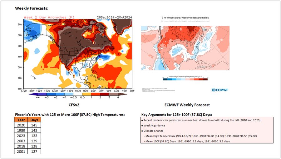
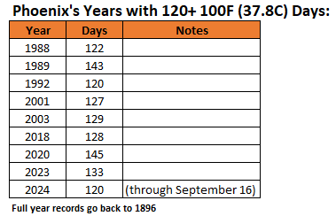
Phoenix has seen 120 100F (37.8C) or hotter days this year (tied for 8th highest with 1992). Phoenix will very likely reach or exceed 125 such days for the second consecutive year. There has never been 2 consecutive such years. 130+ days is possible.
-
Arctic Sea Ice Extent, Area, and Volume
donsutherland1 replied to ORH_wxman's topic in Climate Change
The final Arctic sea ice extent minimum this year on JAXA was 4.073 million square kilometers. That was the 6th lowest figure on record and lowest since 2020. Even more remarkable, this low figure occurred during a summer when conditions were unusually favorable for preserving Arctic sea ice extent. In the meantime, volume dropped to a record low. -
Some moisture from the southeast could bring some showers to the northern Mid-Atlantic region tomorrow and Friday. Any rainfall amounts from New York City northward should generally be light. After a day with highs in the upper 70s and lower 80s tomorrow, it will turn somewhat cooler for Friday and Saturday. A fresh shot of cooler air could arrive for Sunday. In terms of dry weather regionally, today is on track to become Boston's 29th consecutive day without measurable precipitation. That would be tied for the 4th longest dry stretch on record. Records go back to 1872. Measurable rainfall is likely in Boston late tonight and tomorrow. The ENSO Region 1+2 anomaly was -0.2°C and the Region 3.4 anomaly was -0.2°C for the week centered around September 11. For the past six weeks, the ENSO Region 1+2 anomaly has averaged -0.27°C and the ENSO Region 3.4 anomaly has averaged -0.10°C. Neutral ENSO conditions will likely evolve into a La Niña event during the fall. The SOI was +1.37 today. The preliminary Arctic Oscillation (AO) was -1.127 today. Based on sensitivity analysis applied to the latest guidance, there is an implied 65% probability that New York City will have a cooler than normal September (1991-2020 normal). September will likely finish with a mean temperature near 68.6° (0.5° below normal).
-
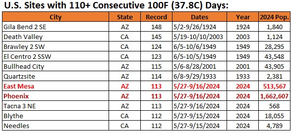
2024 was the first year that saw large or major U.S. population centers affected by extreme duration heatwaves (100 or more consecutive days with 100° or above high temperatures). East Mesa and Phoenix, both of which are the only population centers with 250,000 or more people to experience such streaks went on to record 113 consecutive 100° or above highs. The list for 110+ such consecutive days is below.
-
Some moisture from the southeast will likely bring showers and perhaps some periods of rain to the northern Mid-Atlantic region tomorrow. Showers could persist into Friday. Rainfall amounts from New York City northward have fallen in the recent guidance as the high to the north turns out somewhat stronger and more expansive than modeled during recent days. In terms of dry weather regionally, today is on track to become Boston's 28th consecutive day without measurable precipitation. That would be tied for the 5th longest dry stretch on record. Records go back to 1872. Some of the guidance brings light but measurable rainfall to Boston tomorrow or Thursday. The ENSO Region 1+2 anomaly was -0.2°C and the Region 3.4 anomaly was -0.2°C for the week centered around September 11. For the past six weeks, the ENSO Region 1+2 anomaly has averaged -0.27°C and the ENSO Region 3.4 anomaly has averaged -0.10°C. Neutral ENSO conditions will likely evolve into a La Niña event during the fall. The SOI was -5.17 yesterday. The preliminary Arctic Oscillation (AO) was -0.871 today. Based on sensitivity analysis applied to the latest guidance, there is an implied 62% probability that New York City will have a cooler than normal September (1991-2020 normal). September will likely finish with a mean temperature near 68.7° (0.4° below normal).
- 1,154 replies
-
- 1
-
-
- tropics
- heavy rainfall
- (and 3 more)
-
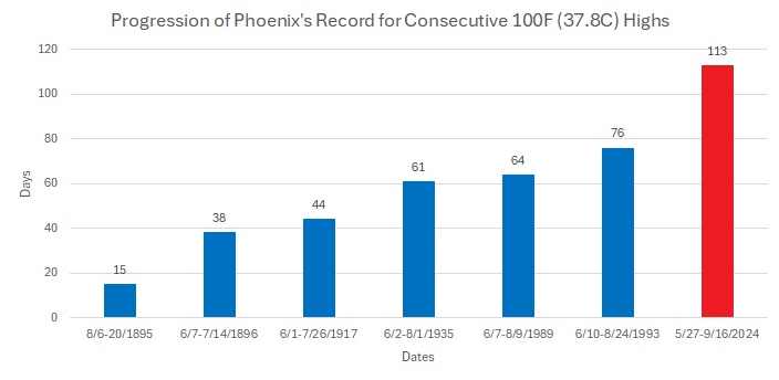
Phoenix saw its record 113-day streak of 100° temperatures end today. Prior to this year, Phoenix has never had a stretch more than 76 days.
-
Around 16.5" at Central Park. Below normal, but much better than the past two winters.
-
Phoenix reached 100° for the 113th consecutive day and 120th day overall this year. Six of the nine years with 120 such days have occurred since 2000 and all have occurred since 1988.
-
Dry conditions will likely persist into late tomorrow or tomorrow night. Afterward, moisture from the southeast will likely bring showers and some periods of rain to the northern Mid-Atlantic region. Showers could persist into Friday. Total rainfall from late Tuesday into Friday should average about 0.25"-0.75" in an around New York City (lesser amounts to the north and east of the City) and 0.50"-1.50" in Philadelphia, Baltimore and Washington, DC. In terms of dry weather regionally, today is on track to become Boston's 27th consecutive day without measurable precipitation. That would be the 6th longest dry stretch on record. Records go back to 1872. Some of the guidance brings light but measurable rainfall to Boston Wednesday or Thursday. The ENSO Region 1+2 anomaly was -0.2°C and the Region 3.4 anomaly was -0.2°C for the week centered around September 11. For the past six weeks, the ENSO Region 1+2 anomaly has averaged -0.27°C and the ENSO Region 3.4 anomaly has averaged -0.10°C. Neutral ENSO conditions will likely evolve into a La Niña event during the fall. The SOI was -5.17 today. The preliminary Arctic Oscillation (AO) was -0.622 today. Based on sensitivity analysis applied to the latest guidance, there is an implied 59% probability that New York City will have a cooler than normal September (1991-2020 normal). September will likely finish with a mean temperature near 68.8° (0.3° below normal).