donsutherland1
-
Posts
23,763 -
Joined
Content Type
Profiles
Blogs
Forums
American Weather
Media Demo
Store
Gallery
Everything posted by donsutherland1
-
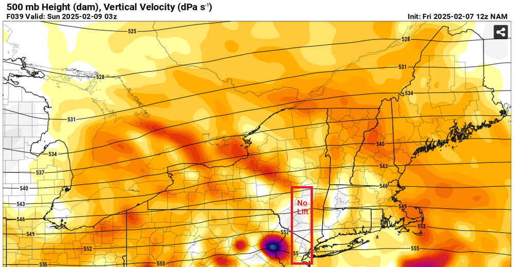
It's more complicated. If one looks at the 500 mb verical velocity maps, there's a large area of no or poor lift. Where temperatures are marginal, one can see sleet or no precipitation while lift is poor or non-existent. Where it's sufficiently cold, there can be light snow or flurries. This can happen during the transition from the primary to the secondary storm. A long transition can lead to a prolonged period where there is little or no precipitation. The depiction is from the 12z NAM.
-
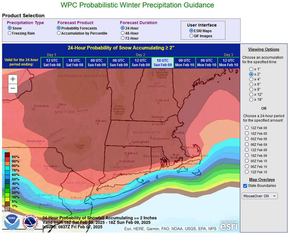
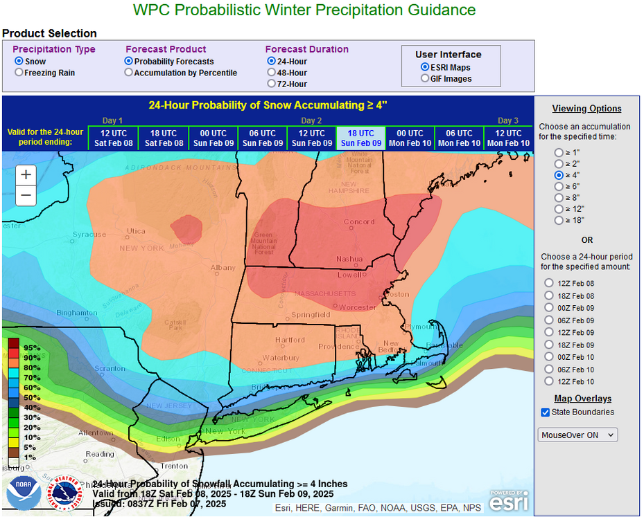
This event continues to look like the biggest one so far this winter for the New York City region.
-
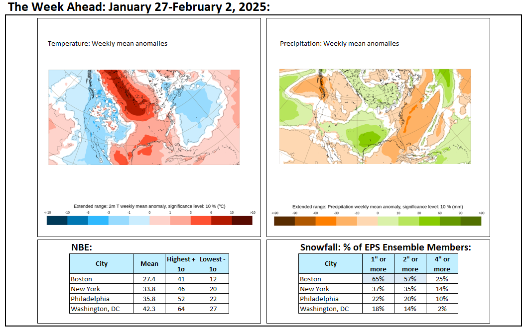
Tomorrow will be partly sunny and brisk. Another system could bring snow changing to rain Saturday night into Sunday. New York City will likely see more snow than with today's storm (possibly a 1"-3"/2"-4" type event). No exceptional warmth or cold is likely through at least February 14th. There remains uncertainty about the second half of the month with regard to temperature anomalies. Precipitation will likely be near or somewhat above normal. The AO is positive and is expected to remain predominantly positive through the first week of February before falling sharply. Since 1950, just 2 of 19 (11%) of storms with an AO of +2.000 or above during January 15-February 15 saw 6" or more of snow in New York City. In addition, the NAO is likely to remain at +1.000 or above through the first 10-14 days of February. Since 1950, just 1 of 18 (6%) of storms with an NAO of +0.900 or above saw 6" or more snow in New York City. That storm occurred with an AO of -1.769. As a result, prospects for a 6" or above snowstorm in the New York City area will likely be limited through at least the first 10 days of February. The low probability of a 6" or above snowstorm does not mean that there cannot be snowfall or that there won't be snowfall. Smaller events are possible, as occurred on February 2 and today. After February 10th, there could be a window of opportunity for a larger event, possibly 6" or more. The forecast pattern has some similarities with that February 8-9, 1994 when New York City picked up 9.0" of snow. However, the air mass during 1994 was substantially colder than the one that is forecast for next week. The ENSO Region 1+2 anomaly was -0.6°C and the Region 3.4 anomaly was -0.8°C for the week centered around January 29. For the past six weeks, the ENSO Region 1+2 anomaly has averaged -0.13°C and the ENSO Region 3.4 anomaly has averaged -0.63°C. La Niña conditions are underway and will likely persist into the start of spring. The SOI was +31.65 today. The preliminary Arctic Oscillation (AO) was +1.259 today.
-
The PSL and CDC pages are back online. Apparently, it was power maintenance that was responsible for their having been down earlier. Here's the after-the-maintenance banner:

-
I had wanted to run the 500 mb composites for NYC's 6" or greater snowstorms during AO-/NAO+ patterns to create clusters. There were 9 such storms. Seven also brought 6" or more to Boston while four also brought 6" or more to Philadelphia (and also Boston). After the 10th, there may be opportunity for a 6"+ snowstorm, but there is no guarantee. New England has a higher probability. The pattern clusters could provide some insight regarding the New York City area. Synoptic details will be crucial, but that information won't become reliable until the closer range when model skill increases. Unfortunately, at present, the site is down.
-
2008-09 reached 10" seasonal snowfall on its 8th day with measurable snowfall. 2006-07 took 12 days to get to 10".
-
Winds. It also takes time to cool waters that had been abnormally warm coming into the winter.
-
Today is the 7th day with measurable snowfall. Winter 1937-1938 had 14 days with measurable snowfall with less than 10" of snow. The 15th day reached and exceeded 10".
-
Light snow has transitioned to sleet in Larchmont.
-
For an update on the situation at the NOAA: https://abcnews.go.com/US/doge-now-access-noaas-systems-reviewing-dei-program/story
-
Colder air has returned to the region just in time for the arrival of another storm. A period of snow, sleet, and freezing rain is likely tonight into tomorrow. New York City and nearby suburbs will likely see 0.5"-1.5" of snow and sleet before a brief transition to freezing rain and then rain. 1"-3" is likely in the distant northern and western suburbs before the precipitation changes over to freezing rain and rain. Northwest New Jersey into adjacent southeast New York could experience an extended period of freezing rain. Another system could bring snow changing to rain on Sunday. No exceptional warmth or cold is likely through at least February 14th. There remains uncertainty about the second half of the month with regard to temperature anomalies. Precipitation will likely be near or somewhat above normal. The AO is now positive and is expected to remain predominantly positive through the first week of February before falling sharply. Since 1950, just 2 of 19 (11%) of storms with an AO of +2.000 or above during January 15-February 15 saw 6" or more of snow in New York City. In addition, the NAO is likely to remain at +1.000 or above through the first 10-14 days of February. Since 1950, just 1 of 18 (6%) of storms with an NAO of +0.900 or above saw 6" or more snow in New York City. That storm occurred with an AO of -1.769. As a result, prospects for a 6" or above snowstorm in the New York City area will likely be limited through at least the first 10 days of February. The low probability of a 6" or above snowstorm does not mean that there cannot be snowfall or that there won't be snowfall. Smaller events are possible, as occurred on February 2. The ENSO Region 1+2 anomaly was -0.6°C and the Region 3.4 anomaly was -0.8°C for the week centered around January 29. For the past six weeks, the ENSO Region 1+2 anomaly has averaged -0.13°C and the ENSO Region 3.4 anomaly has averaged -0.63°C. La Niña conditions are underway and will likely persist into the start of spring. The SOI was +24.50 today. The preliminary Arctic Oscillation (AO) was +1.439 today.
-
There's a lot more than just the models being at risk. NWS forecasting jobs, research, digital content, etc., could all be at risk. There's also the possibility that a lot of what is public could be privatized. Already, the Musk team has made a move in that direction by eliminating the IRS's free e-file platform.
-
FYI: https://www.theguardian.com/us-news/2025/feb/04/doge-noaa-headquarters
-
Another brief cold shot is likely tomorrow before temperatures moderate yet again. No exceptional warmth or cold is likely through at least February 10th. A period of snow, sleet, and freezing rain is likely tomorrow night and Thursday. Currently, this appears to be the kind of event that could bring a coating to 1" of snow and sleet to New York City and nearby suburbs and 1"-3" in its distant northern and western suburbs before the precipitation changes over to freezing rain (mainly outside the City) and rain. Northwest New Jersey into adjacent southeast New York could experience an extended period of freezing rain. There remains uncertainty about the second half of the month. Precipitation will likely be near or somewhat above normal. The AO is now positive and is expected to remain predominantly positive through the first week of February before falling sharply. Since 1950, just 2 of 19 (11%) of storms with an AO of +2.000 or above during January 15-February 15 saw 6" or more of snow in New York City. In addition, the NAO is likely to remain at +1.000 or above through the first 10-14 days of February. Since 1950, just 1 of 18 (6%) of storms with an NAO of +0.900 or above saw 6" or more snow in New York City. That storm occurred with an AO of -1.769. As a result, prospects for a 6" or above snowstorm in the New York City area will likely be limited through at least the first 10 days of February. The low probability of a 6" or above snowstorm does not mean that there cannot be snowfall or that there won't be snowfall. Smaller events are possible, as occurred on February 2. The ENSO Region 1+2 anomaly was -0.6°C and the Region 3.4 anomaly was -0.8°C for the week centered around January 29. For the past six weeks, the ENSO Region 1+2 anomaly has averaged -0.13°C and the ENSO Region 3.4 anomaly has averaged -0.63°C. La Niña conditions are underway and will likely persist into the start of spring. The SOI was +18.35 today. The preliminary Arctic Oscillation (AO) was +1.701 today.
-
After the 10th things should be a lot more promising should the AO go negative. An AO-/NAO below +0.8 is viable.
-
Following last night's light snowfall, the temperature soared well into the 40s across the New York City area. The Philadelphia area saw some lower 50s. Tomorrow will be another mild day, but another brief cold shot is likely Wednesday before temperatures moderate yet again. Some snow, sleet, and freezing rain is also possible later Wednesday into Thursday. There remains some uncertainty about the second half of the month. The ECMWF weeklies are holding with below normal temperatures after having moved to a warmer than normal outlook a few days ago. The AO is now forecast to go strongly negative. These recent developments increase prospects for a colder pattern. Precipitation will likely be near or somewhat above normal. The AO is now positive and is expected to remain predominantly positive through the first week of February before falling sharply. Since 1950, just 2 of 19 (11%) of storms with an AO of +2.000 or above during January 15-February 15 saw 6" or more of snow in New York City. In addition, the NAO is likely to remain at +1.000 or above through the first 10-14 days of February. Since 1950, just 1 of 18 (6%) of storms with an NAO of +0.900 or above saw 6" or more snow in New York City. That storm occurred with an AO of -1.769. As a result, prospects for a 6" or above snowstorm in the New York City area will likely be limited through at least the first 10 days of February. The low probability of a 6" or above snowstorm does not mean that there cannot be snowfall or that there won't be snowfall. Smaller events are possible. The ENSO Region 1+2 anomaly was -0.6°C and the Region 3.4 anomaly was -0.8°C for the week centered around January 29. For the past six weeks, the ENSO Region 1+2 anomaly has averaged -0.13°C and the ENSO Region 3.4 anomaly has averaged -0.63°C. La Niña conditions are underway and will likely persist into the start of spring. The SOI was +20.65 today. The preliminary Arctic Oscillation (AO) was +1.329 today.
-
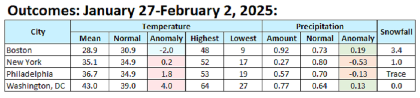
The final numbers: