Quincy
-
Posts
6,220 -
Joined
-
Last visited
Content Type
Profiles
Blogs
Forums
American Weather
Media Demo
Store
Gallery
Everything posted by Quincy
-

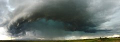
From the album: Summer 2016 Thunderstorms
A tornado-warned thunderstorm near Colorado Springs, Colorado shows signs of low-level rotation as it passes overhead. July 8th, 2016. -
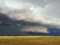
From the album: Summer 2016 Thunderstorms
A tornado-warned thunderstorm near Colorado Springs, Colorado takes on a shelf-like appearance. July 8th, 2016. -

From the album: Summer 2016 Thunderstorms
Thunderstorm structure near Westphalia, Iowa. July 7th, 2016. -

From the album: Summer 2016 Thunderstorms
A shelf cloud approaches from the west over the Badlands of South Dakota. July 6th, 2016. -

From the album: Summer 2016 Thunderstorms
A shelf cloud approaches from the west over the Badlands of South Dakota. July 6th, 2016. -
From the album: Summer 2016 Thunderstorms
A thunderstorm near Rapid City, South Dakota displays a low-hanging cloud base. July 6th, 2016. -
From the album: Summer 2016 Thunderstorms
An organizing thunderstorm near Rapid City, South Dakota begins to show signs of visible inflow. July 6th, 2016. -

From the album: Summer 2016 Thunderstorms
A low hanging cloud resembles a funnel cloud near Midway, Illinois. July 3rd, 2016. -

Central/Western Medium-Long Range Discussion
Quincy replied to andyhb's topic in Central/Western States
An ugly pattern coming up for the next week. Even next week's trough ejection may be muddled by continued troughing in the eastern U.S. It's not all that common for a lull in severe weather to start May, but still... -
Central/Western Medium-Long Range Discussion
Quincy replied to andyhb's topic in Central/Western States
In the past, they only did 30%, so it's not completely unprecedented. -
Central/Western Medium-Long Range Discussion
Quincy replied to andyhb's topic in Central/Western States
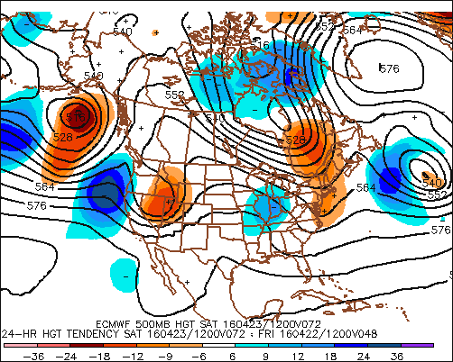
It's nice to see a stretch like this being modeled inside of 10 days. Of course details are subject to change, but this type of pattern should deliver at least one or two solid days:
-
April is seen as a transition month during the severe weather season, as the frequency of tornadoes typically picks up rather quickly through the month. Despite what the calendar has to say, tornado activity has been fairly lackluster so far this month. In fact, after moving well above the average to-date tornado count in late February, the U.S. has steadily been losing ground. As it stands now, through April 18, the U.S. is near average this year for tornadoes, but with a relatively quiet rest of the week forecast, it looks like the country will fall below average for the first time since February. (The 1986-2015 climate period of 30 years is used for this average) The month of April started with the “dreaded” trough of low pressure across the Northeast. Locally, it was cold and snowy after a winter that was relatively mild and snowless. Likewise, after an active winter season for tornadoes, severe activity has been sporadic over the past several weeks. With all of this said, a pattern change is finally on the not-to-distant horizon, with troughiness returning to the West and the welcomed return to ridging across the Southeast U.S. This pattern will broadly support a more active period of weather across the central states, including an uptick in tornado potential. If we’re keeping track, a pattern change was slated for mid-April a long time ago, back as early as mid-March. That pattern change has been delayed somewhat as pesky troughing across southeastern Canada hangs on and the models display a glaring ridge (positive height) bias. This past week saw a shuffling of the pattern, but an omega block led to a messy setup and only a few isolated tornado reports in parts of the High Plains. The models often have issues handling larger scale pattern changes, but now that such a change is effectively inside of a week, confidence is increasing and the models are getting into good agreement. By this weekend, the first in a series of troughs is likely to swing across the western half of the country with some modest ridging to the east. Watch for lee-side cyclogenesis in the central High Plains vicinity between Sunday and Monday. While this is encouraging, the setup is not without flaws. This first trough ejection and evolution of the system is kind of junky (for the lack of a better word) in terms of tornado potential. There’s some instability as early as Saturday progged in the north-central states, but shear is forecast to be lackluster. The similar is the case for Sunday and Monday from the Plains into the Upper Midwest – generally marginal overlays between modest shear and favorable instability as a frontal system slides east. This is subject to change, but the trends are not particularly impressive. It’s the middle and latter portion of next week that really bears watching, figuring that this first system may at least get the gears turning for building a warm, moist air-mass over the Plains. With the Euro and GFS in good agreement (including the ensembles), it’s fair to use the GEFS analogs as a baseline for what type of setup we could be looking at, somewhere in the Tuesday to Saturday (April 26-30th) time-frame. Even before looking at specific dates, the string of digging troughs in the West with increasing moisture return in the central states sets the stage for a classic period of near-peak/peak tornado season activity. This does not necessarily mean we will have a massive number of tornadoes or that there will be a high-end setup, but at the very least, it is probable that tornado activity will markedly pick up as the week wears on. Now speaking of those analogs, there are some big dates and periods that show up, in order from ranking: 5/10/1953: A couple of days removed from the day 6-10 analog, but this date featured a localized outbreak of strong tornadoes in the Upper Midwest. 4/25 – 4/29/1994: 124 tornadoes in five days, including an outbreak from the 25th into the 26th. 5/12 – 5/13/1980: Not an outbreak, but strong tornadoes in Missouri followed by a pair of EF-3 tornadoes in Michigan the next day. 4/17/1995: AR/OK/TX outbreak with 21 tornadoes. 4/26/1991: Plains outbreak with 53 tornadoes, including the Andover, KS EF-5 tornado. 5/2/1994: The only analog in this bunch that didn’t have notable tornado activity. 5/7 – 5/11/2008: 122 tornadoes in five days. (2008 has been an analog on the radar for a while, also one of the busiest spring seasons of this century) 5/8/1979: 21 tornadoes, though mostly in Florida, two were reported in Iowa, including an EF-3. 4/30/1978: 15 tornadoes in the southern Plains, including 6 strong tornadoes and a mile-wide EF-4 on the northwest side of Oklahoma City. 5/4 – 5/6/1960: 71 tornadoes in three days from the Plains into the Midwest, including a long-track EF-5 tornado in eastern Oklahoma. If the pattern unfolds closely to what is modeled, it would appear that April certainly has the potential to go out with a bang. Through some of the research I’ve done with a May tornado outlook for USTornadoes.com, I noticed that the analogs have things in common. Without giving away too many of the details, one of the common themes in the analog was for the potential for violent tornado events in May. It could be the case that we’re just getting warmed up next week…
-
Central/Western Medium-Long Range Discussion
Quincy replied to andyhb's topic in Central/Western States
High-end or not, at least the overall pattern signs are encouraging. Back in mid to late March, it looked like change was going to happen around mid-April and for a time, but then the models lost it, only to see it come back about a week to 10 days late of earlier indications. Now that it's on the horizon, the general pattern looks solid for next week and perhaps late this weekend out in the High Plains. (Weekend won't happen if the slowdown continues and we maintain neutral or rising heights) Moisture won't be an issue with much of the Plains drought knocked out this past week and Texas getting inundated once again with copious amounts of rain. As you mentioned, pesky troughing in southeast Canada/Northeast is probably the biggest issue. Either way, at least we should see severe activity steadily pick up for the last week or so of the month. Maybe with some luck April will only end up slightly below average for tornado counts. It's going to take a couple of big events or a very solid string of days to push the month to AOA average. -
Central/Western Medium-Long Range Discussion
Quincy replied to andyhb's topic in Central/Western States
That's true. Aside from the potential for one of these cutoffs to locally produce, we could just as easily see a pattern flip (models can and have been wrong in the long-range) or a random event pop up. Even the worst spring seasons have their share of events. Climo says it's very difficult to get through the last 10 days of April without some notable uptick in severe activity, if that's one piece of optimism I can throw out there. -
Central/Western Medium-Long Range Discussion
Quincy replied to andyhb's topic in Central/Western States
Weeklies essentially show CONUS riding from the last week of April, right through the end of the run. Bright side, maybe it will be wrong again, but on the realistic side, I am becoming increasingly skeptical about any significant pattern change for the better in terms of severe potential. -
Central/Western Medium-Long Range Discussion
Quincy replied to andyhb's topic in Central/Western States
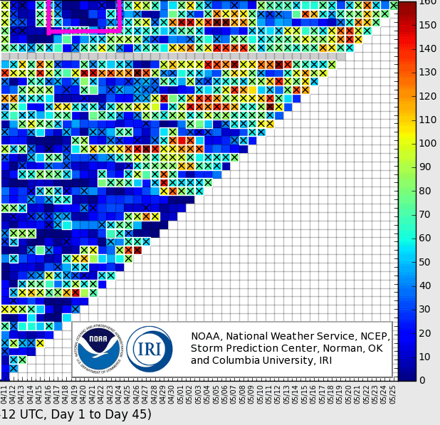
CFS has showed an overall dearth of potential for the same time-frame over the past few runs. This seems to line up with most medium-range guidance. Although the pattern isn't 0% supportive of severe, it's looking fairly likely that tornado activity will remain below average for the next 1-2 weeks. The weeklies will be out in a few hours, but the EPS/GEFS show little optimism through day 15.
-
A localized threat of severe thunderstorms, including possible tornadoes, targets Arkansas Sunday afternoon into the evening hours. A compact shortwave trough approaches from Oklahoma during the afternoon, with a modestly warm, moist flow from the south to southeast streaming up the lower Mississippi Valley. Computer forecast models have been quite consistent with this general threat for quite some time and now that Sunday is approaching, some high resolution, short-term guidance has been reviewed. Clusters of severe thunderstorms are expected to form during Sunday afternoon and track east to northeast across the region. Large hail and a few tornadoes are expected, along with damaging wind gusts and some localized flooding, mainly where any heavy rain falls over already saturated, or even flooded, areas. With the environment across the Arklatex vicinity being largely undisrupted, a corridor of moderate instability is progged from the Arkansas/Oklahoma border, southeastward across Arkansas and northern Louisiana. The focus for thunderstorm initiation will be immediately head of a weak surface low crossing over from Oklahoma into Arkansas. The 4km NAM has been consistent for several runs now, showing discrete cells forming on a northwest to southeast axis from approximately Fort Smith to Malvern and southward into southern Arkansas by mid-afternoon. Given the environment, supercells are likely with large hail being the initial threat, given cold air aloft and relatively steep mid-level lapse rates. By late afternoon, the tornado threat will likely increase due to several factors, including locally backed near-surface winds, an increasing low-level jet and terrain influences. The greatest apparent tornado threat will be from central to east-central Arkansas, given very good model agreement with the most robust cells forming in this location, just ahead of the surface low. There is also a possibility that moisture return may also be slightly underestimated by the models given recent rainfall across the region. Nonetheless, the setup may also take advantage of channeling of low level flow in the Arkansas Valley, as has been seen many times in the past, meaning that a tornado or two could also be possible between Conway and Fort Smith, on either side of I-40. The confidence in thunderstorm initiation decreases with southward extent, particularly from far southern Arkansas into northern Louisiana. Although some convection may fire here, the most robust storms are likely to remain farther north. Into the evening, the cells will mature and move northeastward, perhaps reaching the Memphis area before merging/weakening overnight. Both high resolution guidance and the GFS agree in a swath of heavy rain/convection from roughly Little Rock to Memphis. This means that some localized flooding may be possible here. Given the thermodynamic and kinematic environment, a strong tornado cannot be ruled out. Model QPF swaths all support the idea of discrete or semi-discrete convection, particularly from 21-03z from central to eastern Arkansas. One last note is that although models have been in strong agreement, there may be a very slight slowdown of the system, but this will not have major impacts on the outcome. It does mean that a few strong to perhaps severe thunderstorms may fire in eastern Oklahoma early in the event and that the severe threat will decrease with eastward extent, to the east of the Mississippi River.
-
Multiple variables are important to consider when it comes to supercell thunderstorm development. The Supercell Composite Parameter (SCP) was created to factor three important ingredients to determine how favorable an environment is to produce supercells. SCP focuses on instability, wind shear and helicity (potential for updraft rotation). SCP is a parameter that starts at zero and becomes higher as there is better overlap of parameters to favor the formation of supercells. For example, an SCP of zero suggests that supercells are unlikely to form, while a value of 10 suggests a much better likelihood of supercell formation. There will be more discussion later on as to what SCP values support supercells. Calculating SCP MUCAPE term * effective bulk shear term * effective SRH term instability term * wind shear term * helicity term The equation is more specifically (MUCAPE/1000 J•kg-1) * (EBWD/20 m•s-1) * (ESRH/50 m2s-2) This tells us that each variable has a “threshold” in the equation. Basically, instability of 1000 J•kg-1 will equal out to 1. For bulk shear, 20 m•s-1 (~39 knots) will bring that term to 1. With helicity, 50 m2s-2 is the threshold. (EBWD stands for effective bulk wind difference/shear) Effective shear is used instead of 0-6km shear, for example, since it takes into account storm depth. Effective SRH is used as opposed to standard SRH, as ESRH is tuned to discriminate against environments with considerable capping, that may prevent air from being able to rise and form a thunderstorm. An SCP value of 1 is relatively low and most surface-based supercells form when SCP is between 2 and 11. Values much higher are relatively uncommon, but when they do happen, there is a strong probability of supercell formation, assuming other ingredients come into play, such as forcing, breaching a cap and storm mode. The average value for SCP with supercells ends up being close to 6. There are some other considerations to make. Elevated supercells can and often form with "low" SCP values. In fact, some can form with an SCP value below 1 and the average value for elevated supercells is only about 2. An elevated supercell will form in an environment where there is elevated instability, but there may be a low-level inversion that prevents the supercell from routing itself at the surface. Likewise, marginal supercell structures that may be messy or disorganized, can also form with low SCP values. Also, an SCP value can be extremely high, such as 20+, but if there is no forcing mechanism to trigger thunderstorm initiation, there could easily be no supercells in such an environment. This seems to be most common on hot, summer days where there is extreme instability in place, but only modest wind shear/helicity. Below is an example from 2015 where SCP values were over 30 across parts of Kansas, largely due to extreme instability. However, a lack of forcing delayed supercell initiation for several hours. The parameter is also helpful because it will be set to a lower value if, for example, there is considerable instability, but little to no wind shear. As wind shear drops below the ~39 knot threshold, the term falls closer to 0, setting the entire equation to a lower resultant number. In summary, SCP is a helpful parameter to evaluate the favorability for supercell thunderstorm development. It takes into account instability, wind shear and helicity, outputting a larger value where there is the best overlap of supportive ingredients. For surface-based supercells, SCP is generally higher than 1. SCP should always be used in combination with other considerations, as a favorable SCP value may not yield any supercells, if there is nothing to trigger updraft (thunderstorm) formation. Read more here: http://www.spc.noaa.gov/publications/thompson/stp_scp.pdf Forecast models that show SCP: http://weather.cod.edu/forecast/
-
Central/Western Medium-Long Range Discussion
Quincy replied to andyhb's topic in Central/Western States
Things are really looking up for the rest of March. The best analogs I can find (from the past 20 years) are 2006 and 2009. I'm not so sure that we see a higher-end event (like 2006), but I would expect the Plains and Middle Mississippi Valley (possibly Ohio Valley) to remain more active than usual for this early in the season. This fits the expected pattern and the outcome of mid-late March in those years. The Euro weeklies show western troughing/Southeast ridging more or less continuing through March. The GEFS out to day 16 has had a similar signal too. While it may not play a critical role, the lack of a drought in the southern Plains/lower Mississippi Valley doesn't hurt things either. A ton of moisture is likely from eastern OK/TX into the Mississippi Valley through next week. Trends continue to suggest better than seasonable moisture return, so if our storm track stays north, severe threats will pop up from time to time. Another interesting note is that the strong El Niño analogs don't necessarily work too well in comparison to the longer-range ensemble forecasts... -
A pattern change is soon underway that will leave much of the U.S., especially the eastern two thirds, feeling spring fever. Unlike patterns in recent years, a prevalent ridge of high pressure off or near the East Coast (“Southeast ridge”) will maintain generally at or above average temperatures for the region. The only exception may be parts of the Northeast, where some backdoor cold fronts could keep temperatures cooler. To the west, troughing across the West Coast should help keep a much-needed stormy pattern in place for California and surrounding areas. In the middle is where things can get interesting in terms of severe thunderstorm potential with the possibility for above average tornado activity. After taking a close look at past mid to late March patterns over the last 20 years, two periods can be identified as close analogs to what is forecast to unfold, March in 2006 and 2009. The short and medium range guidance is in agreement that the first springlike setup over the Plains gets going on Sunday and lasts into early next week. Beyond that, the longer range ensembles agree that the basic pattern, one with ridging in the Southeast and troughing over the western third of the country, continues. The Euro weeklies show this right through the end of March, while the 16-day GEFS has this setup solidly through the third week of March. Without spending too much time on details, both 2006 and 2009 saw a fair amount of tornado activity to the north and west of a “typical” March, where activity is favored over Dixie (Deep South/Gulf Coast). There was a significant early season tornado outbreak from March 9-13, 2006 across the Middle Mississippi Valley and Ozarks, particularly over Missouri. In 2009, activity was not nearly as concentrated, but there were notable tornado events across the Plains and Midwest. Essentially, both years had a relatively active March, but the biggest story was how far north and northwest tornado events took place. Both 2006 and 2009 featured ridging across the Southeast and warmer than average temperatures over much of the central and eastern U.S. This is important for the rest of this month. Aside from the warmth, moisture (think instability) is able to travel farther north, which is often a key limiting factor for severe events in the Plains and Midwest in late winter and often early spring. Assuming the pattern that shows up early next week is repeated through the month, we may have a very active March on our hands. Summary The rest of March may feature persistent Southeast riding and western troughing Above average precipitation is expected in California Warmth is likely from the southern Plains to the Tennessee Valley/Southeast/Mid-Atlantic Above average severe activity is anticipated, overall, nationally The threat exists for multiple tornado events over the southern/central Plains and parts of the Midwest It is not clear at this point if we will have a significant March outbreak like 2006. Also, there are still some limiting factors for Sunday-Tuesday coming up that may preclude a bigger event. Nonetheless, severe weather, including at least a few tornadoes are anticipated into early this upcoming week. Through mid and late March, expect at least a couple of more severe events, continuing the pace for near to above average tornado activity in the U.S.
-
Here is a snowfall map using reports from various sources. Many of the reports came from this forum and the National Weather Service. Only social media reports that passed through quality control were considered. All reports gathered were carefully considered and compared before being included. Spotty light rain impacted portions of Connecticut on February 4th as a frontal boundary slowly advanced east through the area. As the front became nearly stationary near the coast, a wave of low pressure developed over eastern North Carolina early on the 5th. As low pressure organized, colder air filtered in and precipitation changed to snow across Connecticut. The storm system moved swiftly to the northeast, but there were several hours of moderate to heavy snow across parts of southern and eastern New England, as well as Long Island. The heaviest snow in Connecticut was observed from New Haven County, northeastward into interior periods of eastern Connecticut. Some of the hill towns in northeastern Connecticut reported just over a foot of snow. Snow came to an end between late morning and the afternoon hours on the 5th.
-
A tornado outbreak appears likely on Tuesday into Tuesday night across portions of Alabama, Mississippi and Tennessee. Over a broad area from the lower Mississippi Valley to the Tennessee and lower Ohio valleys, scattered severe thunderstorms are expected to develop Tuesday afternoon, continuing into Tuesday evening. The threat will shift east overnight, gradually lessening, especially after midnight. The setup looks favorable for several tornadoes, including at least one or two strong tornadoes. Overview: Discrete to semi-discrete thunderstorms are anticipated to develop over central to northern Mississippi and western Alabama as early as midday Tuesday. The severe threat quickly ramps up over Mississippi by early afternoon, although it not be until mid-afternoon that the earliest for a severe threat over western Alabama. (Early convection may be elevated) Other storms are likely to fire into western Tennessee, while a new line of thunderstorms initiates near the Mississippi River during the afternoon. Basically, you have storms right ahead of a cold front (the western line of storms) and warm sector supercells. The supercells in the warm sector have the greatest risk at producing strong, long-tracking tornadoes. I do not see this as a high-end or historic outbreak, but my best estimate at this point is for 8 to 12 tornadoes with at least one or two strong (EF-2+) tornadoes. The other point to make is that the tornado threat will continue after dark across northeastern Mississippi, northwestern Alabama and middle Tennessee. As storms merge and are eventually overtaken by a squall line, the tornado threat should lessen after midnight. The greatest risk for tornadoes is expected to extend from central to northern Mississippi into western and northwestern Alabama, western to middle Tennessee and western Kentucky. Strong tornadoes are most likely to form across northeastern Mississippi and northwestern Alabama into west-central Tennessee. A couple of brief tornadoes cannot be ruled out to the east or even north of this purple area, but the tornado threat is much lower in those locations. The models showing greater instability (NAM, SREF, RGEM) are verifying quite well. Given dew-points already into the mid-60s in southwestern Mississippi by 11 p.m. CST Monday and dew-points around 70 in parts of Louisiana, moisture return is going to plan or slightly greater than prior forecasts. The biggest variable affecting the extent of any outbreak tomorrow is instability. It looks like much of northern Mississippi and perhaps western Tennessee will see SBCAPE values of 1000-1500 J/kg by early afternoon. This instability, when coupled with favorable wind shear, would absolutely favor tornadic supercells. The HRRR is trending even greater with instability, but the progs of 1500-2000 J/kg by midday may be a bit overdone. Still, it should be noted that 1000 J/kg is about the average amount of CAPE for cold season tornadoes in Dixie, especially with the magnitude of shear that is expected to be observed later Tuesday. The point is to be prepared for severe weather, including tornadoes, across the areas mentioned above, anytime from Tuesday afternoon onward. There may be some weak shower activity in the morning, but that will most likely not be severe. Trends with any early showers will need to be monitored, as convective/cloud debris could have an affect on destabilization. later in the day.
-
A tornado threat is still being closely monitored for Tuesday, as computer model forecasts and trends have been fairly consistent with the potential for severe weather on February 2nd for quite some time. There really are no major changes from the previous forecast, but there are still a few question marks that need to be resolved. Some new high resolution model guidance that came out Sunday night suggested that the threat may be leaning towards a higher impact event than a lower impact one. Overview of setup and tornado potential: Low pressure tracks into the Midwest on Tuesday Warm, moist air to the south and southeast Strong wind fields aloft with this system Thunderstorms expected 2nd half of Tuesday A few tornadoes are probable There is a strong, long-track tornado threat Area of focus is still the Lower MS Valley to TN/OH Valley The purple area shaded below is where tornadoes are most likely on Tuesday. A conditional “wildcard” risk exists from parts of central to southern Mississippi into western Alabama, but confidence is not very high yet in discrete supercells being able to develop in that area. PROS – Favoring a tornado event: Speed shear is very favorable for tornadoes, with more than 50 knots of 0-3km shear and 30+ knots of 0-1km shear likely. The directional shear is decent, with a southwest flow in the mid and upper levels with winds locally south to south-southeast in the warm sector. A delayed start to convection will likely result in a discrete thunderstorm mode early on. If the warm sector has less convective contamination early in the day, that could also allow instability to bump up a bit from recent forecasts. Moisture return is very solid for February, as 60-65+ degree dew-points are likely across much of Mississippi, Alabama and western Tennessee. A few analogs have consistently showed the potential for a tornado outbreak given the forecast setup. The 21z SREF and 00z NAM/RGEM also looked a bit more impressive than previous model runs. CONS – Limiting factors and areas of question: Capping could ultimately delay the start of convective initiation, resulting in sparse thunderstorm activity Tuesday afternoon. It is unclear how many discrete cells will form in the favorable environment and how large of an area that will cover. The upper level and surface pattern is not ideal, as the trough is more negatively tilted than what is optimal for an outbreak and the surface low will already have become occluded by early Tuesday. Near-neutral height falls across central Mississippi to central Alabama would limit the ability of storms to initiate early in the event. Although mid-level lapse rates are favorable near the Mississippi River, they become less impressive with eastward extent, based on most model projections. Any mesoscale boundaries that setup on Tuesday could also be factors. Instability is another issue. Although significant levels of instability are not necessary for a dynamic winter event in Dixie, forecast CAPE for Tuesday still appears to be marginal to modest. Sunday night model data: The 00z 4km NAM was very concerning, showing an extensive line of supercells developing by early Tuesday evening from Mississippi to Kentucky. Although the NAM did not really show any convective initiation to the south across central Mississippi to western Alabama, this the environment in that area will be supportive of tornadoes. It’s just that a lack of forcing and little to no height falls make this a conditional threat. With that said, the 00z RGEM does imply discrete to semi-discrete storm development on both sides of the Mississippi/Alabama border area. The NAM hinted at this, especially with some locally backed winds and elevated severe weather parameters. The GFS did not show any major trends one way or the other, but with its coarse resolution, it is not being used as a primary model of consideration. The SREF has also been gradually trending more impressive with the environment over the region for Tuesday. The analog data has not changed much either, with January 19th, 1988 still being the top analog of choice. “It only takes one,” meaning that even if this event is largely a dud, the environment could easily support a significant, long-tracking tornado. The odds of at least one strong tornado are increased to 70% with this update. Periscope video briefing on this potential eventhttps://www.periscope.tv/w/aX7aEDFsWktwcm1ud29Fbm18MWRqR1hhZFJrcE9KWt2OHgSuGqDHLDJbVuDezoEH2_k4l2FthEZuqXLrLa7J
-
The threat for severe thunderstorms, including tornadoes, continues for Tuesday. The area of focus is the lower Mississippi Valley into portions of the Tennessee Valley and lower Ohio Valley. Nothing significant has changed from the computer models, suggesting that a severe weather event is still probable Tuesday into Tuesday night with at least a few tornadoes possible. There are still details to nail down, but at least a few key ingredients are in place for tornadoes across the region. Thinking since Friday morning’s update has not really changed. The computer models have gotten into better agreement with timing, as the Euro stopped its westward/slower trend and both the GFS and NAM are similar with the overall timing. There still are big questions about instability, as greater instability than forecast would support a higher-end event. As usual, the GFS and to some extent the Euro show marginal to modest instability, while the NAM (as often is the case) is a bit more robust. Wind shear, both directional and speed, is very favorable for tornadoes and the overall upper level pattern is supportive as well. Backing of low-level winds to the south/south-southeast should be coupled with southwesterly winds in the mid and upper levels. The one notable trend on the models has been for more of an initially discrete mode for convection Tuesday afternoon and early evening. If initiation is delayed, that could allow for further daytime heating, juicing up the setup even more. Also, if the storm mode is more discrete versus a squall line, the tornado threat would be elevated. It appears that the storm mode will eventually trend to a squall line regardless, especially as the shear pattern becomes more unidirectional overnight. Current thoughts: Discrete and semi-discrete thunderstorms fire in far eastern Arkansas and northeastern Louisiana Tuesday afternoon. The storms moved northeast and have the greatest threat of producing tornadoes from near the Mississippi River, northeastward to southwestern Kentucky, western Tennessee, northern Mississippi and northwestern Alabama. Given the expected wind fields, strong, long-tracking tornadoes remain a possibility. Odds for at least one strong tornado are set at 60% with this update. A tornado threat exists outside the red shading above, mainly in two areas. One being near the triple point in eastern Missouri to southern Illinois, but meager instability suggests this threat is highly conditional. Also, a few discrete cells could fire in the warm sector farther south in Mississippi (possibly western Alabama), but weak height falls suggest that the best forcing will be farther northwest. Once more high resolution data can be reviewed Sunday night, hopefully more details on the magnitude of this threat can be given with higher confidence. When reviewing analogs of similar setups in the past, most have produced at least some severe weather, but when instability was moderate to strong, such a setup often produced a significant tornado outbreak. At this point, this appears to be a low to moderate tier winter tornado event, not too uncommon for early February. One recent trend that may support a higher-impact event is that surface temperatures on Saturday were much warmer than forecast across much of the Mississippi Valley and Ohio Valley. If this trend were to continue in the coming days, it could allow for more instability than currently forecast on Tuesday, enhancing the tornado threat. To give a rough idea of what this event might look like, below is a reasonable analog from the January 19th, 1988 event. That setup also had lower end instability, especially over western Tennessee. It's not uncommon for winter Dixie events with high shear/low CAPE to produce tornadoes, some strong and long-tracking.
-
A notable threat of severe thunderstorm activity in early February has been showing up in the models for several days now. As the event gets closer, confidence is increasing that a setup favorable for severe weather is likely to occur. However, there still are a lot of details left to be nailed down. The broad pattern involves a vigorous trough in the jet stream digging across the Four Corners region on Monday, February 1st and swinging east to northeast across the United States into Groundhog Day. The greatest severe weather threat will be focused on where energy around this trough ejects with the orientation (tilt) of the trough being a factor of important consideration. Lee-side cyclogenesis is likely on Monday across the southern High Plains with low pressure rotating from the Texas/Oklahoma vicinity into the Middle Mississippi Valley and eventually the Great Lakes. Given the low-level jet projected with this system, ample moisture return should bring 60+ degree dew-points northward into the Gulf Coast states. Instability forecasts have varied from weak to modest and the shear signal has been significant, with a sizable area of 50+ knots of 0-6km shear likely. Similar setups in the past (analogs) have mixed signals, with some showing significant severe outbreaks and others with little to no severe activity. My main focus at this point is the orientation of the trough. A more negatively tilted trough will yield an increasingly unidirectional wind field. If the trough is closer to a neutral tilt or slightly positive, that would maximize the amount of directional shear. The trends appeared to favor the trough becoming negatively tilted on Tuesday, February 2nd, meaning that the storm mode could get messy and trend toward a squall line. The new 00z ECMWF shows a trough closer to a neutral tilt as the upper level flow is southwesterly, not south-southwesterly. If this were to be a hiccup and the trough is more negatively tilted, then the severe threat will not be maximized. It is important to note that severe thunderstorms, including tornadoes, will still be possible in this scenario, but if the ECMWF is correct, we may have a more significant threat to monitor. Based on the latest data, I would expect an isolated, conditional severe threat to develop across the southern Plains late Monday into the overnight, mainly from parts of North Texas into the eastern half of Oklahoma. Given cold advection and steep mid-level lapse rates, the major threat would likely be large hail, although damaging winds and perhaps a couple of tornadoes would also be possible. Tuesday is the day of focus, as any discrete to semi-discrete thunderstorms that develop in the warm sector could become tornadic. It appears that this area will encompass northeastern Louisiana and eastern Arkansas into Mississippi, far southeastern Missouri, far southwestern Kentucky and western to middle Tennessee. Although the threat could punch north into southern Illinois, southern Indiana and more of Kentucky, meager instability amidst an increasingly pinched warm sector, there is lower confidence in this scenario. Also, the severe threat could reach Alabama later in the day, but the last several runs of the ECMWF have suggested a somewhat slower evolution, keeping the threat a bit farther west, perhaps only reaching northwestern Alabama. With all of this said, severe weather seems likely on Tuesday with at least a few tornadoes. The wind fields would support a strong tornado. If one or a combination of the following conditions are met, then this setup could turn into a higher-impact event with numerous tornadoes, some strong and long-tracking: More instability than currently forecast would support a more robust setup, particularly in terms of localized vs. larger scale. A near-neutral or even slightly positive tilted trough would increase the amount of directional shear. Discrete thunderstorm development in the warm sector, especially early in the day on Tuesday, would suggest an elevated tornado threat. First thoughts: -Conditional threat of a tornado or two late Monday night/early Tuesday. -At least a few tornadoes on Tuesday; better than 50/50 odds of a strong tornado. -Tornado threat is maximized on Tuesday from far northeastern Louisiana and eastern Arkansas into northern Mississippi, western to middle Tennessee, far southeastern Missouri, far southwestern Kentucky and northwestern Alabama.