Search the Community
Showing results for tags 'iowa'.
-
I'm sure a few of us have been watching a disturbance on the models the past week or so, which has been pretty cluttered with differences in the strength and location of shortwaves, and any phasing as we move into the weekend. Over the past 12-18 hours, the data seems to have started to trend toward a possible impactful event across Iowa, and western Illinois, including the potential advisory, or even warning criteria snow events in spots Saturday night into Sunday. Right now, the GFS, Bamms, RPM are hinting at warning level snows possible in a few stripes, in Iowa, and across the Ohio River, with advisory level snows possible for the QC metro and areas nearby. The latest 12z NAM seems to be trending in that direction as well. The shortwave in question is just now entering the Pacific Northwest currently, so hopefully we will have a much better idea, on if this system will be as wet as possibly being indicated by the GFS and other Hi-res guidance by this afternoon's 12z & tonights 00z runs. Feel free to chime in with your thoughts and opinions. Personally, it would be a nice birthday surprise for me, but I know others are all aboard the spring train! I kinda am, myself, but I do like a fresh coat of white! Lol
-
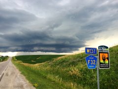
From the album: Summer 2016 Thunderstorms
Thunderstorm structure near Westphalia, Iowa. July 7th, 2016.