Quincy
-
Posts
6,220 -
Joined
-
Last visited
Content Type
Profiles
Blogs
Forums
American Weather
Media Demo
Store
Gallery
Everything posted by Quincy
-
As the calendar passes deeper into June, there is typically a steady drop-off in the frequency of severe weather threats across the U.S. Last year featured a grand finale to the severe weather season with a fairly significant sequence or tornado events across portions of the north-central U.S. from June 16th to 18th. While this year will likely not see quite an intense show as June 2014, there could very well still be some respectable severe activity with tornadoes. Mid-June of this year has been on the radar, so to speak, for quite some time. While there are still some model differences, it would appear that at least a couple of days between Thursday, June 18th and Sunday, June 21st should feature at least localized severe weather events. Note that there is some isolated potential before June 18th, this article will focus more so on the 18th onward. With it only being the 15th and plenty of time for forecasts to change, it is too soon to get into specifics. There are at least two main ingredients that would appear to favor severe weather, more-so, perhaps, than the U.S. has seen over the past week or so. Strong to possibly extreme instability is projected to be in place. Both the GFS and Euro show sizable areas of of 3000+ J/kg MLCAPE. The upper level flow is shifting toward a more zonal pattern, at least in the larger scale. An increasingly tight height gradient is likely from the central/northern Plains into portions of the Midwest by the end of the week and into the weekend. This is expected to result in a stronger component to the winds in the upper levels. The result is favorable forcing aloft and enhanced wind shear with any shortwave energy that ejects through. There are always caveats and red flags. While there may be more severe weather ingredients to work with, the overlap of those parameters may be relatively small. For example, while 500mb flow may be in excess of 50 knots for a time during this period, the best instability will almost certainly remain displaced well to the south and east. This in itself should tend to favor a more localized severe weather risk. Nonetheless, the Euro and especially the GFS progs over the past several runs highlight(ed) the period in and around June 18th to 21st. The potential exists for severe weather, possibly significant, including tornadoes somewhere in the region between the northern half of the Plains to the western Great Lakes. At the very least, some high CAPE/low shear setups are likely. The questions will become, how large can the threat zones extend and will some of the more impressive shear overlap with stronger instability? Take a look at some forecast soundings for this weekend if you want some severe weather eye candy. It is silly to take these progs too seriously at this point, so we will have to wait and see how the forecasts evolve. A broad geographical area is highlighted here and it will not be until the short-term that exact threat zones can be confidently identified. Nonetheless, at least one or two solid chasing days are predicted between Thursday and Sunday. If you are willing to travel or on a chasecation, there is reason to be cautiously optimistic about the storm chase potential coming up.
-

Central/Western Medium-Long Range Discussion
Quincy replied to andyhb's topic in Central/Western States
Still have eyes on this period. Verbatim, the 12/10 Euro shows bonafide threats days 8, 9 and 10. Would like to see more model consistency, especially once we get inside of 7 days. -
Central/Western Medium-Long Range Discussion
Quincy replied to andyhb's topic in Central/Western States
Details aside, there's at least some fair model support of some type of severe threat in the central/northern Plains to upper Midwest between June 16-20. The GFS, at varying degrees, has shown this threat in different capacities. Some runs showed a string of impressive days. The Euro has showed at least subtle signs, along with the ensembles. The latest Euro weeklies look a bit washed out in the mean, but the control run was a bit more dynamic up north. -
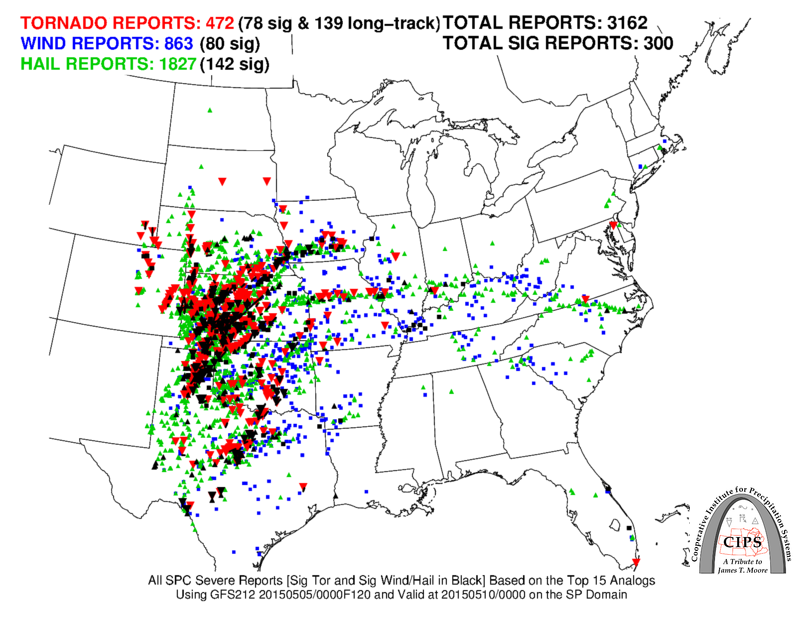
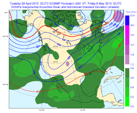
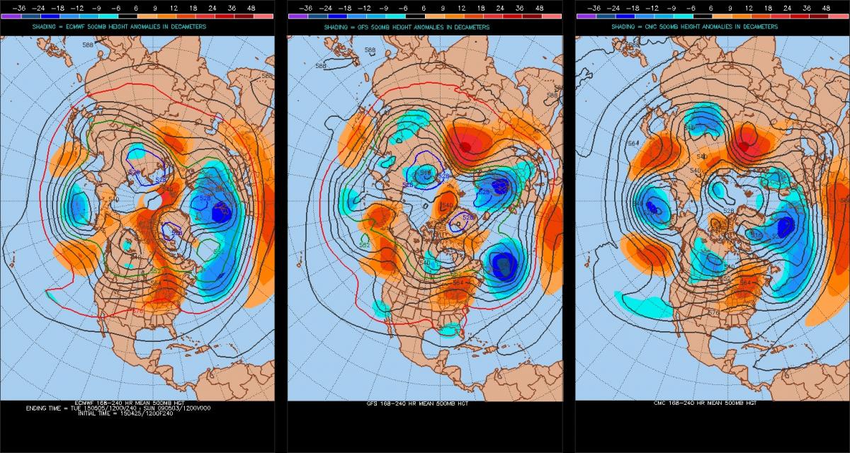
Recapping May: On the heels of a relatively active month for severe weather and tornadoes in April, May 2015 continued the pace. Although the month started slow with no tornadoes for the first two days and only a handful through the 5th, the greatest single day tornado event of 2015 occurred on May 6th. This was actually expected to be proceeded by a much more significant event on the 9th, but the former won out with 59 tornado reports, as the 9th did not fully live up to the hype/potential*. The first third of May paced at a somewhat above average count of tornadoes. Steady tornado events continued fairly regularly through the middle and latter portion of the month. Although there was no “defining” tornado outbreak after May 10th, there were multiple instances of picturesque tornadoes. While the previous forecast for May hinged on a near-average month, it looks like the period will end up at least slightly above average. The analog May of 1991 turned out to be the best fit among the four analogs from the 1990s. It was also the most active one of those four. The very persistent troughing across the Inter-mountain West to High Plains was well-indicated in both the forecast ensembles and analog data. Long-range forecasts may not always work out that well, but in this case, the verification speaks for itself. Only four days in the month reported no tornadoes, 5/1, 5/2, 5/12 and 5/31**, which includes an 18-day streak of reported tornadoes from the 13th to 30th. To quickly touch on the Plains long-term drought, it has been reduced significantly. Consistent bouts of heavy rain and convective activity have eliminated most of the drought area in the central to southern Plains. It now covers just a fraction of an area that it had before. In terms of tornado activity, the moisture transport northward has boosted the storm potential, but in a way, has also hampered the ability to easily storm chase. Without much EML (elevated mixed layer) influence this May and a tendency for storms to congeal into MCSs (mesoscale convective systems), countless tornadoes have been produced by high-precipitation supercells. Many of those tornadoes were rain-wrapped and/or difficult to see. Portions of Oklahoma reported a record-breaking 20 inches of more of rainfall in the month of May this year. A large portion of the southern Plains came in with precipitation anomalies of +8 inches or more for the month. That essentially means an extra two to three months worth of rain fell, if not more. This has caused major flooding in much of the region. June 1st through 10th: A general continuation of the recent pattern should continue through at least the first week of June. While the month begins with ridging across the southern Plains, the short-range models and global models alike are in strong forecast agreement with the upper level pattern. A trough is progged to dig into the West Coast with ripples of shortwave energy swinging into the central/northern Plains from June 1-3. Even though neither one of those three days appears particularly significant in terms of tornado potential, multiple severe reports, including tornadoes, should occur each day. After that, the parent trough is expected to continue digging and beyond that is where the forecast gets a little bit tricky. When looking back at the ensemble forecasts, the models had a ridge bias and did not really pick up on the trough becoming as amplified as it may. (For example, the most recent run, May 28th, of the Euro Weeklies looks much different for the second half of the first week of June, in comparison to the May 31st Euro ensemble run, which is more amplified) The trough could also become cutoff as some model projections indicate. The current expectation is that the trough axis may be just a little bit too far west to favor an outbreak-type severe setup in the Plains. With that said, whether the trough eventually ejects east to cause a significant event, or rather just a string of steady days (much like April and May of this year), there should be fairly consistent tornado threats through about the 7th or 8th of June. Rounding out the period, whatever is left of negative height anomalies in the West should relax to near climatology. Verdict: Somewhat above average tornado activity between June 1st and 10th. Fairly consistent bouts of severe weather, including tornadoes, are expected through the first week of June. Much like the previous six to eight weeks, while there may not be a higher-end severe setup on any particular day, tornado reports should be observed on most of these days. June 11th through 30th: Fighting with climatology and the computer model forecasts, there is only so long that relatively amplified troughing can dominate the pattern across the western half of the U.S. Starting with analog guidance, the results are fairly mixed. The general pattern assessed in the top four analogs (based off of GEFS 8-14 day prog from 00z 5/31 and extending out 20 days) is characterized as featuring ridging across the western U.S. to central/southern Plains and some troughing across the Great Lakes. It sounds a bit like what happened to start 2015. However, the individual four analogs (based on early June 2015 forecasts) diverge greatly in the period 10 to 20 days following. The 1991 analog, which was a strong match to May 2015, continues to show up. That June featured slightly below average tornado counts. Another analog that was also mentioned in the May 2015 tornado forecast is 1990. This one also shows up for the month of June and that particular month was well above average in terms of tornadoes. On the flip side, the other two analogs showed well below average tornado counts. The expected pattern to start June 2015 resembles late June 2006. That June finished fairly quiet and was followed up by one of the quietest months of July on record in terms of tornado activity. The final GEFS-based analog is 2002. That June was even quieter than 2006 and July of that year was also well below average for tornadoes. What can be made out of these mixed signals? Based on persistence and trends observed so far this spring, the computer forecast models have generally erred on the side of too much ridging occurring too quickly in a long-range forecast. It is inevitable that ridging will eventually prevail, but that does not entirely shut off the tornado season. In fact, it is very possible, if not probable, that troughing across the Great Lakes and/or Northeast could enhance the threat of severe weather from the Midwest into the Ohio Valley. A northwest flow regime tends to favor tornadoes in that region, especially the Ohio Valley. The expectation with this forecast is that mid-June should feature decent tornado potential, but that late June may not be as active. All four of the analogs above were eventually followed by a sharp drop-off in the tornado season, whether that came in late June or July. Also, one cannot forget June 16-18, 2014, in which an otherwise quiet tornado season become extremely active seemingly out of nowhere. Moisture return cannot be overlooked and this sets June 2015 apart from recent months of June. The soil moisture content across much of the Plains is much higher than it has been in at least two to three years. The period from May 1-29, 2015 featured slightly to somewhat above average soil moisture content from the Southwest into most of the Plains. This available moisture alone would tend to favor tornadoes, even if upper air and kinematic support are marginal. If the jet stream can stay active and provide enhanced flow aloft, a setup like mid-June 2014 could be possible sometime in June 2015. If such a setup did occur, available moisture would probably not be a concern at all. The bigger question becomes, can the Plains and Midwest eventually see more EML influence? That may be the difference between another “climo month,” versus a more memorable month for tornadoes. So far in 2015, it has been an active tornado season in two areas. One lies from north Texas/Red River Valley into central Oklahoma. The other is across the central to southern High Plains. Looking ahead to June 2015, early June features tornado prospects from the central/northern High Plains eastward into the Dakotas and Nebraska. Later in June, signs point toward Siouxland eastward through the Midwest and into portions of the lower Great Lakes/Ohio Valley. Verdict: Near to slightly average tornado activity between June 11th and 30th. June 1-10 forecast: Somewhat above average tornado counts in the U.S. June 11-20 forecast: Near average tornado counts in the U.S. June 21-30 forecast: Slightly below average tornado counts in the U.S. June 2015 tornado estimate: 255 tornadoes in the U.S. (slightly above average) *As has been the case many times this year, morning convective activity and MCS dominance have mitigated the frequency of discrete supercells. **This is subject to change as it may take a day or two for official reports to come in for May 31st.
-
Central/Western Medium-Long Range Discussion
Quincy replied to andyhb's topic in Central/Western States
The 00z Euro depiction of a modest trough moving into the Pacific Northwest to start June is supported by the EC ensembles. It's a ways out there, but verbatim would feature at least some severe potential from the central/northern Plains into the Upper Midwest. Worth watching I'd say in an otherwise increasingly meh pattern to finish May and prospects of stronger central US ridging deeper into June. -
Central/Western Medium-Long Range Discussion
Quincy replied to andyhb's topic in Central/Western States
The day 8-14 GEFS mean continues to look mildly interesting with at least modest western troughing. However, the new Euro weeklies are the kiss of death with a mega ridging building across the central US after June 6/7. I'm not sure how much stock I'll put into that projection, but something to watch in later ensemble runs. -
Central/Western Medium-Long Range Discussion
Quincy replied to andyhb's topic in Central/Western States
Euro weeklies should be out by 8pm eastern time M/Th on WxBell. -
The relatively active month of May looks to heat up again in the coming days. After a lot of severe thunderstorm activity last week, the first few days of this week have been on the quieter side. I am looking ahead to three days in particular for the next notable severe weather threats. Sleeper Thursday: This day has not been on the radar for most, but offers some potential, even if it is lower-end and in a relatively small area. I am focused on western Texas for isolated supercell/severe potential late Thursday afternoon into the evening hours. A small perturbation/vorticity lobe is modeled to pivot from eastern New Mexico into western Texas late Thursday. At the surface, modest daytime heating will likely result in an area of 1000-2000 J/kg SBCAPE, coupled with approximately 30 knots of 0-6km shear. Although the shear is somewhat marginal for supercell potential and the aerial extent of overlapping parameters is small, the higher resolution models do favor clusters of storms developing in this area. Some red flags include weaker winds aloft and storm mode/coverage, but an increasing low-level jet and backing winds around 00z may provide a small window for tornado development. What gets my attention about this event is that it is under the radar and in favorable chase terrain. I do not expect a lot of people to be out and the High Plains have featured several beautiful structure and tornado events this season, so I am not sure I can pass it up. Worst case, I would bail and head north, to get into closer position for Friday. Localized outbreak on Friday: The model guidance continues to show a strong signal for a severe weather on Friday, with an increased tornado potential across portions of the central Plains. Due to the models speeding up the system just a bit, more forcing and a favorably placed, developing surface low, Friday will probably feature the greatest potential in the otherwise multi-day threat. With the surface low moving into the central High Plains Friday afternoon, the models show strong instability developing across Kansas and Nebraska. The focus appears to be Nebraska, where multiple boundaries/fronts will locally enhance a tornado threat. The warm front is an obvious focus point, as it lifts through Nebraska late in the day. Moving toward late afternoon, the 4km NAM fires a line of discrete storms along a dryline, which will advance eastward through Nebraska and adjacent Kansas ahead of the developing surface low. Look for severe storms along this line, with an isolated to scattered tornado threat. This may extend as far south as sections of north-central Kansas. Along the warm front, the focus narrows in closer to the surface low and warm front/dryline intersection. I would watch the first or second cell closest to that point for a tornado threat. Aside from at least 2000-3000 J/kg SBCAPE (NAM is more like 3000-4000 J/kg), 35-45 knots of 0-6km shear (a bit higher via NAM) and favorable forcing for ascent all favor this severe threat. I imagine that the threat level will be upgraded to Moderate Risk by the Storm Prediction Center (SPC). What makes the threat here a bit more robust than some previous days is that we are not seeing a strong signal of convective debris or MCS activity overturning the atmosphere prior to peak heat. If there should be any convection in the morning, it would likely be limited in coverage, and outflow from that activity may only serve to further enhance the threat by leaving additional boundaries in place. Another quick note is that depending on how wrapped up the surface low becomes, the threat may punch northward into southern portions of South Dakota, especially into Friday evening. It is hard to really outline any significant red flags for Friday. There is the question of storm coverage, but a higher-end event in this case is actually favored when storms are more isolated. Precipitable water values are also expected to be lower than some recent events, so that further mitigated an MCS threat. I suppose there could be storm mergers and some messy storm mode eventually, but all in all, I think this is a bonafide threat and certainly a day to get out and chase. Messy mayhem on Saturday: The setup, overall, has a lot of similarities to last Saturday. It is likely that some junk convection and MCS activity in the morning will mitigate the threat. Also, the mid to upper level flow looks rather southerly, which is not ideal, as forecast soundings show veer-back-veer issues. With that said, if there are pockets of moderate instability, as the models indicate, there should still be corridors of an enhanced severe threat. This includes tornadoes, as 0-6km shear looks to be at least 40-50 knots and probably higher across some western areas of the threat zone. The red flags win out here, but there is time for this to change. In terms of chase potential, it will take some patience and strategy. Even last Saturday did result in clusters of tornadoes. With this threat being furthest out and potentially disappointing, I will not spend too much time focusing on it at this point. Of course, trends will be monitored and the threat will continued to be monitored.
-
Central/Western Medium-Long Range Discussion
Quincy replied to andyhb's topic in Central/Western States
One thing I've noticed too, is that in the long range, particularly >15 days out, the ensembles have consistently "changed" the pattern too quick. First we were supposed to get into ridging in the East in April. Eventually it did happen, but it kept getting pushed back. Now we're been seeing this "death ridge" keep getting pushed back further and further. Question is, when does the pattern give away to climo? We won't see these deep troughs in the West last forever. It looks like most, if not all of the rest of May holds potential with the overall, larger-scale pattern. -
Central/Western Medium-Long Range Discussion
Quincy replied to andyhb's topic in Central/Western States
If the lower analog domain is used for Saturday, it shows one of those high-end matches that we saw last week. Either way, a consistent signal of significant potential, if the red flags and limiting factors don't win out. -
Central/Western Medium-Long Range Discussion
Quincy replied to andyhb's topic in Central/Western States
A nicely active May pattern for sure. One that we haven't seen the likes of in at least a few years. The 1991 analog isn't working out too bad at all. I'm holding my breath about getting too amped up for a possible higher-end event, but it appears likely that anyone who doesn't mind a bit of traveling should have three solid chase days FRI-SUN. I like the challenge too. A lot learned from last week. Shifting targets. Evening surprises. Etc. Keeps it interesting and forces more use of meteorology skills than just relying on "modelology". -
As the pattern over North America shifts, an extended period of potential severe thunderstorms targets the central U.S. Although this update covers May 6-10, thunderstorms are ongoing today (May 5th) and were prevalent in prior days as well. The difference here is that we are gradually starting to see more and more potentially potent setups on the horizon. Wednesday, May 6th: This day has been on the radar for a while and things are coming into somewhat better focus. As shortwave energy pivots from the High Plains to central/northern Plains on Wednesday, an area of surface low pressure will develop. With more forcing in place than prior days, that alone signals an enhanced severe weather threat. — By Wednesday afternoon, a portion of the surface low should be crossing over from far eastern Colorado into western Kansas. The strongest forcing should reside from northwestern Oklahoma into central Kansas. However, the greatest instability will likely be displaced further south from central Oklahoma down into north Texas. Partial to considerable cloud-cover will tend to limit the amount of destabilization that takes place. That combined with modest flow at 500mb, progged to be on the order of about 35 to 45 knots, will tend to limit the extent of the severe weather potential. The surface low itself is also a bit elongated. If it were more concentrated and also deeper, that would signal a greater severe thunderstorm potential. Nonetheless, with a tongue of 1,000 to 2,000+ J/kg CAPE, favorable speed and directional shear, and some forcing aloft should favor at least scattered severe thunderstorms by mid to late afternoon. — In terms of severe threats and the areas to watch… It comes down to northwestern Oklahoma into central Kansas for what should be the greatest severe threat. More isolated severe storms are still possible along a dryline down into western and central Texas. Large hail, perhaps very large in a couple of storms, appears to be the most significant risk. Damaging winds will be possible, especially into the overnight as storms may tend to merge into lines. There is a tornado threat, which should be maximized during the early evening hours, as the low level jet ramps up. As has been the case many times this year, while there is an evident tornado threat, the intensity and duration of any tornadic storms will be dampened somewhat by the limiting factors mentioned above. There is a fairly good likliehood that multiple tornadoes (but not a major outbreak) will be reported late Wednesday afternoon into Wednesday evening. Thursday into Friday, May 7th and 8th, also provide some severe weather threat, but in a more isolated and sporadic nature. Upper level heights should remain fairly neutral through the period with no significant forcing noted in the models. Each day is likely to feature moderate instability and at least marginally supportive wind shear for supercell thunderstorms. The corridor for this period should be narrowed in on the Texas panhandle, portions of interior Texas and into Oklahoma. While some severe threat may nudge into portions of Kansas, the greatest (still somewhat limited) threat should hang back further south. Each day, storms may produce large hail with some damaging winds and a few tornadoes. — Each day, watch for a few things: First, where is the greatest instability? If cloud-cover and convective debris are limited during the morning, expect a somewhat enhanced severe weather threat during the afternoon. Also, look for any outflow or other mesoscale boundaries that can be the focal point(s) for storm development. Finally, notice any upper level perturbations, even if seemingly minor, as they could provide just enough forcing to locally increase the severe threat. Saturday, May 9th has the potential, but the keyword is potential, to be a significant severe weather outbreak with numerous tornadoes. The overall pattern is favorable, as a trough swinging from the Four Corners region to eastern Colorado/New Mexico by late-day will provide ample forcing from the High Plains into portions of the central to southern Plains. Caution must be applied when looking at the analogs, but there is a fairly strong signal from the analogs that favors widespread severe thunderstorms and at least isolated significant severe events, including strong and/or long-track tornadoes. — Now, even though some major events show up in the analogs, there are a few limiting factors that will not favor a high-end outbreak. While the flow and forcing increase aloft, 70-80 knots at 300mb and 50-60 knots at 500mb will fall well short of an event such as 4/14/12, which showed up as a GFS-based analog. As far as instability, even though moderate CAPE values are predicted, we’re not looking at strong to extreme instability. There seems to be a common theme, with this week especially, that the atmosphere is not quite taking full advantage, resulting in a less extreme “than possible” setup. — With all of this said, even if the timing is not exactly right, and the timing looks pretty favorable right now, severe thunderstorms are strongly favored on Saturday. What will be the difference between a low-end event and a more significant outbreak will come down to mesoscale details. What also favors severe weather on Saturday is how the models, overall, have been in very good agreement with the general setup on Saturday for quite some time. The focus on Saturday ranges from north Texas through much of Oklahoma and Kansas, to perhaps as far north as portions of Nebraska. All severe weather modes are anticipated, with an enhanced risk of tornadoes. Sunday, May 10th is a bit further out there, but yet another severe day is quite possible. Details are a bit more muddled, as the evolution of Saturday will have a sizeable impact on what transpires on Sunday. The threat zone inches somewhat east, ranging from portions of Texas up through central and eastern Oklahoma, eastern Kansas and perhaps into portions of Missouri and Arkansas. In summary, expect severe weather threats for the rest of this week and likely through most of this weekend across the central U.S. At least a few severe thunderstorms are expected each day, with scattered severe storms on Wednesday and perhaps a mode widespread and significant event on Saturday. Tornadoes are possible each day, but the day with the likelihood for the most tornadoes is also Saturday. In terms of storm chasing, there should be many quality opportunities to get out in prime real estate, from the High Plains into the Plains west of I-35. With the threats covering a long period over some similar areas, it may be worth while to hunker down and start thinking of possible targets or even just places to stay (if you’re planning a multi-day trip). Without giving too much away, and since details may change, I tend to favor a corridor from the Texas panhandle into southwest and central Kansas. Climatology also favors this zone for the greatest severe weather threat and trends this year have kept the dryline a bit further west, mainly across these areas, during most events.
-
Central/Western Medium-Long Range Discussion
Quincy replied to andyhb's topic in Central/Western States
Like many of the days this week, we may not have a really clear idea on the potential until the near-term, given so many things that could throw a wrench in it. Although the potential is there and with a fairly high ceiling, if things can line up. 00z GFS-based analogs showing a strong signal. Some of the matches were some pretty big days, like 5/23/08 and 4/14/12. Taken with a grain of salt:
-
Central/Western Medium-Long Range Discussion
Quincy replied to andyhb's topic in Central/Western States
It's especially odd since they have 15% probs now to outline in the day 4-8 period (was only 30% in the past). It's perplexing since the Euro and GFS have been in very good overall agreement through Saturday. -
Central/Western Medium-Long Range Discussion
Quincy replied to andyhb's topic in Central/Western States
It's been mentioned, but all of the beneficial rain this week should take a big knock out of the regional drought too. Not to mention that bodes well for available moisture later this month. -
Central/Western Medium-Long Range Discussion
Quincy replied to andyhb's topic in Central/Western States
I know better than to get too excited, but quietly the trends for next weekend have gotten better. Can't help but like the look of the Euro ensemble mean at 168h. I'm sure it will continue to evolve and we need to get through this mid-week mess first. -
The final few days of April finished on the quiet side in terms of severe and that continued into May 1st. With that said, a larger-scale pattern change is likely to be accompanied by multiple threats of severe weather in the coming days. Saturday 5/2: Not seeing anything major here. Although we should finally see some modest instability up into the central Plains, dew-points are only expected to rise into the upper 40s to lower 50s across the area with some weak forcing during the evening. One plus is that wind shear will be supportive of supercell structures, assuming other variables line up. Verdict: A few, rogue severe thunderstorms are possible from late afternoon into the evening, but even those may only be marginally severe. The focus is on the central Plains Sunday 5/3: The setup looks slightly better than Saturday, but that does not say much. A larger area can expect modest to moderate instability, but the drawback here is near-neutral height tendencies. Upper level progs show little focused area of forcing. The only thing that looks somewhat interesting is a surface low forming near the Colorado/Kansas border. This could narrow the focus on some isolated severe thunderstorms to the Texas and Oklahoma panhandles, but even here the prospects are not terribly exciting. If there is enough of a trigger, a few isolated strong to severe storms could also initiate up into the central Plains and as far east as the upper Midwest. Wind shear is questionable throughout the regions outlined. Verdict: Isolated severe thunderstorms are possible anywhere from the southern High Plains into the central Plains and upper Midwest. If there is one area to focus in on, it might be just ahead of a surface low, in the vicinity of the Texas/Oklahoma panhandles. While the ceiling may be somewhat higher than Saturday, storm coverage and intensity is not expected to be particularly impressive. Monday 5/4: This looks like the beginning of what may be an extended period of active weather. A trough should begin digging into the West Coast, with some modest height falls reaching the High Plains. Moisture will likely be a positive and negative thing here. Although dew-points should reach the upper 50s to lower 60s at a minimum, cloud-cover, convective debris and increasing precipitable water values throw a wrench in the severe storm potential. Likewise, wind shear is not expected to be terribly impressive either. What may end up ultimately happening is that a few pockets of greater instability could lead to a few supercells reaching severe limits. Verdict: Mixed signals somewhat hamper the severe potential, but it would appear probable that at least a few isolated to widely scattered severe thunderstorms could develop from the Texas/Oklahoma panhandles into Kansas. Tuesday 5/5 through Thursday 5/7: The Euro and GFS are actually in very good agreement overall through the period with the general pattern. The West Coast trough continues to dig and a piece of energy swings through from the High Plains on Tuesday into the central Plains on Wednesday. Tuesday looks muddled at best with meager instability and limited kinematic support. Wednesday may offer the best potential, if things line up. Shortwave energy should be pivoting into the central Plains, along with a surface low, but that low looks awfully elongated. The instability setup may suffer too, from limited instability and on-going clouds/sub-severe storms. With that said, a low level-jet should be cranking with both the Euro and GFS suggesting at least 40-50+ knot winds at 850mb. Thursday becomes a bit more unclear, despite continued model agreement. Storms may be ongoing Thursday morning, based on current trends, and the models seem, perhaps, a bit overdone with instability in the warm sector. Even so, wind shear looks to slacken off, which could be another factor to limit the severe threat. Timing is yet another concern, as a faster evolution could really hinder the Thursday risk, whereas a slower scenario might be better. Verdict: Some isolated to scattered severe thunderstorm potential each day, but details are still unclear. Wednesday may offer the greatest potential with Thursday being a wild card. The worst case is that this upcoming week, there are just a few severe thunderstorms, but enough of a threat to track for a few days in a row. The best case is that things come together for one to possibly two decent chase days.
-
The feedback is appreciated! Violent tornadoes in Florida are actually quite rare, even though they do see a large number of weak tornadoes on a fairly regular basis. United States Tornadoes has another graphic showing violent tornadoes over a similar, but somewhat longer time scale:
-
Central/Western Medium-Long Range Discussion
Quincy replied to andyhb's topic in Central/Western States
Some missing pieces (in terms of severe) for the middle of next week and it's a shame. It looks like an active period may result in more heavy rainfall than anything. Although I would suspect at least a slight risk for severe thunderstorms during a couple of those days. The PW values are progged to be on the order of 2+ SDs across much of the Plains, another signal of the heavy rain potential. The Euro shows a general 2-4 inch rainfall event by the end of the week for much of the area. Considering portions of northern Texas have already seen their fair share of rain as of late, it's not's exactly welcome, at least not so soon. Although longer term trends still indicate some persistent drought conditions. -
Central/Western Medium-Long Range Discussion
Quincy replied to andyhb's topic in Central/Western States
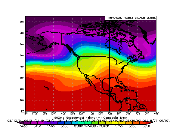
I think there are some encouraging signs. Here is the 500mb mean analog pattern for mid to late May, using the top 5 analogs from the GEFS 6-10 day forecast. It actually lines up very closely to the 00/30 Euro Weeklies projection for the time period, only slightly further east (even better) with the ridge axis. I whipped together a quick May tornado forecast here. A little bit more cautious of an outlook than for April, but I wouldn't be surprised if there was a bigger event somewhere in the second half of May.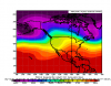
-
The April tornado forecast was a trial run and a lot has been learned since it was made. After some success with that forecast, I will be incorporating a lot more statistical analysis (analog data) into coming up with a forecast for the month of May. Quickly recapping April: Overall, April was a fairly steady month for tornado reports across the U.S., with 21 out of 30 days reporting tornadoes. April 1-9 was very active, including a notable, early season EF-4 tornado in northern Illinois. April 10-18 was relatively inactive, but had tornadoes reported in all but two of those days. April 19-27 was rather active, but no single day featured a major or significant outbreak. Most of the tornadoes in the month were EF-1 or weaker, although the April 9th EF-4 was an exception. Preliminary tornado counts indicate that the month was near to slightly below average in tornado activity. The prior forecast issued on March 31st predicted slightly above average tornado counts. Once the numbers become official, I will get into more detail with comparing the forecast vs. actual. Before we get into May, there are some things to consider with the current state of the U.S. Although a long-term drought continues for much of the Plains, heavy rainfall throughout April reduced drought conditions considerably across portions of Oklahoma and Texas. This is critical, because relative tornado inactivity during the first half of spring 2014 across the Plains was at least partially attributed to a lack of available moisture. When we think about creating environments that support tornadoes, moisture is key and that moisture source can originate in Texas. Yes, the Gulf of Mexico is another player, but that moisture must also be able to track hundreds of miles inland, across the big state of Texas. Additionally, the overall atmospheric pattern has shifted somewhat, as although there has been continued troughiness across eastern Canada and the Northeast, we are seeing a trend toward more ridging developing. This will have many implications on how the tornado season evolves into May. With less blocking across northeast Canada toward the North Pole, that should tend to favor positive height tendencies as well. (Not to mention seasonality helps with that as well) For this outlook, the focus will be split into two portions. May 1-10 and May 11-31. I will still include breaking the month down into thirds at the end of the outlook, but keep in mind that specifics beyond May 10th lack the confidence needed to get into extreme detail in that time period. May is also a potentially volatile month, as one outbreak or even one day for tornadoes can effectively skew the big picture. It would be difficult to nearly impossible to predict any such outbreak more than 10 days in advance. The point of this outlook is to look at May as a whole. May 1st through 10th: After a quiet finish to the tornado season in April, the first few days of May look to continue that theme. This should not last long, though, as both the operational and ensemble forecast models are in strong agreement with the expected pattern. On paper, it looks encouraging for severe weather prospects. An upper level trough and surface low should exit the New England area may May 3rd, leaving the Lower 48 with a relatively zonal pattern, at least for a short-time. Downstream ridging across the East should give way to a digging trough across the West Coast by May 4th to 5th. With some blocking across eastern Canada, we are looking at western U.S. trough that will persist for several days, with potentially multiple impulses rotating around from the Intermountain West into the Plains. This could ultimately evolve in many ways. At this point, the most probable scenario would appear to be two to three, perhaps four, days that are conducive for minor to moderate severe weather events, including tornadoes. I would not want to write off the potential for a big event just yet, but it seems more likely that we will have a series of smaller events, kind of how April panned out. What will be working in the favor of severe weather will be the bonus of a better moisture source across the southern Plains and moderate to strong instability ahead of approaching shortwaves. It is the details that get somewhat muddled out, with the amount of clearing/destablization, storm mode, locally backed winds, etc. Essentially, the pattern looks favorable for severe weather and tornadoes, particularly between May 5th and 8th. As mentioned before, maybe only two of those days wind up decent for severe, but if the pattern lines up just right, there could be multiple tornadoes each day. Verdict: Near average tornado activity between May 1st and 10th. The period should begin quiet, but then see multiple days with at least modest tornado activity. The period may close out with a couple of quiet days as the pattern trends more zonal, assuming the model projections are correct. May 11st through 31st: I have put a lot of time into assessing analog data for this period and not so heavily relying upon forecast model ensembles, as was the case with the April tornado outlook. What has been most alarming lately is that the longer-range models have really struggled beyond day 10 over the past several weeks and have often showed little to no skill in the period of days 15 to 30. This means that the models have flip-flopped back and forth, giving little meaningful insight to what might lie ahead. Now, I am not totally discounting the models here. Sometimes they can struggle during a large scale pattern change, much like what we may be seeing into May. I put a fair amount of stock into the European ensembles/weeklies, but I think taking a look at the past will help shed some light on what might happen in the future. To come up with analogs, I have looked at two things in particular. First, I assessed the short-term model analogs for May 1-2. Secondly, I looked at the day 6-10 ensemble predictions from the GEFS and those analogs. There was some overlap and plenty of similarities to note. In the broad scheme, the analogs began with the western troughing/eastern ridging that we are expecting to see into the first week of May. The analogs are then in strong agreement with positive height anomalies along and east of the Rockies from the 2nd week of May, pretty much through the entire month. After gaining visibility to the latest 00/30 Euro Weeklies, pretty much the same is the case here. That only increases confidence in this forecast. I pretty much disregarded the CFS entirely for this outlook, as its members are all over the place for May and as an ensemble system, has not had a good track record as of late. Going back to the ridge axis, that is the key thing to consider. The indications, in general, point toward a mean ridge axis setting up somewhere between the Missouri River and the Mississippi River. The latter, or a further east ridge axis, would be more supportive of tornadoes, allowing for troughs to dig a bit further south and west into the Plains. Even the former would be encouraging, as it would tend to favor High Plains activity. That region has not had a great chase season in a while. Based on the reports, it appears as if 2010 was the last solid year there and 2008 was decent too, particularly across western Kansas. Either way, since we are looking at a broad period here and kind of splitting hairs, there is nothing necessarily stopping from a rogue, deep trough to swing through, although it would appear that if that was going to happen, it would tend to favor late May over mid-May. As a result, I am leaning toward a somewhat more active end to May, even though I do expect a fair amount of activity in the middle of the month as well. (When I say fair amount of activity, I expect several days with scattered severe reports, again, in some ways similar to what April featured) Verdict: Near average tornado activity between May 11th and 31st. The middle of May holds some potential, but is forecast to feature slightly below average tornado reports. Into late May, there are some indications that tornado activity could rebound to near to slightly above average levels with more potential activity. When looking at some of the recent analogs (over the past 25 years), 3 out of 4 had slightly to moderately below average tornado counts in May. On the flip side, they tended to favor average to even very active months of June. Since May 2015 does not appear to be a particularly close match to any of those analogs, I would take that information with a grain of salt. If anything, it does give at least some additional confidence in the thinking that May could end more active and lead into another active June. I do not want to get ahead of myself here, so we will hold off on further discussion about June until the next monthly tornado forecast. May 1-10 forecast: Near average tornado counts in the U.S. May 11-20 forecast: Slightly below average tornado counts in the U.S. May 21-31 forecast: Near to slightly above average tornado counts in the U.S. May 2015 tornado estimate: 260 tornadoes in the U.S. (near to slightly below average) For those wondering, the top 5 analogs are as follows, beginning with the given date and extending out 20 days: 4/28/1994, 5/12/1991, 4/28/1957, 5/10/1993 and 5/18/1977, in that order. The “recent” analogs mentioned earlier in the post were 1990, 1991, 1993 and 1994.
-
Central/Western Medium-Long Range Discussion
Quincy replied to andyhb's topic in Central/Western States
Have to admit I'm getting a bit concerned. I'd much rather have an overall favorable pattern than a couple of days that may or may not produce. The trend with the ensembles has been to knock the flow relatively zonal, but with positive height anomalies and pushing the jet north later into May. Although the 00/30 EC ENS showed more West Coast troughing by day 15, the ensembles have had poor consistency and verification beyond day 10 over the past several weeks. If you believe the CFS, it also shows signs of death ridging by mid-May. Looking at some more data throughout today and after the Euro Weeklies come out, I'll be ready to put a May tornado outlook together. -
Central/Western Medium-Long Range Discussion
Quincy replied to andyhb's topic in Central/Western States
It's encouraging now to see this signal prevalent on a majority of the ensemble members, of both the Euro and GFS. Finer details are a long way from being resolved, but after a momentary break in the action, we could see severe threats begin to ramp up again. (I think there is some thunderstorm potential by this Sunday/Monday, but something more significant likely holds off until later next week or the weekend that follows)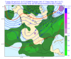
-
Central/Western Medium-Long Range Discussion
Quincy replied to andyhb's topic in Central/Western States
After being stuck in model fantasy land, now inside of 10 days we have model support and agreement of some ridging in the east. We'll see if this comes into fruition. If so, we could see some enhanced severe activity into early May.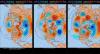
-
Central/Western Medium-Long Range Discussion
Quincy replied to andyhb's topic in Central/Western States
Say hello to the PAC ridge again ~April 15-19. It's been on the ensembles for quite some time. It's still a bit muddled how the pattern with respect to severe evolves after that, but at least it appears likely the ridging should break down fairly quickly.