Quincy
-
Posts
6,220 -
Joined
-
Last visited
Content Type
Profiles
Blogs
Forums
American Weather
Media Demo
Store
Gallery
Everything posted by Quincy
-

Central/Western Medium-Long Range Discussion
Quincy replied to andyhb's topic in Central/Western States
The 12z EPS is pretty awful, with Great Lakes troughing right through day 15. -
Central/Western Medium-Long Range Discussion
Quincy replied to andyhb's topic in Central/Western States
I actually looked closer at the data tonight and it's downright ugly. The weeklies show AOA 500mb heights over the central/southern Plains for 35 out of 36 days between 4/26 and 5/31. The CFS has all blue chiclets through May 3rd. (The CFS is not God, but it has support from other data) Overall synoptic pattern advertised on the GEFS/EPS over the next two weeks is not favorable. To be cautiously realistic, there is some potential for the pattern to amplify a bit around the last weekend in April, but even there, some ensembles suggest that we get some sort of cutoff low over the California region, which would not be very favorable either. Overall, the next two weeks, at least, look quiet. One cannot rule out one or two days that either overperform or come up on short notice, but aside from that, I'll go back to sleep as well. -
Central/Western Medium-Long Range Discussion
Quincy replied to andyhb's topic in Central/Western States
At least we should finally start backing out of the historic fire weather concerns and exceptional drought in the southern High Plains. The operational models and ensembles are in very good agreement for at least 0.5-1 inch of rain by Friday night over a broad area that has seen virtually no meaningful precipitation since last fall. -
Central/Western Medium-Long Range Discussion
Quincy replied to andyhb's topic in Central/Western States
Sounding climatology suggests that 60F dew-points would be high-end for the time of year. MAF sounding climo suggests a 55F dew would move into the 90th percentile, while lower 60s is the max for the 64+ year period of record. At AMA, 50F is already well above the 90th percentile, with almost no soundings eclipsing 60F dews in April. Remember that West Texas has a similar elevation to the CO/KS border region, as higher terrain does not necessitate higher dew-points as lower terrain areas. Dew-points in the mid and especially upper 50s would be sufficient. Mean mixing ratios of 11+ g/kg (which GFS shows) will get it done. With that said, I don't think there's any reason to believe this will be a major event, but it certainly has the ingredients for a respectable April event in the High Plains, assuming storms remain at least somewhat isolated. Let's keep an eye on it and see how moisture return looks. If it trends lower than it is now, then maybe we'll have a problem. At the very least. the setup should bring some much needed rain to the panhandle region, which has been plagued by a major drought and destructive fire season as of late. -
Central/Western Medium-Long Range Discussion
Quincy replied to andyhb's topic in Central/Western States
The models are converging and a severe weather event is appearing increasingly likely on Friday, particularly from eastern portions of the southern Plains into parts of Arkansas, Missouri and possibly Iowa. Models bring a seasonably strong surface cyclone from the central Plains Thursday night to a position in the lower Missouri Valley vicinity by Friday evening. Ahead of a cold front, a plume of low to mid-60s dew-points is favored in the warm sector likely covering much of Missouri, eastern Kansas, eastern Oklahoma, Arkansas and East Texas. This would support at least a narrow zone of moderate instability, i.e. CAPEs of at least 1000-2000 J/kg, particularly along areas from eastern Kansas, southward to East Texas, immediately ahead of the cold front. Due to cooling aloft, an upper level low approaches, convective initiation is expected during the afternoon with little to no capping, in a broad swath immediately ahead of the cold front and possibly in the open warm sector as well. It should be noted that the size of the warm sector is a bit of a question mark, leaving the greatest confidence to convection closer to the cold front. Areas displaced farther east may see more capping, along with less influence from the attendant upper level trough. More than adequate deep layer shear for severe thunderstorms is a given with a >70 knot jet streak rounding the base of the upper level trough. Probably the biggest issue limiting this from a more widespread tornado threat is the largely unidirectional wind fields in the mid and upper levels. Forecast soundings up and down the region from southern Iowa to East Texas show relatively straight hodographs in the 1-6km layer, with some subtle veer-back-veer signals as well. With that said, there is enlargement of 0-1km hodographs, as near-surface winds ahead of the southwesterly mid/upper level flow should be S to SSE in the warm sector. Take it with a grain of salt, but NAM forecast soundings in a wide area do show a bit of a sickle-shape in the 0-1km portion of the hodograph, but show kinks in the mid-levels. There may even be a tendency for winds to back a bit above 500mb, so the lack of a more veering-with-height throughout the column profile suggests there are some limiting factors in place in respect to tornado potential. There is some concern that convection may develop quickly over a broad area Friday afternoon with a tendency for storms to merge into line segments. Unlikely some recent severe weather events, mid-level lapse rates appear more modest, so large hail will probably be overshadowed more by the threat for damaging winds and isolated tornadoes. In terms of storm chasing potential, the threat one does not exactly look to fall over favorable terrain, but there is some silver lining. Assuming the model progs do not speed up the system, then eastern Kansas may get in on the action. Eastern Oklahoma and other points east are far from ideal. The Iowa vicinity is a bit more of a wildcard, depending on how the surface low evolves. If a more wound-up low moves across Iowa, there could certainly be a play near the surface low/triple point. If the low is more elongated, like some data suggests, then I would be concerned about limited instability and messier storm modes with northward extent. Mesoscale details can be ironed out as the event nears, but the general area surrounding the AR/KS/MO/OK border region seems to have the greatest likelihood for severe thunderstorms, near and just ahead of the cold front. Issues arise further north (Iowa) and it's unclear how convection may evolve farther south, away from stronger large-scale forcing (East Texas). Given the synoptic pattern, at least scattered severe reports (including all hazards of hail, tornado and wind) are likely. Storm mode expectations lead me to believe that the window for tornadic supercells and large hail may be relatively narrow, but wind fields suggest that brief tornadoes may remain a possibility later in convective evolution, even if storms consolidate into a line or line segments. Damaging wind could end up being the more widespread story, given the strength of the expected wind fields. -
Central/Western Medium-Long Range Discussion
Quincy replied to andyhb's topic in Central/Western States
This Thursday/Friday storm system is kind of funny. Instead of being upset or depressed with the following scenario, I actually take a moment to chuckle and move on. It's not worth it getting upset over a lousy pattern. Assuming the latest models are close to right, both the GFS and Euro take a <982mb low from west to east across Nebraska Thursday evening into the overnight. Despite such a strong surface cyclone so far north, the Euro struggles to bring 60F dew-points to the Kansas border by 00z Friday, while the GFS does manage to bring dews into the lower 60s as far north as Kansas City. All else put aside, if someone said that a deepening 982mb low was going to move across Nebraska in mid-April, the alarm bells would probably be going off for a potential severe weather event. Since temperatures aloft are going to be quite warm and low-level moisture will be lower-end for the setup, it's probable, if not likely, that no convection will initiate in the Plains on Thursday. Sure, the event is still several days out and if the low-levels improve a bit, there's still a shot at something conditional, but it looks like Thursday will probably be wasted. If that wasn't bad enough, Friday has better potential, but the warm sector will be relatively narrow, the best forcing becomes farther displaced from areas with more favorable buoyancy and most, if not all of the convection should initiate over "poor" terrain in the Arkansas/Missouri vicinity. Too slow for Thursday to be promising and probably too sloppy of a setup for a bigger event on Friday. It's also slowed down and shifted enough west that the corn belt region will likely be on the cooler side of the setup, rendering any severe threat close to zero there. The weekend looks like another trough over the eastern third of the U.S., but there are signs that the pattern gradually becomes more conducive for severe weather in the central states by the following week. That's not saying a lot given the calendar, but as it stands, it still looks like nothing major in the foreseeable future. We had snow yesterday and now the models show temperatures in the 90s to around 100F for parts of western Oklahoma on Thursday. -
MO/KS/AR/OK 2019-2020 Winter Wonderland Discussion
Quincy replied to JoMo's topic in Central/Western States
Daytime accumulating snow here in Oklahoma City. Pretty remarkable for April 7th. Still 26F at noon, despite an average high of 70F. According PSU e-WALL data, the temperature is 37F below average for 17z. -
Central/Western Medium-Long Range Discussion
Quincy replied to andyhb's topic in Central/Western States
Assuming the model prog is correct, it's just a messy setup with a cold front crashing south from Oklahoma. Soundings ahead of the front show a monster cap near the Red River and into East Texas, although that is less of a problem up into Arkansas near the warm front. In such a scenario, we'd probably see a big squall line with perhaps a few embedded supercellular elements, but definitely HP. I also don't like the looks of limited CAPE in the lowest 2-3km. So far this year, we've had no problem driving the EML eastward with impressive 700-500mb lapse rates (probably dry air punching farther east with the ongoing High Plains drought and cold intrusions from the north), but a lot of the setups so far have had limited low-level CAPE. I guess that's to be expected until we're later in the season and it's easier to get surface temperatures into the 80s. -
Central/Western Medium-Long Range Discussion
Quincy replied to andyhb's topic in Central/Western States
Severe thunderstorm prospects for the foreseeable future are quite bleak. The CFS has had a consistently quiet signal for the first two weeks of April, while this is supported by yesterday's Euro weeklies. The weeklies try to improve a bit around mid-April, only to reload the eastern U.S. trough around April week 3. A more favorable pattern is advertised for the last week of April, but model confidence decreases into this range. At the very least, climo favors increased activity around the end of April, even commonly in most years that were otherwise quiet. -
Central/Western Medium-Long Range Discussion
Quincy replied to andyhb's topic in Central/Western States
Severe prospects for Sunday through Tuesday are muddled, as neither day stands out, despite having a slow-moving trough moving from the Southwest into the southern Rockies. Sunday remains fairly conditional, but there does appear to be a narrow corridor, somewhere near the Red River Valley across the southern Plains, that could support an isolated supercell threat. Forcing remains the largest concern, but model forecast soundings are a little bit more aggressive with boundary layer heating in the afternoon. This may be enough to erode surface-based convective inhibition. A larger area is expected to see favorable deep layer shear and instability on Monday from Texas to eastern Kansas, but the issue here is that wind profiles show veer-back-veer signatures. Hodographs are somewhat elongated, but very messy looking. Mesoscale details may determine the scope and magnitude of any severe threat, although it does not look like a big day, any way you slice it. A sagging frontal boundary becomes increasingly parallel to the deep layer shear vectors by Tuesday, suggesting the potential for more of a squall line type feature, from the southern Plains into the Arklatex and lower Mississippi Valley region. While severe weather may not be widespread, as mentioned earlier, heavy rain will probably be the biggest story. There is not much hope for substantial rainfall over the High Plains, but areas from I-35 and points east have the highest probability of seeing above to well above average rainfall over the next 3-5 days. -
Central/Western Medium-Long Range Discussion
Quincy replied to andyhb's topic in Central/Western States
Sunday is very conditional and I don't like to pick apart soundings this far out, but just a few notes: Convective temperatures in the vicinity of the dryline bulge are in the mid-80s, while models show temperatures in the low to mid-70s. (Areas that do reach 80+ are on the dry side of the dryline) Forecast soundings show very little CAPE in the lowest 2km AGL, indicative of a capping inversion. Also, large scale forcing appears limited, with only very modest 12-hour 500mb height falls, in the ballpark of 10-20 meters. Regardless, we do appear to be rounding the bend and thunderstorm threats are increasing across the southern Plains. We should see several days with at least spotty severe reports over the next 5-7 days. At the very least, much-needed rainfall across the area should help ease some drought concerns, although there are signs that the bulk of the rainfall will stay closer to I-35 and points east, but we'll see. As some recent years have shown us, a pattern change can knock out a drought pretty darn quick. -
Not sure if it's accurate, but M40 just shot up to 70/70 on the latest ob. Seems suspect. Tupelo was 58/57 at the top of the hour, so that cluster is likely on a track just north of the warm front based on the current storm motion, at least in the short term.
-
Central/Western Medium-Long Range Discussion
Quincy replied to andyhb's topic in Central/Western States
I don't know about moisture recovery not being an issue with the upcoming systems. The 12z Euro looks awful tame now with 60F dews staying south of the Red River on Sunday and struggling to reach into Arkansas on Monday. The overall pattern is too messy, especially for March, given such a large trough over eastern North America. With relatively small systems reoccurring in a fast-flow pattern, there isn't much reason to believe there will be substantial moisture recovery. More of a robust south/southeasterly wind trajectory over the southern Plains/lower Mississippi Valley is needed than what is progged with the expected pattern. If it was later in the season, it wouldn't take as much to moisten the warm sector, but we're only in mid-March and next week doesn't look too promising. I wouldn't be overly concerned though, as it is barely meteorological spring and not even the spring equinox yet. I wouldn't rule out some spotty severe next week and maybe the evolution of one or two of the systems will improve, but it definitely does not look like an outbreak setup and doesn't even look like a scenario for anything impressive for mid-March standards. -
Central/Western Medium-Long Range Discussion
Quincy replied to andyhb's topic in Central/Western States
The 00z 3km NAM wasn't impressive at all, showing substantial cloud-cover ahead of the dryline with surface temperatures 5-10F shy of convective temperatures, even in the vicinity of a dryline bulge in the eastern Texas panhandle. Reflectivity progs concur with no convection. Meanwhile, the GFS came in a bit warmer in the western Oklahoma to central Kansas region, although still not quite robust enough for convection. I was intrigued to see the RGEM spit out convection in far southwestern Oklahoma between 21z Sun and 00z Mon. It makes sense based on what appears to be surface temperatures heating into the mid-70s in the presence of upper 50s to near 60F dew-points. I am still inclined to lean toward a non-event with cloud-cover mitigating surface heating (poor sfc-850mb lapse rates), despite favorable wind fields and nice looking thermodynamic profiles above 800mb. A highly conditional threat could still produce if surface heating improves, so I'd hold with a MRGL risk outlook for tonight's day 2 update. -
Central/Western Medium-Long Range Discussion
Quincy replied to andyhb's topic in Central/Western States
The main limiting factor appears to be the quality of the warm sector. As discussed above, only a narrow area around the southwestern Oklahoma vicinity is progged to have (somewhat) favorable low level moisture, along with at least a possibility of convective temperatures being approached. The issue is that even within NAM range (taken with a large grain of salt at 72hrs), only a very tiny area (1-3 counties) comes within a couple of degrees of convective temperatures. The 00z NAM also shows no convection along the dryline. In addition, the NAM, too, favors the idea of >75% cloud cover across areas east of the dryline in Oklahoma. Synoptically, Sunday resembles 2/28/12, however, the warm sector this weekend is significantly smaller and far less impressive. If we had a deeper trough, a la 2/23/07, better forcing and mid-level cooling would result in much greater certainty of convective initiation along the dryline. Even the evolution of the surface low is not entirely clear. The 12z ECMWF shows a 995mb low up near I-80 in central Nebraska at 00z Mon, while the operational NAM still shows a focused low over western Kansas at the same time. The 18z GFS was somewhere between, while the 21z SREF shows substantial variability, ranging from an OP NAM solution to a more elongated low over the mid-Missouri Valley/Siouxland. Once we get into higher resolution model range and the operational models have some time to converge on a solution, then confidence may increase. Right now, the severe threat appears fairly conditional and perhaps more than one would expect for such a scenario in early March. The ongoing drought and (expected) relatively meager warm sector don't help matters either. As stated in the previous reply, the forecast shear profile won't need much to take things off. The low level thermodynamics just need to be improved... -
Central/Western Medium-Long Range Discussion
Quincy replied to andyhb's topic in Central/Western States
Where are you seeing lower 70s on the GFS with upper 50s dew-points and minimal capping? That was my main point. -
Central/Western Medium-Long Range Discussion
Quincy replied to andyhb's topic in Central/Western States
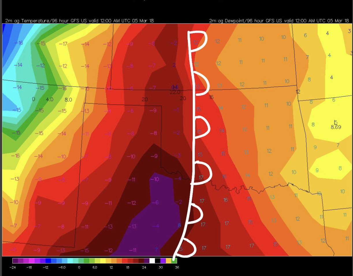
Regarding moisture... notice how the dryline surges east on the GFS, outrunning the greatest surface heating, leaving only a narrow sliver of favorable low-level temperatures and moisture. Even though progs are in the ballpark of 70/60 near the Red River, warming around 850mb results in a sizable capping inversion, especially south of the KS/OK border. For reference, readings are in Celsius on this map, where 20C = 68F.
-
Central/Western Medium-Long Range Discussion
Quincy replied to andyhb's topic in Central/Western States
A 995mb low in western Kansas would be much more interesting even just a month from now. Still, cold air aloft is promoting some fairly steep lapse rates in the model progs, along with modest instability. Low level moisture looks better across the southern High Plains, but forcing will be weaker there, along with less steep mid-level lapse rates. Moisture looks awfully marginal (low to perhaps mid-50s) in western/central Kansas, but lapse rates become quite steep (8-9C/km) closer to the surface low, where forcing will be maximized. We are getting into March, so it wouldn't be completely uncharted territory for some severe hail in the area. Anything beyond that seems too early to speculate at this point. -
Central/Western Medium-Long Range Discussion
Quincy replied to andyhb's topic in Central/Western States
Aside from some pronounced western CONUS ridging in the June 16-21 window, today's new Euro weeklies suggest that the late June to early July period stays relatively active in the north-central states. Yes, the severe season south of I-80 should largely be done after next week, but that's climo for you. After mid-June it's pretty tough to get anything significant in Kansas and points south, barring some anomalous trough or unusual mesoscale accident. As for ridging, the weeklies keep that across the southern tier with generally AOB average 500mb heights across Montana/Dakotas into at least the first third of July. -
Central/Western Medium-Long Range Discussion
Quincy replied to andyhb's topic in Central/Western States
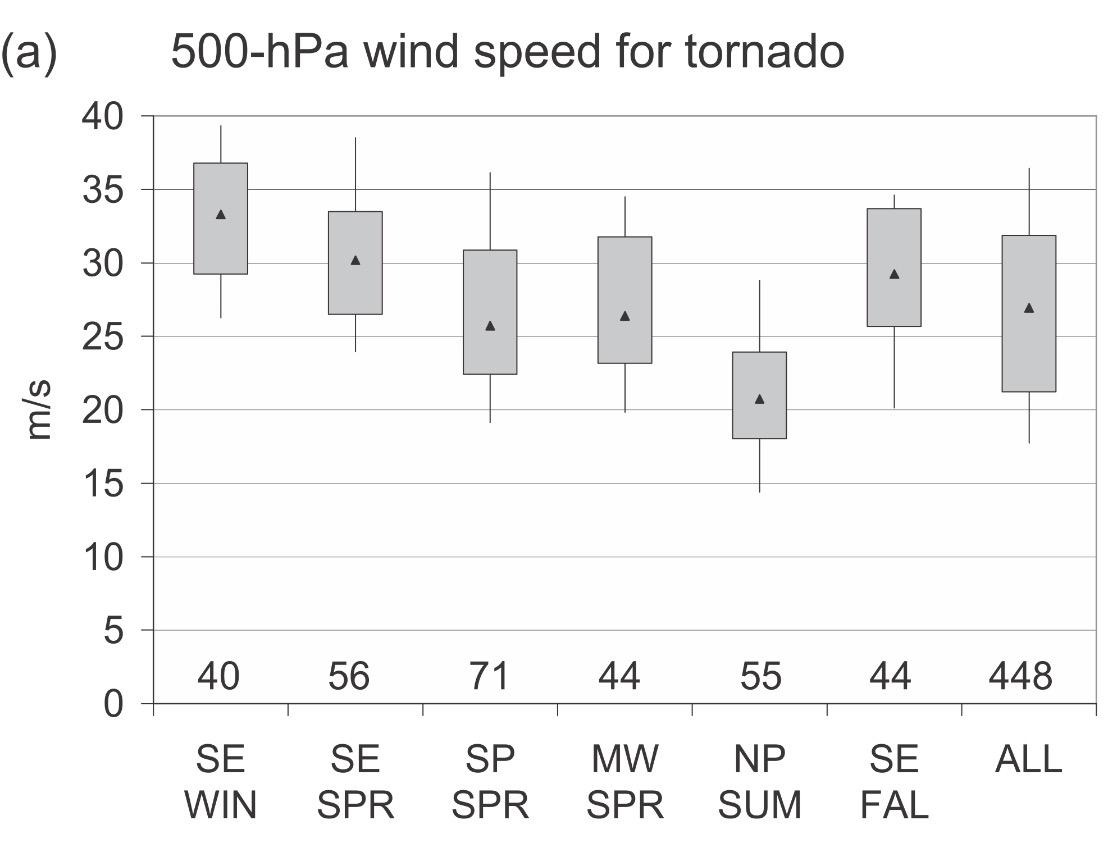
Addressing the 500mb wind threshold, the median value for northern Plains significant tornadoes in the summer is about 40 knots (Grams et. al 2011), with less than 25% of significant tornado cases featuring 500mb winds below 35 knots. With that said, Chapman (5/25/16) was associated with 31 knots of h5 flow (00z TOP) and the northeastern Nebraska tornadoes of 6/17/14 also saw about 31 knots, based on the 00z OAX sounding. Dodge City's 19z sounding from 5/24/16 sampled 36 knot winds at h5. Bowdle was much stronger at 500mb with 52 knots sampled by the 00z ABR sounding. I prefer 30 knots at 500mb as a lower bound for tornado favorability, but would like to see at least 40 knots. Substantial 0-3km SRH (and/or extreme instability) can make up for otherwise marginal 500mb speeds, but I can't immediately come up with any long-track tornadoes that occurred with <30 knot winds at h5.
-
Central/Western Medium-Long Range Discussion
Quincy replied to andyhb's topic in Central/Western States
Agree with the points above. If I had Friday off, I'd venture north, but I concur that this weekend not a setup to make a long haul out for. I'm taking the down time to get work in, as we may have a lengthy active stretch coming up. Saturday may end up being an in between day before the late weekend/early next week pattern looks to feature at least a couple of solid severe potential days. The 00z Euro was very encouraging, but remember that models will adjust a bit in the medium range, so details are TBD. Speaking of models, the CFS has been consistent in showing a sharp turn around in the pattern. While high-end days don't seem likely, it appears that down days next week will be more the exception than the rule. While the CFS has little to no skill over climo beyond day 10 (so don't get too excited about the second half of June being a blockbuster period just yet), in my experience, it's quite good at general patterns inside of 7 days. For positioning, it looks like a bit of a late June/early July-like period with the northern Plains/upper Midwest being the favored areas. You may see some threats shift east into the Great Lakes vicinity, while capping becomes a big concern with southward extent over the Plains given the strength of a ridge over the South. -
Central/Western Medium-Long Range Discussion
Quincy replied to andyhb's topic in Central/Western States
The next week or so looks like a continuation of the pattern. It's fairly unusual to observe such a long period like this given the time of year to see the Plains so quiet. (We will probably end up with a 2-3 week run featuring substantially below average tornado activity during the climatological annual peak of late May/early June) Aside from a few tornadoes in the western part of the state, Oklahoma gets off the hook again without much substantial tornado activity, despite a few "higher-end" threats in the state to finish off May. The longer range guidance seems to be zeroing in on some pattern improvement by late next weekend or early the following week (beginning in the June 11-13 period), but given fairly prominent ridging over the Midwest, the area of focus may end up being from the northern High Plains into the Dakotas. While this is not completely unheard-of for June, it may mean a rare quiet spell for Kansas continues. Despite the above-average tornado activity, places like Kansas and Oklahoma have been relatively quiet. I guess all of the early season tornadoes in the Southeast and some increased activity in Texas account for much of the tornadoes so far this year. It's also been a year largely void of long-track and/or photogenic tornadoes. Going back to the quote above, weather likes to balance out in the long run. Aside from April 27-28, 2014 featured a putrid tornado season until a stretch in mid-June. While I remain cautiously optimistic, any such pattern change remains to be seen. Will it be dampened out? Will trough ejections be displaced too far north? Will the change continue to be pushed back later and later in June? Only time will tell. -
Central/Western Medium-Long Range Discussion
Quincy replied to andyhb's topic in Central/Western States
Confidence in this range is relatively good through day 10 and just wow. There were hints from a few weeks out that this period would improve, but now that's far from the case. This may be one of the worst late May/early June stretches (at least for photogenic and/or longer-lived tornadoes) for tornadoes in a while. Yes, there were a few events and some local accidents, like Wisconsin, but otherwise it's largely been a dud in the Plains. Bigger days have largely been busts or filled with messy storm modes. There have been very few long-lived supercells over terrain west of I-35. Most events (from a chaser/photographer perspective) have been "right place at the right time," otherwise a lot of hair pulling, highly challenging events The last couple of CFS runs are as quiet for a 7-10 stretch as they have been since early May. The support across the board is fairly consistent with general troughing in the East and few, if any notable shortwaves impinging on the Plains. As we move into June, you'd expect that eastern Colorado and vicinity will have a few events (even with marginal/questionable environments) and northwest flow can eventually be more meaningful in terms of severe across the Midwest/Great Lakes as the calendar shifts deeper through June, otherwise, it looks like a snoozefest. There's always the potential for a mesoscale accident, but... -
Central/Western Medium-Long Range Discussion
Quincy replied to andyhb's topic in Central/Western States
The overall CONUS pattern looks favorable for really the balance of May. That may not be saying a lot (as the period is active in most years), but general troughing in the West should allow fairly steady shortwave ejections into the Plains over the final 10-15 days of May. It's really a solid looking pattern for at least near average severe activity as we near the climatological peak of the season. The potential exists for a couple of bigger days, as one would expect with such a pattern, if things line up just right There has been volatility in the ensembles regarding the final days of May into early June, where the Euro weeklies suggest there may be a bit of a lull. I'm not too concerned about anything beyond week 2, as things could change substantially. Nonetheless, a relatively active pattern not only next week, but probably the week following should be on tap.
-
Central/Western Medium-Long Range Discussion
Quincy replied to andyhb's topic in Central/Western States
A pattern flip is certainly plausible. I wouldn't be surprised if late May is rather active. With that said, seasonable activity in comparison to the current state of affairs would seem like a big difference. It's hard to screw up late May unless you get a bizarro cutoff low over the Ohio Valley, or massive ridge over the Rockies.