Quincy
-
Posts
6,220 -
Joined
-
Last visited
Content Type
Profiles
Blogs
Forums
American Weather
Media Demo
Store
Gallery
Everything posted by Quincy
-

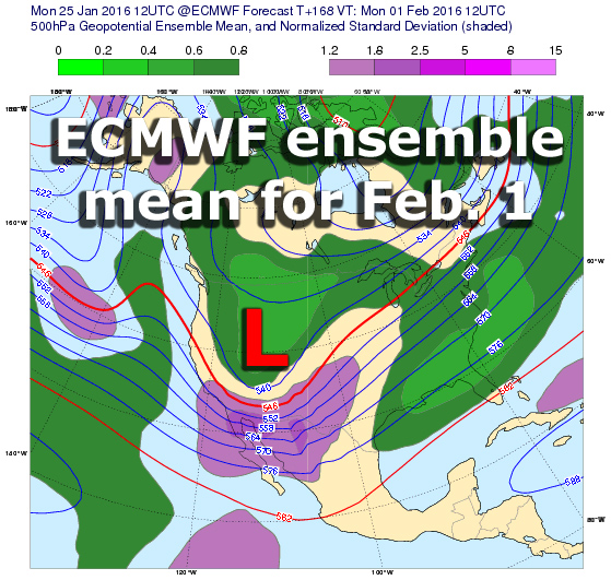
Central/Western Medium-Long Range Discussion
Quincy replied to andyhb's topic in Central/Western States
Something is going to happen, but will it be significant and what area will be targeted? Climo seems to favor Gulf Coast/Dixie, but even with poor instability, this sort of setup would probably still produce at least some severe. It's been a very consistent signal, overall, on the models for quite some time:
-
Here is a snowfall map using reports from various sources. Many of the reports came from this forum and the National Weather Service. Only social media reports that passed through quality control were considered. All reports gathered were carefully considered and compared before being included. Snow reached southern Connecticut during the predawn hours on January 23rd. The snow gradually moved inland, dropping the most persistent bands of moderate to heavy snow on an axis from Fairfield County, northeastward into New Haven County and parts of eastern Connecticut. As low pressure slowly moved east to the south of Long Island, precipitation never reached the far northwest corner of the state. During the peak of the storm, winds consistently gusted to between 30 and 40 mph along the shoreline. No Connecticut stations officially reached blizzard criteria, but near-blizzard conditions affected southwestern Connecticut at times. Breaks in the precipitation shield across southeastern Connecticut resulted in locally lower amounts of snow, particularly across New London County. Snow quickly came to an end in all areas early on January 24th, ending from west to east across the state. The Blizzard of 2016 affected a large portion of the United States from the Arklatex region, eastward to the East Coast. The most intense snowfall fell from the Mid-Atlantic states into the New York City metropolitan area. Snowfall totals of 2 to 3 feet were common here, with a few locally higher amounts. All-time single event snowfall records were set at Allentown, Baltimore, Harrisburg and New York City’s JFK Airport. A record daily snow depth was also set at Washington Dulles International Airport. Both Harrisburg and JFK Airport reported 14 straight hours of snowfall rates of 1 to 3 inches per hour during the height of the storm. JFK Airport observed 30.2 inches of snow in one calendar day on January 23rd.
-
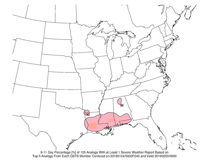
Central/Western Medium-Long Range Discussion
Quincy replied to andyhb's topic in Central/Western States
Two approaches with analogs... The GEFS long-range suite for 00/03 shows some severe risk across Dixie. When using the CPC d6-10 analogs and overlaying the events within 48 hours of the target, there are a few clusters over the Gulf Coast states:
-
Central/Western Medium-Long Range Discussion
Quincy replied to andyhb's topic in Central/Western States
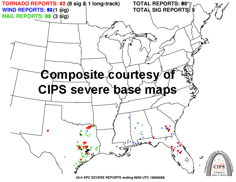
Signal of a threat to start February has been fairly consistent. Certainly going to need to keep an eye on that. -
For the fourth year in a row, overall severe thunderstorm activity, including tornadoes, finished below average across the Lower 48. This graphic shows the severe thunderstorm watch departure from the 13-year average. The vast majority of the U.S. saw at or below average numbers of severe thunderstorm watches. The greatest departures from average were across the central Plains into parts of the Midwest. The only state with more severe thunderstorm watches than average was Texas, with a higher instance of watches over parts of central to southern Texas. What was the cause for this, aside from the seemingly long-term lack of severe thunderstorm activity? The 2015 severe weather season actually got off to a relatively fast start from late March into early April, remaining active into much of May. Attention shifts toward June, which is usually the the peak of the season. June 2015 featured substantial ridging across the western U.S. While not the sole factor, that ridging was a big player in the relative lack of severe thunderstorm activity into June. The severe season climatologically focuses in to parts of the central and northern Plains in June, but the 500mb height pattern in June 2015 was not the most favorable for severe thunderstorms. Some troughing evident over the Great Lakes favored multiple severe weather events across the Midwest and Ohio Valley. However, even here, the season, overall (not in all cases), was on the quieter side. Above image shows 500mb heights and anomalies for June 2015. The overall tornado activity in 2015 was below average, but some parts of the country did see an increase in activity compared to recent years. Portions of Iowa and northern Illinois saw a very active tornado season. This included an early season outbreak on April 9th and a fall event on November 11th. Texas also saw an active season, particularly in North Texas. The High Plains saw a broad area of increased activity, particularly from the Texas panhandle into eastern Colorado and western Kansas. The other part of this graphic that stands out is the lack of tornado watches across the Deep South. Given recent trends and forecasts, it is conceivable that the severe season over the Gulf Coast states, including Florida, may remain on the active side over the next few weeks. Deeper into the year, it is a bit more unclear if March and April will see an uptick in activity across Dixie Alley. Only time will tell.
-
Central/Western Medium-Long Range Discussion
Quincy replied to andyhb's topic in Central/Western States
After a potential outbreak on the fringes of this subforum tomorrow, Sunday could bring another severe event. At the very least, have to expect some potentially heavy snow across portions of the southern High Plains into central Plains. -
Another vigorous through is forecast to sweep through the south-central states over the next few days, bringing a threat of thunderstorms to the region. Although this threat looks substantially less impressive than the event in mid-November, there still exists the potential for at least a few severe thunderstorms, especially Saturday. The setup for Saturday has had a lot of question marks and red flags from the start, but now that the event is approaching, things are coming into better focus. The upper level pattern is split with a fairly complex setup forecast to develop. It looks like two pieces of energy will factor into the southern Plains severe threat. The first will be a strong daytime low-level jet across eastern Texas with vorticity maxima ejecting north-northeast toward the Ozarks Saturday afternoon. The second area of energy hangs back with a cold front and the more substantial height falls across the southern High Plains. The greatest severe threat, although still somewhat limited, should develop from eastern Texas into perhaps southeastern Oklahoma/far southwestern Arkansas during the afternoon hours on Saturday. Aided by a 40-50 knot low-level jet and modest instability, at least a few supercell thunderstorms could fire. Given the wind profiles, all severe hazards appear possible with perhaps a few tornadoes. The threat here shifts to damaging winds as storms merge and should tend to wind down after dark as daytime heating fades and the strongest forcing moves into the Ozarks and Middle Mississippi Valley. The secondary severe threat looks to be from central to North Texas, into central and western Oklahoma. This could extend into Kansas, but with northward extent, instability will become increasingly limited. There are three issues with this area, with the first being a continued messy look to the wind profile. Model soundings have shown a veer-back profile in the mid-levels, producing some jagged, criss-crossing hodographs. Also, some warmer temperatures in the mid-levels should keep the atmosphere capped in most areas until early in the evening. Finally, the trough has slowed down a bit on the models, which also keeps the best forcing farther west until after dark. The timing is analogous to 11/16/15, but instability is significantly less impressive and shear is not as robust. Although a tornado cannot be ruled out, the threat is fairly low. For this area, thunderstorms will try to develop around or shortly after sunset, but may have trouble organizing given the above-mentioned factors. Still, given cold advection aloft and moderate shear, a few briefly discrete/semi-discrete severe thunderstorms could develop. The most likely scenario is that thunderstorms form into a squall line and feature damaging winds as the main threat overnight. Speaking of mid-November, the Sunday threat has a lot of similarities to 11/17/15. Not only with timing and placement, but with the synoptic setup. Keep in mind that 11/17 had more instability and was an “elevated” 10% tornado threat, but the event struggled, mainly producing sporadic damaging wind gusts, although a few overnight tornadoes were reported in Mississippi. This Sunday, the initial squall line looks to be only marginally organized (unlike the robust 11/17 AM line) and the potential for warm sector supercells out in front, across the Lower Mississippi Valley, is fairly low. Still, a few damaging wind gusts and perhaps a tornado or two appear possible. With the warm sector becoming increasingly narrow (pinched) through the day, the aerial extent of severe threat should fade during the second half of the day, despite impressive wind fields aloft.
-
A collection of photographs, mostly involving thunderstorms and storm development across the central United States this spring and summer.
-
-
From the album: Spring/Summer 2015
An ominous, rotating wall cloud augments the setting sun over Hedley, TX. Sept. 20th, 2015. -

From the album: Spring/Summer 2015
The sun lowers in the horizon beneath a severe, hail-producing thunderstorm near Memphis, TX. Sept. 20th, 2015. -
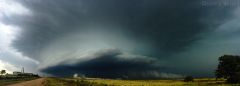
From the album: Spring/Summer 2015
A prominent rotating thunderstorm spins over the Texas countryside just south of McLean, TX. Sept. 20th, 2015. -
From the album: Spring/Summer 2015
A broadly rotating thunderstorm competes with a nearby storm in the vicinity of McLean, TX. Sept. 20th, 2015. -
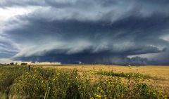
From the album: Spring/Summer 2015
A supercell thunderstorm near peak organization over McLean, TX displays intense inflow with blowing dust in the area. Sept. 20th, 2015. -
From the album: Spring/Summer 2015
A supercell thunderstorm, the first of the afternoon, begins to organize near McLean, TX. Sept. 20th, 2015. -
Central/Western Medium-Long Range Discussion
Quincy replied to andyhb's topic in Central/Western States
The focus has shifted earlier, but perhaps not enough for a big day on Monday. Although the evening looks interesting, the best environment seems to occur overnight across eastern Texas. It's the 06z-12z time-frame that instability is maximized, as the low-level jet really cranks and mid-level lapse rates steepen. Speed this up a bit and it could be really interesting. Tuesday looks messy, although I could see a potent squall line early in the day with embedded tornadoes. -
Central/Western Medium-Long Range Discussion
Quincy replied to andyhb's topic in Central/Western States
12z model suite continues a strong signal for the lower Mississippi Valley and surrounding subforums to the east. Too soon for details, but this easily looks more impressive than what's going on today. -
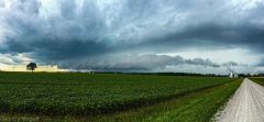
Central/Western Medium-Long Range Discussion
Quincy replied to andyhb's topic in Central/Western States
The GFS/Euro show another dynamic system in the Plains about a week from now. Not quite as impressive as this current system and a bit further south, but worth watching later forecasts and trends. -
Central/Western Medium-Long Range Discussion
Quincy replied to andyhb's topic in Central/Western States
Based on the GFS/Euro (12z), certainly have to agree with this. The Euro actually shows the best instability in the east-central Plains at 12z on Wed, lessening with time with movement into Iowa and Missouri. Likewise, the GFS forecast soundings for eastern Missouri and southeastern Iowa are not as impressive as further west/earlier. -
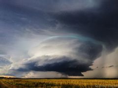
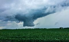
From the album: Spring/Summer 2015
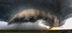
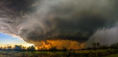
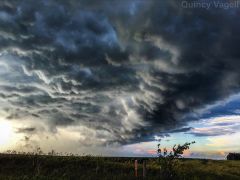
This supercell thunderstorm was in a transition stage. Moments earlier, the storm was displaying a prominent wall cloud, but at this stage, the structure was taking on more of a shelf cloud-like appearance. Near Payne, OH. August 23rd, 2015. -
From the album: Spring/Summer 2015
A short-lived wall cloud drops down close to ground level with a thunderstorm near Grover Hill, OH. August 23rd, 2015. -
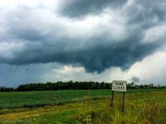
From the album: Spring/Summer 2015
A small, rotating, quasi-wall cloud looms in the distance within this scene from an abandoned road near Grover Hill, OH. August 23rd, 2015. -
From the album: Spring/Summer 2015
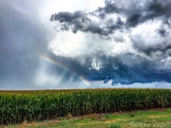
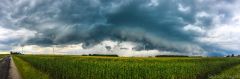
A thunderstorm approaches farmland of corn and wind turbines just south of Payne, OH. August 23rd, 2015. -
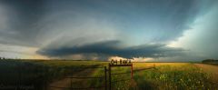
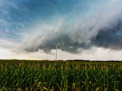
From the album: Spring/Summer 2015
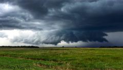
A shelf cloud associated with a strong thunderstorm hangs over a wind farm in rural northwestern Ohio. August 23rd, 2015. -
Central/Western Medium-Long Range Discussion
Quincy replied to andyhb's topic in Central/Western States
I've been casually watching Sunday across the north-central states. A lot can change and there has been some model adjusting, but keeping an eye on a vigorous shortwave forecast to eject across the northern Plains Sunday into early Monday. There may be somewhat of a disconnect between the best forcing, strongest wind fields and the warm sector, but details can be ironed out in the coming days. Based on model indications now, I'd peg the focus on the eastern Dakotas into the Upper Midwest as an area to keep an eye on. Nothing significant and not outbreak-material, but the way this year has gone, at least it's something on the radar. I wonder how this fall will shape up, if it may try to pull a 2013 or keep the trend of generally lackluster severe threats. I'd tend to lean toward the latter. -
From the album: Spring/Summer 2015
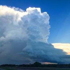
While this supercell thunderstorm had an eerie, ominous appearance, the storm was struggling to organize. As a result, the storm continued to slowly weaken after this August 9th, 2015 photo in far southeastern South Dakota.