Quincy
-
Posts
6,220 -
Joined
-
Last visited
Content Type
Profiles
Blogs
Forums
American Weather
Media Demo
Store
Gallery
Everything posted by Quincy
-

Central/Western Medium-Long Range Discussion
Quincy replied to andyhb's topic in Central/Western States
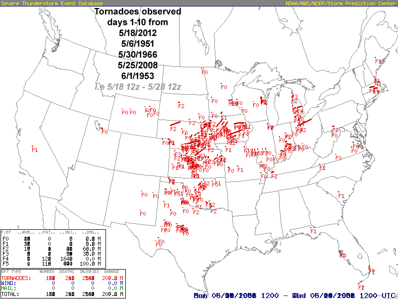
I've taken a bit of a deeper dive into the medium-long range period and based on trends, model guidance and climatology (analogs), it seems probable that the next 2-3 weeks will feature below average tornado activity. Additionally, we may continue to see typically active areas in early/mid-May (North Texas, central/eastern Oklahoma, eastern Kansas; Missouri) remain very quiet. Global guidance is consistent in showing an omega blocking-type pattern through at least the start of next week. This will mean that favorable upper level flow will remain largely split away from the Plains, with a seasonably strong northwest jet from the Midwest/Great Lakes into the Southeast and similarly strong upper level flow across the western United States (transitioning more toward the Desert Southwest by the end of the weekend). Aside from sporadic severe (mainly damaging winds) across the West and East Coast, this looks like about as benign of a pattern as one could draw up for the first 5-10 days of May. Going forward, there is some potential for severe threats to materialize across the southern/central High Plains during the first half of next week, as a cutoff low ejects east from the Four Corners region. Kinematic and thermodynamic fields don't look particularly impressive, especially not for mid-May, although it's likely that tornado activity ticks up a bit next week. My main focus is on the period beyond that. Does this month get out of this seemingly extended early May dearth of tornado activity? Probably not, at least not in any big way. I took a look at two main model projections, the CPC day 8-14 analogs and the new Euro weeklies, which were released within the past few hours. The signal from both camps is more or less the same. The CPC analogs are centered on May 15th and I took the top 5 analogs and ran out tornado counts from days 1-10 in those periods for a comparison. The analog days 1-10 period averaged 55 tornadoes, which is well below the average of 79 for May 15-24. Also, the focus for tornado activity is centered across Kansas/Nebraska/Iowa, which fits the weeklies progs very well. The pattern is projected to feature some troughing over the Great Basin, with a tendency for shortwaves to transverse the central Plains to upper Mississippi Valley. (The period starts with a "death ridge" across the Plains, before the pattern becomes less ugly with time) That would tend to favor severe in the central Plains, which means the May tornado season could effectively "skip over" the Oklahoma/southeastern Kansas/Missouri area. There are at least some instances of tornadoes across the southern High Plains into Oklahoma in these analog periods, but the likelihood of a deep trough bringing substantial tornado threats to the southern Plains through weeks 2 and 3 of May seems fairly low. Overall, the analogs and medium-long range guidance both support below average tornado activity across the Central United States over the next 2-3 weeks, with at least some potential for near/somewhat above average activity in the central Plains/middle Missouri Valley. (Don't count out the southern High Plains early next week) It will be mid/late May, so you can't rule out a bigger event that could throw a wrench in this thinking verifying, but the odds seem lower than 50/50 on such a scenario, which is also climatologically abnormal. It was going to be difficult to bring this year's tornado count back to seasonable levels after such a busy early season, but a below (if not well below) average May could manage to achieve that.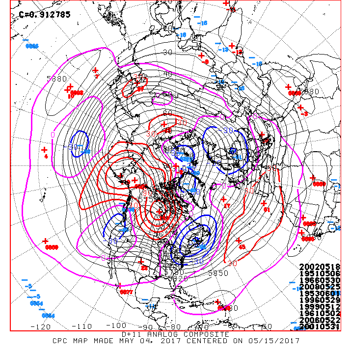
-
Central/Western Medium-Long Range Discussion
Quincy replied to andyhb's topic in Central/Western States
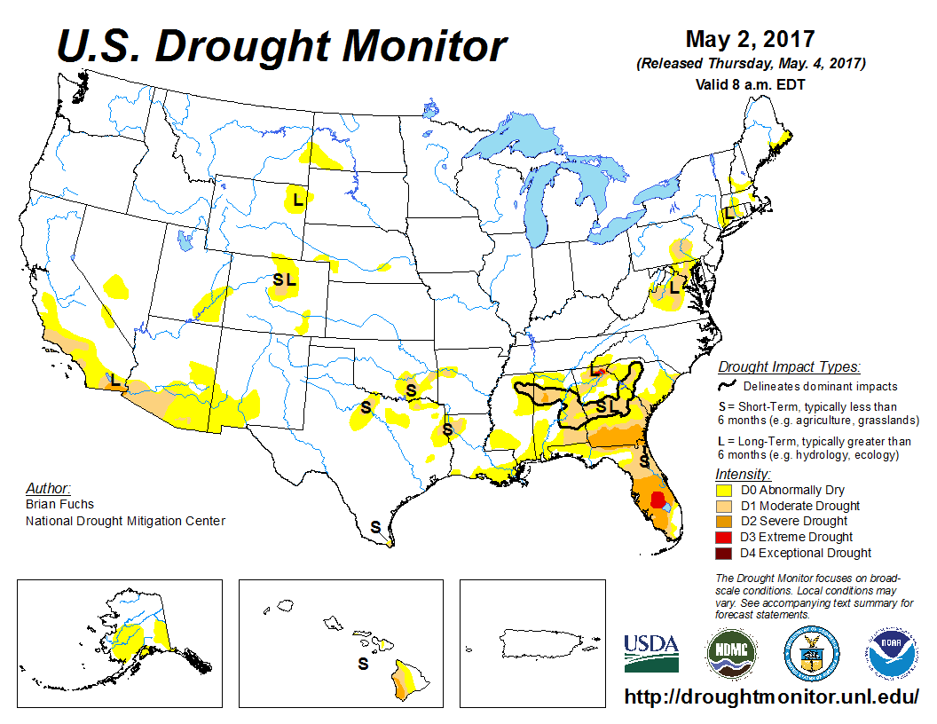
On the bright side, recent heavy precipitation events have wiped out almost all drought areas across the central United States: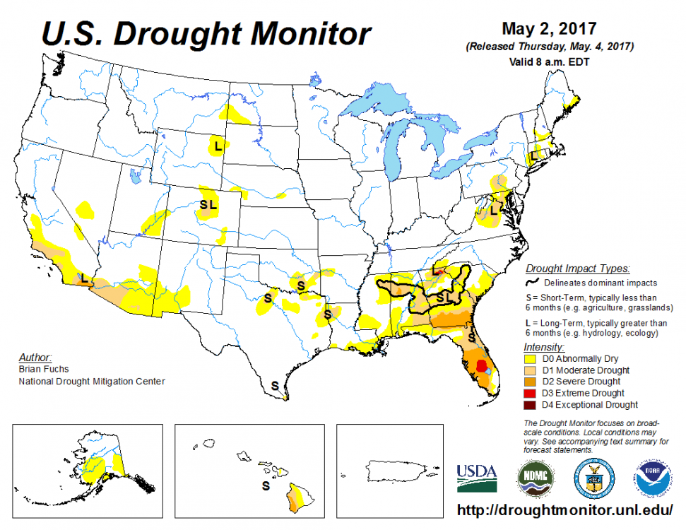
-
Central/Western Medium-Long Range Discussion
Quincy replied to andyhb's topic in Central/Western States
April is hit and miss for Oklahoma. It seems like occasionally there are some big early season events, offset by plenty of years with little action in April. The April average of 11 tornadoes for Oklahoma jumps to 28 in May, but you can see the graph for central Oklahoma spikes sharply into May. On the other hand, we've seen one of the busiest Jan-Apr tornado periods in recent memory across the Gulf Coast states. Overall, we're still well above average year-to-date, but low severe activity through at least the next 5-7 days will probably move us back to near average in terms of tornadoes.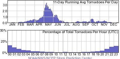
-
Central/Western Medium-Long Range Discussion
Quincy replied to andyhb's topic in Central/Western States
Current trends and analogs suggest severe threats may return by the middle of next week across the southern High Plains, to perhaps as far north as eastern Colorado, as that cutoff low ejects east. Until then, I'll be working extra, unanticipated hours to save up more for prime chase season. Even if things don't line up ideally next week, we're getting into the part of the season when it's harder for such troughs to not produce at least a few tornadoes. -
Central/Western Medium-Long Range Discussion
Quincy replied to andyhb's topic in Central/Western States
What a hostile setup for central U.S. severe potential through at least the first week of May and quite possibly through much of the first two weeks. The relative dearth of severe potential has been consistently modeled for quite some time now. There were some hints about pattern changes into the second week of May a few days ago, but that potential seems to be dialing back as well. The pattern favors two cutoff lows effectively shutting down any significant severe threats in the Plains over the next 7-10 days. The lead low works to scour rich, Gulf moisture, as the 12z ECMWF struggles to bring >50F dew-points north of Oklahoma through 240 hours. There are only a few panels in which low to mid-50s dews squeak into parts of Kansas. That's quite a feat to keep the central Plains that consistently dry through the first 7-days of May, especially given excessive, antecedent rainfall across a broad portion of the central United States. Back west, while modeling showed western U.S. troughing for a while, such a trough may result in a meandering cutoff low over Southern California. Such a low remains too far west for any appreciable large-scale forcing across the Plains. Some analog guidance has hinted at some potential across the southern/central High Plains later in the day 6-10 period, where upslope flow can work to offset otherwise seemingly marginal (at best) low-level moisture. Outside the sub-forum, this pattern could yield some severe potential from the eastern Gulf Coast states into the Carolinas. As we know, forecasts for a week out can significantly change. Look out to day 10 and beyond, and sometimes the model progs end up being way off, as patterns evolve much differently than expected. Nonetheless, barring some sort of mesoscale accident or extreme model error, this upcoming week looks about as dead as it could possibly be across the Plains with respect to severe potential in May. It's been mentioned before and it's actually fairly common to see a bit of a severe lull in early May. The difference here is that the medium-range pattern looks so hostile for severe, that we may see little to no severe thunderstorm activity in the Plains for quite some time. The only day of slight interest this upcoming week looks to be on Tuesday, where there could be some modest severe potential across Oklahoma. Such a setup will revolve around a lot of ingredients coming together, as the synoptic scale pattern does not look particularly favorable.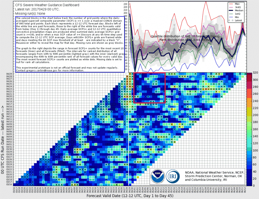
-
Central/Western Medium-Long Range Discussion
Quincy replied to andyhb's topic in Central/Western States
Nothing stands out in the next 10 days. That's not to say you can't get a mesoscale event or two, or perhaps some change in the pattern, otherwise it looks like a relatively quiet mid-April stretch. -
Central/Western Medium-Long Range Discussion
Quincy replied to andyhb's topic in Central/Western States
Those cells look to be east of the instability axis and are moving into a region with considerable CINH. Some cu is spitting off the dryline in western OK, but even there, at least some capping is holding on.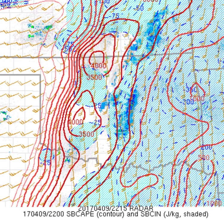
-
Central/Western Medium-Long Range Discussion
Quincy replied to andyhb's topic in Central/Western States
The lack of more turning with height seems to be the biggest red flag. Steep lapse rates are there and both the EC and NAM erode the cap by 00z. EC also favors a discrete storm mode as well. Although moisture is better than some recent events, the EC favors near 60F dews, as opposed to the more bullish NAM. This, along with veered flow/largely unidirectional wind fields aloft points toward a marginal tornado threat at best. Mixed signals here, but a lower end severe (mainly hail) event seems most reasonable, unless things trend in another direction soon. Not unusual at all for early April, but not particularly impressive either. -
Central/Western Medium-Long Range Discussion
Quincy replied to andyhb's topic in Central/Western States
It's still a long way out, but have to wonder if Thursday may feature an early season west-of-I-35 threat from the Texas panhandle into the central Plains. Wind fields strengthen ahead of a trough ejecting east from the Desert Southwest. Even the Euro shows an area of mid to upper 50s dews with convective precip ahead of a dryline. The quality of moisture return appears to be the biggest question at this stage. Friday seems like the best threat day at this point, especially if models slow down a bit more as they already have over the past few days. -
Central/Western Medium-Long Range Discussion
Quincy replied to andyhb's topic in Central/Western States
It's still early in the season. It's not particularly common for events in the Plains or Ohio Valley through about mid-March, aside from outlier outbreaks. Limited moisture is a glaring issue, unless you get a string of anomalously strong surface lows diving north into the Upper Midwest. The early signs have been encouraging at the least. While we may quiet down a bit upon finishing up February, I am looking ahead in a cautiously optimistic manner. About two months into the year, we've seen the most early season tornadoes since 2008. Even if we flatline for the next two weeks, we'll still be above climo, year-to-date. -
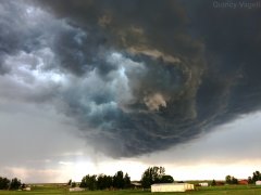
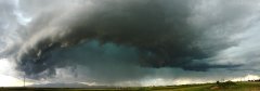
Photos of thunderstorms across the central United States during the summer of 2016.
-
-

From the album: Summer 2016 Thunderstorms
Mammatus clouds become more prominent in the sky, just west of Buffalo, South Dakota. August 9th, 2016. -
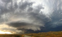
From the album: Summer 2016 Thunderstorms
A tornado-warned thunderstorm seemingly drags a low cloud base just above the ground near Camp Crook, South Dakota. August 9th, 2016. -
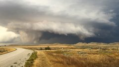
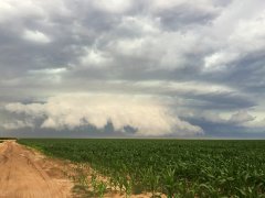
From the album: Summer 2016 Thunderstorms
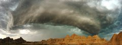
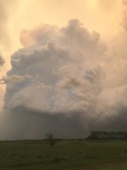
An intense supercell thunderstorm with a history of producing hail larger than softballs in southeastern Montana begins to move into northwestern South Dakota. August 9th, 2016. -
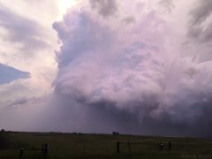
From the album: Summer 2016 Thunderstorms
A tornado-producing thunderstorm takes on a purple tint as the sun begins to set near Warwick, North Dakota. August 3rd, 2016. -
From the album: Summer 2016 Thunderstorms
A thunderstorm just southwest of Warwick, North Dakota produced a tornado on August 3rd, 2016. This photograph captures the early stages of the tornado. -
From the album: Summer 2016 Thunderstorms
A supercell thunderstorm near Buffalo, South Dakota. July 31st 2016. -
From the album: Summer 2016 Thunderstorms
A cluster of thunderstorms developing over Cimarron County in the western panhandle of Oklahoma. July 29th, 2016. -
From the album: Summer 2016 Thunderstorms
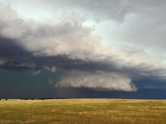
A thunderstorm fills the sky over Glad Valley, South Dakota. July 22nd, 2016. -

From the album: Summer 2016 Thunderstorms
A thunderstorm approaches Isabel, South Dakota from the west. July 22nd, 2016. -
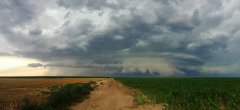
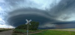
From the album: Summer 2016 Thunderstorms
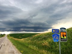
Panoramic view of a tornado-warned thunderstorm displays a low cloud base near Johnson City, Kansas. July 15th, 2016. -
From the album: Summer 2016 Thunderstorms
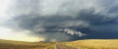
A tornado-warned thunderstorm displays a low cloud base near Johnson City, Kansas. July 15th, 2016. -
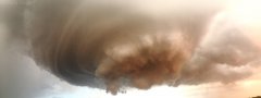
From the album: Summer 2016 Thunderstorms
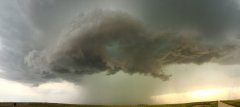
A panoramic view of a mesocyclone directly overhead. This thunderstorm was producing ping pong ball sized hail at the time near Geuda Springs, Kansas. July 13th, 2016. -
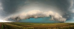
From the album: Summer 2016 Thunderstorms
A panoramic view of a thunderstorm displaying a prominent hail core, as noted by the deep blue inner color. Mound, North Dakota. July 10th, 2016. -
From the album: Summer 2016 Thunderstorms
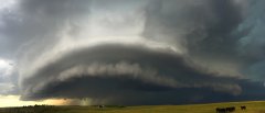
A rotating supercell thunderstorm slowly approaches from the northwest near Carrington, North Dakota. July 9th, 2016.