


OHweather
-
Posts
5,046 -
Joined
-
Last visited
Content Type
Profiles
Blogs
Forums
American Weather
Media Demo
Store
Gallery
Everything posted by OHweather
-
To answer @Frog Town's question, it is both a radar beam height issue and lake enhancement climatologically weakening across NW Ohio issue. The radar beams are highest over the I-75 corridor between Findlay and Toledo (an FAA radar south of Detroit helps over Toledo, but was down for over two weeks in late December), so lower-level snow such as lake effect will be under represented by radar over that area. @Chinooktouched on that well. However, Northwest OH (particularly the Maumee basin) is also an elevation minimum, so a little bit of down sloping also occurs and weakens any lake enhanced snow showers to an extent.
-
Returned home to a solid snowpack this afternoon compared to what it was Wednesday morning. Would guess my house saw 6 or 7" of snow while I was gone based on nearby reports. Wednesday afternoon and evening looked like a particularly snowy period on radar, heard the roads were quite bad.
-
Measured about an hour ago…0.8” of fluffy snow through the day to push my event total to 3.9”. Light snow with the first little clipper has picked back up over the last half hour. We haven’t had too many stretches like this where it just wants to snow in recent years, this is good stuff! Glad the band that flared up this afternoon helped make up for lackluster totals last night to my north.
-
I could see that 12-18" additional panning out near the lakeshore in far NE OH, especially in northern Ashtabula County, but Geauga County won't get that much IMO. The downside of grouping multiple counties together in a warning. It just seems like there will be too much of a break after snow lifts out of there tonight, and I think stuff will progress through too quickly with the cold front tomorrow evening. There's definitely a shot Geauga County verifies a warning at some point (they haven't yet...) but the 12-18" more feels inflated there. We'll see, as I've been wrong before. Nice band ongoing at the moment.
-
Roughly 3" total from everything yesterday through this morning here. I was a little surprised by the last second (ish) Geauga warning yesterday, but thought the totals by this morning in the higher terrain/upslope areas would still be a little better than they are. Would agree with NEOH that strong winds were the main issue, as once winds turned WNW the organized banding did not last long closer to the lake. Driving across Cuyahoga County in the 9-10 PM timeframe, there was actually a fair bit of graupel mixing in (it was dendrites at my house in northern Summit when better returns moved overhead). PBZ managed to pull a 10" total out of Jefferson County OH (!!) from a band of moisture from Lake MI that began upsloping near MFD and then was persistent from there points ESE to a little south of downtown Pittsburgh overnight into this morning, so I guess you had to go reallllly far inland to get the good snow with this much wind. It does look like parts of Portage/Trumbull/southern Ashtabula into Crawford PA got 3-5" type amounts overnight into this morning closer to NE OH. It seems like the remaining LES with this first portion of the event is going to be mainly light...it is still relatively fluffy so if there's any increase in organization as the winds shift more westerly and fetch increases through this afternoon/evening it's possible someone gets another 2 or 3", but I don't think it'll be that exciting overall. A pretty prolonged WSW flow locks in tonight through most of Wednesday afternoon ahead of the next clipper. The LES parameters aren't extreme at all in this timeframe, but by the time you get to ERI the forecast soundings are half decent with instability and lift getting into the bottom half of the DGZ, with deep moisture above that. This should be a window where the lakeshore areas between Lake County OH and Erie County PA can actually get some decent snow, though I am a little skeptical about our LES Warning for Lake County to be honest...just am concerned the snow won't be that heavy that far west based off of forecast soundings being pretty meh around Cleveland until later Wednesday afternoon. However, that is the type of flow that should theoretically produce near the lakeshore. Winds come around NW to even NNW quickly Wednesday evening as a cold front moves through. There should be a period of mainly light synoptic snow just ahead of the front and a burst of snow along the front itself, which will be enhanced by the lake. The lake enhanced burst of snow along the front should be intense, but the fetch goes short quickly and forecast soundings quickly suggest much drier air moving in Wednesday night...so while I'm sure there will be some disorganized LES Wednesday night into early Thursday, it may not add much more. So I think everyone gets more snow Wednesday afternoon and evening with the clipper/front, but the LES may not add much (outside of the lakeshore where they have a longer opportunity tonight through Wednesday afternoon). Still wintry, but it wouldn't surprise me if the currently advertised totals are a little hard to hit. I'll be out of town from tomorrow morning until some point later Friday, so I will miss out on whatever makes it down here tomorrow evening.
-
Yeah even if you get something closer to 5-6”, it’ll blow around a ton. Should be a fun next 12 hours or so around here! At least for those who like winter and snow/blowing snow…
-
Things should kick off quickly by mid-afternoon as a band of lake-enhanced snow squalls along a sharp trough pushes off the lake. Thereafter, inversion heights and moisture depth do become marginal pretty quickly but the airmass will support good snow growth even in shallow LES bands, and upstream radars still look solid...so, there's optimism for a window of continued WNW flow LES into a good portion of tonight behind the squalls along the trough axis this afternoon.
-
The period of snow showers/squalls along the trough axis that will swing southeast across lower MI/far northeast IN and northern OH during the day Monday will be accompanied by some impressive conditions...the temperatures will be cold enough for the relatively shallow snow showers to produce good dendrites, and winds will be gusting 45-55 MPH. The low levels will be unstable enough for the snow showers to have some convective component, so they'll be squally. The snow/blowing snow combination will be impressive for a 1-3 hour period. I'm guessing some snow squall warnings are a possibility.
-
All of a sudden, this looks like a pretty snowy few days starting on Monday in NE Ohio
-
Interesting stats! Obviously it has felt like the coldest start to winter in a number of years, but it's impressive that this prolonged snow cover is so rare for this early in the season. 2010-11 was quite a winter...
-
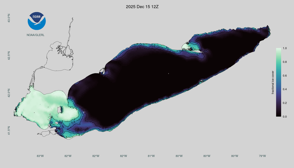
5.8" total here from the clipper + LES. The cold has done a number on western Lake Erie!
-
A little over 4" here so far (a bit over 2.5" from the clipper, about 1.5" from LES). Should see stuff fill in towards midday, good chunk of dry air moving overhead this morning.
-
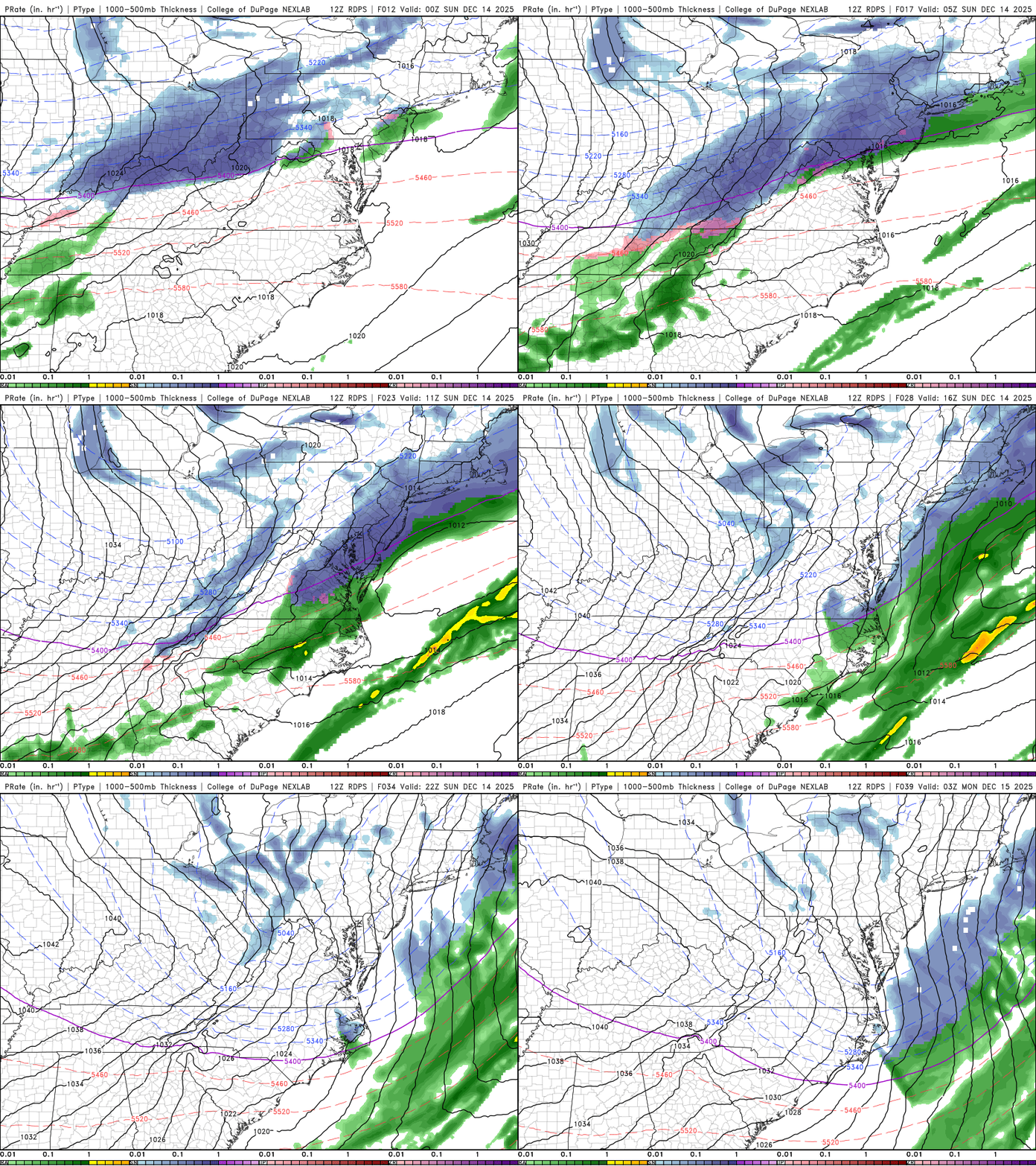
The 12z RGEM would be pretty interesting for the western lakeshore and secondary snowbelt at times overnight tonight through Sunday! It also looks plenty snowy for the inland core snowbelt.
-
December 11th-14th Double Banger Clippers
OHweather replied to Jackstraw's topic in Lakes/Ohio Valley
Pretty cool how there's literally no surface reflection with this clipper. All the snow is driven by mid-upper level jet dynamics and frontogenesis.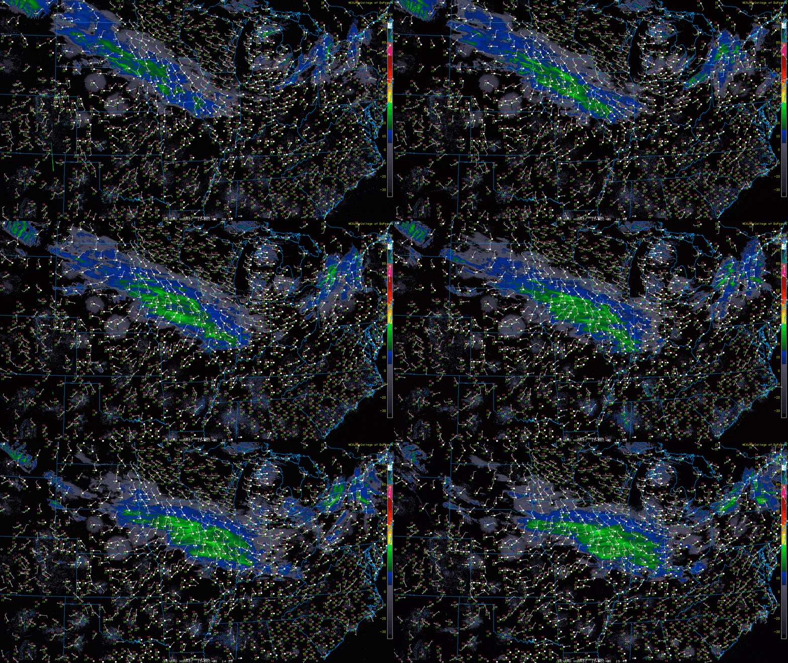
-
For verification purposes later, here was the snow map that fell out of my forecast this afternoon. If I were to say there are two areas I'm most concerned about, it's potential for a locally higher amount in the secondary snowbelt or western Cleveland metro area (i.e. western Cuyahoga or Lorain, Medina, Summit, Portage or Trumbull) if banding settles into those areas Saturday night or Sunday...and also potential for the eastern lakeshore to again come in lower than forecast if banding doesn't settle over that area late Saturday afternoon/evening.
.thumb.jpg.9c56cea5ea53a29e2cbaf7a933d571a5.jpg)
-
I decided to give the trails at West Woods not too far from NEOH and DTA a visit yesterday afternoon. The amount of snow on the ground in that area was shocking compared to what I had in northern Summit (was down to about an inch of dense snowpack yesterday afternoon), and the gradient is really noticeable between Macedonia and even Twinsburg and Solon. Also, hiking around here is not fun right now lol, need some more snow to cover up the old/packed down ice and mud. Had a 2.1" measurement (which doubles as a storm total) around 8 AM this morning, another quick burst a little after 10 AM dropped a fluffy half inch or so. We'll see if I can get any more bonus snow from lake squalls through this evening down here. Looks like some lake enhanced snow Saturday into Saturday evening with a W or WNW flow as the clipper goes by, which could favor the northern half of the snowbelt. Winds go more NW into Sunday as the coldest air moves overhead which should favor the inland snowbelt yet again. The moisture is definitely best with the first phase of the event Saturday afternoon and evening. The instability increases into Sunday as brutally cold air aloft moves in (850mb temps of -20C or so), but I have some concerns about a shorter fetch by then, drier air at times, and lower snow ratios due to it becoming colder than ideal. I don't doubt that LES will continue through Sunday and into Sunday night across inland portions of the snowbelt, but you may need to get under an upstream connection to get better accumulations in that window.
-
Decent burst of snow this evening. Already a good inch here and still snowing. Roads are not good.
-
Was a good 2-3 degrees warmer than expected this morning. Wasn’t expecting a ton here, but was hoping for at least a little slushy accumulation which definitely did not occur.
-
Recent guidance still holding onto snow for several hours into the morning across much of NE Ohio. It will not be that cold and the lower elevations will probably have to deal with lower ratios/more melting and a bit more rain mixing in, but I think those of you over 1000 or so feet could easily get a quick few inches of snow. Tried to finagle a bit more snow in the forecast this afternoon, but couldn’t really get enough to expand the advisory into OH without throwing the forecast completely out of collaboration. That said, it would not surprise me if someone in Geauga ends up getting 4” or so through Wednesday morning, but it’ll likely be quite terrain dependent. Am becoming a little more intrigued by the LES potential in a WNW flow the second half of this weekend…will be curious how it looks as details become a little clearer in the coming days.
-
Definitely an active weather pattern with some dynamic systems moving through...lots of temperature swings and wind with frequent snow chances. I don't know if this pattern offers a great chance for a lot of snow at once, more nickels and dimes than anything else...perhaps lake effect Friday into the weekend can be somewhat heavier somewhere.
-
3.7" storm total for me, was snowing quite nicely this morning when I woke up with some bursts of lake effect at work during the afternoon. Definitely one of the better starts to the season in recent memory!
-
I don’t expect it to trend down. It’s not all WAA snow with a bunch of dry air in front of it like Saturday night was.
-
Snowy pattern! 6.8" was my LES total, though I never had more than 5" on the ground (the last 2" or so was very spread out) and it's been melting/compacting. Had 1.5" last night, with 1.3" falling with the leading band around 8:30 PM. Not much snow, but it dumped with that band and roads were trash for a couple of hours. A little LES for the snowbelt tonight (not expecting much for MBY), and then another light-moderate synoptic snow Monday night into early Tuesday. I don't expect that one to steadily trend down as we get closer like with what happened to last night's snow in most of OH.
-
Pretty impressed I got this much snow down here...was at a storm total of 5.2" when I measured earlier this morning. Have gotten at least another inch from squalls over the last hour! The HRRR is usually pretty bad with its placement of snow bands but I would say it performed best with this event. It was a few miles too far south (at one point it had me getting 18"), but did a really good job with showing the general area/evolution/organization of the banding that played out compared to the other models.
-
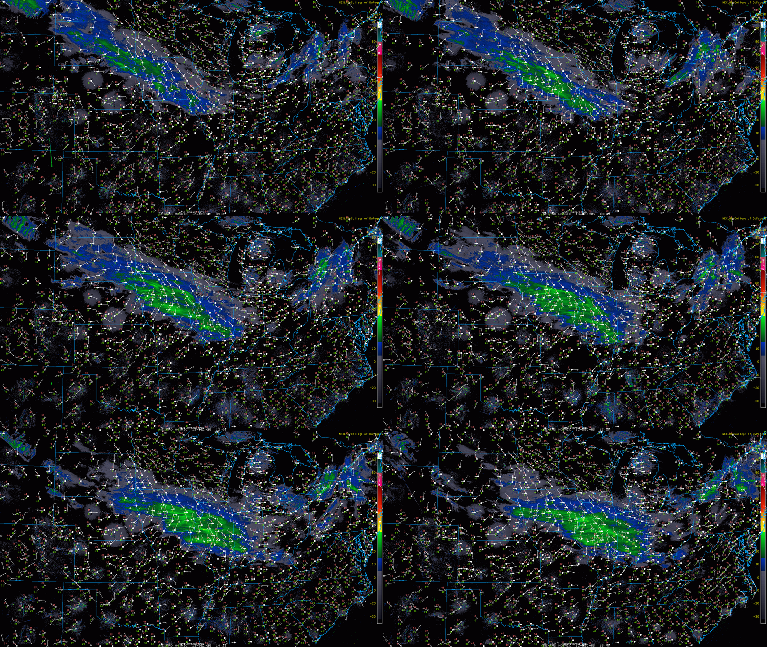
A little surprised at how quickly the band sagged south today. It was not slower than modeled, and I may actually get several inches tonight. Seems like the jackpot zone will be SE Cuyahoga into southern Geauga. Bit of a bust up the northeastern shoreline (not that they were ever going to do great, but thought they’d get a little more earlier today)



.jpg.56bedb7f96350ac18cc12654011e7b49.jpg)