WxUSAF
-
Posts
28,779 -
Joined
-
Last visited
Content Type
Profiles
Blogs
Forums
American Weather
Media Demo
Store
Gallery
Everything posted by WxUSAF
-
I think because there’s a weak precipitation shadow just east of the mountains.
-
RGEM looks like the NAM with (presumably) a 800mb warm layer poking up to around a Laurel-Rockville line early tomorrow morning. Kind of amazing how crappy our air masses have been this winter.
-
Interesting, thanks. But given that’s downwind of us, would need to see if that impacts these short range forecasts over North America.
-
Moreso than other guidance?
-
I mean, I’ll take a euro/NAM blend right now quite happily for MBY. Is the WRF the one you said you liked on Sunday?
-
Euro has definitely NOT been a locked in rock inside 72hrs like it used to be. I’ve seen people on Twitter speculate it’s due to the reduction of aircraft data feeding into it due to covid. But i figure that would impact all the models, so I’m not sure.
-
It makes sense that if the first wave is stronger, it drags the boundary farther south where wave 2 rides along it. And that creates a screw zone where they don’t overlap. On another note, 3k NAM soundings look much improved for central MD vs yesterday when it was looking like a weaker wave 1. After the first hour or two of snow, there’s nice dendrite production for the whole event except right as the mix line pokes a bit north near 8z.
-
Euro total cave to the GFS lol. That said, I like the model consensus for wave 1 for MBY way more than yesterday. Surprised wave 2 has crapped out, but given how fast wave 1 rejuvenated, maybe it’s not dead yet.
-
Huh, some graupel here as well. Over performer!
-
Ha, euro has a bit of that CVA precipitation hole. Caving to the GFS? Euro is lighter than all other guidance with wave 1. Pretty dramatically so. Maybe it’s right, but it’s by itself right now.
-
Can’t post it because I’m on my phone, but 3k NAM soundings look much better in central MD vs 12z, particularly for Thursday morning. Saturated DGZ with good upward motion. If the NAM is right for central MD, would imply wave 1 ends as nice fluff.
-
Has anyone seen a NWS disco mentioning their model preference? Because this clearly ain’t the euro idea
-
Euro is kind of on an island with a dry wave 1. GFS is definitely on an island with a paltry wave 2.
-
Yeah, I didn't buy the 12" stuff. But with a long duration event, a widespread 4-8" seems doable. Probably this works better in a Nino than a Nina. Whether it's the Nina or something else, we've definitely struggled to "close" these snow events we've had. We've lost ground in the last 48-72 hours every time this year.
-
I wouldn't discount the euro, but it's the driest/weakest with these waves relative to the other guidance. And it hasn't exactly nailed our previous storms, whereas a blended forecast from the guidance has done pretty well.
-
Euro's pretty darn dry for both waves. Everyone north of EZF lost 0.2-0.4" of QPF from 0z. eta...it's not so much that it's "south", its just weaker with both waves and has a little more arctic air push, particularly for wave 2. Wave 1 is just weak sauce. Quite a change even from 0z.
-
And I dorked up those percentages. I was typing % of seasonal total normal to date. Probably 75-80% of normal by this date.
-
11"...but still, not that bad. Probably 75-80% of normal to date. Hopefully 17" by Saturday...
-
You're right. GFS sounding for wave 1 probably supports 10-12:1. NAM sounding probably 8-10:1. Both of these for central MD...
-
GGEM and RGEM both are pretty uniform forum-wide winners.
-

Feb Long Range Discussion (Day 3 and beyond) - MERGED
WxUSAF replied to WinterWxLuvr's topic in Mid Atlantic
#consistency
-
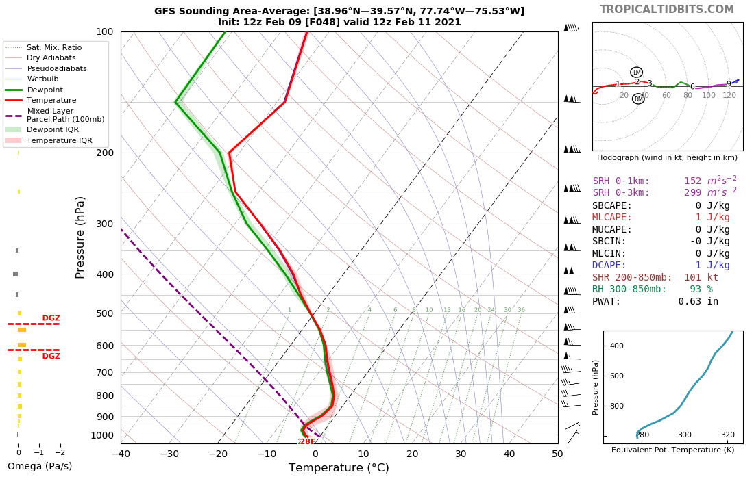
NAM soundings for wave 1 are kinda meh as Pete Mullinax posted on twitter and was quoted here. GFS, on the other hand, looks quite nice for early Thursday morning for most of MD. Good lift in the DGZ and fully saturated. https://www.tropicaltidbits.com/analysis/models/sounding/?model=gfs&runtime=2021020912&fh=48&domain=-77.74,-75.53,38.96,39.57&stationID=&tc=&mode=regular

-
GFS is a little more south on wave 2, but just generally weaker. So mixier for VA.
-
I had to do a double take at those surface temps on the NAM. Euro and GFS (!!) are both a few degrees colder. Can't recall seeing a time recently when GFS had colder surface temps in the Balt-Wash corridor than the NAM.