WxUSAF
-
Posts
28,769 -
Joined
-
Last visited
Content Type
Profiles
Blogs
Forums
American Weather
Media Demo
Store
Gallery
Everything posted by WxUSAF
-
That memory many of you have for forecast failures astounds me. I remember bust events, but I have almost no memory of something that looked good on progs at some point and was clearly a miss by day X.
-
Didn’t Confucius say it was always over until it starts?
-
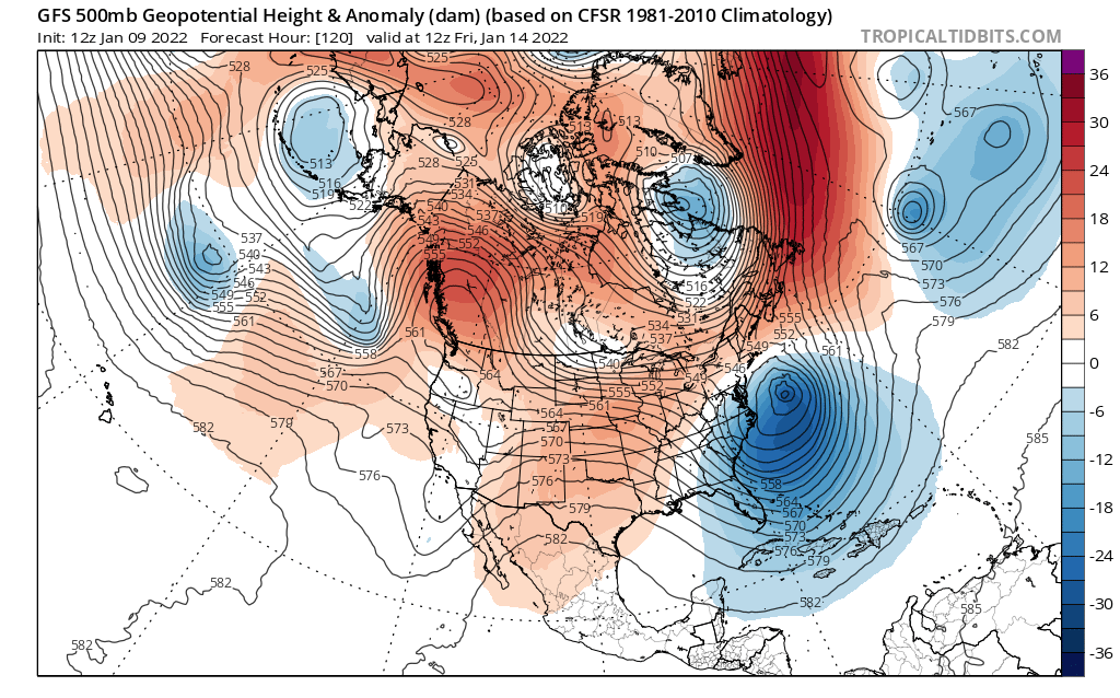
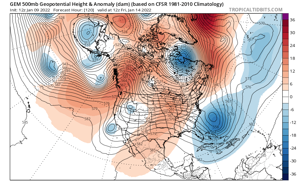
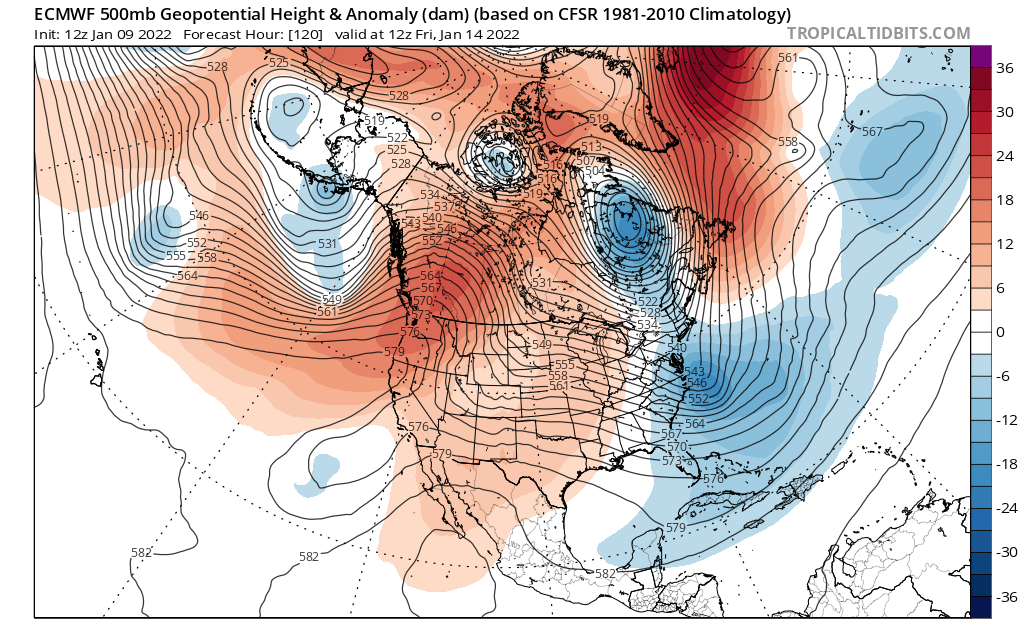
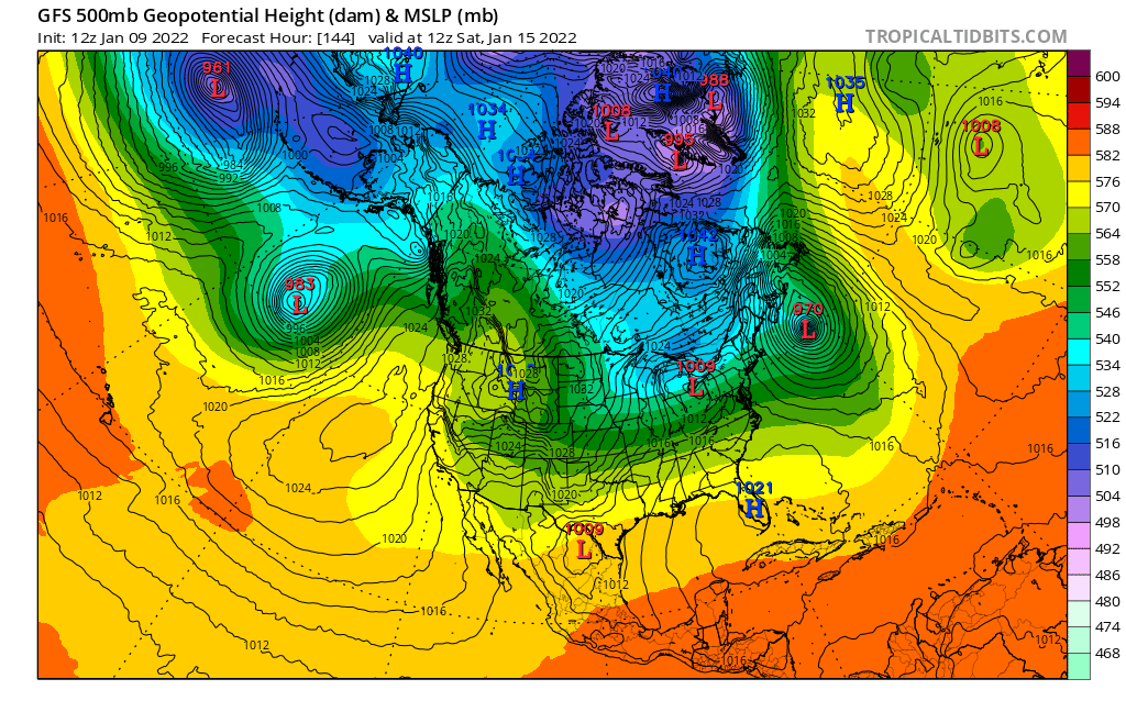
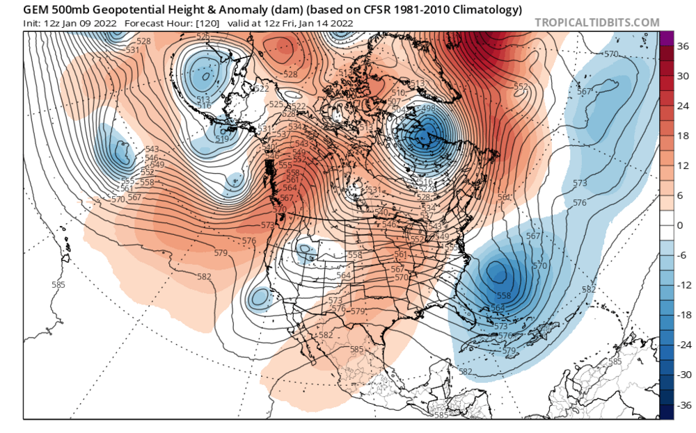
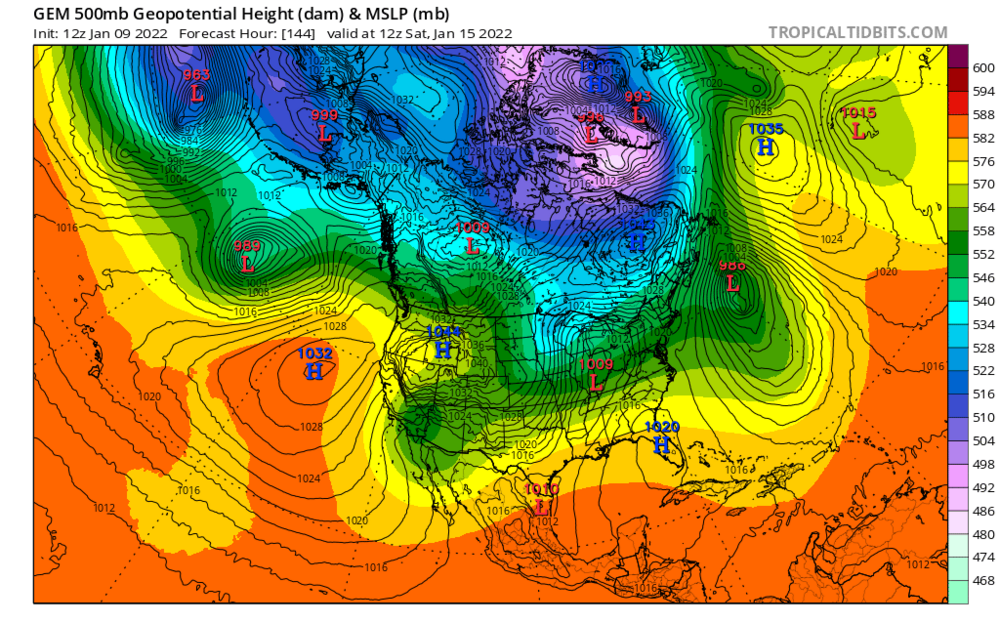
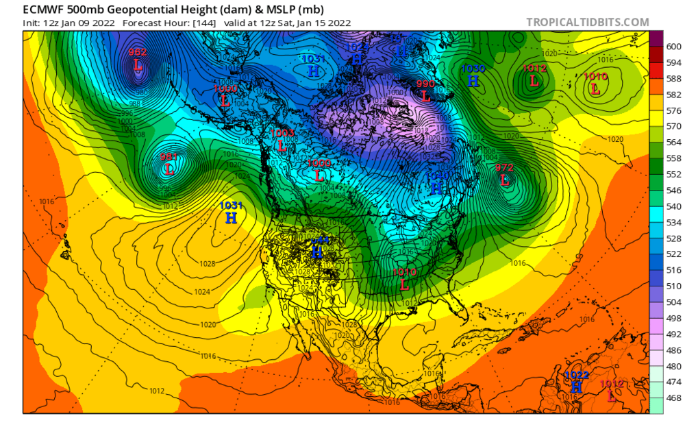
Ok, wanted to make a post showing the impact of the ocean storm on ~Friday to the environment afterward and hence the possibility of a Sunday/MLK day storm. Helpfully, the 3 big globals provided a very nice contrast in this with their 12z runs. Obviously there are other differences that impact the result as well, but I think the ocean storm is a pretty big player to help define the storm track and whether it gives room to the next shortwave/s to amplify. First is the 12z GFS. It produced a very strong ocean storm that was close to shore. For reference across all 3 models, the shortwave that could produce a late weekend storm is near the US/Canadian border over ND/MN in the northern stream. There's also southern stream energy over the intermountain West and southern CA. Next is the GGEM. It's ocean storm is weaker and farther SE over the ocean. It's nearly a cutoff low and just meanders out to sea. Lastly is the Euro. It produces a storm, but it's moving offshore and is "just right" in terms of storm strength. Strong enough to suppress the flow, but not too strong to swamp everything else. Helpfully, also note how the northern stream and southern stream energy already is somewhat "phased" here (all the shortwaves are in line from Los Angeles all the way up to Manitoba). So what happens after? Watch the dark green color, which in this case is the 552 dm height contour, and the light blue (534 dm height). GFS: Look how close the ocean storm is to the surface reflection of our shortwave of interest (the L near Cleveland). Light blue height level right through the Great Lakes. The ocean storm hangs around and is very strong. It suppresses the flow and gives our shortwave no room to amplify. So we end up with a weak frontal passage. GGEM: The storms have more spacing, the ocean low is weaker, and there's TOO MUCH room for our shortwave/storm to amplify. Dark green height contour is well up into OH/PA/NYC. Result? Cutter. Euro: Now it's JUST RIGHT. The ocean storm is nearly as strong as on the GFS, but it's farther OTS. So it's suppressing the flow just enough (dark green contour is through VA), but not TOO MUCH. Hence, our storm tracks farther south and it's bombs away. And yes, the Euro is also good because it phases the northern and southern stream energy. But the storm track is important. Phase the energy on the Euro, but have an ocean storm like on the GGEM and the thing cuts to Hudson Bay and we get warm rain. I think the GFS solution of a strong ocean storm that's close to shore is probably the last likely? 18z GFS was a small step toward a more Euro like outcome. GGEM and Euro like outcomes for the ocean storm are more likely IMO, but that doesn't mean we get a big snowy coastal because that's also contingent on how and if the energy out west phases.


-

Mid-Atlantic winter 2021-22 snowfall contest
WxUSAF replied to AnEndlessMaze's topic in Mid Atlantic
Hmmm…typo then? Weird discrepancy. -
Fitting end to the ravens season with another f-cking exhausting game to watch
-
Mid-Atlantic winter 2021-22 snowfall contest
WxUSAF replied to AnEndlessMaze's topic in Mid Atlantic
Well what am I looking at differently then?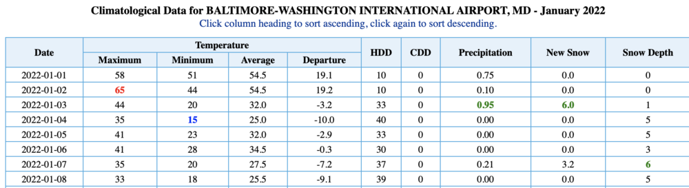
-
I'll try to make a more thorough post later, but as best as I can see, we want that ocean storm to stay offshore and try and act somewhat like a 50/50 storm to suppress the flow and force the storm for next weekend under us. Too strong and west and it will crush that subsequent storm. Too weak and OTS and that storm may cut.
-
-
I wonder if the 89 bust is the one I remember vividly from childhood. Remember being convinced of a snowday for the next day and woke up to clear blue sky. I was so so mad and dejected that day.
-
Just had a shower pass through with temp of 30
-
-
There’s maybe an outside chance at something light with the warm front around Wednesday/Thursday.
-
The threat window opens +/- Friday IMO. And gets better most likely as we move into the following week. But there’s a ton of shortwaves flying around and the track of any storm is contingent on the conditions prepared by the previous wave. I think it’s possible by Tuesday that we might know if we’re in the game for something in the Friday-Sunday period. Anything after that will take longer. Don’t get too beholden too any individual Op scenario until a storm is within 72-96 hours at most.
-
First subfreezing high.
-
It’s sunny today. Bust.
-
“Now witness one of nature’s great spectacles. Middle aged men take their first teetering steps into a world transformed by ice and snow.”
- 56 replies
-
- 13
-

-

-
Places that can retain some snowpack through tomorrow will see it turn into a glacier with the absorbed moisture from the rain and then very cold temps.
-
Not yet… Hit 16F IMBY before midnight, then temps rose for several hours. Now back down to 17F.
-
Down to 19 so far in Columbia
-
Monday’s snow stuck to my solar panels more than any snowfall in the last 5 winters since I got them. 0 power since Sunday.
-
Mid-Atlantic winter 2021-22 snowfall contest
WxUSAF replied to AnEndlessMaze's topic in Mid Atlantic
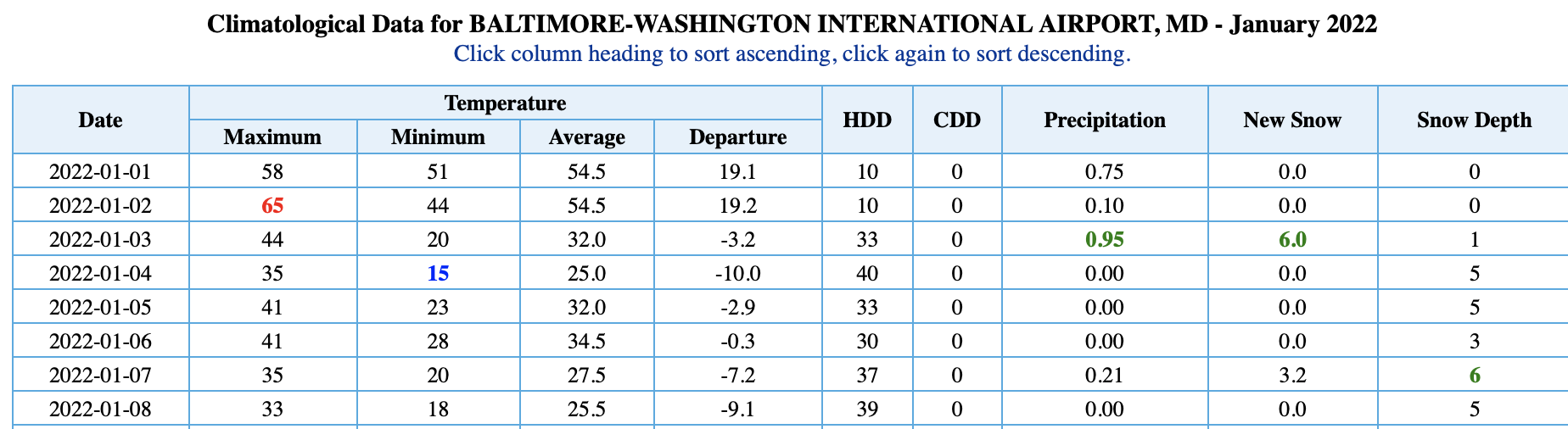
Hmmm…very puzzling. BWI climate report still says 6.0” on the LWX webpage. -
DCA revised up to 2.7”
-
Mid-Atlantic winter 2021-22 snowfall contest
WxUSAF replied to AnEndlessMaze's topic in Mid Atlantic
Check into BWIs total. Think they revised downward on Monday. -
I empathize with the Monday miss but today was a lucky low end warning/high end advisory snow. Northern stream Miller B that we got that? Gravy. Boston cleans up on those, we usually lose.
-
These two events were perfect in a lot of ways. Didn’t really give them any significance until about 48-72 hours, low emotional investment going in, then both overperformed IMBY. Wonderful.