WxUSAF
-
Posts
28,677 -
Joined
-
Last visited
Content Type
Profiles
Blogs
Forums
American Weather
Media Demo
Store
Gallery
Everything posted by WxUSAF
-
Racking up our cold wind seasonal totals already!!
-
I raked yesterday. With this wind, you probably won’t notice by noon today.
-
I liked last winter having a January that felt like January. As long as Xmas week isn’t a flamethrower torch, I can gut through another disappointing December. But I’m cautiously hopeful it has some wintry appeal.
-
Yesterdays GEFS extended
-
I’m keeping expectations in check. Last few days were fairly pathetic. Area wide. Expecting DCA will sneak down to 30 tonight!
-
Weak sauce low temps.
-
Near-record strong -EPO with most of Canada snow covered and we’re going to struggle to get 2 or 3 days with double digit negative departures out of it. Must be all JB’s underwater volcanoes
-
Repainted the snow board with semigloss to help reflect more sunlight. Just need to refill the liquid N2 tank and it will be ready for winter!
-
Gov. Hogan tweeting yesterdays Hrrr
-
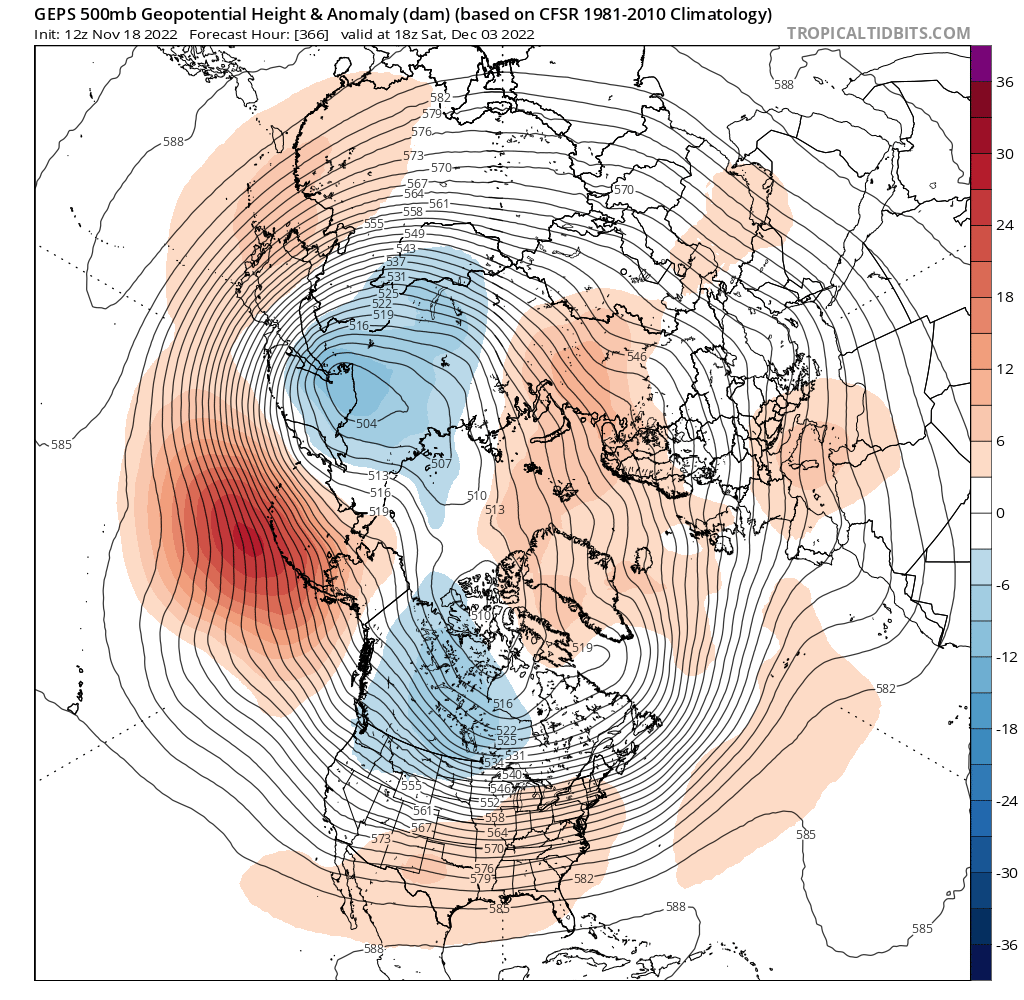
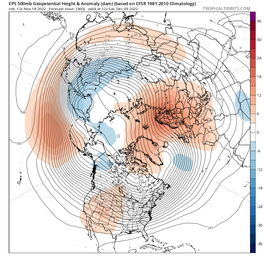
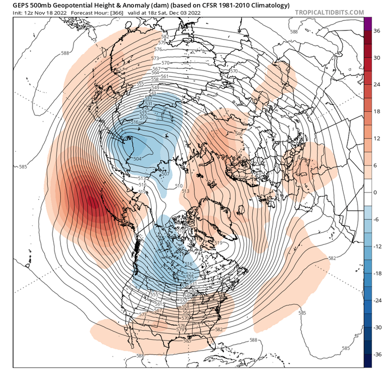
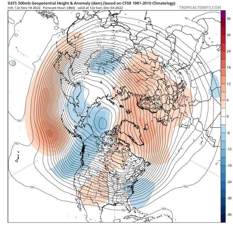
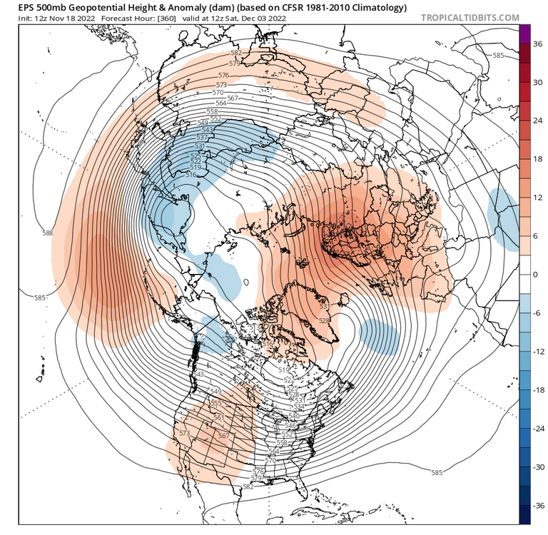
Our slim odds of anything frozen from the Black Friday storm look slimmer now, so let’s check in on the RELAX and RELOAD. Going into the beginning of December, the most robust feature on the ensembles is broad ridging over Europe, Scandinavia, the eastern Arctic Ocean, and extending into Greenland. This -NAO has been pretty stable on the ensembles in the D10-15 period with most of the variation on how far west it extends (e.g. into Baffin Island or Hudson Bay). The other robust feature is the one I mentioned in my last long post: the trop PV over eastern Siberia. All the ensembles have it, but how it plays with the other trop PV closer to the pole seems unclear. What I was hoping for, the Siberian PV to move east to Kamchatka and force the -EPO doesn’t seem to want to happen. The interaction of the 2 PVs keeps the NPac ridge flat. But there are subtle differences between the 3 that change the pattern over the CONUS and maybe what comes after for the RELOAD. Start with the worst: GEPS. GEPS is Nina-tastic. Cold western Canada, -NAO, and SE ridge is very reminiscent of last December and is a classic Nina look. Not what we want to see. GEFS is somewhat intermediary, but also not a look I love. It seems to want to merge the two PVs, maybe toward AK, which is a torchy pattern for us. Don’t be deceived by the blue over us. That’s a little induced trough below the NAO ridge. Extended GEFS show it getting worse after this but then with a somewhat remarkable reversal to a workable pattern around D25-30. Maybe a reflection of tropical forcing? Dunno. EPS is the best look by far even though it’s not dramatically different than the above 2. It weakens the PV over the pole and also the Siberian PV. This weakens the WPO ridge but also the -PNA. The shorter wavelengths put the ridge over the SW CONUS. With the -NAO, that’s a pattern that would be workable with minimal changes, even in early December. This all has been pretty changeable so EPS could be trash and the GEFS looking nice by tomorrow, but this is where we are for now. Think we do relax for the first week of December at least, but TBD if it’s just seasonable (maybe even leaning a little BN) or a borderline torch. Seems like the PV strength and interactions will drive this. Then hopefully the MJO progression leads to another -EPO period while the -NAO is still kicking.
- 735 replies
-
- 33
-

-

-
Got something falling here but just melted snow I think
-
Same. Radar looks good but just virga so far.
-
You’ll be back just in time for RELOAD
-
What a mess this will be. No alcohol and near-slave labor?
-
They hit 31 this morning. Colder than BWI actually.
-
Got down to 29 earlier but have warmed since 2-3am. 33 now.
-
^interesting. +PNA/-NAO/+AO like we have next week.
-
Exactly. Your first scenario could be the magic “storm creates its own cold air” through strong NE flow and heavy precipitation, which helps with crappy climo, but that’s a serious tightrope to walk. So if we go with more of a slider type storm after cold air has arrived (and preferably at night), maybe we can pull the rabbit?
-
It’s a very nice look. More what the GEFS had before 12z went more positively tilted and progressive. Wish it was winter…
-
Ensemble mean was definitely weaker and more suppressed. It’s hard to know what we want at this stage since our climo sucks in November, but I think a weaker solution is probably it.
-
Euro now says “what storm?” For next weekend. This is fun.
-
Euro still has it. Mostly north of 70.
-
Kinda? There hasn’t been a drop of consistency yet so not worth parsing Op runs yet except for the popcorn value. Just seems like an increasing chance of that cold HP arriving in advance of precip with a big storm somewhere in the eastern conus.