WxUSAF
-
Posts
28,765 -
Joined
-
Last visited
Content Type
Profiles
Blogs
Forums
American Weather
Media Demo
Store
Gallery
Everything posted by WxUSAF
-

January Mid/Long Range Disco 3: The great recovery or shut the blinds?
WxUSAF replied to psuhoffman's topic in Mid Atlantic
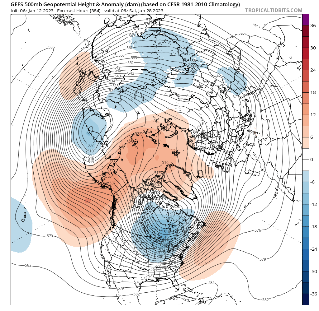
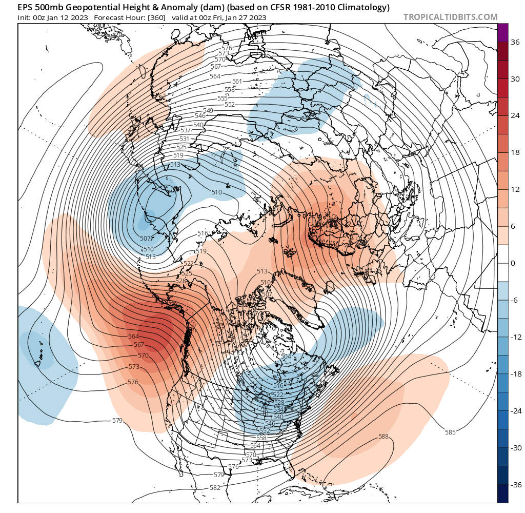
That wave around the 21-22nd seems like it’s the first with any sort of prayer for some frozen precipitation. The huge differences between the GEFS and GEPS (and hopefully still the EPS) today are not that far off…like D7-8 there are major differences in the way they handle the western ridge and CONUS trough. -
January Mid/Long Range Disco 3: The great recovery or shut the blinds?
WxUSAF replied to psuhoffman's topic in Mid Atlantic
I love cats! -
January Mid/Long Range Disco 3: The great recovery or shut the blinds?
WxUSAF replied to psuhoffman's topic in Mid Atlantic
@mitchnick probably remembers -
January Mid/Long Range Disco 3: The great recovery or shut the blinds?
WxUSAF replied to psuhoffman's topic in Mid Atlantic
Alright. Enough snow climo and climate change for now please. Digital blue on the gfs, check it out! -
January Mid/Long Range Disco 3: The great recovery or shut the blinds?
WxUSAF replied to psuhoffman's topic in Mid Atlantic
My 2C is that even with trends being what they are, we will still get snow here, still have occasional big storms, and still have nice winters here for many many years to come. Will they be as frequent as I’d like or as before? Doubtful. But I don’t expect them to go extinct. And so I’ll keep watching and waiting. -
January Mid/Long Range Disco 3: The great recovery or shut the blinds?
WxUSAF replied to psuhoffman's topic in Mid Atlantic
Don’t know. A lot of un-Niña like behavior so far for sure. Some folks seem convinced we we get the canonical February Niña look, which is not a good one for us. Others think the weakening Niña will keep things unusual. Throw in some signs of the strat PV getting disrupted and will be interesting. Hopefully we can claw out of a position where this winter is one of those we don’t speak about in polite company. -
January Mid/Long Range Disco 3: The great recovery or shut the blinds?
WxUSAF replied to psuhoffman's topic in Mid Atlantic
Look out the window! We just had gusty showers with temps in the 50s! -
January Mid/Long Range Disco 3: The great recovery or shut the blinds?
WxUSAF replied to psuhoffman's topic in Mid Atlantic
60 more winter-ish days to go!! -
January Mid/Long Range Disco 3: The great recovery or shut the blinds?
WxUSAF replied to psuhoffman's topic in Mid Atlantic
In any of the longwave patterns depicted, if they remain as active as advertised with cold air nearby at least, you’d think we’d almost have to stumble into either a front end snow to ice/rain deal or a follow up wave running the boundary. Those are bread and butter events for us and this will be happening at peak climo… can’t totally fail…right?? -
January Mid/Long Range Disco 3: The great recovery or shut the blinds?
WxUSAF replied to psuhoffman's topic in Mid Atlantic
EPS and GEPS still look quite favorable. GEFS never moves the trough east of the Rockies and the SE ridge flexes. Differences are only in the D9-11 range too, so we should start to see some convergence in the next couple days? I think the GEFS evolution makes sense eventually where it goes toward a more canonical Niña pattern…but hopefully rushing it? -
Fyi…posts we hide don’t get moved often because it’s impossible on mobile and a PITA on a computer.
-
January Mid/Long Range Disco 3: The great recovery or shut the blinds?
WxUSAF replied to psuhoffman's topic in Mid Atlantic
Yes. Placement of that ridge is very important. Definitely risks of cold dry/warm wet if the ridge axis is farther west. But if that ridge stays along the coast and we keep the very active pattern that’s ahead, odds are good we’d get some hits. -
January Mid/Long Range Disco 3: The great recovery or shut the blinds?
WxUSAF replied to psuhoffman's topic in Mid Atlantic
@TSG that was a great post and please copy it over to the CC subforum. We’re going to try and keep that conversation there though. -
January Mid/Long Range Disco 3: The great recovery or shut the blinds?
WxUSAF replied to psuhoffman's topic in Mid Atlantic
All 3 ensemble suites show the broader longitudinal trough underneath a growing -NAO late in their runs. Coupled with a -EPO/-AO, that’s a very nice look as you said. But the GEFS especially keeps that ridge farther off the west coast, which would generate more cutters before that point. And if the -NAO didn’t develop, the SE ridge would pop quickly. GEPS and EPS keep more ridging along the west coast which is far better for us. -
January Mid/Long Range Disco 3: The great recovery or shut the blinds?
WxUSAF replied to psuhoffman's topic in Mid Atlantic
I’d be a little surprised if something worked out around the 21st, but not shocked and euro shows that. -
January Mid/Long Range Disco 3: The great recovery or shut the blinds?
WxUSAF replied to psuhoffman's topic in Mid Atlantic
Haven’t seen the GEPS, but hopefully it has that western ridge more onshore. GEFS keeps wobbling it west which will frustrate us. -
January Mid/Long Range Disco 3: The great recovery or shut the blinds?
WxUSAF replied to psuhoffman's topic in Mid Atlantic
I think you’re looking at 6z, but the point is still valid. An active pattern gives us that many more rolls of the dice. There just probably still be more cutters than people want… I think we go from “guaranteed shutout” to “non-zero chance” after the 20th, then chances hopefully get a little better with each subsequent wave. -
January Mid/Long Range Disco 3: The great recovery or shut the blinds?
WxUSAF replied to psuhoffman's topic in Mid Atlantic
Each of the 3 ensemble systems did something at the very end of their runs last night that I really liked. Way out there, but what else is there to talk about? They all pull a piece of the trop PV underneath the strong -AO and growing east based -NAO with a broad trough in eastern north America. And here the remnant WAR/SE ridge is still helpful to keep the storm track nearby. I like it a lot.
-
January Mid/Long Range Disco 3: The great recovery or shut the blinds?
WxUSAF replied to psuhoffman's topic in Mid Atlantic
Exactly! MAJOR pattern change! -
January Mid/Long Range Disco 3: The great recovery or shut the blinds?
WxUSAF replied to psuhoffman's topic in Mid Atlantic
Good news. Pattern change only 9.5 days away!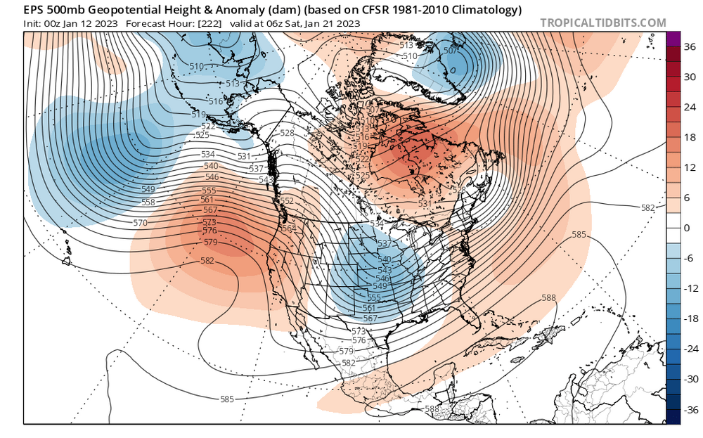
-
High of 44. Reasonably January like.
-
January Mid/Long Range Disco 3: The great recovery or shut the blinds?
WxUSAF replied to psuhoffman's topic in Mid Atlantic
All 3 are better than now though so we’ll get what we get and make a huge fit. Is that how that saying goes? -
January Mid/Long Range Disco 3: The great recovery or shut the blinds?
WxUSAF replied to psuhoffman's topic in Mid Atlantic
No defined 50-50 and not a 5SD -NAO, so maybe we’ll get lucky with some front end sleet? Congrats Burlington. -
January Mid/Long Range Disco 3: The great recovery or shut the blinds?
WxUSAF replied to psuhoffman's topic in Mid Atlantic
EPS pattern is NOICE -
January Mid/Long Range Disco 3: The great recovery or shut the blinds?
WxUSAF replied to psuhoffman's topic in Mid Atlantic
It’s like a 12-24hr can kick, which could just be it “seeing” another shortwave in western Canada. I don’t love the look the GEFS has, but still better than now. Has some potential at least. Let’s see if the EPS holds.