Ski Patroller
-
Posts
47 -
Joined
-
Last visited
Content Type
Profiles
Blogs
Forums
American Weather
Media Demo
Store
Gallery
Everything posted by Ski Patroller
-
Butternut this morning. I believe that they are opening on Saturday, Dec. 13.

-
First Winter Storm to kickoff 2025-26 Winter season
Ski Patroller replied to Baroclinic Zone's topic in New England
Colebrook, NW CT, start time 910AM, 0.5" at 1015AM. T=28.2F. -
Miss "local on the 8's"? Here it is...
Ski Patroller replied to gtg947h's topic in Weather Marketplace
Gonna light this thread back up in case others have not seen these. I run Weatherstar 4000 on an old iPad using a 3D-printed mount. It is really well done. -
Bluesky is for thinking people. Check it out if you value reality.
-
Occasional Thoughts on Climate Change
Ski Patroller replied to donsutherland1's topic in Climate Change
Outstanding piece of writing right there. Thank you for this and your other posts. -
New England Winter 2024-25 Bantering, Whining, and Sobbing Thread
Ski Patroller replied to klw's topic in New England
Cutting NOAA staff is another example of the utter chaos brought by President Musk and his portly pet. WTF is wrong with the voters of this great country of ours? -
New England Winter 2024-25 Bantering, Whining, and Sobbing Thread
Ski Patroller replied to klw's topic in New England
I agree about the balance. Street trees should be managed by arborists with their very high level of education in tree pathology and risk assessment. Foresters are all about growing trees as crops and their education level is not in the realm of individual tree health. CT recently upped the municipal tree warden education and experience requirements so that 1st selectmen and their appointees (often the road foreman) aren't making arboricultural decisions which often led to bad outcomes. People like their street trees. I am completely on board with balancing risk in street tree management but we are nowhere near that right now. -
New England Winter 2024-25 Bantering, Whining, and Sobbing Thread
Ski Patroller replied to klw's topic in New England
I've been involved in this Northeastern issue for several years. It's essentially welfare for contractors as it is grotesque overkill. Federal funding covers 90% of it so state DOT grant managers are thrilled even if it means destroying the landscape aesthetic - their interest is in grabbing every grant they can get, needed or not. The states and federal government could literally save millions by simply having arborists tag hazard trees for removal but they don't do this, they senselessly clearcut. It is out of control across New England and beyond. The income from the trees is insignificant because they are sold below market rate or given to the contractors "for disposal". A recent project in CT produced 16,000 logs pole-to-sawtimber size and the gross receipt to the state was $22,000 ($1.38/tree gross). Most of the contractors have invested in multi-million-dollar specialized machines for clearcutting roadsides instead of hiring manual cutters so the jobs impact of these programs is limited. DOTs say that they are creating pollinator habitat in the deforested areas, ignoring the fact that they are creating sink habitat for insects because, you know, a zillion cars cruising by at 70mph. I've been doing habitat restorations for a living for over 30 years and a key tenet of ecological restoration is don't create production habitat within or adjacent to kill zones. For example, the foraging range of a honeybee is 2 miles (1 mile radius from hive), so ... splat. Additionally, these cleared areas become densely populated by non-native invasive plants whose #1 vector of dispersal is ... roads. These plants are disturbance-specialists and are highly adapted to quickly exploit the macerated soils of the cleared sites. So these roadside-clearing programs are not only contrary to good science and the landscape aesthetic, they greatly aid in the spread of invasives, a phenomenon called "the greatest threat to biodiversity after habitat loss" by E.O. Wilson. But to end on a positive note, we just finished a project in NW Maine that permanently protected 3500 acres in the Mahoosucs. Most of it was paper company land and it will now be forever wild. Onward. -
Occasional Thoughts on Climate Change
Ski Patroller replied to donsutherland1's topic in Climate Change
JFC. How stupid of me to think that all fellow weather fanatics would universally accept the science of climate change. But at a time when every PhD and university is considered an "enemy of the people" and a kakistocrisy has taken control of the government, I should not be surprised. -
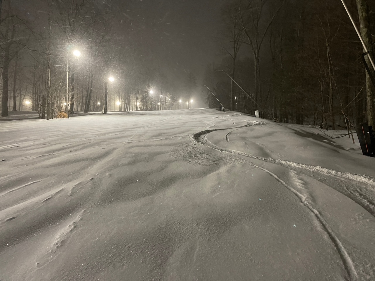
Jiminy Peak, 9:30PM, 1.5 hours into the storm. We were all blown away by how good it got in such a short time.
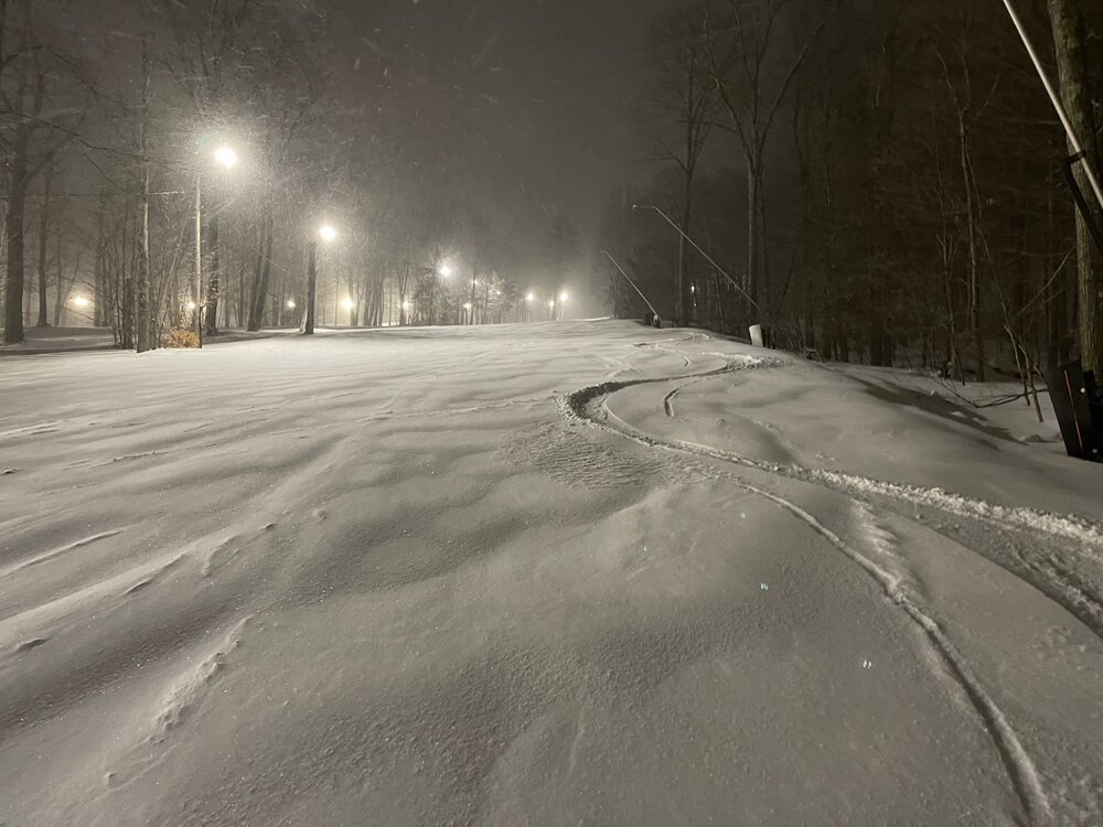
-
December 2024 - Best look to an early December pattern in many a year!
Ski Patroller replied to FXWX's topic in New England
4deg F in NE Litchfield County, CT. -
December 2024 - Best look to an early December pattern in many a year!
Ski Patroller replied to FXWX's topic in New England
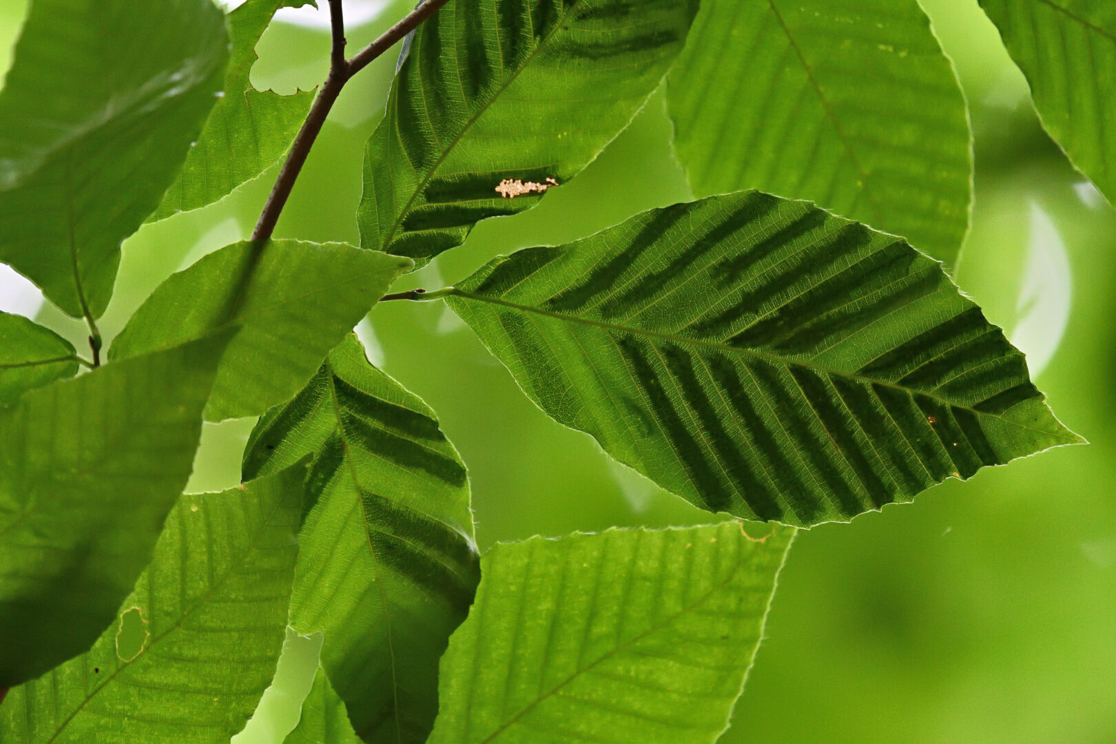
It won't be hard to get soon. The non-native invasive beech nematode Litylenchus crenatae McCannii is in the process of essentially extirpating the species in the Northeast and the state forestry agencies are starting salvage cutting on state lands and encouraging private landowners to do the same (which contravenes good science but they aren't about science so....). Anyway, add American beech to Eastern hemlock, White ash, American chestnut, and American elm. We're losing the Eastern forest in both structural and functional realms.
-
December 2024 - Best look to an early December pattern in many a year!
Ski Patroller replied to FXWX's topic in New England
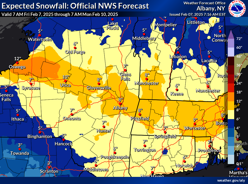
NWS forecast for the Berkshires is for 2.5" to 4.5" of rain between today and Wednesday night.
-
Blowvember - and not named for wind potential
Ski Patroller replied to Go Kart Mozart's topic in New England
Colebrook, Litchfield County, CT, 6AM, 22.8degF, 0.75" new snow. Roads are iced up here. -
Blowvember - and not named for wind potential
Ski Patroller replied to Go Kart Mozart's topic in New England
0.93" in Colebrook for the period. Wicked. I've been writing conservation easements in New England for over 30 years. We never considered landscape-scale fire issues in the contingencies. We were taught in forestry school that droughts like this happened here on 600-1200-year cycles. I just finished drafting the first fire contingency language for a conservation easement project yesterday, allowing 150' of tree clearing from structures, the building of firebreaks, permitted motorized use in firefighting, and allowing fire-control access to water features. Essentially, the California model except we don't allow salvage logging beyond hazard trees. Crazy stuff. -
I like how Stowe puts out detailed daily reports like this. It informs and builds the stoke. I wish most mountains did it.
-
Blowvember - and not named for wind potential
Ski Patroller replied to Go Kart Mozart's topic in New England
22degF at the moment in Colebrook, Litchfield County, CT. -
Significant Miller B Nor'easter Apr 3rd-4th OBS
Ski Patroller replied to wxeyeNH's topic in New England
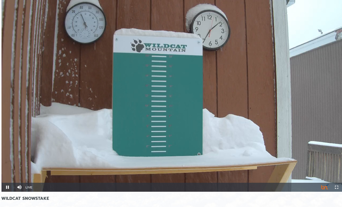
Wildcat reporting 13" of fresh powder in the 6AM Conditions Report and snowing like hell.
-
Nice app, but no way to the subscription model. Let us buy the darn software.
- 2 replies
-
- 1
-

-
- virtual console
- dashboard
- (and 5 more)
-
Significant Miller B Nor'easter watch, Apr 3rd-4th
Ski Patroller replied to Typhoon Tip's topic in New England
https://www.mountwashingtonavalanchecenter.org/forecasts/#/presidential-range Avalanche Watch ISSUED Tuesday, April 2, 2024 - 4:00PM EXPIRES Friday, April 5, 2024 - 4:00PM What A significant winter storm, bringing the possibility of 30+ inches of snow and strong wind to the higher summits in the Presidential Range, will create dangerous avalanche conditions. When In effect from Tuesday, April 2, 2024 - 4:00PM to Friday, April 5, 2024 - 4:00PM Where The Presidential Range avalanche forecast area, including but not limited to Tuckerman Ravine, Huntington Ravine, Gulf of Slides, Great Gulf, King Ravine, Burt Ravine, Ammonoosuc Ravine, Oakes Gulf and steep, open terrain in the mountains that are bounded by US Rt 2, US Rt 302, and NH Rt 16. This includes hiking trails that traverse across steep terrain like Summer Lion Head trail. Similar avalanche danger may exist at locations outside the coverage area where steep, open terrain exists that has collected wind drifted snow. Impacts Large, destructive avalanches are likely to occur naturally and spontaneously and will exist throughout steep terrain including hiking trails.These avalanches may be large enough to bury multiple people, do significant damage to trees or buildings, and will likely run far down in paths or to areas that are normally considered safe zones. Precipitation rates are forecast to be heavy, with 1-2 inches of snow falling per hour at times and visibility limited. Precautionary/Preparedness Actions As the storm develops, expect rapidly changing and dangerous conditions. Strong winds and heavy snow will limit visibility with white out conditions expected. Avoid traveling in or near avalanche terrain. -
Significant Miller B Nor'easter watch, Apr 3rd-4th
Ski Patroller replied to Typhoon Tip's topic in New England
Assuming that the forecast for the Presidential Range holds, any opinions on the expected quality of the snow? Any chance of dry powder? Thanks. -
It was a Flop... February 2024 Disco. Thread
Ski Patroller replied to Prismshine Productions's topic in New England
8.3F in NW CT this morning, and just about 6" of snowpack. -
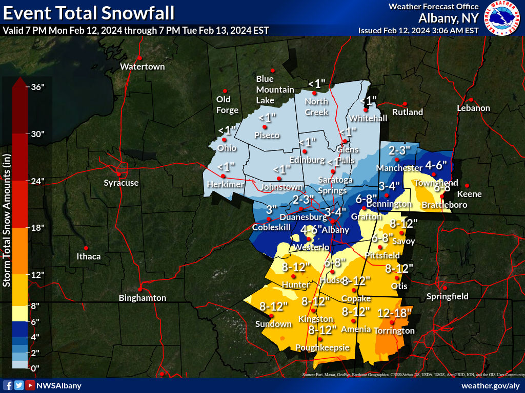
Jiminy Peak may miss the heaviest, too. Hoping that the bullseye moves up into the Berkshires/S. Greens...