

John1122
-
Posts
11,963 -
Joined
-
Last visited
Content Type
Profiles
Blogs
Forums
American Weather
Media Demo
Store
Gallery
Everything posted by John1122
-
 Theres tons of sleet on top of this for the western half of the forum region too. With snow inbound just after it. I don't have the sleet maps but it's a long duration heavy sleet event.
 -
It goes out here frequently. I'm honestly surprised they got it fixed so quickly. Last heavy wet snow outage it was gone for 3 days.
-
They'll probably not change that and leave it as an AN day. I saw a story about snow measurements, someone at the obs site in one city didn't clear the snow board at all for 30 hours and recorded a measurements 8 inches less than surrounding sites. Another cleared it too frequently and recorded 4 inches more than any site around them. They lowered the extra 4 inches measurement by 6 inches and left the one that was 8 inches short alone. That's part of the reason yearly snow numbers are down so dramatically around the country. 1996 here is filled with missing data. It was one of the snowiest if not the snowiest year in Knoxville in the last 25 years. Same with Tri-Cities. Yet there's a ton of M for missing snow data in the record and official totals are less than half what actually fell that year.
-
Yes. It came back around 3, a tree was in the line about 1/2 mile up the mountain from here. Still a ton of outages in Campbell.
-
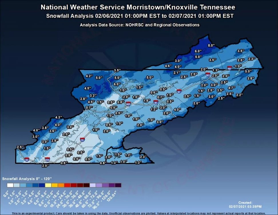
MRX map.
-
Took these around 2pm while waiting on my power to return.
-
Power finally came back. Will upload some winter wonderland photos shortly.
-
If it had been 28 we may have gotten 10+ and I'd have power and all my trees.
-
Typical post around here. This is one thing that happens when you get 6+ inches of heavy wet snow but forecasters down played it in a major way. "We weren’t prepared either. We didn’t even know it was supposed to snow. We have a fireplace for back up but we can’t get it out. My husband ran to town to get something to when it started just in case the power goes out again. Luckily I had just gotten groceries. We will have water since we have city water, but not hot water for a shower."
-
Still no power here. Broken trees in my yard. Lost a good sized piece of my favorite cherry tree.
-
Still no power here. 4-8 inches widespread.
-
I-75 about 6 miles NW of me a couple hours ago. This is why it was having so many issues.
-
I live close to that area.
-
Thats my area. The entire county has been warned off the interstate all night. Power outage map currently. Lots of trees down in the county.
-
I-75 was virtually impassable at mm 130 with nothing at 129, which is Rocky Top. That's been a snow line for a ton of similar storms in my life. You may have solved the why for me with that post.
-
My power is now out. Very wide spread outages across all of Campbell County. This was a true paste bomb.
-
I figured you'd have 2-3 inches at least. I wonder if you were downsloped in the same way that NE areas were expected to be downsloped. Cross Mtn/Frozenhead runs similarly from SW to NE.
-
The GFS and Euro continue to battle for our very souls. Massive differences and neither is backing down really. 06Z is icy and snowy both for the area. All the snow in the middle and west and about half of what is shown here east of the Plateau falls after the event happening now. So either the south is primed for some harsh winter weather or maybe not, according to which wins between the Euro and GFS/Canadian model suite.
-
One of the heaviest bands of the night is about to reach me by the look on the radar.
-
After getting 4.5 inches on the ground here MRX has changed me over to a winter storm warning for up to 6 inches.
-
Future radar just lets go over the Knoxville area between 4:30 and 5.
-
Looks like Nashville itself is getting some heavy snow. Especially downtown and east towards BNA.
-
Great video! Looks like fatties are being ripped.
-
3.5 inches down here and just rolling down still. I'm going to officially apologize to the HRRR from my earlier post because it missed my change over time by 30 minutes.
-


